
Little Pine State Park
Encyclopedia
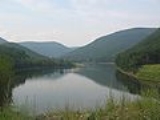
Little Pine State Park is a Pennsylvania state park on 2158 acres (873.3 ha) in Cummings Township
, Lycoming County
, Pennsylvania
in the United States. Little Pine State park is along 4.2 miles (6.8 km) of Little Pine Creek
, a tributary of Pine Creek
, in the midst of the Tiadaghton State Forest
. A dam
on the creek has created a lake covering 94 acres (38 ha) for fishing
, boating
, and swimming. The park is on Pennsylvania Route 4001, 4 miles (6.4 km) northeast of the unincorporated
village
of Waterville or 8 miles (12.9 km) southwest of the village of English Center. The nearest borough
is Jersey Shore, Pennsylvania
, about 15 miles (24.1 km) south at the mouth of Pine Creek on the West Branch Susquehanna River
.
ic hunters known from their stone tool
s.Note: For a general overview of Native American History in the West Branch Susquehanna watershed, see Retrieved on September 30, 2008. Note: ISBN refers to the Heritage Books July 1996 reprint. URL is to a scan of the 1892 version with some OCR
typos. The hunter-gatherer
s of the Archaic period, which lasted locally from 7000 to 1000 BC, used a greater variety of more sophisticated stone artifacts. The Woodland period
marked the gradual transition to semi-permanent villages and horticulture
, between 1000 BC and 1500 AD. Archeological evidence found in the state from this time includes a range of pottery types and styles, burial mounds
, pipes, bows and arrows, and ornaments.
Little Pine State Park is in the West Branch Susquehanna River drainage basin
, the earliest recorded inhabitants of which were the Iroquoian
-speaking Susquehannock
s. They were a matriarchal
society that lived in stockade
d villages of large long houses, and "occasionally inhabited" the mountains surrounding the Pine Creek Gorge. Their numbers were greatly reduced by disease and warfare with the Five Nations of the Iroquois
, and by 1675 they had died out, moved away, or been assimilated
into other tribes.
To fill the void left by the demise of the Susquehannocks, the Iroquois encouraged displaced tribes from the east to settle in the West Branch watershed, including the Shawnee
and Lenape
(or Delaware). The Pine Creek and Little Pine Creek valleys in Cummings Township were used by the Iroquois and Algonkian
tribes as a hunting
ground. Historians believe that there may have been a Shawnee village and burial ground just to the north of Little Pine State Park on Little Pine Creek.
The French and Indian War
(1754–1763) led to the migration of many Native Americans westward to the Ohio River basin. The United States acquired the Last Purchase, including what is now Upper Pine Bottom State Park, from the Iroquois in the Second Treaty of Fort Stanwix
in October 1784. In the years that followed, Native Americans almost entirely left Pennsylvania; however some isolated bands of Natives remained in Pine Creek Gorge until the War of 1812
.
By the mid 19th century greater demand for lumber
reached the Little Pine area, where White pine
and hemlock
covered the surrounding mountainsides. Lumbermen, working for large lumber companies, came and harvested the trees and sent them down the creeks to the West Branch Susquehanna River
to the log boom
and sawmill
s at Williamsport
. The lumber era at Little Pine lasted until 1909, when the last log raft was floated down Little Pine Creek. Remnants of the lumber era can be seen today in and around the park.
area was built along Little Pine Creek by the Civilian Conservation Corps
at what is now the park (but was then CCC Camp S-129). The CCC camp closed in 1937 and the picnic area came under the control of the Pennsylvania Bureau of State Parks. In 1950, the dam was built for both flood
control and recreational purposes. The swimming area, beach, family camping area, and more picnic facilities were added in 1958. Hurricane Agnes
destroyed much of the park's infrastructure in 1972, but improvements and new facilities were constructed along with rebuilding. In 2005 the lake was drained, debris removed, and maintenance work was done on the dam. Nearby Upper Pine Bottom State Park
is maintained by staff from Little Pine State Park.
, Lynx, Wolverine
s, Panthers, Fishers
, Bobcat
s and foxes
; all except the last three are locally extinct as of 2007. The area had herds of American Bison
, Elk
and White-tailed Deer
, and large numbers of Black Bears
, River Otters
, and Beaver
s. Rattlesnake
s and insects plagued early explorers and settlers in the region. Bald Eagle
s have been nesting at the park since 2004. The breeding pair returns annually to a nest on the lakeshore.
The virgin forests cooled the land and streams, and centuries of accumulated organic matter in the forest soil caused slow percolation of rainfall into the creeks and runs so that they flowed more evenly year-round. Pine Creek and its tributaries were home to large numbers of fish, including trout, but dams downstream on the Susquehanna River
have eliminated the shad
and eel
s once found here by blocking their migrations
. Habitat for land animals was destroyed by the clearcutting of forests, but there was also a great deal of hunting, with bounties paid for large predators.
Little Pine Creek's virgin white pines were all clearcut, but in 1925 the Department of Forests and Waters reported "thrifty young growth has now taken in its place". In the 1920s chestnut blight
killed almost all the American Chestnut
trees in the Tiadaghton State Forest, and oak trees suffered from oak leaf tier moths
in the 1950s and oak leaf roller moths
in 1967. Gypsy moth
s defoliated the state forest between 1978 and 1982. As of 2009 the surrounding state forest is "dominated by mixed oak forests", along with hardwoods such as ash, beech
, birch
, cherry, and maple
, as well as hemlock and pine. The Pine Creek Gorge is home to over 225 species of wildflowers, plants and trees, 40 species of mammals, 245 species of birds, and 26 species of fish. Common animals include deer, squirrels, bear, eagles, Wild Turkey
, and ravens.
. The dammed creek formed a lake near what would later be the village of Ansonia in Shippen Township
in Tioga County, and the lake's glacial meltwater overflowed the debris dam
, reversing the flow of Pine Creek. The creek flooded to the south and quickly carved a deep channel on its way to the West Branch Susquehanna River.
The land on which Little Pine State Park sits was part of the coastline of a shallow sea that covered a great portion of what is now North America about 300 million years ago, in the Pennsylvanian subperiod
. The high mountains to the east of the sea gradually eroded, causing a buildup of sediment
made up primarily of clay
, sand
and gravel
. Tremendous pressure on the sediment caused the formation of the rocks that are found today in the Pine Creek drainage basin: sandstone
, shale
, conglomerates
, limestone
, and coal
.
The park is at an elevation of 710 feet (216.4 m) on the Allegheny Plateau
, which formed in the Alleghenian orogeny
some 300 million years ago, when the part of Gondwana
that became Africa collided with what became North America, forming Pangaea
. Although the gorge and its surroundings seem to be mountainous, the area is a dissected plateau
. Years of erosion
have cut away the soft rocks, forming the valleys, and left the hardest of the ancient rocks relatively untouched on the top of sharp ridges, giving them the appearance of "mountains".
Five major rock formations from the Devonian
and Carboniferous
periods are present in Little Pine State Park and Cummings Township. The youngest of these, which forms the highest points in the township, is the early Pennsylvanian
Pottsville Formation
, a gray conglomerate that may contain sandstone, siltstone
, and shale, as well as anthracite coal. Low-sulfur coal was once mined at three locations within the Pine Creek watershed. Below this is the late Mississippian Mauch Chunk Formation
, which is formed with grayish-red shale, siltstone, sandstone, and conglomerate.
Next below these is the Mississippian Burgoon Sandstone
, which is buff colored with shale, coal, and conglomerate inclusions. Below this is the late Devonian
and early Mississippian Huntley Mountain Formation
, which is made of relatively soft grayish-red shale and olive-gray sandstone. The lowest and oldest layer is the red shale and siltstone of the Catskill Formation, some 375 million years old. This layer is relatively soft and easily eroded, which helped to form the Pine Creek Gorge. The source of Little Pine Creek is on Mauch Chunk rock, and the stream cuts deeper as it flows south to Pine Creek. In the park Upper Pine Bottom Run has cut through layers of Burgoon sandstone and Huntley Mountain rock, and downstream of the park to its mouth the deepest parts of the valleys are made of the Catskill Formation.
The Allegheny Plateau has a continental climate
, with occasional severe low temperatures in winter and average daily temperature range
s (difference between the daily high and low) of 20 °F (11 °C) in winter and 26 °F (14 °C) in summer. The mean annual precipitation
for the Pine Creek watershed is 36 inch. January is the coldest month at Little Pine State Park, July the warmest, and June the wettest. The highest recorded temperature at the park was 104 °F (40 °C) in 1988, and the record low was -19 F in 1982.
s only, the rest can accommodate travel trailer
s up to 30 feet (9.1 m) in length. All these sites have electricity. There are also three cottage
s (each can sleep five people) and four group tenting sites (two able to accommodate 40 people and two for 20 people).
Hiking and cross country skiing can be enjoyed on several trails in the park and surrounding Tiadaghton State Forest, including the 5 miles (8 km) Lakeshore trail around the lake, where cross country skiing is available in winter. Part of the Pennsylvania Mid State Trail
, which is 261 miles (420 km) long, runs through the park just south of the dam.
Hunting is possible in season on approximately 1700 acres (688 ha) of the park, plus the adjacent Tiadaghton State Forest lands. Rifle
, pistol
, archery
, and trapping are all possible, with firearm and archery ranges in the park. Typical game animals include bear
, White-tailed deer
, fox
, Ruffed Grouse
, Eastern Gray Squirrel
, and Wild Turkey
. The hunting of Groundhog
s is prohibited.
Picnicking facilities include four picnic areas, each with a pavilion
that may be reserved, and many picnic tables and grills. A volleyball court is available. The lower picnic area is separate from the rest of the park (about 0.5 miles (804.7 m) below the dam and campground).
Sledding and tobogganing in the park are allowed on the shores of the lake in winter. The lake ice must be at least 4 inches (10.2 cm) thick.
to Labor Day
).
Fishing in the park includes fly fishing on 4.2 miles (6.8 km) of Little Pine Creek, bank fishing on 3.3 miles (5.3 km) of lake shoreline, and boat fishing on the lake's 94 acres (38 ha). Fish species include: smallmouth bass, catfish, pickerel, perch, sunfish, and native and stocked
trout (brook, brown, and rainbow). Ice fishing on the lake is possible in winter. The laws and regulations of the Pennsylvania Fish and Boat Commission
apply.
Swimming is open from late May to mid-September, from 8 am to sunset each day. The beach
is sand, with a lawn beside it. No lifeguard
is on duty.
Cummings Township, Lycoming County, Pennsylvania
Cummings Township is a township in Lycoming County, Pennsylvania, in the United States. The population was 355 at the 2000 census. It is part of the Williamsport, Pennsylvania Metropolitan Statistical Area...
, Lycoming County
Lycoming County, Pennsylvania
-Appalachian Mountains and Allegheny Plateau:Lycoming County is divided between the Appalachian Mountains in the south, the dissected Allegheny Plateau in the north and east, and the valley of the West Branch Susquehanna River between these.-West Branch Susquehanna River:The West Branch of the...
, Pennsylvania
Pennsylvania
The Commonwealth of Pennsylvania is a U.S. state that is located in the Northeastern and Mid-Atlantic regions of the United States. The state borders Delaware and Maryland to the south, West Virginia to the southwest, Ohio to the west, New York and Ontario, Canada, to the north, and New Jersey to...
in the United States. Little Pine State park is along 4.2 miles (6.8 km) of Little Pine Creek
Little Pine Creek
Little Pine Creek is a tributary of Pine Creek in Lycoming County, Pennsylvania in the United States.Little Pine Creek is formed by the confluence of Blockhouse Creek and Texas Creek, approximately upstream of Pine Creek. Blacks Creek joins Blockhouse Creek approximately above. of Little Pine...
, a tributary of Pine Creek
Pine Creek (Pennsylvania)
Pine Creek is a tributary of the West Branch Susquehanna River in Potter, Tioga, Lycoming, and Clinton counties in Pennsylvania in the United States. The creek is long...
, in the midst of the Tiadaghton State Forest
Tiadaghton State Forest
Tiadaghton State Forest is a Pennsylvania State Forest in Pennsylvania Bureau of Forestry District #12. The forest is chiefly in western and southern Lycoming County, with small portions in Clinton, Potter, Tioga, and Union counties....
. A dam
Dam
A dam is a barrier that impounds water or underground streams. Dams generally serve the primary purpose of retaining water, while other structures such as floodgates or levees are used to manage or prevent water flow into specific land regions. Hydropower and pumped-storage hydroelectricity are...
on the creek has created a lake covering 94 acres (38 ha) for fishing
Fishing
Fishing is the activity of trying to catch wild fish. Fish are normally caught in the wild. Techniques for catching fish include hand gathering, spearing, netting, angling and trapping....
, boating
Boating
Boating is the leisurely activity of travelling by boat, or the recreational use of a boat whether powerboats, sailboats, or man-powered vessels , focused on the travel itself, as well as sports activities, such as fishing or water skiing...
, and swimming. The park is on Pennsylvania Route 4001, 4 miles (6.4 km) northeast of the unincorporated
Unincorporated area
In law, an unincorporated area is a region of land that is not a part of any municipality.To "incorporate" in this context means to form a municipal corporation, a city, town, or village with its own government. An unincorporated community is usually not subject to or taxed by a municipal government...
village
Village
A village is a clustered human settlement or community, larger than a hamlet with the population ranging from a few hundred to a few thousand , Though often located in rural areas, the term urban village is also applied to certain urban neighbourhoods, such as the West Village in Manhattan, New...
of Waterville or 8 miles (12.9 km) southwest of the village of English Center. The nearest borough
Borough
A borough is an administrative division in various countries. In principle, the term borough designates a self-governing township although, in practice, official use of the term varies widely....
is Jersey Shore, Pennsylvania
Jersey Shore, Pennsylvania
Jersey Shore is a borough in Lycoming County, Pennsylvania, United States. It is on the West Branch Susquehanna River, west by south of Williamsport. It is part of the Williamsport, Pennsylvania Metropolitan Statistical Area. In the past, Jersey Shore held farms, railroad shops, cigar factories, a...
, about 15 miles (24.1 km) south at the mouth of Pine Creek on the West Branch Susquehanna River
West Branch Susquehanna River
The West Branch Susquehanna River is one of the two principal branches, along with the North Branch, of the Susquehanna River in the northeastern United States. The North Branch, which rises in upstate New York, is generally regarded as the extension of the main branch, with the shorter West Branch...
.
Native Americans
Humans have lived in what is now Pennsylvania since at least 10,000 BC. The first settlers were Paleo-Indian nomadNomad
Nomadic people , commonly known as itinerants in modern-day contexts, are communities of people who move from one place to another, rather than settling permanently in one location. There are an estimated 30-40 million nomads in the world. Many cultures have traditionally been nomadic, but...
ic hunters known from their stone tool
Stone tool
A stone tool is, in the most general sense, any tool made either partially or entirely out of stone. Although stone tool-dependent societies and cultures still exist today, most stone tools are associated with prehistoric, particularly Stone Age cultures that have become extinct...
s.Note: For a general overview of Native American History in the West Branch Susquehanna watershed, see Retrieved on September 30, 2008. Note: ISBN refers to the Heritage Books July 1996 reprint. URL is to a scan of the 1892 version with some OCR
Optical character recognition
Optical character recognition, usually abbreviated to OCR, is the mechanical or electronic translation of scanned images of handwritten, typewritten or printed text into machine-encoded text. It is widely used to convert books and documents into electronic files, to computerize a record-keeping...
typos. The hunter-gatherer
Hunter-gatherer
A hunter-gatherer or forage society is one in which most or all food is obtained from wild plants and animals, in contrast to agricultural societies which rely mainly on domesticated species. Hunting and gathering was the ancestral subsistence mode of Homo, and all modern humans were...
s of the Archaic period, which lasted locally from 7000 to 1000 BC, used a greater variety of more sophisticated stone artifacts. The Woodland period
Woodland period
The Woodland period of North American pre-Columbian cultures was from roughly 1000 BCE to 1000 CE in the eastern part of North America. The term "Woodland Period" was introduced in the 1930s as a generic header for prehistoric sites falling between the Archaic hunter-gatherers and the...
marked the gradual transition to semi-permanent villages and horticulture
Horticulture
Horticulture is the industry and science of plant cultivation including the process of preparing soil for the planting of seeds, tubers, or cuttings. Horticulturists work and conduct research in the disciplines of plant propagation and cultivation, crop production, plant breeding and genetic...
, between 1000 BC and 1500 AD. Archeological evidence found in the state from this time includes a range of pottery types and styles, burial mounds
Tumulus
A tumulus is a mound of earth and stones raised over a grave or graves. Tumuli are also known as barrows, burial mounds, Hügelgrab or kurgans, and can be found throughout much of the world. A tumulus composed largely or entirely of stones is usually referred to as a cairn...
, pipes, bows and arrows, and ornaments.
Little Pine State Park is in the West Branch Susquehanna River drainage basin
Drainage basin
A drainage basin is an extent or an area of land where surface water from rain and melting snow or ice converges to a single point, usually the exit of the basin, where the waters join another waterbody, such as a river, lake, reservoir, estuary, wetland, sea, or ocean...
, the earliest recorded inhabitants of which were the Iroquoian
Iroquoian languages
The Iroquoian languages are a First Nation and Native American language family.-Family division:*Ruttenber, Edward Manning. 1992 [1872]. History of the Indian tribes of Hudson's River. Hope Farm Press....
-speaking Susquehannock
Susquehannock
The Susquehannock people were Iroquoian-speaking Native Americans who lived in areas adjacent to the Susquehanna River and its tributaries from the southern part of what is now New York, through Pennsylvania, to the mouth of the Susquehanna in Maryland at the north end of the Chesapeake Bay...
s. They were a matriarchal
Matriarchy
A matriarchy is a society in which females, especially mothers, have the central roles of political leadership and moral authority. It is also sometimes called a gynocratic or gynocentric society....
society that lived in stockade
Stockade
A stockade is an enclosure of palisades and tall walls made of logs placed side by side vertically with the tops sharpened to provide security.-Stockade as a security fence:...
d villages of large long houses, and "occasionally inhabited" the mountains surrounding the Pine Creek Gorge. Their numbers were greatly reduced by disease and warfare with the Five Nations of the Iroquois
Iroquois
The Iroquois , also known as the Haudenosaunee or the "People of the Longhouse", are an association of several tribes of indigenous people of North America...
, and by 1675 they had died out, moved away, or been assimilated
Cultural assimilation
Cultural assimilation is a socio-political response to demographic multi-ethnicity that supports or promotes the assimilation of ethnic minorities into the dominant culture. The term assimilation is often used with regard to immigrants and various ethnic groups who have settled in a new land. New...
into other tribes.
To fill the void left by the demise of the Susquehannocks, the Iroquois encouraged displaced tribes from the east to settle in the West Branch watershed, including the Shawnee
Shawnee
The Shawnee, Shaawanwaki, Shaawanooki and Shaawanowi lenaweeki, are an Algonquian-speaking people native to North America. Historically they inhabited the areas of Ohio, Virginia, West Virginia, Western Maryland, Kentucky, Indiana, and Pennsylvania...
and Lenape
Lenape
The Lenape are an Algonquian group of Native Americans of the Northeastern Woodlands. They are also called Delaware Indians. As a result of the American Revolutionary War and later Indian removals from the eastern United States, today the main groups live in Canada, where they are enrolled in the...
(or Delaware). The Pine Creek and Little Pine Creek valleys in Cummings Township were used by the Iroquois and Algonkian
Algonquian languages
The Algonquian languages also Algonkian) are a subfamily of Native American languages which includes most of the languages in the Algic language family. The name of the Algonquian language family is distinguished from the orthographically similar Algonquin dialect of the Ojibwe language, which is a...
tribes as a hunting
Hunting
Hunting is the practice of pursuing any living thing, usually wildlife, for food, recreation, or trade. In present-day use, the term refers to lawful hunting, as distinguished from poaching, which is the killing, trapping or capture of the hunted species contrary to applicable law...
ground. Historians believe that there may have been a Shawnee village and burial ground just to the north of Little Pine State Park on Little Pine Creek.
The French and Indian War
French and Indian War
The French and Indian War is the common American name for the war between Great Britain and France in North America from 1754 to 1763. In 1756, the war erupted into the world-wide conflict known as the Seven Years' War and thus came to be regarded as the North American theater of that war...
(1754–1763) led to the migration of many Native Americans westward to the Ohio River basin. The United States acquired the Last Purchase, including what is now Upper Pine Bottom State Park, from the Iroquois in the Second Treaty of Fort Stanwix
Treaty of Fort Stanwix (1784)
The Treaty of Fort Stanwix was a treaty signed in October 1784 at Fort Stanwix, located in present-day Rome, New York, between the United States and Native Americans...
in October 1784. In the years that followed, Native Americans almost entirely left Pennsylvania; however some isolated bands of Natives remained in Pine Creek Gorge until the War of 1812
War of 1812
The War of 1812 was a military conflict fought between the forces of the United States of America and those of the British Empire. The Americans declared war in 1812 for several reasons, including trade restrictions because of Britain's ongoing war with France, impressment of American merchant...
.
Lumber era
The first settlers in the Little Pine valley arrived in 1782. John and James English. The English brothers built two sawmills on Little Pine Creek in 1809. Their business grew over the years and by 1816 the village of English Mills was established to house the loggers and their families. The Carson and Patterson families were other early settlers who were involved in farming and the lumber industry.By the mid 19th century greater demand for lumber
Lumber
Lumber or timber is wood in any of its stages from felling through readiness for use as structural material for construction, or wood pulp for paper production....
reached the Little Pine area, where White pine
Eastern White Pine
Pinus strobus, commonly known as the eastern white pine, is a large pine native to eastern North America, occurring from Newfoundland west to Minnesota and southeastern Manitoba, and south along the Appalachian Mountains to the northern edge of Georgia.It is occasionally known as simply white pine,...
and hemlock
Eastern Hemlock
Tsuga canadensis, also known as eastern or Canadian hemlock, and in the French-speaking regions of Canada as pruche du Canada, is a coniferous tree native to eastern North America. It ranges from northeastern Minnesota eastward through southern Quebec to Nova Scotia, and south in the Appalachian...
covered the surrounding mountainsides. Lumbermen, working for large lumber companies, came and harvested the trees and sent them down the creeks to the West Branch Susquehanna River
West Branch Susquehanna River
The West Branch Susquehanna River is one of the two principal branches, along with the North Branch, of the Susquehanna River in the northeastern United States. The North Branch, which rises in upstate New York, is generally regarded as the extension of the main branch, with the shorter West Branch...
to the log boom
Log boom
A log boom is a barrier placed in a river, designed to collect and or contain floating logs timbered from nearby forests sometimes called a fence or bag. The term is also used as a place where logs were collected into booms, as at the mouth of a river...
and sawmill
Sawmill
A sawmill is a facility where logs are cut into boards.-Sawmill process:A sawmill's basic operation is much like those of hundreds of years ago; a log enters on one end and dimensional lumber exits on the other end....
s at Williamsport
Williamsport, Pennsylvania
Williamsport is a city in and the county seat of Lycoming County, Pennsylvania in the United States. In 2009, the population was estimated at 29,304...
. The lumber era at Little Pine lasted until 1909, when the last log raft was floated down Little Pine Creek. Remnants of the lumber era can be seen today in and around the park.
Civilian Conservation Corps
In 1933 a picnicPicnic
In contemporary usage, a picnic can be defined simply as a pleasure excursion at which a meal is eaten outdoors , ideally taking place in a beautiful landscape such as a park, beside a lake or with an interesting view and possibly at a public event such as before an open air theatre performance,...
area was built along Little Pine Creek by the Civilian Conservation Corps
Civilian Conservation Corps
The Civilian Conservation Corps was a public work relief program that operated from 1933 to 1942 in the United States for unemployed, unmarried men from relief families, ages 18–25. A part of the New Deal of President Franklin D...
at what is now the park (but was then CCC Camp S-129). The CCC camp closed in 1937 and the picnic area came under the control of the Pennsylvania Bureau of State Parks. In 1950, the dam was built for both flood
Flood
A flood is an overflow of an expanse of water that submerges land. The EU Floods directive defines a flood as a temporary covering by water of land not normally covered by water...
control and recreational purposes. The swimming area, beach, family camping area, and more picnic facilities were added in 1958. Hurricane Agnes
Hurricane Agnes
Hurricane Agnes was the first tropical storm and first hurricane of the 1972 Atlantic hurricane season. A rare June hurricane, it made landfall on the Florida Panhandle before moving northeastward and ravaging the Mid-Atlantic region as a tropical storm...
destroyed much of the park's infrastructure in 1972, but improvements and new facilities were constructed along with rebuilding. In 2005 the lake was drained, debris removed, and maintenance work was done on the dam. Nearby Upper Pine Bottom State Park
Upper Pine Bottom State Park
Upper Pine Bottom State Park is a Pennsylvania state park in Lycoming County, Pennsylvania in the United States. The park is in Cummings Township on Pennsylvania Route 44 and is surrounded by the Tiadaghton State Forest. It is on Upper Pine Bottom Run, which gave the park its name and is a...
is maintained by staff from Little Pine State Park.
Ecology
Descriptions from early explorers and settlers give an idea of what the Little Pine Creek area was like before it was clearcut. The forest was up to 85 percent hemlock and white pine; hardwoods made up the rest. The Pine Creek watershed, which Little Pine Creek is part of, was home to large predators such as WolvesGray Wolf
The gray wolf , also known as the wolf, is the largest extant wild member of the Canidae family...
, Lynx, Wolverine
Wolverine
The wolverine, pronounced , Gulo gulo , also referred to as glutton, carcajou, skunk bear, or quickhatch, is the largest land-dwelling species of the family Mustelidae . It is a stocky and muscular carnivore, more closely resembling a small bear than other mustelids...
s, Panthers, Fishers
Fisher (animal)
The fisher is a medium-size mammal native to North America. It is a member of the mustelid family, commonly referred to as the weasel family. The fisher is closely related to but larger than the American Marten...
, Bobcat
Bobcat
The bobcat is a North American mammal of the cat family Felidae, appearing during the Irvingtonian stage of around 1.8 million years ago . With twelve recognized subspecies, it ranges from southern Canada to northern Mexico, including most of the continental United States...
s and foxes
Vulpes
Vulpes is a genus of the Canidae family. Its members are referred to as 'true foxes', although there are species in other genera whose common names include the word 'fox'....
; all except the last three are locally extinct as of 2007. The area had herds of American Bison
American Bison
The American bison , also commonly known as the American buffalo, is a North American species of bison that once roamed the grasslands of North America in massive herds...
, Elk
Elk
The Elk is the large deer, also called Cervus canadensis or wapiti, of North America and eastern Asia.Elk may also refer to:Other antlered mammals:...
and White-tailed Deer
White-tailed Deer
The white-tailed deer , also known as the Virginia deer or simply as the whitetail, is a medium-sized deer native to the United States , Canada, Mexico, Central America, and South America as far south as Peru...
, and large numbers of Black Bears
American black bear
The American black bear is a medium-sized bear native to North America. It is the continent's smallest and most common bear species. Black bears are omnivores, with their diets varying greatly depending on season and location. They typically live in largely forested areas, but do leave forests in...
, River Otters
Northern River Otter
The North American river otter , also known as the northern river otter or the common otter, is a semiaquatic mammal endemic to the North American continent, found in and along its waterways and coasts. An adult river otter can weigh between 5 and 14 kg...
, and Beaver
American Beaver
The North American Beaver is the only species of beaver in the Americas, native to North America and introduced to South America. In the United States and Canada, where no other species of beaver occurs, it is usually simply referred to as "beaver"...
s. Rattlesnake
Rattlesnake
Rattlesnakes are a group of venomous snakes of the genera Crotalus and Sistrurus of the subfamily Crotalinae . There are 32 known species of rattlesnake, with between 65-70 subspecies, all native to the Americas, ranging from southern Alberta and southern British Columbia in Canada to Central...
s and insects plagued early explorers and settlers in the region. Bald Eagle
Bald Eagle
The Bald Eagle is a bird of prey found in North America. It is the national bird and symbol of the United States of America. This sea eagle has two known sub-species and forms a species pair with the White-tailed Eagle...
s have been nesting at the park since 2004. The breeding pair returns annually to a nest on the lakeshore.
The virgin forests cooled the land and streams, and centuries of accumulated organic matter in the forest soil caused slow percolation of rainfall into the creeks and runs so that they flowed more evenly year-round. Pine Creek and its tributaries were home to large numbers of fish, including trout, but dams downstream on the Susquehanna River
Susquehanna River
The Susquehanna River is a river located in the northeastern United States. At long, it is the longest river on the American east coast that drains into the Atlantic Ocean, and with its watershed it is the 16th largest river in the United States, and the longest river in the continental United...
have eliminated the shad
Shad
The shads or river herrings comprise the genus Alosa, fish related to herring in the family Clupeidae. They are distinct from others in that family by having a deeper body and spawning in rivers. The several species frequent different areas on both sides of the Atlantic Ocean, Mediterranean Sea....
and eel
Eel
Eels are an order of fish, which consists of four suborders, 20 families, 111 genera and approximately 800 species. Most eels are predators...
s once found here by blocking their migrations
Fish migration
Many types of fish migrate on a regular basis, on time scales ranging from daily to annually or longer, and over distances ranging from a few metres to thousands of kilometres...
. Habitat for land animals was destroyed by the clearcutting of forests, but there was also a great deal of hunting, with bounties paid for large predators.
Little Pine Creek's virgin white pines were all clearcut, but in 1925 the Department of Forests and Waters reported "thrifty young growth has now taken in its place". In the 1920s chestnut blight
Chestnut blight
The pathogenic fungus Cryphonectria parasitica is a member of the ascomycota category, and is the main cause of chestnut blight, a devastating disease of the American chestnut tree that caused a mass extinction in the early 1900s of this once plentiful tree from its historic range in the eastern...
killed almost all the American Chestnut
American Chestnut
The American Chestnut is a large, deciduous tree of the beech family native to eastern North America. Before the species was devastated by the chestnut blight, a fungal disease, it was one of the most important forest trees throughout its range...
trees in the Tiadaghton State Forest, and oak trees suffered from oak leaf tier moths
Croesia semipurpurana
Acleris semipurpurana is a species in the moth family Tortricidae, and one of several species of moth commonly known as Oak leaftier or Oak leaf tier. The larvae feed on the leaves of oak trees in the Eastern United States and southeastern Canada. It can be a major cause of defoliation in oak trees...
in the 1950s and oak leaf roller moths
Archips semiferanus
Archips semiferanus is a species of moth in the family Tortricidae, and one of several species of moth commonly known as Oak leafroller or Oak leaf roller...
in 1967. Gypsy moth
Gypsy moth
The gypsy moth, Lymantria dispar, is a moth in the family Lymantriidae of Eurasian origin. Originally ranging from Europe to Asia, it was introduced to North America in the late 1860s and has been expanding its range ever since...
s defoliated the state forest between 1978 and 1982. As of 2009 the surrounding state forest is "dominated by mixed oak forests", along with hardwoods such as ash, beech
Beech
Beech is a genus of ten species of deciduous trees in the family Fagaceae, native to temperate Europe, Asia and North America.-Habit:...
, birch
Birch
Birch is a tree or shrub of the genus Betula , in the family Betulaceae, closely related to the beech/oak family, Fagaceae. The Betula genus contains 30–60 known taxa...
, cherry, and maple
Maple
Acer is a genus of trees or shrubs commonly known as maple.Maples are variously classified in a family of their own, the Aceraceae, or together with the Hippocastanaceae included in the family Sapindaceae. Modern classifications, including the Angiosperm Phylogeny Group system, favour inclusion in...
, as well as hemlock and pine. The Pine Creek Gorge is home to over 225 species of wildflowers, plants and trees, 40 species of mammals, 245 species of birds, and 26 species of fish. Common animals include deer, squirrels, bear, eagles, Wild Turkey
Wild Turkey
The Wild Turkey is native to North America and is the heaviest member of the Galliformes. It is the same species as the domestic turkey, which derives from the South Mexican subspecies of wild turkey .Adult wild turkeys have long reddish-yellow to grayish-green...
, and ravens.
Geology and climate
Although the rock formations exposed in Little State Park and the Pine Creek Gorge are at least 300 million years old, the gorge itself formed about 20,000 years ago, in the last ice age. Pine Creek had flowed northeasterly until then, but was dammed by rocks, soil, ice, and other debris deposited by the receding Laurentide Continental GlacierLaurentide ice sheet
The Laurentide Ice Sheet was a massive sheet of ice that covered hundreds of thousands of square miles, including most of Canada and a large portion of the northern United States, multiple times during Quaternary glacial epochs. It last covered most of northern North America between c. 95,000 and...
. The dammed creek formed a lake near what would later be the village of Ansonia in Shippen Township
Shippen Township, Tioga County, Pennsylvania
Shippen Township is a township in Tioga County, Pennsylvania, in the United States. The population was 472 at the 2000 census. Two Pennsylvania state parks, Colton Point and Leonard Harrison are in Shippen Township at the Pennsylvania Grand Canyon...
in Tioga County, and the lake's glacial meltwater overflowed the debris dam
Landslide dam
A landslide dam, debris dam, or barrier lake is a natural damming of a river by some kind of mass wasting: landslide, debris flow, rock avalanche or volcano. If it is caused by earthquake, it may also be called a quake lake. Some landslide dams are as high as the largest existing artificial dam...
, reversing the flow of Pine Creek. The creek flooded to the south and quickly carved a deep channel on its way to the West Branch Susquehanna River.
The land on which Little Pine State Park sits was part of the coastline of a shallow sea that covered a great portion of what is now North America about 300 million years ago, in the Pennsylvanian subperiod
Pennsylvanian
The Pennsylvanian is, in the ICS geologic timescale, the younger of two subperiods of the Carboniferous Period. It lasted from roughly . As with most other geochronologic units, the rock beds that define the Pennsylvanian are well identified, but the exact date of the start and end are uncertain...
. The high mountains to the east of the sea gradually eroded, causing a buildup of sediment
Sediment
Sediment is naturally occurring material that is broken down by processes of weathering and erosion, and is subsequently transported by the action of fluids such as wind, water, or ice, and/or by the force of gravity acting on the particle itself....
made up primarily of clay
Clay
Clay is a general term including many combinations of one or more clay minerals with traces of metal oxides and organic matter. Geologic clay deposits are mostly composed of phyllosilicate minerals containing variable amounts of water trapped in the mineral structure.- Formation :Clay minerals...
, sand
Sand
Sand is a naturally occurring granular material composed of finely divided rock and mineral particles.The composition of sand is highly variable, depending on the local rock sources and conditions, but the most common constituent of sand in inland continental settings and non-tropical coastal...
and gravel
Gravel
Gravel is composed of unconsolidated rock fragments that have a general particle size range and include size classes from granule- to boulder-sized fragments. Gravel can be sub-categorized into granule and cobble...
. Tremendous pressure on the sediment caused the formation of the rocks that are found today in the Pine Creek drainage basin: sandstone
Sandstone
Sandstone is a sedimentary rock composed mainly of sand-sized minerals or rock grains.Most sandstone is composed of quartz and/or feldspar because these are the most common minerals in the Earth's crust. Like sand, sandstone may be any colour, but the most common colours are tan, brown, yellow,...
, shale
Shale
Shale is a fine-grained, clastic sedimentary rock composed of mud that is a mix of flakes of clay minerals and tiny fragments of other minerals, especially quartz and calcite. The ratio of clay to other minerals is variable. Shale is characterized by breaks along thin laminae or parallel layering...
, conglomerates
Conglomerate (geology)
A conglomerate is a rock consisting of individual clasts within a finer-grained matrix that have become cemented together. Conglomerates are sedimentary rocks consisting of rounded fragments and are thus differentiated from breccias, which consist of angular clasts...
, limestone
Limestone
Limestone is a sedimentary rock composed largely of the minerals calcite and aragonite, which are different crystal forms of calcium carbonate . Many limestones are composed from skeletal fragments of marine organisms such as coral or foraminifera....
, and coal
Coal
Coal is a combustible black or brownish-black sedimentary rock usually occurring in rock strata in layers or veins called coal beds or coal seams. The harder forms, such as anthracite coal, can be regarded as metamorphic rock because of later exposure to elevated temperature and pressure...
.
The park is at an elevation of 710 feet (216.4 m) on the Allegheny Plateau
Allegheny Plateau
The Allegheny Plateau is a large dissected plateau area in western and central New York, northern and western Pennsylvania, northern and western West Virginia, and eastern Ohio...
, which formed in the Alleghenian orogeny
Alleghenian orogeny
The Alleghenian orogeny or Appalachian orogeny is one of the geological mountain-forming events that formed the Appalachian Mountains and Allegheny Mountains. The term and spelling Alleghany orogeny was originally proposed by H.P. Woodward in 1957....
some 300 million years ago, when the part of Gondwana
Gondwana
In paleogeography, Gondwana , originally Gondwanaland, was the southernmost of two supercontinents that later became parts of the Pangaea supercontinent. It existed from approximately 510 to 180 million years ago . Gondwana is believed to have sutured between ca. 570 and 510 Mya,...
that became Africa collided with what became North America, forming Pangaea
Pangaea
Pangaea, Pangæa, or Pangea is hypothesized as a supercontinent that existed during the Paleozoic and Mesozoic eras about 250 million years ago, before the component continents were separated into their current configuration....
. Although the gorge and its surroundings seem to be mountainous, the area is a dissected plateau
Dissected plateau
A dissected plateau is a plateau area that has been severely eroded so that the relief is sharp. Such an area may be referred to as mountainous, but dissected plateaus are distinguishable from orogenic mountain belts by the lack of folding, metamorphism, extensive faulting, or magmatic activity...
. Years of erosion
Erosion
Erosion is when materials are removed from the surface and changed into something else. It only works by hydraulic actions and transport of solids in the natural environment, and leads to the deposition of these materials elsewhere...
have cut away the soft rocks, forming the valleys, and left the hardest of the ancient rocks relatively untouched on the top of sharp ridges, giving them the appearance of "mountains".
Five major rock formations from the Devonian
Devonian
The Devonian is a geologic period and system of the Paleozoic Era spanning from the end of the Silurian Period, about 416.0 ± 2.8 Mya , to the beginning of the Carboniferous Period, about 359.2 ± 2.5 Mya...
and Carboniferous
Carboniferous
The Carboniferous is a geologic period and system that extends from the end of the Devonian Period, about 359.2 ± 2.5 Mya , to the beginning of the Permian Period, about 299.0 ± 0.8 Mya . The name is derived from the Latin word for coal, carbo. Carboniferous means "coal-bearing"...
periods are present in Little Pine State Park and Cummings Township. The youngest of these, which forms the highest points in the township, is the early Pennsylvanian
Pennsylvanian
The Pennsylvanian is, in the ICS geologic timescale, the younger of two subperiods of the Carboniferous Period. It lasted from roughly . As with most other geochronologic units, the rock beds that define the Pennsylvanian are well identified, but the exact date of the start and end are uncertain...
Pottsville Formation
Pottsville Formation
The Pennsylvanian Pottsville Formation is a mapped bedrock unit in Pennsylvania, western Maryland, West Virginia, and Ohio. The formation is also recognized in Alabama. It is a major ridge-former In the Ridge-and-Valley Appalachians of the eastern United States...
, a gray conglomerate that may contain sandstone, siltstone
Siltstone
Siltstone is a sedimentary rock which has a grain size in the silt range, finer than sandstone and coarser than claystones.- Description :As its name implies, it is primarily composed of silt sized particles, defined as grains 1/16 - 1/256 mm or 4 to 8 on the Krumbein phi scale...
, and shale, as well as anthracite coal. Low-sulfur coal was once mined at three locations within the Pine Creek watershed. Below this is the late Mississippian Mauch Chunk Formation
Mauch Chunk Formation
The Mississippian Mauch Chunk Formation is a mapped bedrock unit in Pennsylvania, Maryland, and West Virginia. It is named for the borough of Mauch Chunk, now known as Jim Thorpe, Pennsylvania.-Description:...
, which is formed with grayish-red shale, siltstone, sandstone, and conglomerate.
Next below these is the Mississippian Burgoon Sandstone
Pocono Formation
The Mississippian Pocono Formation is a mapped bedrock unit in Pennsylvania, Maryland, and West Virginia, USA. It is also known as the Pocono Group in Maryland and West Virginia,...
, which is buff colored with shale, coal, and conglomerate inclusions. Below this is the late Devonian
Devonian
The Devonian is a geologic period and system of the Paleozoic Era spanning from the end of the Silurian Period, about 416.0 ± 2.8 Mya , to the beginning of the Carboniferous Period, about 359.2 ± 2.5 Mya...
and early Mississippian Huntley Mountain Formation
Huntley Mountain Formation
The Huntley Mountain Formation is a late Devonian and early Mississippian mapped bedrock unit in Pennsylvania, in the United States.-Description:The formation is composed of relatively soft grayish-red shale and olive-gray sandstone...
, which is made of relatively soft grayish-red shale and olive-gray sandstone. The lowest and oldest layer is the red shale and siltstone of the Catskill Formation, some 375 million years old. This layer is relatively soft and easily eroded, which helped to form the Pine Creek Gorge. The source of Little Pine Creek is on Mauch Chunk rock, and the stream cuts deeper as it flows south to Pine Creek. In the park Upper Pine Bottom Run has cut through layers of Burgoon sandstone and Huntley Mountain rock, and downstream of the park to its mouth the deepest parts of the valleys are made of the Catskill Formation.
The Allegheny Plateau has a continental climate
Continental climate
Continental climate is a climate characterized by important annual variation in temperature due to the lack of significant bodies of water nearby...
, with occasional severe low temperatures in winter and average daily temperature range
Temperature range
Atmospheric temperature range is the numerical difference between the minimum and maximum values of temperature observed in a given location....
s (difference between the daily high and low) of 20 °F (11 °C) in winter and 26 °F (14 °C) in summer. The mean annual precipitation
Precipitation (meteorology)
In meteorology, precipitation In meteorology, precipitation In meteorology, precipitation (also known as one of the classes of hydrometeors, which are atmospheric water phenomena is any product of the condensation of atmospheric water vapor that falls under gravity. The main forms of precipitation...
for the Pine Creek watershed is 36 inch. January is the coldest month at Little Pine State Park, July the warmest, and June the wettest. The highest recorded temperature at the park was 104 °F (40 °C) in 1988, and the record low was -19 F in 1982.
Facilities and recreation
Camping season at Little Pine State Park runs from the first weekend in April to mid-December. The park has 104 modern camping sites, 6 for tentTent
A tent is a shelter consisting of sheets of fabric or other material draped over or attached to a frame of poles or attached to a supporting rope. While smaller tents may be free-standing or attached to the ground, large tents are usually anchored using guy ropes tied to stakes or tent pegs...
s only, the rest can accommodate travel trailer
Travel trailer
A travel trailer or caravan is towed behind a road vehicle to provide a place to sleep which is more comfortable and protected than a tent . It provides the means for people to have their own home on a journey or a vacation, without relying on a motel or hotel, and enables them to stay in places...
s up to 30 feet (9.1 m) in length. All these sites have electricity. There are also three cottage
Cottage
__toc__In modern usage, a cottage is usually a modest, often cozy dwelling, typically in a rural or semi-rural location. However there are cottage-style dwellings in cities, and in places such as Canada the term exists with no connotations of size at all...
s (each can sleep five people) and four group tenting sites (two able to accommodate 40 people and two for 20 people).
Hiking and cross country skiing can be enjoyed on several trails in the park and surrounding Tiadaghton State Forest, including the 5 miles (8 km) Lakeshore trail around the lake, where cross country skiing is available in winter. Part of the Pennsylvania Mid State Trail
Pennsylvania Mid State Trail
The Mid State Trail is a long main trail network with many side trails located in the Ridge-and-valley Appalachians and Allegheny Plateau of Central Pennsylvania. It is known as "The Wildest Trail in Pennsylvania"...
, which is 261 miles (420 km) long, runs through the park just south of the dam.
Hunting is possible in season on approximately 1700 acres (688 ha) of the park, plus the adjacent Tiadaghton State Forest lands. Rifle
Rifle
A rifle is a firearm designed to be fired from the shoulder, with a barrel that has a helical groove or pattern of grooves cut into the barrel walls. The raised areas of the rifling are called "lands," which make contact with the projectile , imparting spin around an axis corresponding to the...
, pistol
Pistol
When distinguished as a subset of handguns, a pistol is a handgun with a chamber that is integral with the barrel, as opposed to a revolver, wherein the chamber is separate from the barrel as a revolving cylinder. Typically, pistols have an effective range of about 100 feet.-History:The pistol...
, archery
Archery
Archery is the art, practice, or skill of propelling arrows with the use of a bow, from Latin arcus. Archery has historically been used for hunting and combat; in modern times, however, its main use is that of a recreational activity...
, and trapping are all possible, with firearm and archery ranges in the park. Typical game animals include bear
American black bear
The American black bear is a medium-sized bear native to North America. It is the continent's smallest and most common bear species. Black bears are omnivores, with their diets varying greatly depending on season and location. They typically live in largely forested areas, but do leave forests in...
, White-tailed deer
White-tailed Deer
The white-tailed deer , also known as the Virginia deer or simply as the whitetail, is a medium-sized deer native to the United States , Canada, Mexico, Central America, and South America as far south as Peru...
, fox
Fox
Fox is a common name for many species of omnivorous mammals belonging to the Canidae family. Foxes are small to medium-sized canids , characterized by possessing a long narrow snout, and a bushy tail .Members of about 37 species are referred to as foxes, of which only 12 species actually belong to...
, Ruffed Grouse
Ruffed Grouse
The Ruffed Grouse is a medium-sized grouse occurring in forests from the Appalachian Mountains across Canada to Alaska. It is non-migratory.The Ruffed Grouse is frequently referred to as a "partridge"...
, Eastern Gray Squirrel
Eastern Gray Squirrel
The eastern gray squirrel is a tree squirrel in the genus Sciurus native to the eastern and midwestern United States, and to the southerly portions of the eastern provinces of Canada...
, and Wild Turkey
Wild Turkey
The Wild Turkey is native to North America and is the heaviest member of the Galliformes. It is the same species as the domestic turkey, which derives from the South Mexican subspecies of wild turkey .Adult wild turkeys have long reddish-yellow to grayish-green...
. The hunting of Groundhog
Groundhog
The groundhog , also known as a woodchuck, whistle-pig, or in some areas as a land-beaver, is a rodent of the family Sciuridae, belonging to the group of large ground squirrels known as marmots. Other marmots, such as the yellow-bellied and hoary marmots, live in rocky and mountainous areas, but...
s is prohibited.
Picnicking facilities include four picnic areas, each with a pavilion
Pavilion (structure)
In architecture a pavilion has two main meanings.-Free-standing structure:Pavilion may refer to a free-standing structure sited a short distance from a main residence, whose architecture makes it an object of pleasure. Large or small, there is usually a connection with relaxation and pleasure in...
that may be reserved, and many picnic tables and grills. A volleyball court is available. The lower picnic area is separate from the rest of the park (about 0.5 miles (804.7 m) below the dam and campground).
Sledding and tobogganing in the park are allowed on the shores of the lake in winter. The lake ice must be at least 4 inches (10.2 cm) thick.
Little Pine Lake
Boating on the lake is allowed with electric motors only. There is one boat launch area for the lake, 25 mooring places (available April 1 to November 1), and rental paddleboats, canoes and rowboats available (from Memorial DayMemorial Day
Memorial Day is a United States federal holiday observed on the last Monday of May. Formerly known as Decoration Day, it originated after the American Civil War to commemorate the fallen Union soldiers of the Civil War...
to Labor Day
Labor Day
Labor Day is a United States federal holiday observed on the first Monday in September that celebrates the economic and social contributions of workers.-History:...
).
Fishing in the park includes fly fishing on 4.2 miles (6.8 km) of Little Pine Creek, bank fishing on 3.3 miles (5.3 km) of lake shoreline, and boat fishing on the lake's 94 acres (38 ha). Fish species include: smallmouth bass, catfish, pickerel, perch, sunfish, and native and stocked
Fish stocking
Fish stocking is the practice of raising fish in a hatchery and releasing them into a river, lake, or the ocean to supplement existing populations, or to create a population where none exists...
trout (brook, brown, and rainbow). Ice fishing on the lake is possible in winter. The laws and regulations of the Pennsylvania Fish and Boat Commission
Pennsylvania Fish and Boat Commission
The Pennsylvania Fish and Boat Commission is the state agency responsible for the regulation of all fishing and boating in the Commonwealth of Pennsylvania...
apply.
Swimming is open from late May to mid-September, from 8 am to sunset each day. The beach
Beach
A beach is a geological landform along the shoreline of an ocean, sea, lake or river. It usually consists of loose particles which are often composed of rock, such as sand, gravel, shingle, pebbles or cobblestones...
is sand, with a lawn beside it. No lifeguard
Lifeguard
A lifeguard supervises the safety and rescue of swimmers, surfers, and other water sports participants such as in a swimming pool, water park, or beach. Lifeguards are strong swimmers and trained in first aid, certified in water rescue using a variety of aids and equipment depending on...
is on duty.
Nearby state parks
The following state parks are within 30 miles (48.3 km) of Little Pine State Park:- Bald Eagle State ParkBald Eagle State ParkBald Eagle State Park is a Pennsylvania state park in Howard, Liberty, and Marion townships in Centre County, Pennsylvania in the United States. The park includes the Joseph Foster Sayers Reservoir, formed by damming Bald Eagle Creek and other smaller streams and covering . Bald Eagle State Park...
(Centre CountyCentre County, PennsylvaniaCentre County is a county located in the U.S. state of Pennsylvania. It is part of the State College, Pennsylvania Metropolitan Statistical Area. As of 2010, the population was 153,990....
) - Bucktail State Park Natural AreaBucktail State Park Natural AreaBucktail State Park Natural Area is a Pennsylvania state park in Cameron and Clinton Counties in Pennsylvania in the United States. The park follows Pennsylvania Route 120 for between Emporium and Lock Haven...
(CameronCameron County, PennsylvaniaAs of the census of 2000, there were 5,974 people, 2,465 households, and 1,624 families residing in the county. The population density was 15 people per square mile . There were 4,592 housing units at an average density of 12 per square mile...
and Clinton CountiesClinton County, PennsylvaniaAs of the census of 2000, there were 37,914 people, 14,773 households, and 9,927 families residing in the county. The population density was 43 people per square mile . There were 18,166 housing units at an average density of 20 per square mile...
) - Colton Point State ParkColton Point State ParkColton Point State Park is a Pennsylvania state park in Tioga County, Pennsylvania, in the United States. It is on the west side of the Pine Creek Gorge, also known as the Grand Canyon of Pennsylvania, which is deep and nearly across at this location. The park extends from the creek in the...
(Tioga CountyTioga County, PennsylvaniaTioga County is a county located in the U.S. state of Pennsylvania. As of the 2010 census, the population was 41,981. Tioga County was created on March 26, 1804, from part of Lycoming County and named for the Tioga River. Its county seat is Wellsboro....
) - Hyner Run State ParkHyner Run State ParkHyner Run State Park is a Pennsylvania state park in Chapman Township, Clinton County, Pennsylvania in the United States. The park is east of Renovo and 3 miles north of Hyner on Pennsylvania Route 120...
(Clinton County) - Hyner View State ParkHyner View State ParkHyner View State Park is a Pennsylvania state park in Chapman Township, Clinton County, Pennsylvania in the United States. The park is east of Renovo and north of Hyner on Pennsylvania Route 120...
(Clinton County) - Kettle Creek State ParkKettle Creek State ParkKettle Creek State Park is a Pennsylvania state park in Leidy Township, Clinton County, Pennsylvania in the United States. The park is in a valley and is surrounded by mountains and wilderness. It features the Alvin R. Bush Dam built in 1961 by the U.S. Army Corps of Engineers as a flood control...
(Clinton County) - Leonard Harrison State ParkLeonard Harrison State ParkLeonard Harrison State Park is a Pennsylvania state park in Tioga County, Pennsylvania, in the United States. It is on the east rim of the Pine Creek Gorge, also known as the Grand Canyon of Pennsylvania, which is deep and nearly across here. It also serves as headquarters for the adjoining...
(Tioga County) - McCalls Dam State ParkMcCalls Dam State ParkMcCalls Dam State Park is a Pennsylvania state park on in Miles Township, Centre County, Pennsylvania in the United States. The park is in the eastern most tip of Centre County, south of Clinton County and north of Union County. McCalls Dam State Park is in a remote location on a dirt road between...
(Centre County) - Ole Bull State ParkOle Bull State ParkOle Bull State Park is a Pennsylvania state park in Stewardson Township, Potter County, Pennsylvania in the United States. The park is located on Pennsylvania Route 144, north of Renovo and south of Galeton. Ole Bull State Park is in the Kettle Creek Valley, and is surrounded by Susquehannock...
(Potter CountyPotter County, PennsylvaniaPotter County is a county located in the U.S. state of Pennsylvania. It is in the Allegheny Plateau region. As of 2010, the population was 17,457. Its county seat is Coudersport. Potter County was named after James Potter, who was a general from Pennsylvania in the Continental Army during the...
) - Ravensburg State ParkRavensburg State ParkRavensburg State Park is a Pennsylvania state park in Crawford Township in Clinton County, Pennsylvania in the United States. It is in a gorge carved by Rauchtown Run through the side of Nippenose Mountain. Ravensburg State Park is of wooded land that is almost entirely surrounded by Tiadaghton...
(Clinton County) - R. B. Winter State ParkR. B. Winter State ParkR. B. Winter State Park is a Pennsylvania state park on in Hartley Township, Union County, Pennsylvania in the United States. It is in the ridge and valley region of Pennsylvania and is surrounded by Bald Eagle State Forest. R. B. Winter State Park is in a shallow basin that is surrounded by ridges...
(Union CountyUnion County, Pennsylvania-Demographics:As of the census of 2000, there were 41,624 people, 13,178 households, and 9,211 families residing in the county. The population density was 131 people per square mile . There were 14,684 housing units at an average density of 46 per square mile...
) - Sand Bridge State ParkSand Bridge State ParkSand Bridge State Park is a Pennsylvania state park on in Lewis Township, Union County, Pennsylvania in the United States. The park is the smallest state park in Pennsylvania and consists of a picnic area just off Pennsylvania Route 192. It has three picnic pavilions that were built by the...
(Union County) - Susquehanna State ParkSusquehanna State Park (Pennsylvania)Susquehanna State Park is a Pennsylvania state park on in Williamsport in Lycoming County, Pennsylvania in the United States. The park is on the West Branch Susquehanna River in the western part of Williamsport, and is operated by the Williamsport / Lycoming Chamber of Commerce in cooperation with...
(Lycoming County) - Upper Pine Bottom State ParkUpper Pine Bottom State ParkUpper Pine Bottom State Park is a Pennsylvania state park in Lycoming County, Pennsylvania in the United States. The park is in Cummings Township on Pennsylvania Route 44 and is surrounded by the Tiadaghton State Forest. It is on Upper Pine Bottom Run, which gave the park its name and is a...
(Lycoming County)