
Sand Bridge State Park
Encyclopedia
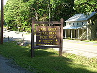
Sand Bridge State Park is a Pennsylvania state park on 3 acre (0.01214058 km²) in Lewis Township
, Union County
, Pennsylvania
in the United States. The park is the smallest state park in Pennsylvania and consists of a picnic
area just off Pennsylvania Route 192
. It has three picnic pavilions
that were built by the Civilian Conservation Corps
during the Great Depression
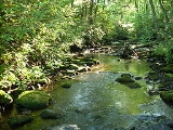
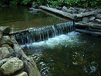
. Rapid Run, a trout
stream that is stocked
by the Pennsylvania Fish and Boat Commission
, flows through Sand Bridge State Park. The park attracted 17,000 visitors in 2008. The name Sand Bridge remains a mystery. No one, according to the parks official website knows why the area is known as Sand Bridge. The park is surrounded by Bald Eagle State Forest
and became a Pennsylvania State park in 1978.
 The following state parks are within 30 miles (48 km) of Sand Bridge State Park:
Lewis Township, Union County, Pennsylvania
Lewis Township is a township in Union County, Pennsylvania, United States. The population was 1,405 at the 2000 census. Sand Bridge State Park a Pennsylvania state park is in Lewis Township along Pennsylvania Route 192.-Geography:...
, Union County
Union County, Pennsylvania
-Demographics:As of the census of 2000, there were 41,624 people, 13,178 households, and 9,211 families residing in the county. The population density was 131 people per square mile . There were 14,684 housing units at an average density of 46 per square mile...
, Pennsylvania
Pennsylvania
The Commonwealth of Pennsylvania is a U.S. state that is located in the Northeastern and Mid-Atlantic regions of the United States. The state borders Delaware and Maryland to the south, West Virginia to the southwest, Ohio to the west, New York and Ontario, Canada, to the north, and New Jersey to...
in the United States. The park is the smallest state park in Pennsylvania and consists of a picnic
Picnic
In contemporary usage, a picnic can be defined simply as a pleasure excursion at which a meal is eaten outdoors , ideally taking place in a beautiful landscape such as a park, beside a lake or with an interesting view and possibly at a public event such as before an open air theatre performance,...
area just off Pennsylvania Route 192
Pennsylvania Route 192
Pennsylvania Route 192 is a state highway located in central Pennsylvania. The western terminus of the route is at Pennsylvania Route 144 in Centre Hall. The eastern terminus is at U.S. Route 15 in Lewisburg.-Centre County:...
. It has three picnic pavilions
Pavilion (structure)
In architecture a pavilion has two main meanings.-Free-standing structure:Pavilion may refer to a free-standing structure sited a short distance from a main residence, whose architecture makes it an object of pleasure. Large or small, there is usually a connection with relaxation and pleasure in...
that were built by the Civilian Conservation Corps
Civilian Conservation Corps
The Civilian Conservation Corps was a public work relief program that operated from 1933 to 1942 in the United States for unemployed, unmarried men from relief families, ages 18–25. A part of the New Deal of President Franklin D...
during the Great Depression
Great Depression
The Great Depression was a severe worldwide economic depression in the decade preceding World War II. The timing of the Great Depression varied across nations, but in most countries it started in about 1929 and lasted until the late 1930s or early 1940s...
. Rapid Run, a trout
Trout
Trout is the name for a number of species of freshwater and saltwater fish belonging to the Salmoninae subfamily of the family Salmonidae. Salmon belong to the same family as trout. Most salmon species spend almost all their lives in salt water...
stream that is stocked
Fish stocking
Fish stocking is the practice of raising fish in a hatchery and releasing them into a river, lake, or the ocean to supplement existing populations, or to create a population where none exists...
by the Pennsylvania Fish and Boat Commission
Pennsylvania Fish and Boat Commission
The Pennsylvania Fish and Boat Commission is the state agency responsible for the regulation of all fishing and boating in the Commonwealth of Pennsylvania...
, flows through Sand Bridge State Park. The park attracted 17,000 visitors in 2008. The name Sand Bridge remains a mystery. No one, according to the parks official website knows why the area is known as Sand Bridge. The park is surrounded by Bald Eagle State Forest
Bald Eagle State Forest
Bald Eagle State Forest is a Pennsylvania state forest in Pennsylvania Bureau of Forestry District #7. The main office is located in Laurelton in Union County, Pennsylvania, in the United States. The forest is found in Centre, Clinton, Mifflin, Snyder, and Union Counties...
and became a Pennsylvania State park in 1978.
Nearby state parks
- Bald Eagle State ParkBald Eagle State ParkBald Eagle State Park is a Pennsylvania state park in Howard, Liberty, and Marion townships in Centre County, Pennsylvania in the United States. The park includes the Joseph Foster Sayers Reservoir, formed by damming Bald Eagle Creek and other smaller streams and covering . Bald Eagle State Park...
(Centre CountyCentre County, PennsylvaniaCentre County is a county located in the U.S. state of Pennsylvania. It is part of the State College, Pennsylvania Metropolitan Statistical Area. As of 2010, the population was 153,990....
) - Bucktail State Park Natural AreaBucktail State Park Natural AreaBucktail State Park Natural Area is a Pennsylvania state park in Cameron and Clinton Counties in Pennsylvania in the United States. The park follows Pennsylvania Route 120 for between Emporium and Lock Haven...
(CameronCameron County, PennsylvaniaAs of the census of 2000, there were 5,974 people, 2,465 households, and 1,624 families residing in the county. The population density was 15 people per square mile . There were 4,592 housing units at an average density of 12 per square mile...
and Clinton CountiesClinton County, PennsylvaniaAs of the census of 2000, there were 37,914 people, 14,773 households, and 9,927 families residing in the county. The population density was 43 people per square mile . There were 18,166 housing units at an average density of 20 per square mile...
) - Little Pine State ParkLittle Pine State ParkLittle Pine State Park is a Pennsylvania state park on in Cummings Township, Lycoming County, Pennsylvania in the United States. Little Pine State park is along of Little Pine Creek, a tributary of Pine Creek, in the midst of the Tiadaghton State Forest. A dam on the creek has created a lake...
(Lycoming CountyLycoming County, Pennsylvania-Appalachian Mountains and Allegheny Plateau:Lycoming County is divided between the Appalachian Mountains in the south, the dissected Allegheny Plateau in the north and east, and the valley of the West Branch Susquehanna River between these.-West Branch Susquehanna River:The West Branch of the...
) - McCalls Dam State ParkMcCalls Dam State ParkMcCalls Dam State Park is a Pennsylvania state park on in Miles Township, Centre County, Pennsylvania in the United States. The park is in the eastern most tip of Centre County, south of Clinton County and north of Union County. McCalls Dam State Park is in a remote location on a dirt road between...
(Centre County) - Milton State ParkMilton State ParkMilton State Park is an Pennsylvania state park in Milton in Northumberland County, Pennsylvania in the United States. The park is on Montgomery Island in the West Branch Susquehanna River, just east of the village of West Milton in Union County. Milton State Park is on Pennsylvania Route...
(Northumberland CountyNorthumberland County, PennsylvaniaThere were 38,835 households out of which 27.30% had children under the age of 18 living with them, 52.40% were married couples living together, 9.60% had a female householder with no husband present, and 34.10% were non-families. 30.20% of all households were made up of individuals and 15.50% had...
) - Poe Paddy State ParkPoe Paddy State ParkPoe Paddy State Park is a Pennsylvania state park in Haines Township, Centre County, Pennsylvania in the United States. The park is surrounded by Bald Eagle State Forest. Poe Valley State Park is to the east. The park is at the confluence of Big Poe Creek and Penns Creek. Poe Paddy State Park is...
(Centre County) - Poe Valley State ParkPoe Valley State ParkPoe Valley State Park is a Pennsylvania state park in Penn Township, Centre County, Pennsylvania in the United States. The park is surrounded by Bald Eagle State Forest. Poe Paddy State Park is to the west. The forests of the park surround the Poe Lake. Poe Valley State Park is in isolated Poe...
(Centre County) - Ravensburg State ParkRavensburg State ParkRavensburg State Park is a Pennsylvania state park in Crawford Township in Clinton County, Pennsylvania in the United States. It is in a gorge carved by Rauchtown Run through the side of Nippenose Mountain. Ravensburg State Park is of wooded land that is almost entirely surrounded by Tiadaghton...
(Clinton County) - R. B. Winter State ParkR. B. Winter State ParkR. B. Winter State Park is a Pennsylvania state park on in Hartley Township, Union County, Pennsylvania in the United States. It is in the ridge and valley region of Pennsylvania and is surrounded by Bald Eagle State Forest. R. B. Winter State Park is in a shallow basin that is surrounded by ridges...
(Union County) - Reeds Gap State ParkReeds Gap State ParkReeds Gap State Park is a Pennsylvania state park in Armagh Township, Mifflin County, Pennsylvania in the United States. The park is largely a wilderness area with large white pine and hemlock trees. Honey Creek flows through the park, providing a habitat for trout. Reeds Gap State Park is from U.S...
(Mifflin CountyMifflin County, PennsylvaniaMifflin County is a county located in the U.S. state of Pennsylvania. As of 2010, the population was 46,682. Its county seat is Lewistown. It is named after Thomas Mifflin, the first Governor of Pennsylvania.-Geography:...
) - Shikellamy State ParkShikellamy State ParkShikellamy State Park is a Pennsylvania state park located at the confluence of the West Branch Susquehanna River and Susquehanna River in Pennsylvania in the United States. The park is divided into two sections. The older part, on a bluff on the western bank of the river, is the Shikellamy...
(Union and Northumberland Counties) - Susquehanna State ParkSusquehanna State Park (Pennsylvania)Susquehanna State Park is a Pennsylvania state park on in Williamsport in Lycoming County, Pennsylvania in the United States. The park is on the West Branch Susquehanna River in the western part of Williamsport, and is operated by the Williamsport / Lycoming Chamber of Commerce in cooperation with...
(Lycoming County) - Upper Pine Bottom State ParkUpper Pine Bottom State ParkUpper Pine Bottom State Park is a Pennsylvania state park in Lycoming County, Pennsylvania in the United States. The park is in Cummings Township on Pennsylvania Route 44 and is surrounded by the Tiadaghton State Forest. It is on Upper Pine Bottom Run, which gave the park its name and is a...
(Lycoming County)