
Bucktail State Park Natural Area
Encyclopedia
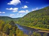
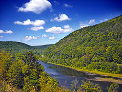
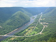
Bucktail State Park Natural Area is a 16433 acres (6,650.2 ha) Pennsylvania state park in Cameron
and Clinton
Counties in Pennsylvania
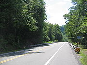
in the United States. The park follows Pennsylvania Route 120
for 75 miles (120.7 km) between Emporium
(in Cameron County, which contains 3239 acres (1,310.8 ha) of the park) and Lock Haven
(in Clinton County, which contains the other 11800 acres (4,775.3 ha)). Bucktail State Park Natural Area park runs along Sinnemahoning Creek
and the West Branch Susquehanna River
and also passes through Renovo
(in Clinton County). The park is named for the Civil War Pennsylvania Bucktail Regiment
and is primarily dedicated to wildlife viewing, especially elk
.
 The course of Bucktail State Park Natural Area is as follows: leaving the city of Lock Haven, Pennsylvania Route 120 and the West Branch Susquehanna River pass through the following municipalities in Clinton County heading west (in order): Allison, Woodward
, Bald Eagle, Colebrook, Grugan, and Chapman
townships, the boroughs of Renovo
and South Renovo
, and Noyes Township. Next Pennsylvania 120 leaves the West Branch Susquehanna River and follows Sinnemahoning Creek west through East Keating Township, then crosses into Cameron County. There Pennsylvania Route 120 and Sinnemahoning Creek pass west through Gibson Township
and enter the borough of Driftwood
, where Route 120 follows the Driftwood Branch of Sinnemahoning Creek north through Gibson, Lumber
, Portage
, and Shippen
townships, finally reaching the borough of Emporium and the western end of Bucktail State Park.
Trail
, the Sinnemahoning Path
. This trail was used by Native Americans to cross the eastern continental divide
(specifically the Allegheny Front
) between the Susquehanna River
(which drains into the Chesapeake Bay
) and the Allegheny River
(which forms the Ohio River
with the Monongahela River
at Pittsburgh
and eventually drains into the Gulf of Mexico
via the Mississippi River
). American Pioneers also used the trail to make their way west and it was also known as the Bucktail Trail. As the technology of road building advanced, what was once a Native American Trail became the two lane highway known today as Pennsylvania Route 120.
Pennsylvania Route 120 was officially designated as Bucktail State Park in 1933 by an act of the Pennsylvania Legislature. The Act says:
 Although the park covers 21039 acres (8,514.2 ha), much of the land within the park boundaries is actually in private hands. The rest of the land in the valleys is owned by the Bureau of State Parks and the Bureau of Forestry
as part of Elk State Forest
and Sproul State Forest
.
and sycamore
trees. Osprey
, a wide variety of duck
, white-tailed deer
, Bald Eagles, otter
, merganser, mink
and black bear
can all be seen living in the boundaries of Bucktail State Park Natural Area.
Elk
can be seen in the early morning and late afternoon hours in the northern portions of the park. Special elk viewing playforms have been built in Sinnemahoning State Park
and near the small village of Bennezette.
 The following state parks are within 30 miles (48.3 km) of Bucktail State Park Natural Area:
Cameron County, Pennsylvania
As of the census of 2000, there were 5,974 people, 2,465 households, and 1,624 families residing in the county. The population density was 15 people per square mile . There were 4,592 housing units at an average density of 12 per square mile...
and Clinton
Clinton County, Pennsylvania
As of the census of 2000, there were 37,914 people, 14,773 households, and 9,927 families residing in the county. The population density was 43 people per square mile . There were 18,166 housing units at an average density of 20 per square mile...
Counties in Pennsylvania
Pennsylvania
The Commonwealth of Pennsylvania is a U.S. state that is located in the Northeastern and Mid-Atlantic regions of the United States. The state borders Delaware and Maryland to the south, West Virginia to the southwest, Ohio to the west, New York and Ontario, Canada, to the north, and New Jersey to...
in the United States. The park follows Pennsylvania Route 120
Pennsylvania Route 120
Pennsylvania Route 120 is a state highway in the U.S. state of Pennsylvania, running from U.S. Route 219 in Ridgway east to U.S. Route 220 in Lock Haven.-Bucktail State Park Natural Area:...
for 75 miles (120.7 km) between Emporium
Emporium, Pennsylvania
Emporium is a borough in Cameron County, Pennsylvania, west-northwest of Williamsport. Early in the twentieth century, it had large powder plants and manufactories of radio tubes, incandescent lamps, paving brick, flour, iron, lumber, sole leather, etc. In 1900, 2,463 people lived in Emporium, and...
(in Cameron County, which contains 3239 acres (1,310.8 ha) of the park) and Lock Haven
Lock Haven, Pennsylvania
The city of Lock Haven is the county seat of Clinton County, in the U.S. state of Pennsylvania. Located near the confluence of the West Branch Susquehanna River and Bald Eagle Creek, it is the principal city of the Lock Haven, Pennsylvania, micropolitan statistical area, itself part of the...
(in Clinton County, which contains the other 11800 acres (4,775.3 ha)). Bucktail State Park Natural Area park runs along Sinnemahoning Creek
Sinnemahoning Creek
Sinnemahoning Creek is a tributary of the West Branch Susquehanna River in Cameron and Clinton counties, Pennsylvania, in the United States.Sinnemahoning Creek is formed by the confluence of the Bennett and Driftwood Branches at the borough of Driftwood.The tributary First Fork Sinnemahoning...
and the West Branch Susquehanna River
West Branch Susquehanna River
The West Branch Susquehanna River is one of the two principal branches, along with the North Branch, of the Susquehanna River in the northeastern United States. The North Branch, which rises in upstate New York, is generally regarded as the extension of the main branch, with the shorter West Branch...
and also passes through Renovo
Renovo, Pennsylvania
Renovo is a borough in Clinton County, Pennsylvania, northwest of Lock Haven. Deposits of bituminous coal and fire clay are in the region. In 1900, 4,082 people lived there, and in 1910, 4,621 lived there...
(in Clinton County). The park is named for the Civil War Pennsylvania Bucktail Regiment
Bucktails
The Bucktails may refer to one of two organizations that were particularly characterized and identified by the wearing of a bucktail in their headgear....
and is primarily dedicated to wildlife viewing, especially elk
Elk
The Elk is the large deer, also called Cervus canadensis or wapiti, of North America and eastern Asia.Elk may also refer to:Other antlered mammals:...
.
Course
Woodward Township, Clinton County, Pennsylvania
Woodward Township is a township in Clinton County, Pennsylvania, United States. The population was 2,296 at the 2000 census.-Geography:According to the United States Census Bureau, the township has a total area of 18.3 square miles , of which, 17.9 square miles of it is land and...
, Bald Eagle, Colebrook, Grugan, and Chapman
Chapman Township, Clinton County, Pennsylvania
-References:...
townships, the boroughs of Renovo
Renovo, Pennsylvania
Renovo is a borough in Clinton County, Pennsylvania, northwest of Lock Haven. Deposits of bituminous coal and fire clay are in the region. In 1900, 4,082 people lived there, and in 1910, 4,621 lived there...
and South Renovo
South Renovo, Pennsylvania
South Renovo is a borough in Clinton County, Pennsylvania, United States. The population was 557 at the 2000 census.-Geography:South Renovo is located at ....
, and Noyes Township. Next Pennsylvania 120 leaves the West Branch Susquehanna River and follows Sinnemahoning Creek west through East Keating Township, then crosses into Cameron County. There Pennsylvania Route 120 and Sinnemahoning Creek pass west through Gibson Township
Gibson Township, Cameron County, Pennsylvania
Gibson Township is a township in Cameron County, Pennsylvania, United States. The population was 222 at the 2000 census.-Geography:According to the United States Census Bureau, the township has a total area of , of which, of it is land and of it is water.Gibson Township is bordered by Lumber...
and enter the borough of Driftwood
Driftwood, Pennsylvania
Driftwood is a borough in Cameron County, Pennsylvania, United States. The population was 103 at the 2000 census.-History:Driftwood was incorporated as the second and last borough in Cameron County on January 17, 1872. The tracks of the Philadelphia & Erie Railroad, however, had previously been...
, where Route 120 follows the Driftwood Branch of Sinnemahoning Creek north through Gibson, Lumber
Lumber Township, Pennsylvania
Lumber Township is a township in Cameron County, Pennsylvania, United States. The population was 241 at the 2000 census.-Geography:According to the United States Census Bureau, the township has a total area of 51.5 square miles , of which, 51.4 square miles of it is land and...
, Portage
Portage Township, Cameron County, Pennsylvania
Portage Township is a township in Cameron County, Pennsylvania, United States. The population was 258 at the 2000 census.-Geography:According to the United States Census Bureau, the township has a total area of 18.1 square miles , of which, 18.1 square miles of it is land and...
, and Shippen
Shippen Township, Cameron County, Pennsylvania
Shippen Township is a township in Cameron County, Pennsylvania, United States. The population was 2,495 at the 2000 census. The borough of Emporium, the county seat, lies enclaved within the eastern part of the township, but is not part of it.-Geography:...
townships, finally reaching the borough of Emporium and the western end of Bucktail State Park.
History
Pennsylvania Route 120 follows an old Native AmericanNative Americans in the United States
Native Americans in the United States are the indigenous peoples in North America within the boundaries of the present-day continental United States, parts of Alaska, and the island state of Hawaii. They are composed of numerous, distinct tribes, states, and ethnic groups, many of which survive as...
Trail
Trail
A trail is a path with a rough beaten or dirt/stone surface used for travel. Trails may be for use only by walkers and in some places are the main access route to remote settlements...
, the Sinnemahoning Path
Sinnemahoning Path
The Sinnemahoning Path is an ancient trail which passes through what will be called Keating on its way to the upper Alleghenies. The Sinnemahoning Path followed the West Branch of the Susquehanna from “the Great Island” at Lock Haven to the Sinnemahoning Creek at Keating, to Portage Creek, then to...
. This trail was used by Native Americans to cross the eastern continental divide
Continental divide
A continental divide is a drainage divide on a continent such that the drainage basin on one side of the divide feeds into one ocean or sea, and the basin on the other side either feeds into a different ocean or sea, or else is endorheic, not connected to the open sea...
(specifically the Allegheny Front
Allegheny Front
The Allegheny Front is the major southeast- or east-facing escarpment in the Allegheny Mountains in southern Pennsylvania, western Maryland, and eastern West Virginia, USA. The Allegheny Front delineates the Ridge-and-Valley Appalachians to its east from the Appalachian Plateau to its west...
) between the Susquehanna River
Susquehanna River
The Susquehanna River is a river located in the northeastern United States. At long, it is the longest river on the American east coast that drains into the Atlantic Ocean, and with its watershed it is the 16th largest river in the United States, and the longest river in the continental United...
(which drains into the Chesapeake Bay
Chesapeake Bay
The Chesapeake Bay is the largest estuary in the United States. It lies off the Atlantic Ocean, surrounded by Maryland and Virginia. The Chesapeake Bay's drainage basin covers in the District of Columbia and parts of six states: New York, Pennsylvania, Delaware, Maryland, Virginia, and West...
) and the Allegheny River
Allegheny River
The Allegheny River is a principal tributary of the Ohio River; it is located in the Eastern United States. The Allegheny River joins with the Monongahela River to form the Ohio River at the "Point" of Point State Park in Downtown Pittsburgh, Pennsylvania...
(which forms the Ohio River
Ohio River
The Ohio River is the largest tributary, by volume, of the Mississippi River. At the confluence, the Ohio is even bigger than the Mississippi and, thus, is hydrologically the main stream of the whole river system, including the Allegheny River further upstream...
with the Monongahela River
Monongahela River
The Monongahela River is a river on the Allegheny Plateau in north-central West Virginia and southwestern Pennsylvania in the United States...
at Pittsburgh
Pittsburgh, Pennsylvania
Pittsburgh is the second-largest city in the US Commonwealth of Pennsylvania and the county seat of Allegheny County. Regionally, it anchors the largest urban area of Appalachia and the Ohio River Valley, and nationally, it is the 22nd-largest urban area in the United States...
and eventually drains into the Gulf of Mexico
Gulf of Mexico
The Gulf of Mexico is a partially landlocked ocean basin largely surrounded by the North American continent and the island of Cuba. It is bounded on the northeast, north and northwest by the Gulf Coast of the United States, on the southwest and south by Mexico, and on the southeast by Cuba. In...
via the Mississippi River
Mississippi River
The Mississippi River is the largest river system in North America. Flowing entirely in the United States, this river rises in western Minnesota and meanders slowly southwards for to the Mississippi River Delta at the Gulf of Mexico. With its many tributaries, the Mississippi's watershed drains...
). American Pioneers also used the trail to make their way west and it was also known as the Bucktail Trail. As the technology of road building advanced, what was once a Native American Trail became the two lane highway known today as Pennsylvania Route 120.
Pennsylvania Route 120 was officially designated as Bucktail State Park in 1933 by an act of the Pennsylvania Legislature. The Act says:
Forestry
Forestry is the interdisciplinary profession embracing the science, art, and craft of creating, managing, using, and conserving forests and associated resources in a sustainable manner to meet desired goals, needs, and values for human benefit. Forestry is practiced in plantations and natural stands...
as part of Elk State Forest
Elk State Forest
Elk State Forest is a Pennsylvania State Forest in Pennsylvania Bureau of Forestry District #13. The main offices are located in Emporium in Cameron County , Pennsylvania in the United States....
and Sproul State Forest
Sproul State Forest
Sproul State Forest is a Pennsylvania state forest in Pennsylvania Bureau of Forestry District #10. The main offices are located in Renovo, Pennsylvania in Clinton County in the United States....
.
Wildlife watching
Bucktail State Park Natural Area is in the West Branch and Sinnemahoning Valleys. River valleys are ideal gathering points for wildlife as the valleys tend to be warmer and wetter than the surrounding mountains. Animals are drawn to the warm and wet valley. The river valley is a natural passageway for plants and animals. The valley is home to river birchRiver Birch
Betula nigra is a species of birch native to the eastern United States from New Hampshire west to southern Minnesota, and south to northern Florida and east Texas...
and sycamore
American sycamore
Platanus occidentalis, also known as American Sycamore, American plane, Occidental plane, and Buttonwood, is one of the species of Platanus native to North America...
trees. Osprey
Osprey
The Osprey , sometimes known as the sea hawk or fish eagle, is a diurnal, fish-eating bird of prey. It is a large raptor, reaching more than in length and across the wings...
, a wide variety of duck
Duck
Duck is the common name for a large number of species in the Anatidae family of birds, which also includes swans and geese. The ducks are divided among several subfamilies in the Anatidae family; they do not represent a monophyletic group but a form taxon, since swans and geese are not considered...
, white-tailed deer
White-tailed Deer
The white-tailed deer , also known as the Virginia deer or simply as the whitetail, is a medium-sized deer native to the United States , Canada, Mexico, Central America, and South America as far south as Peru...
, Bald Eagles, otter
Otter
The Otters are twelve species of semi-aquatic mammals which feed on fish and shellfish, and also other invertebrates, amphibians, birds and small mammals....
, merganser, mink
Mink
There are two living species referred to as "mink": the European Mink and the American Mink. The extinct Sea Mink is related to the American Mink, but was much larger. All three species are dark-colored, semi-aquatic, carnivorous mammals of the family Mustelidae, which also includes the weasels and...
and black bear
American black bear
The American black bear is a medium-sized bear native to North America. It is the continent's smallest and most common bear species. Black bears are omnivores, with their diets varying greatly depending on season and location. They typically live in largely forested areas, but do leave forests in...
can all be seen living in the boundaries of Bucktail State Park Natural Area.
Elk
Elk
The Elk is the large deer, also called Cervus canadensis or wapiti, of North America and eastern Asia.Elk may also refer to:Other antlered mammals:...
can be seen in the early morning and late afternoon hours in the northern portions of the park. Special elk viewing playforms have been built in Sinnemahoning State Park
Sinnemahoning State Park
Sinnemahoning State Park is a Pennsylvania state park in Grove Township, Cameron County and Wharton Township, Potter County, Pennsylvania in the United States. The park is surrounded by Elk State Forest and is mountainous with deep valleys. The park is home to the rarely seen Elk and Bald Eagle...
and near the small village of Bennezette.
Nearby state parks
|
McCalls Dam State Park McCalls Dam State Park is a Pennsylvania state park on in Miles Township, Centre County, Pennsylvania in the United States. The park is in the eastern most tip of Centre County, south of Clinton County and north of Union County. McCalls Dam State Park is in a remote location on a dirt road between... (Centre County) Ole Bull State Park Ole Bull State Park is a Pennsylvania state park in Stewardson Township, Potter County, Pennsylvania in the United States. The park is located on Pennsylvania Route 144, north of Renovo and south of Galeton. Ole Bull State Park is in the Kettle Creek Valley, and is surrounded by Susquehannock... (Potter County) Parker Dam State Park Parker Dam State Park is a Pennsylvania state park in Huston Township, Clearfield County, Pennsylvania in the United States. The park is surrounded by Moshannon State Forest. Parker Dam State park is north of Clearfield on Pennsylvania Route 153 just off exit 111 of Interstate 80. The park was... (Clearfield County Clearfield County, Pennsylvania Clearfield County is a county located in the U.S. state of Pennsylvania. As of 2010, the population was 81,642.Clearfield County was created on March 26, 1804, from parts of Huntingdon and Lycoming Counties but was administered as part of Centre County until 1812... ) Patterson State Park Patterson State Park is a Pennsylvania state park on in Summit Township, Potter County, Pennsylvania in the United States. The park is on Pennsylvania Route 44 near Sweden Valley. The park has two rustic roadside pavilions.-History:... (Potter County) Prouty Place State Park Prouty Place State Park is a Pennsylvania state park on in Summit Township, Potter County, Pennsylvania in the United States. The park is southwest of Pennsylvania Route 44, along Long Tree Road, near Sweden Valley. The park provides access points for hiking, hunting and fishing in the... (Potter County) Poe Paddy State Park Poe Paddy State Park is a Pennsylvania state park in Haines Township, Centre County, Pennsylvania in the United States. The park is surrounded by Bald Eagle State Forest. Poe Valley State Park is to the east. The park is at the confluence of Big Poe Creek and Penns Creek. Poe Paddy State Park is... (Centre County) Poe Valley State Park Poe Valley State Park is a Pennsylvania state park in Penn Township, Centre County, Pennsylvania in the United States. The park is surrounded by Bald Eagle State Forest. Poe Paddy State Park is to the west. The forests of the park surround the Poe Lake. Poe Valley State Park is in isolated Poe... (Centre County) R. B. Winter State Park R. B. Winter State Park is a Pennsylvania state park on in Hartley Township, Union County, Pennsylvania in the United States. It is in the ridge and valley region of Pennsylvania and is surrounded by Bald Eagle State Forest. R. B. Winter State Park is in a shallow basin that is surrounded by ridges... (Union County Union County, Pennsylvania -Demographics:As of the census of 2000, there were 41,624 people, 13,178 households, and 9,211 families residing in the county. The population density was 131 people per square mile . There were 14,684 housing units at an average density of 46 per square mile... ) Sand Bridge State Park Sand Bridge State Park is a Pennsylvania state park on in Lewis Township, Union County, Pennsylvania in the United States. The park is the smallest state park in Pennsylvania and consists of a picnic area just off Pennsylvania Route 192. It has three picnic pavilions that were built by the... (Union County) S. B. Elliott State Park S. B. Elliott State Park is a Pennsylvania state park located in Pine Township, Clearfield County, Pennsylvania in the United States. The park is surrounded by Moshannon State Forest. The park is entirely wooded with second growth forests of hardwood and oak. S. B... (Clearfield County) Sinnemahoning State Park Sinnemahoning State Park is a Pennsylvania state park in Grove Township, Cameron County and Wharton Township, Potter County, Pennsylvania in the United States. The park is surrounded by Elk State Forest and is mountainous with deep valleys. The park is home to the rarely seen Elk and Bald Eagle... (Cameron and Potter Counties) Sizerville State Park Sizerville State Park is a Pennsylvania state park in Portage Township, Cameron County and Portage Township, Potter County, Pennsylvania in the United States. The park is nearly surrounded by Elk State Forest making it part of one of the largest blocks of state-owned land in Pennsylvania... (Cameron and Potter Counties) Susquehanna State Park (Pennsylvania) Susquehanna State Park is a Pennsylvania state park on in Williamsport in Lycoming County, Pennsylvania in the United States. The park is on the West Branch Susquehanna River in the western part of Williamsport, and is operated by the Williamsport / Lycoming Chamber of Commerce in cooperation with... (Lycoming County) Upper Pine Bottom State Park Upper Pine Bottom State Park is a Pennsylvania state park in Lycoming County, Pennsylvania in the United States. The park is in Cummings Township on Pennsylvania Route 44 and is surrounded by the Tiadaghton State Forest. It is on Upper Pine Bottom Run, which gave the park its name and is a... (Lycoming County) |