
List of Munros
Encyclopedia
This is a list of all 283 Munro
s, as according to the Scottish Mountaineering Club
and The Munro Society. They are listed by section as used in the official tables, and in descending order of height within each section.
Hills are divided by sub-region, and hills with less than 200m relative height are indented, to give some idea of how the hills are grouped together and relate to one another.
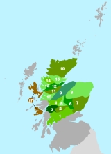
Section one: Firth of Clyde
1c. Loch Lomond to Strathyre
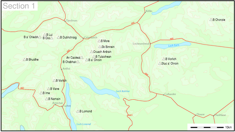
1d. Inveraray to Crianlarich
Section two: Loch Rannoch
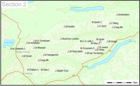
2a. Loch Rannoch to Glen Lyon
2b. Glen Lyon to Glen Dochart and Loch Tay
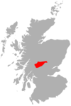
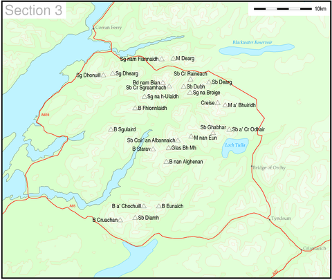
Section three: Loch Leven

3a. Loch Leven to Rannoch Station
3b. Loch Linnhe to Loch Etive
3c. Glen Etive to Glen Lochy
Section four: Fort William to Loch Ericht
4a. Fort William to Loch Treig
4b. The Mamores
4c. Loch Treig to Loch Ericht
Section five: Loch Ericht
5a. Loch Ericht to Glen Garry
5b. Glen Garry to Gaick Pass
Section six: Forest of Atholl to Braemar
6a. Glen Tromie to Glen Tilt
6b. Pitlochry to Braemar and Blairgowrie
Section seven: Braemar

Section eight: The Cairngorms

Section nine: Spean Bridge
9a. The Monadh Liath
9b. Loch Lochy to Loch Laggan
Section ten: Glen Shiel
10a. Glen Shiel to Loch Hourn and Glen Quoich
10b. Knoydart to Glen Kingie
10c. Loch Arkaig to Glen Moriston
10d. Mallaig to Fort William
Section eleven: Loch Duich
11a. Loch Duich to Cannich
11b. Glen Affric to Glen Moriston
Section twelve: Kyle of Lochalsh
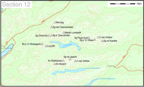

12a. Kyle of Lochalsh to Garve
12b. Killilan to Inverness
Section thirteen: Loch Carron
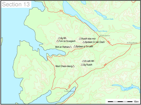

13a. Loch Torridon to Loch Maree
13b. Applecross to Achnasheen
Section fourteen: Loch Maree
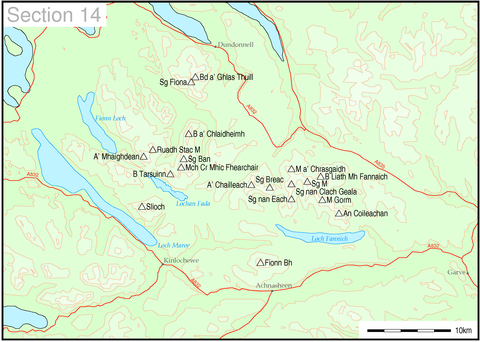

14a. Loch Maree to Loch Broom
14b. The Fannaichs
Section fifteen: Ullapool
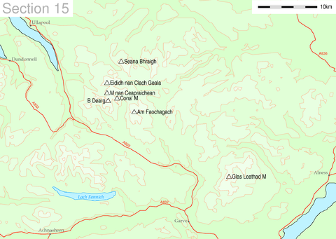
15a. Loch Broom to Strath Oykel
15b. Loch Vaich to the Moray Firth
16a. Durness to Loch Shin
16b. Altnaharra to Dornoch
16c. Scourie to Lairg
Section seventeen: Skye and Mull
Munro
A Munro is a mountain in Scotland with a height over . They are named after Sir Hugh Munro, 4th Baronet , who produced the first list of such hills, known as Munros Tables, in 1891. A Munro top is a summit over 3,000 ft which is not regarded as a separate mountain...
s, as according to the Scottish Mountaineering Club
Scottish Mountaineering Club
The Scottish Mountaineering Club is Scotland's second oldest mountaineering club. Founded in 1889, in Glasgow, the private club, with about 400 members, publishes guidebooks and runs a list of Munroists.-History:At the time of the club's founding there were a number of experienced Alpinists...
and The Munro Society. They are listed by section as used in the official tables, and in descending order of height within each section.
Hills are divided by sub-region, and hills with less than 200m relative height are indented, to give some idea of how the hills are grouped together and relate to one another.
Section one: Firth of ClydeFirth of ClydeThe Firth of Clyde forms a large area of coastal water, sheltered from the Atlantic Ocean by the Kintyre peninsula which encloses the outer firth in Argyll and Ayrshire, Scotland. The Kilbrannan Sound is a large arm of the Firth of Clyde, separating the Kintyre Peninsula from the Isle of Arran.At...
to StrathtayStrathtayStrathtay is a small rural village on the River Tay in Perthshire, Scotland. It is part of the Grandtully and Strathtay Conservation Area. Neighbouring Grandtully is situated on the other side of the Tay, across Grandtully Bridge....
| Name | Gaelic Name | Pronunciation | Translation | H | RH | Grid ref. | Parent |
|---|---|---|---|---|---|---|---|
| Ben Chonzie Ben Chonzie Ben Chonzie, also known as Ben-y Hone, is a Scottish mountain situated eleven kilometres northwest of Crieff. It stands at 931 m and is therefore listed as a Munro... |
Beinn a' Chòinnich |ˈpe ɲə ˈxɔːɲɪç |
mountain of the moss | 931 | 645 | Ben More Ben More (Crianlarich) Ben More is a mountain in the southern Highlands of Scotland, near Crianlarich. It is the highest of the so-called Crianlarich Hills to the south-east of the village, and there is no higher land in the British Isles south of Ben More... |
||
| Ben Vorlich Ben Vorlich (Loch Earn) Ben Vorlich is a mountain located in the southern part of the Highlands of Scotland. It lies in an area of land bounded to the north by Loch Earn, and to the west by Loch Lubnaig. The town of Callander lies to the south.... |
Beinn Mhùrlaig |ˈpeɲ ˈvuːrˠlˠɛkʲ |
hill of the bay | 985 | 831 | Ben More Ben More (Crianlarich) Ben More is a mountain in the southern Highlands of Scotland, near Crianlarich. It is the highest of the so-called Crianlarich Hills to the south-east of the village, and there is no higher land in the British Isles south of Ben More... |
||
| Stùc a' Chroin Stùc a' Chroin Stùc a' Chroin is a mountain located in the southern part of the Highlands of Scotland. It lies to the south of Ben Vorlich, which is itself bounded to the north by Loch Earn, and to the west by Loch Lubnaig... |
Stùc a' Chroin |ˈs̪tuːʰk ə ˈxɾɔɲ |
the peak of the danger | 975 | 252 | Ben Vorlich Ben Vorlich (Loch Earn) Ben Vorlich is a mountain located in the southern part of the Highlands of Scotland. It lies in an area of land bounded to the north by Loch Earn, and to the west by Loch Lubnaig. The town of Callander lies to the south.... |
||
| Ben More Ben More (Crianlarich) Ben More is a mountain in the southern Highlands of Scotland, near Crianlarich. It is the highest of the so-called Crianlarich Hills to the south-east of the village, and there is no higher land in the British Isles south of Ben More... |
A' Bheinn Mhòr | ə ˈveiɲ ˈvoːr | the big mountain | 1174 | 989 | Ben Nevis Ben Nevis Ben Nevis is the highest mountain in the British Isles. It is located at the western end of the Grampian Mountains in the Lochaber area of the Scottish Highlands, close to the town of Fort William.... |
|
| Stob Binnein Stob Binnein Stob Binnein is a mountain in the southern Highlands of Scotland, near Crianlarich. It forms a twin-peak with Ben More, from which it is separated by the Bealach-eadar-dha Beinn, meaning pass between two hills.... |
Stob Binnein |ˈs̪top ˈpiɲɛɲ |
conical peak | 1165 | 303 | Ben More Ben More (Crianlarich) Ben More is a mountain in the southern Highlands of Scotland, near Crianlarich. It is the highest of the so-called Crianlarich Hills to the south-east of the village, and there is no higher land in the British Isles south of Ben More... |
||
| Cruach Ardrain Cruach Ardrain Cruach Ardrain is a Munro mountain located in the southern highlands of Scotland in the Stirling Council area, five kilometres south east of Crianlarich.- Overview :... |
Cruach Àrdrain |ˈkʰɾuəx ˈaːrˠt̪ɾɛɲ |
stack of the high part | 1046 | 549 | Ben More Ben More (Crianlarich) Ben More is a mountain in the southern Highlands of Scotland, near Crianlarich. It is the highest of the so-called Crianlarich Hills to the south-east of the village, and there is no higher land in the British Isles south of Ben More... |
||
| Beinn Tulaichean Beinn Tulaichean Beinn Tulaichean is a Scottish mountain. It is not much more than the southern top of Cruach Ardrain, with a descent of only 120m before the ascent to its larger neighbour... |
Beinn Thulaichean |ˈpeɲ ˈhulˠ̪ɪçən |
mountain of hillocks | 946 | 121 | Cruach Ardrain Cruach Ardrain Cruach Ardrain is a Munro mountain located in the southern highlands of Scotland in the Stirling Council area, five kilometres south east of Crianlarich.- Overview :... |
||
| An Caisteal An Caisteal An Caisteal is a Scottish mountain situated six kilometres south of the village of Crianlarich in the Stirling Council area.- Overview :An Caisteal, which qualifies as a Munro, is located in a popular area for hill walking within a group of seven Munros and fourteen tops which stand on the eastern... |
An Caisteal | əŋ ˈkʰaʃtʲalˠ̪ | the castle | 995 | 472 | Cruach Ardrain Cruach Ardrain Cruach Ardrain is a Munro mountain located in the southern highlands of Scotland in the Stirling Council area, five kilometres south east of Crianlarich.- Overview :... |
|
1c. Loch Lomond to Strathyre
- Beinn a' ChroinBeinn a' ChroinBeinn a’ Chroin is a Scottish mountain located six kilometres south of Crianlarich in the Stirling Council area. With a height of 942 metres it qualifies as a Munro.- Overview :...
(942 m) Gaelic: Beinn a' Chroin ˈpe ɲə ˈxɾɔɲ - Ben LomondBen LomondBen Lomond , , is a distinctive mountain in the Scottish Highlands. Situated on the eastern shore of Loch Lomond, it is the most southerly of the Munros...
(974 m) Gaelic: Beinn Laomainn ˈpeɲ ˈlˠ̪ɯːmɪɲ - Beinn ChabhairBeinn ChabhairBeinn Chabhair is a Scottish mountain. It has fine views down to Loch Lomond.A common approach is from Inverarnan, up a steep eroded path beside the dramatic waterfalls of the Ben Glas Burn then finding a vague route across fairly level but very boggy moorland before walking up the hill itself and...
(933 m) Gaelic: Beinn Chabhair ˈpeɲ ˈxavɪɾʲ
1d. Inveraray to Crianlarich
- Ben LuiBen LuiBen Lui is a mountain in the southern Highlands of Scotland, at the head of Glen Fyne. It has five well-defined ridges radiating out from the summit...
(1130 m) Gaelic: Beinn Laoigh ˈpeɲ ˈlˠ̪ɤj- Beinn a' ChleibhBeinn a' ChleibhBeinn a' Chleibh is a Scottish mountain. It is linked to Ben Lui by a short ridge.-References:* The Munros, Scottish Mountaineering Trust, 1986, Donald Bennett ISBN 0-0907521-13-4...
(916 m) Gaelic: Beinn a' Chlèibh ˈpe ɲə ˈxleːv
- Beinn a' Chleibh
- Ben OssBen OssBen Oss is a Scottish mountain situated in the Stirling Council area, six kilometres south west of the village of Tyndrum within the Loch Lomond and the Trossachs National Park.- Overview :...
(1029 m) Gaelic: Beinn Ois ˈpe ˈɲɔʃ- Beinn DubhchraigBeinn DubhchraigBeinn Dubhchraig is a Scottish mountain that is situated eight kilometres west of Crianlarich in the northern part of the Loch Lomond and the Trossachs National Park.- Overview :...
(978 m) Gaelic: Beinn Dubh-chreig ˈpeɲ ˈt̪uxɾekʲ
- Beinn Dubhchraig
- Beinn ÌmeBeinn ImeBeinn Ìme is the highest mountain in the Arrochar Alps, in the Southern Highlands of Scotland. There are three usual routes of ascent. From Succoth, one may follow the same path that is used to reach The Cobbler before taking the right fork near the base of the Cobbler's main crags and continuing...
(1011 m) Gaelic: Beinn Ime ˈpe ˈɲimə - Beinn BhuidheBeinn Bhuidhe (Glen Fyne)Ben Bhuidhe is a Scottish mountain at the head of Loch Fyne.-Overview:Beinn Bhuidhe is a Munro that lies separately from the main body of the Arrochar Alps. It is an isolated mountain which, particularly when climbed in winter conditions, has a "real feeling of expedition about it"...
(948 m) Gaelic: A' Bheinn Bhuidhe ə ˈveiɲ ˈvujə - Ben VorlichBen Vorlich (Loch Lomond)Ben Vorlich is a Scottish mountain situated between the northernmost section of Loch Lomond and Loch Sloy...
(943 m) Gaelic: Beinn Mhùrlaig ˈpeɲ ˈvuːrˠlˠ̪ɛkʲ - Beinn NarnainBeinn NarnainBeinn Narnain is a mountain in the southern Highlands of Scotland, near Arrochar. It forms part of a group of hills known as the Arrochar Alps, and is a Munro. The name Beinn Narnain means "hill of notches", and describes the mountain's notched profile.Beinn Narnain is usually climbed from...
(926 m) Gaelic: Beinn Nàrnain ˈpe ˈn̪ˠaːrˠn̪ˠɛɲ - Ben VaneBen VaneBen Vane is a Scottish mountain situated in the southern Highlands. The underlying geology almost entirely comprises the Beinn Bheula Schist Formation - Psammite and Pelite with a Siluro-Devonian Dyke prominent round the northern and eastern face...
(915 m) Gaelic: A' Bheinn Mheadhain ə ˈveiɲ ˈvi.ɛɲ
Section two: Loch RannochLoch RannochLoch Rannoch is a large body of fresh water in Perth and Kinross, Scotland.The loch is over long in a west-east direction with an average width of about . The River Tummel begins at its eastern end. The Tay Forest Park lies along its southern shore...
to Loch TayLoch TayLoch Tay is a freshwater loch in the central highlands of Scotland, in the district of Perthshire.It is a long narrow loch of around 14 miles long, and typically around 1 to 1½ miles wide, following the line of the valley from the south west to north east...
2a. Loch Rannoch to Glen Lyon
- SchiehallionSchiehallionSchiehallion is a prominent mountain in Perth and Kinross, Scotland. Schiehallion has a rich botanical life, interesting archaeology, and a unique place in scientific history for an 18th-century experiment in 'weighing the world'...
(1083 m) - Beinn a' ChreachainBeinn a' ChreachainBeinn a' Chreachain is a Scottish mountain, with a conical top, to the north-west of Loch Lyon.-References:* The Munros, Scottish Mountaineering Trust, 1986, Donald Bennett ISBN 0-0907521-13-4...
(1081 m) - Beinn DorainBeinn DorainBeinn Dorain , is a mountain located in the Bridge of Orchy hills of Argyll and Bute, Scotland. It is one of the most recognisable mountains in Scotland, as it curves gracefully up from the West Highland Way...
(1076 m) - Càrn MairgCàrn MairgCàrn Mairg is a Scottish mountain located 18 km west of Aberfeldy in the Perth and Kinross council area. It stands on the northern side of Glen Lyon in a cluster of four Munros known as the Càrn Mairg group which are situated in a semi circle around the Invervar Burn.- Overview :Càrn Mairg is...
(1041 m)- Càrn GormCàrn GormCàrn Gorm is a Scottish mountain situated 22 km west of Aberfeldy in the council area of Perth and Kinross, it stands in a group of four Munros known as the Càrn Mairg group or the Glen Lyon Horseshoe on the north side of Glen Lyon.- Overview :...
(1029 m) - Meall nan AigheanMeall nan AigheanMeall nan Aighean is a Scottish mountain in the council area of Perth and Kinross. It stands in a group of four Munros known as the Càrn Mairg group or the Glen Lyon Horseshoe on the north side of Glen Lyon. It is often climbed as part of the circuit of the Càrn Mairg Munros, which stand in a...
(981 m) - Meall Garbh (Càrn Mairg Group)Meall Garbh (Càrn Mairg Group)Meall Garbh is a mountain on the north side of Glen Lyon in the Scottish Highlands. The flat summit of the hill is has two tops of almost equal height, the north-west one being considered the higher....
(968 m)
- Càrn Gorm
- Beinn AchaladairBeinn AchaladairBeinn Achaladair is a Scottish mountain situated six kilometres north east of the hamlet of Bridge of Orchy. The mountain stands on the border of the Perth and Kinross and Argyll and Bute council areas.-Overview:...
(1038 m) - Beinn an DothaidhBeinn an DothaidhBeinn an Dòthaidh , is a mountain located in the Bridge of Orchy hills of Argyll and Bute, Scotland. It is located beside the more popular Beinn Dòrain...
(1004 m) - Stuchd an LochainStuchd an LochainStuchd an Lochain is a Munro situated in the Southern Highlands of Scotland. It lies at the western end of Glen Lyon and forms the southern side of Loch an Daimh. The summit sits above a large corrie that contains a small lochan...
(960 m) - Beinn MhanachBeinn MhanachBeinn Mhanach is a Scottish mountain situated eight kilometres north-east of the hamlet of Auch.-Overview:From both the West Highland Line and the A82 road between Tyndrum and Bridge of Orchy the two rounded summits of Beinn Achaladair can be seen clearly 8km away due north-east up the Auch...
(953 m) - Meall BuidheMeall Buidhe, Glen LyonMeall Buidhe is a Munro situated in the southern highlands of Scotland. It forms the northern side of Loch an Daimh and is often climbed in conjunction with Stuchd an Lochain. The normal route climbs north from the eastern end of the loch until easier ground is reached. The route angles east and...
(932 m)
2b. Glen Lyon to Glen Dochart and Loch Tay
- Ben LawersBen LawersBen Lawers is one of the highest mountains in the southern part of the Scottish Highlands. It lies to the north side of Loch Tay, and is the highest point of a long ridge that includes seven Munros. Ben Lawers was long thought to be over 4,000 ft in height; accurate measurement in the 1870s...
(1214 m)- An StùcAn StucAn Stùc is a conically shaped Scottish mountain in the Ben Lawers range to the north of Loch Tay. The normal routes of ascent are via the ridges from Ben Lawers or Meall Garbh.-References:...
(1118 m) - Meall Garbh (Lawers Group)Meall Garbh (Lawers Group)Meall Garbh is a mountain in the southern part of the Scottish Highlands. With Meall Greigh it forms the north-eastern end of the Ben Lawers range. Its craggy south face overlooks Lochan nan Cat....
(1118 m) - Beinn GhlasBeinn GhlasBeinn Ghlas is a mountain in the Southern Highlands of Scotland. It lies on the north shore of Loch Tay and is part of the Ben Lawers Range. It lies on the popular path to Ben Lawers from the National Trust for Scotland visitor centre, with the result that many walkers traverse the summit of Beinn...
(1103 m) - Meall GreighMeall GreighMeall Greigh is a mountain in the southern part of the Scottish Highlands. With Meall Garbh it forms the north-eastern end of the Ben Lawers range....
(1001 m)
- An Stùc
- Beinn HeasgarnichBeinn HeasgarnichBeinn Heasgarnich is a Scottish mountain. It lies approximately 2 km to the south of Loch Lyon.-References:* The Munros, Scottish Mountaineering Trust, 1986, Donald Bennet ISBN 0-0907521-13-4...
(1078 m) - Meall Corranaich (1069 m)
- Meall a' Choire Leith (926 m)
- Creag MhòrCreag MhòrCreag Mhòr is a Scottish mountain which stands in the ancient Forest of Mamlorn deer forest, it is located ten kilometres north east of Tyndrum on the border between the Perth and Kinross and Stirling council areas.- Overview :...
(1047 m) - Meall nan TarmachanMeall nan TarmachanMeall nan Tarmachan is a mountain in the Southern Highlands of Scotland near Killin just west of Ben Lawers. It is often climbed as part of the Tarmachan ridge, the other peaks of which are Meall Garbh , Beinn nan Eachan and Creag na Caillach ; these three peaks are Tops rather than Munros, and...
(1044 m) - Meall GhaordaidhMeall GhaordaidhMeall Ghaordaidh is a mountain in the Southern Highlands of Scotland, approximately 10 km north-west of Killin.The mountain can be ascended via Glen Lochay starting to the north-west of the Allt Dhùin Croisg near Duncroisk, via an eroded path leading north-west through peat bogs to the summit;...
(1039 m) - Ben Challum (1025 m)
- Meall GlasMeall GlasMeall Glas is a mountain situated in the southern highlands of Scotland, it stands on the northern border of the Loch Lomond and the Trossachs National Park, some 8.5 kilometres north east of Crianlarich.- Overview :...
(959 m) - Sgiath ChuilSgiath ChuilSgiath Chùil is a mountain situated in the southern highlands of Scotland. It stands within Loch Lomond and the Trossachs National Park, on its northern border. It is approximately west of Killin.- Description :...
(921 m)
Section three: Loch LevenLoch Leven (Highlands)Loch Leven 'is a sea loch on the west coast of Scotland. It is spelled Loch Lyon in Timothy Pont's map of the areaand is pronounced Li' un. There is a Leven in Lennox and another in Glen Lyon similarly pronounced...
to Connel BridgeConnel BridgeConnel Bridge is a cantilever bridge that spans Loch Etive at Connel in Scotland. The bridge takes the A828 road across the narrowest part of the loch, at the Falls of Lora.- Construction :...
and Glen Lochy
3a. Loch Leven to Rannoch Station
- Aonach EagachAonach EagachThe Aonach Eagach is a rocky ridge lying to the north of Glen Coe in the Scottish Highlands, boasting two Munro summits.In length the full ridge continues for 10 km from the Pap of Glencoe at the west to the eastern end at the Devil's Staircase. The central section, some 2 km in length,...
- Sgor nam Fiannaidh (967 m)- Meall Dearg (953 m)
3b. Loch Linnhe to Loch Etive
- Bidean nam BianBidean nam BianBidean nam Bian, lying to the south of Glen Coe, Highland, Scotland, is the highest point in the former county of Argyll. It is a complex mountain, with many ridges and subsidiary peaks, one of which, Stob Coire Sgreamhach, is classified as a separate Munro....
(1150 m)- Stob Coire SgreamhachStob Coire SgreamhachStob Coire Sgreamhach is a mountain in Scotland, forming part of the Bidean nam Bian massif on the southern side of Glen Coe. It is often considered a subsidiary peak of Bidean, though since the 1997 revision of Munros Tables it has been classified as a separate Munro.The mountain is usually...
(1072 m)
- Stob Coire Sgreamhach
- Beinn a' BheithirBeinn a' BheithirBeinn a' Bheithir is a mountain lying to the south of Ballachulish, on the south side of Loch Leven in the Scottish Highlands. It boasts two Munro summits: the higher peak Sgorr Dhearg lies about east of Sgorr Dhonuill ....
- Sgorr Dhearg (1024 m)- Sgorr Dhonuill (1001 m)
- Buachaille Etive MòrBuachaille Etive MòrBuachaille Etive Mòr , generally known to climbers simply as The Buachaille or The Beuckle, is a mountain at the head of Glen Etive in the Highlands of Scotland...
- Stob Dearg (1021 m)- Sgor na Bròige (956 m)
- Sgor na h-Ulaidh (994 m)
- Beinn Fhionnlaidh (959 m)
- Buachaille Etive BeagBuachaille Etive BeagBuachaille Etive Beag , is a mountain located between Glen Coe and Glen Etive, on the edge of Rannoch Moor in the Scottish Highlands. Viewed from the south in Glen Etive it forms a twin with Buachaille Etive Mòr , from which it is separated by a bealach at a height of about 480 metres...
- Stob Dubh (958 m)- Stob Coire Raineach (925 m)
- Beinn SgulairdBeinn SgulairdBeinn Sgulaird is a Scottish mountain located between Glen Creran and Glen Etive in the southern highlands. It has a height of 937 m and is classed as a Munro...
(937 m)
3c. Glen Etive to Glen Lochy
- Ben CruachanBen CruachanBen Cruachan is a 1126 m mountain that is the highest point in Argyll and Bute, Scotland. It gives its name to the Cruachan Dam, a pumped-storage hydroelectric power station located in a cavern inside the mountain, as well as providing the slogan for Clan Campbell.It is the high point of a...
(1126 m)- Stob Diamh (998 m)
- Meall a' BhùiridhMeall a' BhuiridhMeall a' Bhùiridh is a mountain on the edge of Rannoch Moor in the Highlands of Scotland. It lies near the top of Glen Coe and Glen Etive, overlooking the Kings House Hotel inn and the A82 road...
(1108 m)- CreiseCreiseCreise kraysh in English, is a Scottish mountain that stands at the eastern end of Glen Coe, just to the south of the A82 road, some 26 kilometres South-southeast of Fort William in the Highland Council area...
(1100 m)
- Creise
- Stob GhabharStob GhabharStob Ghabhar is a Scottish mountain situated nine kilometres north west of Bridge of Orchy. It is part of the Black Mount group of mountains and stands on the border of the Argyll and Bute and Highland council areas.-Overview:...
(1090 m) - Ben StaravBen StaravBen Starav is a Munro mountain in the Scottish Highlands lying south of Glen Etive that rises to its full height above Loch Etive at its western foot....
(1078 m) - Stob Coir' an Albannaich (1044 m)
- Meall nan Eun (928 m)
- Glas Bheinn Mhòr (997 m)
- Beinn Eunaich (989 m)
- Beinn a' Chochuill (980 m)
- Beinn nan Aighenan (960 m)
- Stob a' Choire OdhairStob a' Choire OdhairStob a' Choire Odhair is a Scottish mountain situated eight kilometres north west of Bridge of Orchy on the border of the Argyll and Bute and Highland council areas.-Overview:...
(945 m)
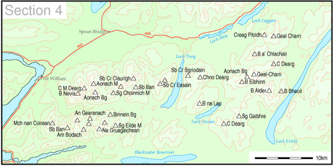
Section four: Fort William to Loch ErichtLoch ErichtLoch Ericht is a freshwater loch on the border between Perth and Kinross and the Highlands Council areas of Scotland. It is situated at a height of 351 metres above sea level and has a north-east to south-west orientation. The village of Dalwhinnie lies at the north east end of the loch...
4a. Fort William to Loch Treig
- Ben NevisBen NevisBen Nevis is the highest mountain in the British Isles. It is located at the western end of the Grampian Mountains in the Lochaber area of the Scottish Highlands, close to the town of Fort William....
(1344 m)- Càrn Mòr DeargCarn Mòr DeargCàrn Mòr Dearg is the eighth highest mountain in Scotland. It is situated in the west of Scotland, close to the town of Fort William, in Lochaber, Highland...
(1220 m)
- Càrn Mòr Dearg
- Aonach BeagAonach BeagAonach Beag is a mountain in the Highlands of Scotland. It is located about 3 km east of Ben Nevis on the north side of Glen Nevis, near the town of Fort William...
(1234 m)- Aonach MòrAonach MòrAonach Mòr is a mountain in the Highlands of Scotland. It is located about 2 miles/ 3 km north east of Ben Nevis on the south side of Glen Spean, near the town of Fort William...
(1221 m)
- Aonach Mòr
- Stob Choire ClaurighStob Choire ClaurighStob Choire Claurigh is a Scottish mountain situated east of Fort William in the Lochaber district of the Highland council area...
(1177 m)- Stob Coire an LaoighStob Coire an LaoighStob Coire an Laoigh is a Scottish mountain in The Grey Corries Range, 15 kilometres north east of Kinlochleven.At an elevation of Stob Coire an Laoigh is equal 37th in height on the Munro table.-References:...
(1116 m) - Sgurr Choinnich Mòr (1094 m)
- Stob BànStob Bàn (Grey Corries)Stob Bàn is a mountain situated in the Lochaber region of Highland, Scotland, 16 kilometres east of Fort William. It reaches a height of 977 metres and lies in a group of hills known as the Grey Corries which includes three other Munros and nine Munro "Tops" along an eight kilometre ridge...
(977 m)
- Stob Coire an Laoigh
- Stob Coire EasainStob Coire EasainStob Coire Easain is a Scottish Munro mountain which reaches a height of 1115 metres , situated 18 kilometres east of Fort William. It stands on the western side of Loch Treig, along with its "twin", the Munro Stob a' Choire Mheadhoin...
(1115 m)- Stob a' Choire MheadhoinStob a' Choire MheadhoinStob a' Choire Mheadhoin is a mountain in the Scottish Highlands, it is situated 19 km east of Fort William in the Lochaber area of the Highland council area.-Overview:...
(1105 m)
- Stob a' Choire Mheadhoin
4b. The Mamores
- Binnein MòrBinnein MòrBinnein Mòr is the highest peak in the Mamores, the range of mountains between Glen Nevis and Loch Leven in the Highlands of Scotland and lies five kilometres north north-east of Kinlochleven. The pyramidal summit of Binnein Mòr lies above the uninhabited upper section of Glen Nevis, north of the...
(1130 m)- Na GruagaicheanNa GruagaicheanNa Gruagaichean is a Scottish mountain lying between Glen Nevis to the North and the village of Kinlochleven to the South in the Mamores mountain range in the Highlands, Scotland.-Overview:...
(1056 m) - Binnein BeagBinnein BeagBinnein Beag is a Scottish mountain situated at the eastern end of the Mamores range seven kilometres north north-east of Kinlochleven. It is a relatively small, conical peak which is connected to its larger neighbour, Binnein Mòr, by a bealach at 750m. Despite being overshadowed by Binnein Mòr, it...
(943 m)
- Na Gruagaichean
- Sgurr a' MhàimSgurr a' MhàimSgurr a’ Mhàim is a Scottish mountain situated five and a half kilometres north north-west of Kinlochleven in the Lochaber region of the Highland area.- Overview :...
(1099 m)- Am BodachAm BodachAm Bodach is a Scottish mountain which lies in the Mamores range, four kilometres north of Kinlochleven in the Highland council area.- Overview :...
(1032 m) - An GearanachAn GearanachAn Gearanach is a Scottish mountain situated in the Mamore Forest, five and a half kilometres north of Kinlochleven in the Lochaber region of the Highland council area.- Overview :...
(982 m) - Stob Coire a' ChàirnStob Coire a' ChàirnStob Coire a’ Chàirn is a Scottish mountain situated in the Mamores range, 3.5 kilometres north of Kinlochleven. The mountain reaches a height of 981 metres and is regarded as one of the more modest peaks of the ten Munros in the Mamores, indeed for many years it was not named on OS maps...
(981 m)
- Am Bodach
- Sgurr Eilde MòrSgurr Eilde MòrSgurr Eilde Mòr is a Scottish mountain situated in the Mamores range, 6 kilometers north-east of Kinlochleven. It is a steep, conical peak of scree and quartzite boulders, capped with a layer of schist. With a height of 1010 m it is classed as a Munro, so is popular with hillwalkers...
(1010 m) - Stob BànStob Bàn (Mamores)Stob Bàn is a Scottish mountain situated at the western end of the Mamores ridge, five and a half kilometres north-west of Kinlochleven. With a height of 999 metres it qualifies as a Munro...
(999 m)- Mullach nan CoireanMullach nan CoireanMullach nan Coirean is a Scottish mountain situated in the Mamores group of hills. It reaches a height of 939 metres and is located eight kilometres north-west of Kinlochleven...
(939 m)
- Mullach nan Coirean
4c. Loch Treig to Loch Ericht
- Ben AlderBen AlderBen Alder is the highest mountain in the remote area of the Scottish Highlands between Loch Ericht and Glen Spean. The vast summit plateau is home of one of Britain's highest bodies of standing water, Lochan a' Garbh Coire. It is the 25th highest Munro, and due to its remote location, one of the...
(1148 m)- Beinn Bheòil (1019 m)
- Geal-ChàrnGeal-ChàrnGeal-Chàrn is a mountain in the Highlands of Scotland, 14 kilometres North East of Corrour railway station-References:...
(1132 m)- Aonach Beag (1116 m)
- Beinn Eibhinn (1102 m)
- Càrn Dearg (1034 m)
- Beinn a' Chlachair (1087 m)
- Geal Chàrn (1049 m)
- Creag Pitridh (924 m)
- Chno DeargChno DeargChno Dearg is a Scottish mountain situated 25 km east of Fort William, Highland in the Lochaber area of the Highland council area.-Overview:...
(1046 m)- Stob Coire Sgriodain (979 m)
- Sgor Gaibhre (955 m)
- Càrn Dearg (941 m)
- Beinn na Lap (937 m)
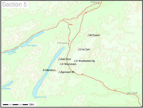
Section five: Loch ErichtLoch ErichtLoch Ericht is a freshwater loch on the border between Perth and Kinross and the Highlands Council areas of Scotland. It is situated at a height of 351 metres above sea level and has a north-east to south-west orientation. The village of Dalwhinnie lies at the north east end of the loch...
to Glen Tromie and Glen Garry
5a. Loch Ericht to Glen Garry
- Beinn UdlamainBeinn UdlamainBeinn Udlamain is a Scottish mountain which stands just to the west of the summit of the Pass of Drumochter and east of Loch Ericht, some 30 km west-northwest of the village of Blair Atholl. The mountain’s summit stands on the border between the Highland and Perth and Kinross council...
(1011 m)- Sgairneach MhòrSgairneach MhòrSgairneach Mhòr is a Scottish mountain which lies in a group of seven Munros near the summit of the Pass of Drumochter and are known as the Drumochter mountains or informerly as the “A9 Munros”...
(991 m) - Geal-chàrnGeal-ChàrnGeal-Chàrn is a mountain in the Highlands of Scotland, 14 kilometres North East of Corrour railway station-References:...
(917 m) - A' MharconaichA' MharconaichA' Mharconaich is a Scottish mountain that is located 29 km WNW of Blair Atholl in the Highland council area. It is in a group of mountains that lie west of the A9 road near the summit of the Pass of Drumochter and are known accordingly as the Drumochter Hills...
(975 m)
- Sgairneach Mhòr
5b. Glen Garry to Gaick Pass
- Meall Chuaich (951 m)
- Càrn na Caim (941 m)
- A' Bhuidheanach BheagA' Bhuidheanach BheagA' Bhuidheanach Bheag is a Scottish mountain situated on the eastern side of the Pass of Drumochter, some 24 km WNW of Blair Atholl. The mountain straddles the border between Highland and Perth and Kinross council areas although the actual summit is in the latter.-Overview:The high ground to...
(936 m)
- A' Bhuidheanach Bheag
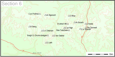
Section six: Forest of Atholl to BraemarBraemarBraemar is a village in Aberdeenshire, Scotland, around west of Aberdeen in the Highlands. It is the closest significantly-sized settlement to the upper course of the River Dee sitting at an altitude of ....
and BlairgowrieBlairgowrie and RattrayBlairgowrie and Rattray and Raitear is possibly from an English language cognate of Gaelic ràth, meaning fortress + a Pictish term cognate with Welsh tref, meaning settlement) is a twin burgh in Perth and Kinross, Scotland. Amongst locals, the town is colloquially known simply as "Blair"...
6a. Glen Tromie to Glen Tilt
- Beinn Dearg (1008 m)
- An Sgarsoch (1006 m)
- Càrn an Fhidhleir (994 m)
- Càrn a' Chlamhain (963 m)
6b. Pitlochry to Braemar and Blairgowrie
- Beinn a' Ghlò - Càrn nan Gabhar (1121 m)
- Bràigh Coire Chruinn-bhalgain (1070 m)
- Glas TulaicheanGlas TulaicheanGlas Tulaichean is a large, complex Scottish mountain located approximately south of Braemar in Perth and Kinross. It is the highest of a group of domed hills which lie in remote land between the head of Glen Tilt and Glen Shee to the east...
(1051 m) - Beinn Iutharn Mhòr (1045 m)
- Càrn Bhac (946 m)
- An Socach (944 m)
- Càrn an Rìgh (1029 m)
- Càrn Liath (975 m)
- Càrn a' GheòidhCàrn a' GheòidhCàrn a' Gheòidh is a Scottish mountain situated 15 km south of the town of Braemar. Its summit stands on the border between the council areas of Perth and Kinross and Aberdeenshire.- Overview :...
(975 m)- The CairnwellThe CairnwellThe Cairnwell is a mountain in the Eastern Highlands of Scotland, south of Braemar. It is often considered to be one of the most spoiled of the Munros, due to the Glenshee Ski Centre which covers the eastern slope of the mountain....
(933 m) - Carn AosdaCàrn AosdaCàrn Aosda is a Scottish mountain situated 12.5 km south of the town of Braemar, in the county of Aberdeenshire. It stands near the summit of the Cairnwell Pass on the A93 road, in the midst of the Glenshee Ski Centre.- Overview :...
(917 m)
- The Cairnwell
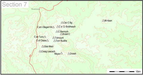
Section seven: BraemarBraemarBraemar is a village in Aberdeenshire, Scotland, around west of Aberdeen in the Highlands. It is the closest significantly-sized settlement to the upper course of the River Dee sitting at an altitude of ....
to MontroseMontrose, AngusMontrose is a coastal resort town and former royal burgh in Angus, Scotland. It is situated 38 miles north of Dundee between the mouths of the North and South Esk rivers...
- LochnagarLochnagarLochnagar or Beinn Chìochan is a mountain in the Grampians of Scotland, located about five miles south of the River Dee near Balmoral.-Names:...
(1155 m)- Càrn a' Coire Boidheach (1110 m)
- Glas MaolGlas MaolGlas Maol is the highest point in the Mounth hills, in the southeastern part of the Highlands of Scotland. The broad, flat summit is divided between the council area of Aberdeenshire, Angus and Perth and Kinross, though the highest point lies wholly within Angus; indeed Glas Maol is the highest...
(1068 m) - Cairn of Claise (1064 m)
- Càrn an t-Sagairt Mòr (1047 m)
- Càrn an Tuirc (1019 m)
- Cairn Bannoch (1012 m)
- Broad Cairn (998 m)
- Creag Leacach (987 m)
- Tolmount (958 m)
- Tom Buidhe (957 m)
- Driesh (947 m)
- Mayar (928 m)
- Mount KeenMount KeenMount Keen is a 939 m high mountain in Scotland and the most easterly Munro. It can be accessed from several directions, South from Glen Mark, North from Glen Tanar, and East to Braid Cairn. It is a moderate walk which is most popularly started by mountain bike, riding through the native...
(939 m)
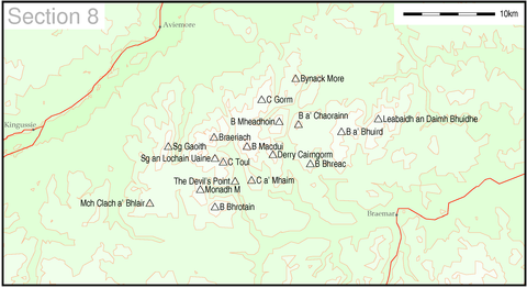
Section eight: The CairngormsCairngormsThe Cairngorms are a mountain range in the eastern Highlands of Scotland closely associated with the mountain of the same name - Cairn Gorm.-Name:...
- Ben MacduiBen Macdhui (Scotland)Ben Macdui is the second highest mountain in the United Kingdom after Ben Nevis, and the highest in the Cairngorms. After the defeat of Domnall mac Uilliam in 1187, Donnchad II, Earl of Fife, acquired Strathavon, territory stretching from Ballindalloch to Ben Macdui; because the mountain marked...
(1309 m)- Cairn GormCairn GormCairn Gorm is a mountain in the Scottish Highlands overlooking Strathspey and the town of Aviemore. At 1245 metres it is the sixth highest mountain in the United Kingdom...
(1244 m) - Derry CairngormDerry CairngormDerry Cairngorm is a Scottish mountain in the Cairngorms range, 14 kilometres north west of Braemar in the county of Aberdeenshire.- Overview :...
(1155 m)
- Cairn Gorm
- BraeriachBraeriachBraeriach is the third highest mountain in Great Britain, surpassed only by Ben Nevis and Ben Macdui. It is the highest point in the western massif of the Cairngorms, separated from the central section by the pass of the Lairig Ghru. The summit has a crescent shape, with several corries...
(1296 m)- Cairn ToulCairn ToulCairn Toul is the fourth highest mountain in Scotland, surpassed only by Ben Nevis, Ben Macdui and Braeriach...
(1291 m) - Sgor an Lochain UaineSgor an Lochain UaineSgòr an Lochain Uaine is a mountain in the Cairngorms, Scotland. By some counts it is the fifth highest mountain in Scotland . It is the third highest point in the western massif of the Cairngorms, lying between Braeriach and Cairn Toul on the western side of the pass of the Lairig Ghru...
(1258 m) - The Devil's PointThe Devil's PointThe Devil's Point is a mountain in the Cairngorms of Scotland, lying to the west of the Lairig Ghru pass. The name is derived from Gaelic, meaning "Penis of the Demon". The English name is a result of a visit to the area by Queen Victoria...
(1004 m)
- Cairn Toul
- Beinn a' BhùirdBeinn a' BhùirdBeinn a' Bhùird is a Munro in the Cairngorm mountain range of Scotland.In Watson the author suggests the mountain should be named Beinn Bòrd - table hill saying that local Scottish Gaelic speakers pronounced the mountain Paing Bòrd, with some of the older local folk still using Painna Bòrd.The...
(1197 m)- Ben AvonBen AvonBen Avon is a mountain in the Cairngorm mountains of Scotland. The highest point of the massif, known as Leabaidh an Dàimh Bhuide is classified as both a Munro and a Marilyn....
- Leabaidh an Daimh Bhuidhe (1171 m)
- Ben Avon
- Beinn MheadhoinBeinn MheadhoinBeinn Mheadhoin is a mountain in Scotland. By some counts it is the tenth highest mountain of Great Britain. It lies in the very heart of the Cairngorm mountains, and is one of the most remote hills in the region....
(1182 m) - Beinn BhrotainBeinn BhrotainBeinn Bhrotain is a Scottish mountain in the Cairngorms range, 18 kilometres west of Braemar in the county of Aberdeenshire.-References:...
(1157 m)- Monadh Mòr (1113 m)
- Sgor GaoithSgor GaoithSgòr Gaoith is a mountain in the western massif of the Cairngorms, and is separated from the Braeriach massif by the broad valley of Glen Einich. The second-highest summit of the mountain is Sgoran Dubh Mòr , which lies 1.3 km away due NNE along the summit ridge...
(1118 m)- Mullach Clach a' Bhlàir (1019 m)
- Bynack MoreBynack MoreBynack More is a Scottish Mountain that is situated in the Cairngorms range, 16 kilometres east-south-east of the town of Aviemore in the Highland region.- Overview :...
(1090 m) - Beinn a' Chaorainn (Cairngorms)Beinn a' Chaorainn (Cairngorms)Beinn a' Chaorainn is a Scottish mountain situated in the heart of the Cairngorms range. It is quite a remote hill, being located roughly 19 kilometres south east of Aviemore and 14 kilometres north west of Braemar. The mountain stands on the border of the Moray and Aberdeenshire council areas...
(1083 m)- Beinn BhreacBeinn BhreacBeinn Bhreac is a twin-peaked Scottish mountain located above Glen Derry in the Cairngorm Mountains approximately north-west of Braemar.- Overview :...
(931 m)
- Beinn Bhreac
- Càrn a' MhàimCàrn a' MhàimCàrn a' Mhàim is a Scottish mountain situated in the inner part of the Cairngorms range, some 15 kilometres west of Braemar in the county of Aberdeenshire.- Overview :...
(1037 m)
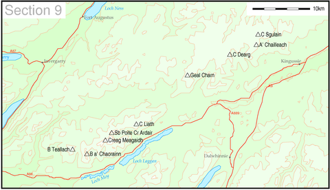
Section nine: Spean BridgeSpean BridgeSpean Bridge is a village, in the Highland region of Scotland.The village takes its name from the Highbridge over the River Spean on General Wade's military road between Fort William and Fort Augustus, and not from Telford's bridge of 1819 which carries the A82 over the river at the heart of the...
to ElginElgin, MorayElgin is a former cathedral city and Royal Burgh in Moray, Scotland. It is the administrative and commercial centre for Moray. The town originated to the south of the River Lossie on the higher ground above the flood plain. Elgin is first documented in the Cartulary of Moray in 1190...
9a. The Monadh Liath
- Càrn DeargCàrn Dearg (Monadh Liath)Càrn Dearg is the highest peak of the Monadh Liath mountains in the Highlands of Scotland. Its eastern flanks slope steeply down into Glen Ballach, while to the north, the large plateau of the Monadh Liath extends for many miles. The nearest settlements are Newtonmore and Kingussie in the Spey valley...
(945 m)- A' Chailleach (930 m)
- Geal Chàrn (926 m)
- Càrn Sgulain (920 m)
9b. Loch Lochy to Loch Laggan
- Creag MeagaidhCreag MeagaidhCreag Meagaidh is a mountain on the northern side of Glen Spean in Scotland. It is a complex mountain, taking the form of a flat summit plateau from which five ridges radiate, and is most famed for the cliffs surrounding the corrie of Coire Ardair on the north-eastern face...
(1128 m)- Stob Poite Coire Ardair (1054 m)
- Càrn Liath (1006 m)
- Beinn a' Chaorainn (Glen Spean)Beinn a' Chaorainn (Glen Spean)Beinn a’ Chaorainn is a Scottish mountain situated on the northern side of Glen Spean in the Lochaber region of the Highland Council area. The mountain which is located 30 km east-northeast of Fort William is one of several of the same name in the Scottish Highlands and should not be confused...
(1049 m) - Beinn Teallach (915 m)
Section ten: Glen ShielGlen ShielGlen Shiel is a glen in the Northwest Highlands of Scotland.The glen runs approximately 9 miles from north-west to south-east, from sea level at the village of Shiel Bridge and Loch Duich to the Cluanie Inn at the western end of Loch Cluanie and the start of Glenmoriston.W. H...
to GlenfinnanGlenfinnanGlenfinnan is a village in Lochaber area of the Highlands of Scotland. It is located at the northern end of Loch Shiel, at the foot of Glenfinnan.- Glenfinnan Monument :...
10a. Glen Shiel to Loch Hourn and Glen Quoich
- GleouraichGleouraichGleouraich is a Scottish mountain located to the north of Loch Quoich in the north western highlands. It has a height of 1035 m and is classed as a Munro...
(1035 m) - Sgurr a' MhaoraichSgurr a' MhaoraichSgurr a' Mhaoraich is a Scottish mountain located to the north of Loch Quoich in the north western highlands. It has a height of 1027 m and is classed as a Munro...
(1027 m) - Aonach air Chrith (1021 m)
- Sgurr an Doire Leathain (1010 m)
- Sgurr an Lochain (1004 m)
- Druim Shionnach (987 m)
- Maol Chinn-dearg (981 m)
- Creag a' Mhaim (947 m)
- Creag nan Damh (918 m)
- The SaddleThe SaddleThe Saddle is one of the great Scottish mountains; seen from thesite of the Battle of Glen Shiel it forms one of the best-known views in the Highlands. It is in the Highland local government area, on the boundary between the counties of Inverness-shire and Ross and Cromarty.The mountain provides...
(1010 m) - Spidean Mialach (996 m)
- Beinn SgritheallBeinn SgritheallBeinn Sgritheall is the highest mountain in the Glenelg area of the Highlands of Scotland. The main approach is via Arnisdale on the shores of Loch Hourn or via Gleann Beag to the north, with its well-known brochs...
(974 m) - Sgurr na SgineSgurr na SgineSgurr na Sgine is a Scottish mountain situated eight kilometres south of Shiel Bridge in the Glenshiel Forest at the lower end of Glen Shiel in the Highland District.- Overview :...
(946 m)
10b. Knoydart to Glen Kingie
- Sgurr na CìcheSgurr na CicheSgurr na Cìche is a mountain in the Knoydart region, in the west of Scotland. It lies on the edge of Knoydart in an area known as the Rough Bounds of Knoydart....
(1040 m)- Garbh Chioch Mhòr (1013 m)
- Ladhar BheinnLadhar BheinnLadhar Bheinn The mountain may be climbed from Barrisdale to the northeast or Inverie to the south. From Barrisdale the mountain may be climbed as part of circuit of Coire Dhorrcaill; this route involves a certain amount of scrambling, particularly on the section immediately north of the subsidiary...
(1020 m) - Sgurr Mòr (1003 m)
- Sgurr nan Coireachan (953 m)
- Meall Buidhe (946 m)
- Luinne Bheinn (939 m)
- GairichGairichGairich is a Scottish mountain situated on the southern side of Loch Quoich between Glen Kingie and Glen Garry in the Lochaber district of the Highland Council Area, 25 kilometres north-northwest of Fort William.- Overview :...
(919 m)
10c. Loch Arkaig to Glen Moriston
- Sròn a' Choire GhairbhSròn a' Choire GhairbhSròn a’ Choire Ghairbh is a Scottish mountain situated on the northern side of Loch Lochy, 13 kilometres north of Spean Bridge in the Highland Council area.-Overview:...
(937 m) - Meall na TeangaMeall na TeangaMeall na Teanga is a Scottish mountain located in the Highland council area. 11 kilometres north of Spean Bridge.- Overview :Meall na Teanga is situated on the northern side of Loch Lochy and is closely associated with the adjacent Munro of Sròn a' Choire Ghairbh which lies two kilometres to the...
(918 m)
10d. Mallaig to Fort William
- Gaor BheinnGaor BheinnGaor Bheinn, also known as Gulvain or Culvain, is a mountain in Scotland, to the north of the road west of Fort William , and south of Loch Arkaig. It is composed of banded granite and shaped like a letter Y, with two tops connected by a ridge running from northeast to southwest, with the northern...
or Gulvain (987 m) - Sgurr ThuilmSgurr ThuilmSgurr Thuilm is a mountain in the Glenfinnan area of the Highlands of Scotland. It stands at the head of Glen Finnan approximately north of Loch Shiel.-Overview:...
(963 m) - Sgurr nan Coireachan (956 m)
Section eleven: Loch DuichLoch DuichLoch Duich is a sea loch situated on the western coast of Scotland, in the Highlands.-History:In 1719, British forces burned many homesteads along the loch’s shores in the month preceding the Battle of Glen Shiel....
to Loch NessLoch NessLoch Ness is a large, deep, freshwater loch in the Scottish Highlands extending for approximately southwest of Inverness. Its surface is above sea level. Loch Ness is best known for the alleged sightings of the cryptozoological Loch Ness Monster, also known affectionately as "Nessie"...
, South of Loch MullardochLoch MullardochLoch Mullardoch is a major reservoir in Glen Cannich in the Northwest Highlands of Scotland. It was created by the damming in 1951 of the River Cannich just upstream of Mullardoch House, as part of the Affric-Beauly hydro-electric power scheme. A car park at the southern end of the dam is the...
11a. Loch Duich to Cannich
- Càrn EigeCarn EigeCàrn Eige, sometimes spelt Càrn Eighe, is the highest mountain in northern Scotland . It is in the Highland council area, on the boundary between the historic counties of Inverness and Ross and Cromarty, on the former lands of the Clan Chisholm.The mountain is very remote, more than 10 km ...
(1183 m)- Mam SodhailMam SodhailMam Sodhail, sometimes known by its anglicised name of "Mam Soul", is a Scottish Munro situated in the secluded country on the northern side of Glen Affric, some 30 kilometres east of Kyle of Lochalsh.- Overview :...
(1181 m) - Tom a' Choinich (1112 m)
- Toll Creagach (1054 m)
- Beinn FhionnlaidhBeinn Fhionnlaidh (Mullardoch)Beinn Fhionnlaidh is a mountain in the Highlands of Scotland. It is situated on the south side of Loch Mullardoch, at the end of Glen Cannich, about 60 km west of Inverness.-Ascent:...
(1005 m)
- Mam Sodhail
- Sgurr nan CeathreamhnanSgurr nan CeathreamhnanSgùrr nan Ceathreamhnan is a Scottish mountain that is situated in the remote and lonely mountainous country between Glen Affric and Glen Elchaig, some 30 kilometres east of Kyle of Lochalsh in the Highland region...
(1151 m)- Mullach na Dheireagain (982 m)
- An Socach (921 m)
- Sgurr FhuaranSgurr FhuaranSgùrr Fhuaran is a Scottish mountain that is situated on the northern side of Glen Shiel, east south east of Kyle of Lochalsh.- Overview :...
(1067 m)- Sgurr na Ciste DhuibheSgurr na Ciste DhuibheSgùrr na Ciste Duibhe is a Scottish mountain situated on the northern side of Glen Shiel, 27 kilometres south east of Kyle of Lochalsh in the Highland council area.- Overview :...
(1027 m) - Sgurr na CàrnachSgurr na CàrnachSgùrr na Càrnach is a Scottish mountain situated on the northern side of Glen Shiel, 24 kilometres south east of Kyle of Lochalsh. The mountain is part of one of the best views in the Western Highlands as it is one of three mountains which make up the Five Sisters of Kintail...
(1002 m)
- Sgurr na Ciste Dhuibhe
- Sgurr a' Bhealaich DheirgSgurr a' Bhealaich DheirgSgurr a' Bhealaich Dheirg is a Scottish mountain situated in Kintail on the northern side of Glen Shiel, 30 kilometres south east of Kyle of Lochalsh.-Overview:...
(1036 m)- Aonach MeadhoinAonach MeadhoinAonach Meadhoin is a Munro mountain situated in the Kintail region of Scotland. It stands on the northern side of Glen Shiel some 31 kilometres south east of Kyle of Lochalsh.- Overview :...
(1001 m) - SàileagSàileagSàileag is Scottish mountain located on the northern side of Glen Shiel, 27 kilometres south east of Kyle of Lochalsh.-Overview:It lies just to the east of the famous Five Sisters of Kintail group of hills to which it is connected by the Bealach an Lapain...
(956 m)
- Aonach Meadhoin
- Beinn FhadaBeinn FhadaBeinn Fhada or Ben Attow is a mountain in the Scottish Highlands.The finest route up Beinn Fhada is from Morvich to the north-west. There is a direct line up a grassy, and rather boggy slope, from the east side of the River Croe...
(1032 m) - Ciste DhubhCiste DhubhCiste Dhubh is a mountain situated in the Scottish Highlands between Glen Shiel and Glen Affric. It is a long distance from any centres of population, with Kyle of Lochalsh being almost 30 kilometres away to the west north-west.- Overview :...
(979 m) - A' Ghlas-bheinn (918 m)
11b. Glen Affric to Glen Moriston
- A' ChràlaigA' ChràlaigA' Chràlaig is a mountain in the Scottish Highlands, north of Loch Cluanie and south of Glen Affric. It is the highest peak along Glen Shiel and can be easily climbed from the Cluanie Inn on the A87...
(1120 m)- Mullach Fraoch-choire (1102 m)
- Sgurr nan Conbhairean (1109 m)
- Sail Chaorainn (1002 m)
- Càrn Ghluasaid (957 m)
Section twelve: Kyle of LochalshKyle of LochalshKyle of Lochalsh is a village on the northwest coast of Scotland, 63 miles west of Inverness. It is located at the entrance to Loch Alsh, opposite the village of Kyleakin on the Isle of Skye...
to InvernessInvernessInverness is a city in the Scottish Highlands. It is the administrative centre for the Highland council area, and is regarded as the capital of the Highlands of Scotland...
, North of Loch MullardochLoch MullardochLoch Mullardoch is a major reservoir in Glen Cannich in the Northwest Highlands of Scotland. It was created by the damming in 1951 of the River Cannich just upstream of Mullardoch House, as part of the Affric-Beauly hydro-electric power scheme. A car park at the southern end of the dam is the...
12a. Kyle of Lochalsh to Garve
- Sgurr a' Choire GhlaisSgurr a' Choire GhlaisSgurr a' Choire Ghlais is a mountain in the North-west Highlands of Scotland. It lies between Glen Strathfarrar and Glen Orrin and it is an excellent viewpoint, being the highest mountain in its group - a group which includes the Munros of Sgurr na Ruaidhe, Sgurr Fhuar-thuill and Carn nan Gobhar...
(1083 m)- Sgurr Fhuar-thuill (1049 m)
- Càrn nan Gobhar (Strathfarrar)Càrn nan Gobhar (Strathfarrar)Càrn nan Gobhar is a mountain situated on the northern side of Glen Strathfarrar in Scotland. It stands some 40 kilometres west of the city of Inverness.It is usually climbed along with the neighbouring Munros of Sgurr a' Choire Ghlais and Sgurr na Ruaidhe....
(992 m)
- Sgurr a' Chaorachain (1053 m)
- Sgurr ChoinnichSgurr ChoinnichSgurr Choinnich is a Munro in the highlands of Scotland, located in the Achnashellach Forest area between Glen Carron and Loch Monar. It is mostly a hill of steep, grassy slopes, with a narrow summit ridge that runs east/west...
(999 m)
- Sgurr Choinnich
- Maoile LunndaidhMaoile LunndaidhMaoile Lunndaidh is a Scottish mountain situated 13 km south of Achnasheen in the Ross and Cromarty district of the Highland council area...
(1007 m) - Sgurr na Ruaidhe (993 m)
- Lurg Mhòr (986 m)
- Bidein a' Choire Sheasgaich (945 m)
- MòruisgMòruisgMòruisg is a Scottish mountain situated in the Glencarron and Glenuig Forest, 10 kilometres south west of the village of Achnasheen in the Highland council area.-Overview:...
(928 m)
12b. Killilan to Inverness
- Sgurr na LapaichSgurr na LapaichSgurr na Lapaich is a mountain in the Northwest Highlands of Scotland, situated north of Loch Mullardoch in the high ground that separates Glen Cannich and Glen Strathfarrar. The mountain reaches a height of 1,150 metres , and is the fourth highest mountain north of the Great Glen...
(1150 m)- Càrn nan Gobhar (Mullardoch)Càrn nan Gobhar (Mullardoch)Càrn nan Gobhar is a Scottish mountain situated on the northern side of Loch Mullardoch in the upper part of Glen Cannich. It stands some 50 kilometres west-southwest of the city of Inverness in a remote group of four Munros informally known as “The Mullardochs” which form the high ground between...
(992 m)
- Càrn nan Gobhar (Mullardoch)
- An RiabhachanAn RiabhachanAn Riabhachan is a Scottish mountain in the Skye and Lochalsh district of the Highland council area. It is situated 35 kilometres east of Kyle of Lochalsh standing in an isolated position at the western end of Loch Mullardoch, ten kilometres from any public road.- Overview :An Riabhachan reaches a...
(1129 m) - An Socach (1069 m)
Section thirteen: Loch CarronLoch CarronLoch Carron is a sea loch on the west coast of Ross and Cromarty in the Scottish Highlands. It is the point at which the River Carron enters the North Atlantic Ocean....
to Loch MareeLoch MareeLoch Maree is a loch in Wester Ross in the Northwest Highlands of Scotland. At long and with a maximum width of , it is the fourth largest freshwater loch in Scotland; it is the largest north of Loch Ness. Its surface area is ....
13a. Loch Torridon to Loch Maree
- LiathachLiathachLiathach is one of the most famous of the Torridon Hills. It lies to the north of the A896 road, in the Northwest Highlands of Scotland, and has two peaks of Munro status: Spidean a' Choire Leith at the east of the main ridge, and Mullach an Rathain at the western end of the mountain...
- Spidean a' Choire Leith (1055 m)- Mullach an Rathain (1023 m)
- Beinn EigheBeinn EigheBeinn Eighe is a complex mountain massif in the Torridon area of the Highlands of Scotland. It forms a long ridge with many spurs and summits, two of which are classified as Munros. The name Beinn Eighe comes from the Scottish Gaelic meaning File Mountain...
- Ruadh-stac Mòr (1010 m)- Spidean Coire nan Clach (993 m)
- Beinn AlliginBeinn AlliginBeinn Alligin one of the classic mountains of the Torridon region of Scotland, lying to the north of Loch Torridon, in the Highlands. The name Beinn Alligin is from the Scottish Gaelic, meaning Jewelled Hill...
- Sgurr Mhòr (986 m)- Tom na Gruagaich (922 m)
13b. Applecross to Achnasheen
- Sgorr RuadhSgorr RuadhSgorr Ruadh is a mountain situated in the mountainous area between Strath Carron and Glen Torridon in Wester Ross in the Highland Region of Scotland...
(962 m) - Maol Chean-dearg (933 m)
- Beinn Liath MhòrBeinn Liath MhòrBeinn Liath Mhòr is a Scottish mountain situated in the mountainous area between Strath Carron and Glen Torridon in Wester Ross in the Highland region. Geologically Beinn Liath Mhòr is made up of Cambrian quartzite scree and Torridonian sandstones giving the mountain a distinctive colour contrast...
(926 m)
Section fourteen: Loch MareeLoch MareeLoch Maree is a loch in Wester Ross in the Northwest Highlands of Scotland. At long and with a maximum width of , it is the fourth largest freshwater loch in Scotland; it is the largest north of Loch Ness. Its surface area is ....
to Loch BroomLoch BroomLoch Broom is a sea loch located in northwestern Ross and Cromarty, in the former parish of Lochbroom, in the west coast of Scotland. The small town of Ullapool lies on the eastern shore of the loch...
and GarveGarveGarve is a village on the Black Water river, in Ross-shire, and is in the Highland Council area of Scotland. It is situated 5 miles northwest of Contin, on the A835, the main road to Ullapool on the west coast, close to where the A832 branches off towards Achnasheen.The village is served by the...
14a. Loch Maree to Loch Broom
- An TeallachAn TeallachAn Teallach is a mountain in Scotland. It lies to the southwest of Dundonnell and overlooks Little Loch Broom, in an area often nicknamed the "great wilderness"...
- Bidein a' Ghlas Thuill (1062 m)- Sgurr Fiona (1060 m)
- Mullach Coire Mhic Fhearchair (1018 m)
- Sgurr Bàn (989 m)
- SliochSliochSlioch is a mountain in the Scottish Highlands situated in Wester Ross, eight kilometres north of the village of Kinlochewe. Slioch reaches a height of 981 metres and towers above the south east end of Loch Maree to give one of the best known and most photographed sights in the Highlands...
(981 m) - A' MhaighdeanA' MhaighdeanA' Mhaighdean is one of the least accessible of the munros in northern Scotland. It is 8 miles North of Kinlochewe but most easily accessible from Poolewe, taking a private road South East to Kernsary. A good track then leads to the causeway between the Fionn Loch and Loch Dubh...
(967 m)- Ruadh Stac Mòr (918 m)
- Beinn Tarsuinn (937 m)
- Beinn a' Chlaidheimh (916 m)
14b. The Fannaichs
- Sgurr MòrSgurr Mòr (Fannichs)Sgurr Mòr is the highest of the nine Munros in the mountain range known as the Fannichs in northern Scotland. This range is located between Loch Fannich and the A835 Ullapool road — a remote area with few habitations, but these Munros, which are usually climbed in groups or occasionally in a single...
(1110 m)- Beinn Liath Mhòr Fannaich (954 m)
- Meall Gorm (949 m)
- Meall a' ChrasgaidhMeall a' ChrasgaidhMeall a' Chrasgaidh is a Scottish mountain located in the Fannich group of mountains, 21 kilometres south-southeast of Ullapool.- Overview :The mountain is centrally located within the Fannichs and is one of the most accessible of the group with the A832 and A835 roads running just to the north...
(934 m) - An Coileachan (923 m)
- Sgurr nan Clach GealaSgurr nan Clach GealaSgurr nan Clach Geala is a Scottish mountain situated 28 kilometres south-southeast of Ullapool in the county of Ross and Cromarty in the Highland council area...
(1093 m)- Sgurr nan EachSgurr nan EachSgurr nan Each is a Scottish mountain situated in the group of hills known as the Fannichs. It is south of Ullapool in the Ross and Cromarty district of the Highland council area.-Overview:...
(923 m)
- Sgurr nan Each
- Sgurr Breac (999 m)
- A' Chailleach (997 m)
- Fionn BheinnFionn BheinnFionn Bheinn is a Scottish mountain located south of Loch Fannich in the north western highlands. It has a height of 933 m and is listed as a Munro...
(933 m)
Section fifteen: UllapoolUllapoolUllapool is a small town of around 1,300 inhabitants in Ross and Cromarty, Highland, Scotland. Despite its small size, it is the largest settlement for many miles around, and is a major tourist destination of Scotland. The North Atlantic Drift passes by Ullapool, bringing moderate temperatures...
to the Moray FirthMoray FirthThe Moray Firth is a roughly triangular inlet of the North Sea, north and east of Inverness, which is in the Highland council area of north of Scotland...
15a. Loch Broom to Strath Oykel
- Beinn DeargBeinn Dearg (Ullapool)Beinn Dearg is a mountain in the Inverlael area of the Highlands of Scotland. It is most frequently climbed by following the River Lael up Gleann na Sguaib. Starting from near the head of Loch Broom a path follows the glen to a bealach about a kilometre north of the summit...
(1084 m)- Cona' Mheall (978 m)
- Meall nan Ceapraichean (977 m)
- Eididh nan Clach Geala (927 m)
- Am Faochagach (953 m)
- Seana BhràighSeana BhràighSeana Bhràigh is a mountain east of Ullapool, in the Highlands of Scotland.-Ascent:The main approach is from the A835 road through the Lael Forest then over the Coire an Lochain Sgeirich ridge at the head of Gleann a' Mhadaidh. The base of the hill is then reached across pathless boggy terrain,...
(926 m)
15b. Loch Vaich to the Moray Firth
- Ben WyvisBen WyvisBen Wyvis is a mountain located in Easter Ross, Ross and Cromarty, Highland, in northern Scotland, north-west of Dingwall. It forms an undulating ridge running roughly north-south for about 5 km, the highest summit of which is Glas Leathad Mòr...
- Glas Leathad Mòr (1046 m)
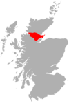
Section sixteen: The Far North
16a. Durness to Loch Shin
- Ben HopeBen HopeBen Hope is a mountain in northern Scotland. It is the most northerly Munro, standing alone in the Flow Country south-east of Loch Hope in Sutherland. The mountain is a roughly triangular wedge, with a great crag on the west, with two lower shoulders to the south and northeast...
(927 m)
16b. Altnaharra to Dornoch
- Ben Klibreck - Meall nan ConBen KlibreckBen Klibreck is a Scottish mountain located in central Sutherland. It is an isolated hill, rising above a large area of moorland. The highest point, Meall nan Con, rises to 962 m and is therefore the second most northerly Munro after Ben Hope...
(962 m)
16c. Scourie to Lairg
- Ben More AssyntBen More AssyntBen More Assynt is a mountain in Assynt in the far north-west of Scotland, north-north-east of the town of Ullapool...
(998 m)- ConivalConivalConival is a Scottish mountain situated in Assynt in the Sutherland area of the Highland Council Area, 30 kilometres north-northeast of the town of Ullapool.- Overview :...
(987 m)
- Conival
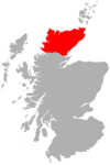
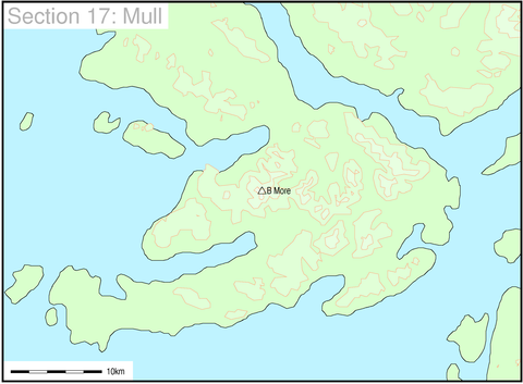
Section seventeen: Skye and MullIsle of MullThe Isle of Mull or simply Mull is the second largest island of the Inner Hebrides, off the west coast of Scotland in the council area of Argyll and Bute....
 17a. Skye Cuillin
17b. Mull
|
  |