
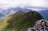
An Gearanach
Encyclopedia
Scotland
Scotland is a country that is part of the United Kingdom. Occupying the northern third of the island of Great Britain, it shares a border with England to the south and is bounded by the North Sea to the east, the Atlantic Ocean to the north and west, and the North Channel and Irish Sea to the...
mountain
Mountain
Image:Himalaya_annotated.jpg|thumb|right|The Himalayan mountain range with Mount Everestrect 58 14 160 49 Chomo Lonzorect 200 28 335 52 Makalurect 378 24 566 45 Mount Everestrect 188 581 920 656 Tibetan Plateaurect 250 406 340 427 Rong River...
situated in the Mamore Forest, five and a half kilometres north of Kinlochleven
Kinlochleven
Kinlochleven is a village in Lochaber, in the Scottish Highlands and lies at the eastern end of Loch Leven, a sea loch cutting into the western Scottish Highlands. To the north lie the Mamores ridge; to the south lie the mountains flanking Glen Coe...
in the Lochaber
Lochaber
District of Lochaber 1975 to 1996Highland council area shown as one of the council areas of ScotlandLochaber is one of the 16 ward management areas of the Highland Council of Scotland and one of eight former local government districts of the two-tier Highland region...
region of the Highland
Highland (council area)
Highland is a council area in the Scottish Highlands and is the largest local government area in both Scotland and the United Kingdom as a whole. It shares borders with the council areas of Moray, Aberdeenshire, Perth and Kinross, and Argyll and Bute. Their councils, and those of Angus and...
council area.
Overview
An Gearanach reaches a height of 982 metres (3222 feet) making it MunroMunro
A Munro is a mountain in Scotland with a height over . They are named after Sir Hugh Munro, 4th Baronet , who produced the first list of such hills, known as Munros Tables, in 1891. A Munro top is a summit over 3,000 ft which is not regarded as a separate mountain...
number 167 in height order and with a prominence
Topographic prominence
In topography, prominence, also known as autonomous height, relative height, shoulder drop , or prime factor , categorizes the height of the mountain's or hill's summit by the elevation between it and the lowest contour line encircling it and no higher summit...
of 151 metres it just qualifies as a Marilyn
Marilyn (hill)
A Marilyn is a mountain or hill in the United Kingdom, Republic of Ireland or Isle of Man with a relative height of at least 150 metres , regardless of absolute height or other merit...
. It is part of a group of mountains commonly called the Mamores
Mamores
The Mamores are a group of mountains in the Lochaber area of the Grampian Mountains in the Scottish Highlands. They form an east-west ridge approximately fifteen kilometres in length lying between Glen Nevis to the north and Loch Leven to the south....
which lie between Loch Leven
Loch Leven (Highlands)
Loch Leven 'is a sea loch on the west coast of Scotland. It is spelled Loch Lyon in Timothy Pont's map of the areaand is pronounced Li' un. There is a Leven in Lennox and another in Glen Lyon similarly pronounced...
and Glen Nevis
Glen Nevis
Glen Nevis is a glen in Lochaber, Highland, Scotland, with Fort William at its foot. It is bordered to the south by the Mamore range, and to the north by the highest mountains in the British Isles: Ben Nevis, Càrn Mor Dearg, Aonach Mòr, and Aonach Beag...
and consist of 10 Munros and two Corbetts. The translation of the mountains name from Gaelic
Scottish Gaelic language
Scottish Gaelic is a Celtic language native to Scotland. A member of the Goidelic branch of the Celtic languages, Scottish Gaelic, like Modern Irish and Manx, developed out of Middle Irish, and thus descends ultimately from Primitive Irish....
is uncertain with some publications giving it as "short ridge" from Gearr Aonach while others give a translated name of "the complainer" or "the sad place".
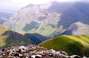
Geography
The upper slopes of An Gearanach are basically a north-south summit ridge just over a kilometre in length with steep flanks which drop into the valleys of the Allt Coire a' Mhail to the west and the Allt Coire na Gabhalach to the east. At the northern end of the mountain are three ridges which go roughly NW, north and NE descending to upper Glen Nevis. To the south is a ridge which descends to the BealachMountain pass
A mountain pass is a route through a mountain range or over a ridge. If following the lowest possible route, a pass is locally the highest point on that route...
a' Chadah (857 metres) before continuing to the adjoining Munro of Stob Coire a' Chàirn
Stob Coire a' Chàirn
Stob Coire a’ Chàirn is a Scottish mountain situated in the Mamores range, 3.5 kilometres north of Kinlochleven. The mountain reaches a height of 981 metres and is regarded as one of the more modest peaks of the ten Munros in the Mamores, indeed for many years it was not named on OS maps...
. An Gearanach is a popular mountain, not just because of its Munro status but because it is part of one of the best and most exposed ridge walks in the whole of Scotland, the Ring of Steall. This route takes in the three other Munros of Stob Coire a' Chàirn, Am Bodach
Am Bodach
Am Bodach is a Scottish mountain which lies in the Mamores range, four kilometres north of Kinlochleven in the Highland council area.- Overview :...
and Sgurr a' Mhàim
Sgurr a' Mhàim
Sgurr a’ Mhàim is a Scottish mountain situated five and a half kilometres north north-west of Kinlochleven in the Lochaber region of the Highland area.- Overview :...
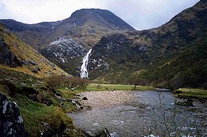
during a circuit of the Allt Coire a' Mhàil, a valley which feeds the An Steall Ban waterfall. The An Steall Bàn ("the white spout") is a fine sight as it drops 120 metres down the northern lower slopes of An Gearanach. The base of the falls is passed on the approach to the mountain from Glen Nevis.
An Gearanach has a subsidiary peak, An Garbhanach ("rough ridge"), which lies 400 metres to the south: the two are connected by a narrow ridge which at one point is quite tricky as it tapers to a knife edge arête
Arete
Areté is the term meaning "virtue" or "excellence", from Greek ἈρετήArete may also be used:*as a given name of persons or things:**Queen Arete , a character in Homer's Odyssey.***197 Arete, an asteroid....
dropping into deep glens on either side and requires a good head for heights. There has always been some uncertaincy about which is the highest point, with both An Gearanach and An Garbhanach given a height of 3,200 feet on pre metric maps in the 1970s. An Garbhanach reaches a height of 975 metres and in 1921 was accidentally elevated to Munro status and An Gearanach reduced to a "top" due to the vagaries of old fashioned mapping techniques. The mistake was rectified in the 1933 revision of Munro's tables with an explanation that it had all been a mistake. The northern slopes of An Gearanach require some care when descending from the mountain to Glen Nevis and there have been fatalities as walkers have left the stalkers
Game stalker
Defined narrowly, a game stalker is a hunter who for sport, approaches close to its timid quarry before making a kill. The practice is commonly associated with the moors of Scotland where the principal quarry is red deer. However, the skill is found worldwide and is of extremely long standing...
path and tried to descend directly to Glen Nevis and got into difficulties on the crags above the An Steall Ban waterfall.
Ascents
An Gearanach can be climbed from either Glen Nevis or KinlochlevenKinlochleven
Kinlochleven is a village in Lochaber, in the Scottish Highlands and lies at the eastern end of Loch Leven, a sea loch cutting into the western Scottish Highlands. To the north lie the Mamores ridge; to the south lie the mountains flanking Glen Coe...
. The approach from Glen Nevis is shorter and has the advantage of approaching through the lovely Nevis gorge and past the foot of the An Steall Ban waterfall. After crossing the Water of Nevis on a wire suspension bridge and passing the foot of the waterfall, a stalkers path zig zags up the hillside to gain the NNE ridge and up to the summit. The approach from Kinlochleven involves firstly ascending Stob Coire a' Chàirn by the stalkers' path up Coire na Ba before continuing to An Gearanach giving an out and back trip of 14 kilometres.