
Loch Ness
Encyclopedia
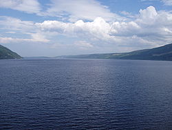
Loch Ness is a large, deep, freshwater loch
Loch
Loch is the Irish and Scottish Gaelic word for a lake or a sea inlet. It has been anglicised as lough, although this is pronounced the same way as loch. Some lochs could also be called a firth, fjord, estuary, strait or bay...
in the Scottish Highlands
Scottish Highlands
The Highlands is an historic region of Scotland. The area is sometimes referred to as the "Scottish Highlands". It was culturally distinguishable from the Lowlands from the later Middle Ages into the modern period, when Lowland Scots replaced Scottish Gaelic throughout most of the Lowlands...
(57°18′N 4°27′W) extending for approximately 37 km (23 mi) southwest of Inverness
Inverness
Inverness is a city in the Scottish Highlands. It is the administrative centre for the Highland council area, and is regarded as the capital of the Highlands of Scotland...
. Its surface is 15.8 m (51.8 ft) above sea level. Loch Ness is best known for the alleged sightings of the cryptozoological
Cryptid
In cryptozoology and sometimes in cryptobotany, a cryptid is a creature or plant whose existence has been suggested but is unrecognized by scientific consensus and often regarded as highly unlikely. Famous examples include the Yeti in the Himalayas and the Loch Ness Monster in...
Loch Ness Monster
Loch Ness Monster
The Loch Ness Monster is a cryptid that is reputed to inhabit Loch Ness in the Scottish Highlands. It is similar to other supposed lake monsters in Scotland and elsewhere, though its description varies from one account to the next....
, also known affectionately as "Nessie". It is connected at the southern end by the River Oich and a section of the Caledonian Canal
Caledonian Canal
The Caledonian Canal is a canal in Scotland that connects the Scottish east coast at Inverness with the west coast at Corpach near Fort William. It was constructed in the early nineteenth century by engineer Thomas Telford, and is a sister canal of the Göta Canal in Sweden, also constructed by...
to Loch Oich
Loch Oich
Loch Oich is a freshwater loch in the Highlands of Scotland which forms part of the Caledonian Canal, of which it is the highest point. This narrow loch lies between Loch Ness and Loch Lochy in the Great Glen...
. At the northern end there is the Bona Narrows
Narrows
Narrows is a term for restricted land or water passages. Most commonly it refers to a strait, though it can also refer to a water gap....
which opens out into Loch Dochfour, which feeds the River Ness
River Ness
The River Ness is a river flowing from Loch Ness in Scotland, north to Inverness and the Moray Firth. On a hill above the river in Inverness stands Inverness Castle. The river is overlooked by the Eden Court Theatre, one of the largest theatres in Scotland. St. Andrews Cathedral also lies along...
and a further section of canal to Inverness
Inverness
Inverness is a city in the Scottish Highlands. It is the administrative centre for the Highland council area, and is regarded as the capital of the Highlands of Scotland...
. It is one of a series of interconnected, murky bodies of water in Scotland
Scotland
Scotland is a country that is part of the United Kingdom. Occupying the northern third of the island of Great Britain, it shares a border with England to the south and is bounded by the North Sea to the east, the Atlantic Ocean to the north and west, and the North Channel and Irish Sea to the...
; its water visibility is exceptionally low due to a high peat
Peat
Peat is an accumulation of partially decayed vegetation matter or histosol. Peat forms in wetland bogs, moors, muskegs, pocosins, mires, and peat swamp forests. Peat is harvested as an important source of fuel in certain parts of the world...
content in the surrounding soil.
Loch Ness is the second largest Scottish loch by surface area at 56.4 km² (21.8 sq mi) after Loch Lomond
Loch Lomond
Loch Lomond is a freshwater Scottish loch, lying on the Highland Boundary Fault. It is the largest lake in Great Britain by surface area. The lake contains many islands, including Inchmurrin, the largest fresh-water island in the British Isles, although the lake itself is smaller than many Irish...
, but due to its great depth, it is the largest by volume. Its deepest point is 230 m (755 ft), deeper than the height of London's BT Tower
BT Tower
The BT Tower is a tall cylindrical building in London, United Kingdom, located at 60 Cleveland Street, Fitzrovia W1T 4JZ, London Borough of Camden. It has been previously known as the Post Office Tower, the London Telecom Tower and the British Telecom Tower. The main structure is tall, with a...
at 189 m (620.1 ft) and deeper than any other loch except Loch Morar
Loch Morar
Loch Morar is a freshwater loch in Morar, Lochaber, Highland, Scotland. It is the fifth-largest loch in Scotland, with a surface area of and the deepest freshwater body in the British Isles, with a maximum depth of ....
. It contains more fresh water than all the lakes in England and Wales combined, and is the largest body of water on the Great Glen Fault
Great Glen Fault
The Great Glen Fault is a long strike-slip fault that runs through its namesake the Great Glen in Scotland. However, the fault is actually much longer and over 400 million years old.-Location:...
, which runs from Inverness in the north to Fort William
Fort William, Scotland
Fort William is the second largest settlement in the highlands of Scotland and the largest town: only the city of Inverness is larger.Fort William is a major tourist centre with Glen Coe just to the south, Aonach Mòr to the north and Glenfinnan to the west, on the Road to the Isles...
in the south.
Villages and places
| North |
|
|
|---|---|---|
| Shores | Western | Eastern |
|
Abriachan Abriachan , pronounced with the stress on the i , is a village in the Highland council area of Scotland. It is situated high above the western shore of Loch Ness, 15 km to the south-west of the city of Inverness. The village has a population of approximately 120... Drumnadrochit Drumnadrochit is a village inthe Highland local government council area of Scotland, lying on the west shore of Loch Ness, at the foot of Glen Urquhart.-History:... Urquhart Castle Urquhart Castle sits beside Loch Ness in Scotland along the A82 road, between Fort William and Inverness. It is close to the village of Drumnadrochit. Though extensively ruined, it was in its day one of the largest strongholds of medieval Scotland, and remains an impressive structure, splendidly... Invermoriston Invermoriston is a small village 7 miles north of Fort Augustus, Highland, Scotland. The village is on the A82 road, at a junction with the A887. The village's most visited attraction is the Thomas Telford bridge, built in 1813, which crosses the spectacular River Moriston falls... |
Dores Dores is a village located on the south shore of Loch Ness, 10 km south west of the city of Inverness, in the Highland council area of Scotland.The annual RockNess music festival takes place in fields to the north of the village.... Inverfarigaig Inverfarigaig is a hamlet at the mouth of the River Farigaig, on the south east shore of Loch Ness in Inverness-shire, Scottish Highlands and is in the Scottish council area of Highland.The villages of Bunloit and Balbeg are directly across Loch Ness.... Foyers Foyers is the name of a village in the Highland local government council area of Scotland, lying on the east shore of Loch Ness... Whitebridge, Scotland Whitebridge is a small village on the southeast side of Loch Ness in northern Scotland. It is roughly 25 miles from Inverness and eight miles from Fort Augustus. Whitebridge is home to fewer than 100 people spread over roughly 5 miles. It is a very popular tourist destination. Most of the... |
|
| South |
Fort Augustus Fort Augustus is a settlement in the Scottish Highlands, at the south west end of Loch Ness. The village has a population of around 646 ; its economy is heavily reliant on tourism.... |
|
At Drumnadrochit
Drumnadrochit
Drumnadrochit is a village inthe Highland local government council area of Scotland, lying on the west shore of Loch Ness, at the foot of Glen Urquhart.-History:...
is "The Loch Ness Centre" which examines the natural history and legend of Loch Ness. Boat cruises operate from various locations on the loch shore, giving visitors the chance to look for the "monster
Loch Ness Monster
The Loch Ness Monster is a cryptid that is reputed to inhabit Loch Ness in the Scottish Highlands. It is similar to other supposed lake monsters in Scotland and elsewhere, though its description varies from one account to the next....
".
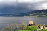
Urquhart Castle
Urquhart Castle
Urquhart Castle sits beside Loch Ness in Scotland along the A82 road, between Fort William and Inverness. It is close to the village of Drumnadrochit. Though extensively ruined, it was in its day one of the largest strongholds of medieval Scotland, and remains an impressive structure, splendidly...
is located on the Western shore, 1 miles (1.6 km) east of Drumnadrochit.
Lighthouses
Lighthouses in Scotland
This is a list of lighthouses in Scotland. The Northern Lighthouse Board are responsible for many lighthouses in Scotland.-Argyll and Bute:*Ardencaple Castle*Cloch Point Lighthouse*Dubh Artach Lighthouse*Rinns of Islay Lighthouse, Orsay...
are located at Lochend (Bona Lighthouse) and Fort Augustus.
Fish species
| European eel European eel The European eel, Anguilla anguilla, is a species of eel, a snake-like, catadromous fish. They can reach in exceptional cases a length of 1½ m, but are normally much smaller, about 60–80 cm, and rarely more than 1 m.... |
Anguilla anguilla |
| Pike Esox Esox is a genus of freshwater fish, the only living genus in the family Esocidae — the esocids which were endemic to North America, Europe and Eurasia during the Paleogene through present.The type species is E. lucius, the northern pike... |
Esox lucius |
| Three-spined stickleback Three-spined stickleback The three-spined stickleback, Gasterosteus aculeatus, is a fish native to much of northern Europe, northern Asia and North America. It has been introduced into parts of southern and central Europe.-Distribution and morphological variation:... |
Gasterosteus aculeatus |
| Brook lamprey Brook lamprey The European brook lamprey is a small European lamprey species that exclusively inhabits freshwater... |
Lampetra planeri |
| Eurasian minnow Eurasian minnow The Common minnow is a species offreshwater fish. It is a member of the carpfamily oforder Cypriniformes, and is the type species ofgenus Phoxinus. It is ubiquitous throughout much of Eurasia,... |
Phoxinus phoxinus |
| Atlantic salmon Atlantic salmon The Atlantic salmon is a species of fish in the family Salmonidae, which is found in the northern Atlantic Ocean and in rivers that flow into the north Atlantic and the north Pacific.... |
Salmo salar |
| Sea trout Brown trout The brown trout and the sea trout are fish of the same species.... |
Salmo trutta |
| Brown trout Brown trout The brown trout and the sea trout are fish of the same species.... |
Salmo trutta |
| Arctic char Arctic char Arctic char or Arctic charr is both a freshwater and saltwater fish in the Salmonidae family, native to Arctic, sub-Arctic and alpine lakes and coastal waters. No other freshwater fish is found as far north. It is the only species of fish in Lake Hazen, on Ellesmere Island in the Canadian Arctic... |
Salvelinus alpinus |
Island
The only island on Loch Ness is Cherry IslandCherry Island (Loch Ness)
Cherry Island is the only island in Loch Ness, Highland, Scotland, and is an example of a crannog. The island is about from the shore near the southern end of the loch. The island was originally by across, but is now smaller as the level of the loch was raised when it became part of the...
, visible at its southwestern end, near Fort Augustus
Fort Augustus
Fort Augustus is a settlement in the Scottish Highlands, at the south west end of Loch Ness. The village has a population of around 646 ; its economy is heavily reliant on tourism....
. It is a crannog
Crannog
A crannog is typically a partially or entirely artificial island, usually built in lakes, rivers and estuarine waters of Scotland and Ireland. Crannogs were used as dwellings over five millennia from the European Neolithic Period, to as late as the 17th/early 18th century although in Scotland,...
, which is a form of artificial island
Artificial island
An artificial island or man-made island is an island or archipelago that has been constructed by people rather than formed by natural means...
. (Most crannogs were constructed during the Iron Age
Iron Age
The Iron Age is the archaeological period generally occurring after the Bronze Age, marked by the prevalent use of iron. The early period of the age is characterized by the widespread use of iron or steel. The adoption of such material coincided with other changes in society, including differing...
.)
There was formerly a second island (Dog Island) which was submerged when the water level was raised during the construction of the Caledonian Canal
Caledonian Canal
The Caledonian Canal is a canal in Scotland that connects the Scottish east coast at Inverness with the west coast at Corpach near Fort William. It was constructed in the early nineteenth century by engineer Thomas Telford, and is a sister canal of the Göta Canal in Sweden, also constructed by...
.
Hydroelectricity
Loch Ness serves as the lower storage reservoir for the FoyersFalls of Foyers
The Fall of Foyers is a waterfall on the River Foyers, which feeds Loch Ness, in Highland, Scotland, United Kingdom....
pumped-storage
Pumped-storage hydroelectricity
Pumped-storage hydroelectricity is a type of hydroelectric power generation used by some power plants for load balancing. The method stores energy in the form of water, pumped from a lower elevation reservoir to a higher elevation. Low-cost off-peak electric power is used to run the pumps...
hydroelectric
Hydroelectricity
Hydroelectricity is the term referring to electricity generated by hydropower; the production of electrical power through the use of the gravitational force of falling or flowing water. It is the most widely used form of renewable energy...
scheme, which was the first of its kind in United Kingdom
United Kingdom
The United Kingdom of Great Britain and Northern IrelandIn the United Kingdom and Dependencies, other languages have been officially recognised as legitimate autochthonous languages under the European Charter for Regional or Minority Languages...
. The turbines were originally used to provide power for a nearby aluminium
Aluminium
Aluminium or aluminum is a silvery white member of the boron group of chemical elements. It has the symbol Al, and its atomic number is 13. It is not soluble in water under normal circumstances....
smelting
Smelting
Smelting is a form of extractive metallurgy; its main use is to produce a metal from its ore. This includes iron extraction from iron ore, and copper extraction and other base metals from their ores...
plant, but now electricity
Electricity
Electricity is a general term encompassing a variety of phenomena resulting from the presence and flow of electric charge. These include many easily recognizable phenomena, such as lightning, static electricity, and the flow of electrical current in an electrical wire...
is generated and supplied to the National Grid. Another scheme, the 100 MW Glendoe Hydro Scheme
Glendoe Hydro Scheme
The Glendoe Hydro Scheme for the generation of hydro-electric power is located near Fort Augustus, above Loch Ness in the Highlands of Scotland....
near Fort Augustus
Fort Augustus
Fort Augustus is a settlement in the Scottish Highlands, at the south west end of Loch Ness. The village has a population of around 646 ; its economy is heavily reliant on tourism....
, has recently finished construction and began generation in June 2009 producing 76 gigawatt hours in its first months of operation, but is currently out of service while awaiting repair of the tunnels connecting the reservoir to the turbines
Geology
Loch Ness lies along the Great Glen FaultGreat Glen Fault
The Great Glen Fault is a long strike-slip fault that runs through its namesake the Great Glen in Scotland. However, the fault is actually much longer and over 400 million years old.-Location:...
, which forms a line of weakness in the rocks which has been excavated by glacial erosion, forming the Great Glen
Great Glen
The Great Glen , also known as Glen Albyn or Glen More is a series of glens in Scotland running 100 kilometres from Inverness on the Moray Firth, to Fort William at the head of Loch Linnhe.The Great Glen follows a large geological fault known as the Great Glen Fault...
and the basins of Loch Lochy
Loch Lochy
Loch Lochy is a large freshwater loch in Lochaber, Highland, Scotland. With a mean depth of , it is the third deepest loch of Scotland.-Geography:...
, Loch Oich
Loch Oich
Loch Oich is a freshwater loch in the Highlands of Scotland which forms part of the Caledonian Canal, of which it is the highest point. This narrow loch lies between Loch Ness and Loch Lochy in the Great Glen...
and Loch Ness.