
Slioch
Encyclopedia
Slioch is a mountain in the Scottish
Highlands
situated in Wester Ross
, eight kilometres north of the village of Kinlochewe
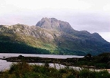
. Slioch reaches a height of 981 metres (3218 feet) and towers above the south east end of Loch Maree
to give one of the best known and most photographed sights (from the A832 road
) in the Highlands
. VisitScotland
, the Scottish national tourist agency, has used video footage of Slioch in its television advertisements.
The mountain is composed of Torridonian
sandstone
on a base of Lewisian Gneiss
and has steep crags on three sides and allows easy access for the walker only from the south east where the large open corrie
of Coire na Sleaghaich has two ridges on its flanks which the walker can utilise. The mountain's name comes from the Gaelic
word “sleagh” and means “the spear” and this only becomes obvious when Slioch is viewed from Lochan Fada to the west, from here the subsidiary top of Sgurr an Tuill Bhain (Peak of the White Hollow) (933 metres) dominates as a slender peak and gives the mountain its name. Wild goats
are often seen on the mountain.
The summit has twin pinnacles: the southern top has a trig point
with a height of 980 metres whilst the northern top is situated on the edge of the cliffs and is a finer viewpoint. In recent years it has been elevated to a height of 981 metres by the Ordnance Survey
making it the highest point on the mountain. Slioch’s isolation from other mountains makes the view from the summit top class; it takes in the wilderness of the Fisherfield Forest
to the north with its six Munros. The Torridon mountains
and Loch Maree are also well seen.
Scotland
Scotland is a country that is part of the United Kingdom. Occupying the northern third of the island of Great Britain, it shares a border with England to the south and is bounded by the North Sea to the east, the Atlantic Ocean to the north and west, and the North Channel and Irish Sea to the...
Highlands
Highland (council area)
Highland is a council area in the Scottish Highlands and is the largest local government area in both Scotland and the United Kingdom as a whole. It shares borders with the council areas of Moray, Aberdeenshire, Perth and Kinross, and Argyll and Bute. Their councils, and those of Angus and...
situated in Wester Ross
Wester Ross
is a western area of Ross and Cromarty in Scotland, notably containing the villages on the west coast such as:* Lochcarron* Applecross* Shieldaig* Torridon* Kinlochewe * * * Aultbea* Laide* Ullapool* Achiltibuie...
, eight kilometres north of the village of Kinlochewe
Kinlochewe
Kinlochewe is a village in Wester Ross in the Northwest Highlands of Scotland. It is in the parish of Gairloch, the community of Torridon and Kinlochewe and the Highland Council area. It lies near the head of Loch Maree in its magnificent valley, and serves as a junction between the main Ullapool...
. Slioch reaches a height of 981 metres (3218 feet) and towers above the south east end of Loch Maree
Loch Maree
Loch Maree is a loch in Wester Ross in the Northwest Highlands of Scotland. At long and with a maximum width of , it is the fourth largest freshwater loch in Scotland; it is the largest north of Loch Ness. Its surface area is ....
to give one of the best known and most photographed sights (from the A832 road
A832 road
The A832 is a road in the Scottish Highlands, linking Cromarty, on the east coast, to Gairloch on the west coast, and beyond Gairloch to Braemore Junction. It is long and runs entirely in the former county of Ross and Cromarty...
) in the Highlands
Scottish Highlands
The Highlands is an historic region of Scotland. The area is sometimes referred to as the "Scottish Highlands". It was culturally distinguishable from the Lowlands from the later Middle Ages into the modern period, when Lowland Scots replaced Scottish Gaelic throughout most of the Lowlands...
. VisitScotland
VisitScotland
VisitScotland is Scotland's national tourism agency. It is a public body, with offices in Edinburgh, Inverness, London as well as other parts of Scotland...
, the Scottish national tourist agency, has used video footage of Slioch in its television advertisements.
The mountain is composed of Torridonian
Torridonian
In geology, Torridonian describes a series of Neoproterozoic arenaceous sedimentary rocks, extensively developed in the Northwest Highlands of Scotland, and particularly in the district of upper Loch Torridon, a circumstance which suggested the name Torridon Sandstone, first applied to these rocks...
sandstone
Sandstone
Sandstone is a sedimentary rock composed mainly of sand-sized minerals or rock grains.Most sandstone is composed of quartz and/or feldspar because these are the most common minerals in the Earth's crust. Like sand, sandstone may be any colour, but the most common colours are tan, brown, yellow,...
on a base of Lewisian Gneiss
Lewisian complex
The Lewisian complex or Lewisian Gneiss is a suite of Precambrian metamorphic rocks that outcrop in the northwestern part of Scotland, forming part of the Hebridean Terrane. These rocks are of Archaean and Paleoproterozoic age, ranging from 3.0–1.7 Ga. They form the basement on which the...
and has steep crags on three sides and allows easy access for the walker only from the south east where the large open corrie
Cirque
Cirque may refer to:* Cirque, a geological formation* Makhtesh, an erosional landform found in the Negev desert of Israel and Sinai of Egypt*Cirque , an album by Biosphere* Cirque Corporation, a company that makes touchpads...
of Coire na Sleaghaich has two ridges on its flanks which the walker can utilise. The mountain's name comes from the Gaelic
Scottish Gaelic language
Scottish Gaelic is a Celtic language native to Scotland. A member of the Goidelic branch of the Celtic languages, Scottish Gaelic, like Modern Irish and Manx, developed out of Middle Irish, and thus descends ultimately from Primitive Irish....
word “sleagh” and means “the spear” and this only becomes obvious when Slioch is viewed from Lochan Fada to the west, from here the subsidiary top of Sgurr an Tuill Bhain (Peak of the White Hollow) (933 metres) dominates as a slender peak and gives the mountain its name. Wild goats
Wild Goat
The wild goat is a widespread species of goat, with a distribution ranging from Europe and Asia Minor to central Asia and the Middle East. It is the ancestor of the domestic goat.-Social structure:...
are often seen on the mountain.
Ascent
Slioch is climbed almost exclusively from Incheril, one kilometre east of Kinlochewe. Starting from here involves a flat five kilometre approach walk northwest along the banks of the Kinlochewe River and Loch Maree before any climbing begins. An impressive 100 metre high waterfall is passed as it comes down off Beinn a’ Mhuinidh to join the river. When the foot of Gleann Bianasdail is reached the climbing begins: it is a one kilometre walk up the glen to a path that goes left and heads for Coire na Sleaghaich and then up the south east ridge of Slioch passing two small lochans, known to many as the 'twin lochans', to reach the summit of the mountain. The return journey can be varied by taking in the subsidiary top of Sgurr an Tuill Bhain and then descending south into the corrie to join the uphill route.The summit has twin pinnacles: the southern top has a trig point
Trig point
A triangulation station, also known as a triangulation pillar, trigonometrical station, trigonometrical point, trig station, trig beacon or trig point, and sometimes informally as a trig, is a fixed surveying station, used in geodetic surveying and other surveying projects in its vicinity...
with a height of 980 metres whilst the northern top is situated on the edge of the cliffs and is a finer viewpoint. In recent years it has been elevated to a height of 981 metres by the Ordnance Survey
Ordnance Survey
Ordnance Survey , an executive agency and non-ministerial government department of the Government of the United Kingdom, is the national mapping agency for Great Britain, producing maps of Great Britain , and one of the world's largest producers of maps.The name reflects its creation together with...
making it the highest point on the mountain. Slioch’s isolation from other mountains makes the view from the summit top class; it takes in the wilderness of the Fisherfield Forest
Dundonnell and Fisherfield Forest
The Dundonnell and Fisherfield Forest covers a large mountainous area of Wester Ross in the Northwest Highlands of Scotland, lying between Loch Maree and Little Loch Broom. It is sometimes nicknamed The Great Wilderness, as the area is entirely devoid of permanent settlements.Although termed a...
to the north with its six Munros. The Torridon mountains
Torridon Hills
The Torridon Hills surround Torridon village in the Northwest Highlands of Scotland. The name is usually applied to the mountains to the north of Glen Torridon...
and Loch Maree are also well seen.