
Creise
Encyclopedia

Scotland
Scotland is a country that is part of the United Kingdom. Occupying the northern third of the island of Great Britain, it shares a border with England to the south and is bounded by the North Sea to the east, the Atlantic Ocean to the north and west, and the North Channel and Irish Sea to the...
mountain that stands at the eastern end of Glen Coe
Glen Coe
Glen Coe is a glen in the Highlands of Scotland. It lies in the southern part of the Lochaber committee area of Highland Council, and was formerly part of the county of Argyll. It is often considered one of the most spectacular and beautiful places in Scotland, and is a part of the designated...
, just to the south of the A82 road
A82 road
The A82 is a trunk road in Scotland. It is the principal route from Lowland Scotland to the western Scottish Highlands, running from Glasgow to Inverness, going by Loch Lomond, Glen Coe and Fort William. It is the second longest primary A-road in Scotland after the A9, which is the other...
, some 26 kilometres South-southeast of Fort William in the Highland
Highland (council area)
Highland is a council area in the Scottish Highlands and is the largest local government area in both Scotland and the United Kingdom as a whole. It shares borders with the council areas of Moray, Aberdeenshire, Perth and Kinross, and Argyll and Bute. Their councils, and those of Angus and...
Council area. The mountain was previously known as Clach Leathad (Stony Slope) in the Munro Tables prior to 1981, its name being changed to Creise when the highest point was found to be 1200 metres further north along the summit ridge when using new mapping techniques.
Overview
Creise along with Meall a' BhuiridhMeall a' Bhuiridh
Meall a' Bhùiridh is a mountain on the edge of Rannoch Moor in the Highlands of Scotland. It lies near the top of Glen Coe and Glen Etive, overlooking the Kings House Hotel inn and the A82 road...
, Stob Ghabhar
Stob Ghabhar
Stob Ghabhar is a Scottish mountain situated nine kilometres north west of Bridge of Orchy. It is part of the Black Mount group of mountains and stands on the border of the Argyll and Bute and Highland council areas.-Overview:...
and Stob a' Choire Odhair
Stob a' Choire Odhair
Stob a' Choire Odhair is a Scottish mountain situated eight kilometres north west of Bridge of Orchy on the border of the Argyll and Bute and Highland council areas.-Overview:...
is one of the four Black Mount Munro
Munro
A Munro is a mountain in Scotland with a height over . They are named after Sir Hugh Munro, 4th Baronet , who produced the first list of such hills, known as Munros Tables, in 1891. A Munro top is a summit over 3,000 ft which is not regarded as a separate mountain...
s, it reaches a height of 1100 metres (3609 feet) and is a hill that is well known to skiers as well as walkers being situated next to the White Corries ski area from where it is often climbed along with adjoining Meall a' Bhuiridh. The two mountains are a popular traverse with cross-country skiers
Cross-country skiing
Cross-country skiing is a winter sport in which participants propel themselves across snow-covered terrain using skis and poles...
. The mountain is well seen from the A82 road and the Kings House Hotel, showing its steep and craggy northern buttress of Sròn
Sròn
Sròn is the Scottish Gaelic word for nose and is the name of some hills in the Scottish Highlands. Before the abolition of the acute accent in Scottish Gaelic, it was sometimes spelt as srón...
na Creise. For many years the translated meaning of the mountains name from the Gaelic
Scottish Gaelic language
Scottish Gaelic is a Celtic language native to Scotland. A member of the Goidelic branch of the Celtic languages, Scottish Gaelic, like Modern Irish and Manx, developed out of Middle Irish, and thus descends ultimately from Primitive Irish....
was unknown, however Irvine Butterfield now says that “creis” means grease or fat and refers to the rich grazing land around the hill which was used in the past by Glen Coe herdsman to fatten their cattle.
Geography
Creise is a long whaleback of a mountain, oriented north to south. It has a three kilometre long summit ridge with four distinct high points. The most southerly of these top is Clach Leathad (Clachlet) which with a height of 1099 metres is just a metre shorter in elevation than the main summit. Until the early 1970s and the advent of satellite mapping it was regarded as the highest point of the mountain, it was downgraded to a “Munro Top” in the 1981 revision of the Munro Tables. 700 metres north of Clach Leathad along the ridge is Mam Coire Easain (1070 metres), a former “Munro Top” deleted from the tables in 1981, it is strategically important as it stands at the head of the ridge linking the mountain to Meall a' Bhuiridh. The main summit stands a further 650 metres north, it was previously an unnamed Munro Top on OSOrdnance Survey
Ordnance Survey , an executive agency and non-ministerial government department of the Government of the United Kingdom, is the national mapping agency for Great Britain, producing maps of Great Britain , and one of the world's largest producers of maps.The name reflects its creation together with...
maps before being upgraded to the summit of Creise in 1981.
A fourth high point is Stob a’ Ghlais Choire (996 metres), this Munro Top stands at the northern end of the ridge above the crags of Sròn na Creise which fall steeply to the valley of the River Etive. Sròn na Creise offers a challenging scramblers
Scrambling
Scrambling is a method of ascending rocky faces and ridges. It is an ambiguous term that lies somewhere between hillwalking and rock climbing. It is often distinguished from hillwalking by defining a scramble as a route where hands must be used in the ascent...
route to the summit, but needs care in winter as several serious accidents have occurred on the crags. Rainfall on Creise finds its way to both coasts of Scotland, drainage from the south of the mountain (Clach Leathad) flows into Coire Ba, one of the biggest corries in Scotland, and arrives at the east coast at the Firth of Tay
Firth of Tay
The Firth of Tay is a firth in Scotland between the council areas of Fife, Perth and Kinross, the City of Dundee and Angus, into which Scotland's largest river in terms of flow, the River Tay, empties....
via the Rivers Ba, Tummel
River Tummel
The River Tummel is a river in Perth and Kinross, Scotland. Discharging from Loch Rannoch, it flows east to a point near the Falls of Tummel, where it bends to the southeast, a direction which it maintains until it falls into the River Tay, just below Logierait, after a course of from its source...
and Tay
River Tay
The River Tay is the longest river in Scotland and the seventh-longest in the United Kingdom. The Tay originates in western Scotland on the slopes of Ben Lui , then flows easterly across the Highlands, through Loch Dochhart, Loch Lubhair and Loch Tay, then continues east through Strathtay , in...
. All other drainage from the mountain goes via Glen Etive and Loch Etive
Loch Etive
Loch Etive is a 30 km sea loch in Argyll and Bute, Scotland. It reaches the sea at Connel, 5 km north of Oban. It measures 31.6 km in length and from 1.2 km to in width...
to the west coast near Oban
Oban
Oban Oban Oban ( is a resort town within the Argyll and Bute council area of Scotland. It has a total resident population of 8,120. Despite its small size, it is the largest town between Helensburgh and Fort William and during the tourist season the town can be crowded by up to 25,000 people. Oban...
.
Ascents
The most popular ascent of Creise along with the neighbouring Meall a' Bhuiridh starts at the White Corries ski Centre (grid reference ) and climbs Meall a' Bhuiridh first by following the line of the ski chair lift (no self respecting mountaineer would use the lift). The lifts and tows go right up to the summit of the mountain. The continuation to Creise goes SW and then west over a colMountain pass
A mountain pass is a route through a mountain range or over a ridge. If following the lowest possible route, a pass is locally the highest point on that route...
with a height of 932 metres which connects the two mountains to reach the summit plateau of Creise. A direct ascent from the same starting point goes west across moorland to reach the foot of Sròn na Creise, it is then a scramblers route up to the northern end of the summit ridge. The hill can also be climbed as part of the Clachlet Traverse
Clachlet Traverse
The Clachlet Traverse is a 25 km hike over four Scottish Munro peaks, namely Stob a' Choire Odhair, Stob Ghabhar, Creise and Meall a' Bhuiridh....
, a 25 km classic walk between the Inveroran Inn at Bridge of Orchy
Bridge of Orchy
Bridge of Orchy is a landmark hamlet in Argyll, Scotland.Dating back to 1751, it includes a notable tourist hotel. Located at the head of Glen Orchy, it is on the A82 road, has a railway station and is on the West Highland Way long distance path. Nearby prominent peaks include the munros Beinn...
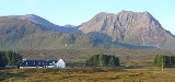
and the Kings House Inn in Glen Coe taking all four of the Black Mount Munros with 1700 metres of ascent. The view from the summit takes in a close up of the cliffs of Buachaille Etive Mòr
Buachaille Etive Mòr
Buachaille Etive Mòr , generally known to climbers simply as The Buachaille or The Beuckle, is a mountain at the head of Glen Etive in the Highlands of Scotland...
and the western part of Rannoch Moor
Rannoch Moor
Rannoch Moor is a large expanse of around 50 square miles of boggy moorland to the west of Loch Rannoch, in Perth and Kinross and Lochaber, Highland, partly northern Argyll and Bute, Scotland...