
Stob Choire Claurigh
Encyclopedia
Scotland
Scotland is a country that is part of the United Kingdom. Occupying the northern third of the island of Great Britain, it shares a border with England to the south and is bounded by the North Sea to the east, the Atlantic Ocean to the north and west, and the North Channel and Irish Sea to the...
mountain situated 16 km (10 mi) east of Fort William in the Lochaber
Lochaber
District of Lochaber 1975 to 1996Highland council area shown as one of the council areas of ScotlandLochaber is one of the 16 ward management areas of the Highland Council of Scotland and one of eight former local government districts of the two-tier Highland region...
district of the Highland
Highland (council area)
Highland is a council area in the Scottish Highlands and is the largest local government area in both Scotland and the United Kingdom as a whole. It shares borders with the council areas of Moray, Aberdeenshire, Perth and Kinross, and Argyll and Bute. Their councils, and those of Angus and...
council area. It is part of one the best ridge walks on the Scottish mainland.
Overview
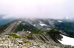
Stob Choire Claurigh stands in the Grey Corries, a group of mountains strung out along an eight km long ridge which never falls below the 800 metre (2,600 ft) contour and includes twelve summits, four of which reach MunroMunro
A Munro is a mountain in Scotland with a height over . They are named after Sir Hugh Munro, 4th Baronet , who produced the first list of such hills, known as Munros Tables, in 1891. A Munro top is a summit over 3,000 ft which is not regarded as a separate mountain...
status. Stob Choire Claurigh is the highest of the Grey Corries reaching a height of 1,177 metres (3,862 ft) making it the 15th highest Munro and the 11th highest Marilyn
Marilyn (hill)
A Marilyn is a mountain or hill in the United Kingdom, Republic of Ireland or Isle of Man with a relative height of at least 150 metres , regardless of absolute height or other merit...
in Britain. The upper part of the mountain and the main section of the ridge is composed of pale grey quartzite
Quartzite
Quartzite is a hard metamorphic rock which was originally sandstone. Sandstone is converted into quartzite through heating and pressure usually related to tectonic compression within orogenic belts. Pure quartzite is usually white to gray, though quartzites often occur in various shades of pink...
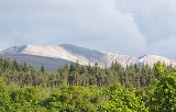
rocks and scree making an eye-catching sight which is well seen from the villages of Spean Bridge
Spean Bridge
Spean Bridge is a village, in the Highland region of Scotland.The village takes its name from the Highbridge over the River Spean on General Wade's military road between Fort William and Fort Augustus, and not from Telford's bridge of 1819 which carries the A82 over the river at the heart of the...
and Roybridge and the A86 road
A86 road
The A86 is a major road in Scotland, United Kingdom, it runs from Spean Bridge to Kingussie. It is a primary route for all of its length.Travelling along this route carries a medium to high risk of suffering a death or serious injury accident according to EuroRAP.-References:...
which runs between them. The mountains name translates from the Gaelic
Scottish Gaelic language
Scottish Gaelic is a Celtic language native to Scotland. A member of the Goidelic branch of the Celtic languages, Scottish Gaelic, like Modern Irish and Manx, developed out of Middle Irish, and thus descends ultimately from Primitive Irish....
language as “Peak of the Brawling Corrie”, taken from the verb clamhras which means clamouring or brawling. The name refers to the roaring of the many stags, which inhabit the corrie
Cirque
Cirque may refer to:* Cirque, a geological formation* Makhtesh, an erosional landform found in the Negev desert of Israel and Sinai of Egypt*Cirque , an album by Biosphere* Cirque Corporation, a company that makes touchpads...
s of the mountain in the breeding season.
Geography
Stob Choire Claurigh is a substantial mountain which includes four subsidiary tops (three of which are listed in Munros Tables), four high corries and long, forested, northern slopes which descend to the valley of the River Spean. Three main ridges radiate from the summit. The northern ridge descends for two km to the “Munro Top” of Stob Coire Gaibhre (958 metres) continuing for a further two km to the Forestry CommissionForestry Commission
The Forestry Commission is a non-ministerial government department responsible for forestry in Great Britain. Its mission is to protect and expand Britain's forests and woodlands and increase their value to society and the environment....
owned Leanachan Forest where it broadens into the Spean valley. Four hundred metres from the summit on the northern ridge is the North Top (1121 metres), at this point a spur goes east to the subsidiary summit of Stob Coire na Ceannain (1123 metres), offering easy scrambling. This eastern spur can be used as a means of ascent up rough, stony slopes from the Lairig Leachach pass
Mountain pass
A mountain pass is a route through a mountain range or over a ridge. If following the lowest possible route, a pass is locally the highest point on that route...
.
The two other ridges link to adjacent Munros, with the south ridge connecting to Stob Ban
Stob Bàn (Grey Corries)
Stob Bàn is a mountain situated in the Lochaber region of Highland, Scotland, 16 kilometres east of Fort William. It reaches a height of 977 metres and lies in a group of hills known as the Grey Corries which includes three other Munros and nine Munro "Tops" along an eight kilometre ridge...
, 1.5 km distant, over a col with a height of 803 metres. The twisting, high level SW ridge continues for three km over the “Munro Top” of Stob a’ Choire Lèith (1105 metres) to link to the Munro of Stob Coire an Laoigh. The four principal corries on the mountain are steep walled, holding snow well into the spring with streams which rise at around the 1000 metre mark, they drain in various directions but all eventually feed the River Spean, reaching the west coast at Loch Linnhe
Loch Linnhe
Loch Linnhe is a sea loch on the west coast of Scotland....
.
Ascents and view
The most popular starting point for the direct ascent of Stob Choire Claurigh is Corriechoille farm (grid reference ) at the end of the minor road from Spean Bridge. The route follows the Lairig Leacach track through a short section of the Leanachan Forest, the track is left immediately after the forest and steep slopes are climbed on the right hand side to reach the north east ridge. The ridge is followed over Stob Coire Gaibhre and along the rim of Coire na Ceannain which gives airy views down to its circular lochan, to reach the summit which is marked by a pile of quartzite boulders. There is a fine view from the top, especially to the SW where there is a fine outlook of the switchbacks and tops of the Grey Corries ridge backed by Aonach BeagAonach Beag
Aonach Beag is a mountain in the Highlands of Scotland. It is located about 3 km east of Ben Nevis on the north side of Glen Nevis, near the town of Fort William...
and Ben Nevis
Ben Nevis
Ben Nevis is the highest mountain in the British Isles. It is located at the western end of the Grampian Mountains in the Lochaber area of the Scottish Highlands, close to the town of Fort William....
. Many walkers will continue SW along the Grey Corries ridge descending eventually by the north ridge of Stob Coire an Laoigh down to the forest and eventually Corriechoille.