
Sgurr nan Clach Geala
Encyclopedia
Scotland
Scotland is a country that is part of the United Kingdom. Occupying the northern third of the island of Great Britain, it shares a border with England to the south and is bounded by the North Sea to the east, the Atlantic Ocean to the north and west, and the North Channel and Irish Sea to the...
mountain situated 28 kilometres south-southeast of Ullapool
Ullapool
Ullapool is a small town of around 1,300 inhabitants in Ross and Cromarty, Highland, Scotland. Despite its small size, it is the largest settlement for many miles around, and is a major tourist destination of Scotland. The North Atlantic Drift passes by Ullapool, bringing moderate temperatures...
in the county of Ross and Cromarty
Ross and Cromarty
Ross and Cromarty is a variously defined area in the Highlands and Islands of Scotland. There is a registration county and a lieutenancy area in current use...
in the Highland
Highland (council area)
Highland is a council area in the Scottish Highlands and is the largest local government area in both Scotland and the United Kingdom as a whole. It shares borders with the council areas of Moray, Aberdeenshire, Perth and Kinross, and Argyll and Bute. Their councils, and those of Angus and...
council area. It is one of ten Munros located in the group of hills known as the Fannichs.
Overview
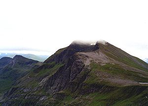
With a height of 1093 metres (3586 feet) Sgurr nan Clach Geala is the second highest of the Fannaichs behind Sgurr MòrSgurr Mòr (Fannichs)
Sgurr Mòr is the highest of the nine Munros in the mountain range known as the Fannichs in northern Scotland. This range is located between Loch Fannich and the A835 Ullapool road — a remote area with few habitations, but these Munros, which are usually climbed in groups or occasionally in a single...
and is regarded by many as the best peak of the group with its fine east facing corrie
Cirque
Cirque may refer to:* Cirque, a geological formation* Makhtesh, an erosional landform found in the Negev desert of Israel and Sinai of Egypt*Cirque , an album by Biosphere* Cirque Corporation, a company that makes touchpads...
and pointed buttresses. The hill is not easily seen from any public road being situated in the centre of the group some eight kilometres from the A832 road to the south. The best views are from nearby mountains with the eastern cliffs being seen to best effect from Sgurr Mòr across Coire Mòr. The hills name translates from the Gaelic
Scottish Gaelic language
Scottish Gaelic is a Celtic language native to Scotland. A member of the Goidelic branch of the Celtic languages, Scottish Gaelic, like Modern Irish and Manx, developed out of Middle Irish, and thus descends ultimately from Primitive Irish....
as “Peak of the White Stone”, this refers to an area of light coloured quartzite
Quartzite
Quartzite is a hard metamorphic rock which was originally sandstone. Sandstone is converted into quartzite through heating and pressure usually related to tectonic compression within orogenic belts. Pure quartzite is usually white to gray, though quartzites often occur in various shades of pink...
rocks near the summit.
Geography
Sgurr nan Clach Geala stands on a north-south ridge in the western part of the Fannichs along with two other Munros, Meall a' ChrasgaidhMeall a' Chrasgaidh
Meall a' Chrasgaidh is a Scottish mountain located in the Fannich group of mountains, 21 kilometres south-southeast of Ullapool.- Overview :The mountain is centrally located within the Fannichs and is one of the most accessible of the group with the A832 and A835 roads running just to the north...
and Sgurr nan Each
Sgurr nan Each
Sgurr nan Each is a Scottish mountain situated in the group of hills known as the Fannichs. It is south of Ullapool in the Ross and Cromarty district of the Highland council area.-Overview:...
. From a distance the mountain’s north ridge can look difficult to traverse with its craggy buttresses which can give mild scrambling if the edge of the corrie is followed, however there are no real difficulties and any problems can be easily by-passed. This northern ridge drops down to a col
Mountain pass
A mountain pass is a route through a mountain range or over a ridge. If following the lowest possible route, a pass is locally the highest point on that route...
with a height of 819 metres called Am Biachdaich (The Feeding Place), named because of the col's rich pastures where deer often feed. From the col the Munros of Meall a' Chrasgaidh and Sgurr Mòr can be climbed, a small lochan lies on the col. The southern ridge of the mountain connects to the Munro of Sgurr nan Each, which lies just under two kilometres away across a col with a height of 815 metres.
The mountains western slopes are mostly grassy with a few rocky outcrops as they drop down to the valley of the Allt Breabaig. The mountains best geological feature are its eastern cliffs, the highest in the Fannichs which fall 400 metres to the head of Coire Mòr. These Schist
Schist
The schists constitute a group of medium-grade metamorphic rocks, chiefly notable for the preponderance of lamellar minerals such as micas, chlorite, talc, hornblende, graphite, and others. Quartz often occurs in drawn-out grains to such an extent that a particular form called quartz schist is...
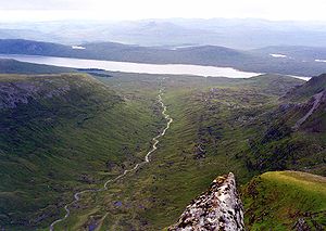
cliffs have attracted winter ice climbers with 20 named routes available, the best known being Skyscraper Buttress and Gamma Gully. Drainage from the mountain reaches both coasts of Scotland, rainfall on the west and northern slopes go via the River Broom and Loch Broom
Loch Broom
Loch Broom is a sea loch located in northwestern Ross and Cromarty, in the former parish of Lochbroom, in the west coast of Scotland. The small town of Ullapool lies on the eastern shore of the loch...
to reach the west coast at Ullapool. Drainage from the south and east flank goes south to Loch Fannich
Loch Fannich
Loch Fannich is a remote loch in Ross-shire, in the Scottish highlands. The loch is located 12 miles west of Strathpeffer.Loch Fannich was dammed and its water level raised as part of the Conon Hydro-Electric Power Scheme, built by the North of Scotland Hydro-Electric Board between 1946 and 1961...
to eventually reach the east coast at the Cromarty Firth
Cromarty Firth
The Cromarty Firth of Cromarty') is an arm of the North Sea in Scotland. It is the middle of the three sea lochs at the head of the Moray Firth: to the north lies the Dornoch Firth, and to the south the Beauly Firth....
.
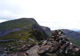
Ascents and summit
The most usual route of ascent approaches from the north starting at a parking spot on the A832 at grid reference and climbs the adjoining Munro of Meall a' Chrasgaidh before climbing Sgurr nan Clach Geala. Most walkers will continue south from the summit to take in Sgurr nan Each before returning to the starting point via the Allt Breabaig.The summit of the mountain has the remains of a trig point
Trig point
A triangulation station, also known as a triangulation pillar, trigonometrical station, trigonometrical point, trig station, trig beacon or trig point, and sometimes informally as a trig, is a fixed surveying station, used in geodetic surveying and other surveying projects in its vicinity...
, it has been vandalised and seems to have been attacked with a sledgehammer, leaving only a quarter of the pillar remaining. The eastern cliffs fall precipitously into Coire Mòr directly from the summit. The view takes in all but one of the Fannichs and is an excellent place to study the geography of the group. There is an excellent view of An Teallach
An Teallach
An Teallach is a mountain in Scotland. It lies to the southwest of Dundonnell and overlooks Little Loch Broom, in an area often nicknamed the "great wilderness"...
18 kilometres away to the north west, while the valley of the Allt a‘ Choire Mhoir looks impressive to the south as it flows down to Loch Fannich.