

Ben More (Crianlarich)
Encyclopedia
Ben More is a mountain
in the southern Highlands
of Scotland
, near Crianlarich
. It is the highest of the so-called Crianlarich Hills
to the south-east of the village, and there is no higher land in the British Isles
south of Ben More. It is separated from by the , meaning "col
between two hills".
The simplest ascent starts from Benmore Farm on the A85
. Initially one should follow the path leading up Benmore Burn, before leaving this path and heading up the northwest ridge of Ben More. The ridge is unrelentingly steep, rising 1000 metres (3,281 ft) in about 2.5 miles (4 km). The north-east ridge may prove a preferable alternative, being craggier and less steep. To reach this the walker should follow the burn
of , before striking for the ridge of once clear of the forest
ry that cloaks the lower slopes of this side of Ben More. This route is around 5 kilometres (3.1 mi) long.
Ben More is often climbed in conjunction with by descending to the and then on to the second peak. Descent may be made from the col direct to Benmore Burn.
Ben More's north side contains a long-lasting snow patch, which – uniquely in the Southern Highlands – is named on a 1:25000 Ordnance Survey
map, and is called the (crooked wreath), on account of the shape it forms in late spring/early summer. This patch frequently lasts until well into June and sometimes July. The similar name appears as a summit near Lochnagar
.
of British European Airways
took off from Glasgow International Airport
at about 2:20pm on a test flight to be conducted at Flight Level (FL) 40; in the conditions prevailing at the time FL40 was equivalent to about 3850 feet (1,173 m). At about 2:32pm the aircraft flew into Ben More about 600 feet (183 m) northeast and 100 feet (30 m) below the summit while flying in a westerly direction. The two pilots and two passengers on board were killed in the accident. The Air Accidents Investigation Branch
(AAIB) found the cause to be pilot error in a snow storm.
Mountain
Image:Himalaya_annotated.jpg|thumb|right|The Himalayan mountain range with Mount Everestrect 58 14 160 49 Chomo Lonzorect 200 28 335 52 Makalurect 378 24 566 45 Mount Everestrect 188 581 920 656 Tibetan Plateaurect 250 406 340 427 Rong River...
in the southern Highlands
Scottish Highlands
The Highlands is an historic region of Scotland. The area is sometimes referred to as the "Scottish Highlands". It was culturally distinguishable from the Lowlands from the later Middle Ages into the modern period, when Lowland Scots replaced Scottish Gaelic throughout most of the Lowlands...
of Scotland
Scotland
Scotland is a country that is part of the United Kingdom. Occupying the northern third of the island of Great Britain, it shares a border with England to the south and is bounded by the North Sea to the east, the Atlantic Ocean to the north and west, and the North Channel and Irish Sea to the...
, near Crianlarich
Crianlarich
Crianlarich is a village in the Stirling district and registration county of Perthshire, Scotland, about six miles north-east of the head of Loch Lomond...
. It is the highest of the so-called Crianlarich Hills
Crianlarich Hills
The Crianlarich Hills are a large group of mountains in Scotland, running east of Crianlarich and Loch Lomond, south of Strath Fillan and north of Loch Doine. The range is within the Breadalbane section of Loch Lomond and the Trossachs National Park and contains the highest mountains in the park...
to the south-east of the village, and there is no higher land in the British Isles
British Isles
The British Isles are a group of islands off the northwest coast of continental Europe that include the islands of Great Britain and Ireland and over six thousand smaller isles. There are two sovereign states located on the islands: the United Kingdom of Great Britain and Northern Ireland and...
south of Ben More. It is separated from by the , meaning "col
Mountain pass
A mountain pass is a route through a mountain range or over a ridge. If following the lowest possible route, a pass is locally the highest point on that route...
between two hills".
The simplest ascent starts from Benmore Farm on the A85
A85 road
The A85 is a major road in Scotland. It runs east from Oban along the south bank of Loch Etive, through Lochawe and Tyndrum, Crianlarich, Lochearnhead, St Fillans and Crieff before passing through Perth, where it crosses the River Tay via Perth Bridge. Its name between the latter two locations is...
. Initially one should follow the path leading up Benmore Burn, before leaving this path and heading up the northwest ridge of Ben More. The ridge is unrelentingly steep, rising 1000 metres (3,281 ft) in about 2.5 miles (4 km). The north-east ridge may prove a preferable alternative, being craggier and less steep. To reach this the walker should follow the burn
Stream
A stream is a body of water with a current, confined within a bed and stream banks. Depending on its locale or certain characteristics, a stream may be referred to as a branch, brook, beck, burn, creek, "crick", gill , kill, lick, rill, river, syke, bayou, rivulet, streamage, wash, run or...
of , before striking for the ridge of once clear of the forest
Forest
A forest, also referred to as a wood or the woods, is an area with a high density of trees. As with cities, depending where you are in the world, what is considered a forest may vary significantly in size and have various classification according to how and what of the forest is composed...
ry that cloaks the lower slopes of this side of Ben More. This route is around 5 kilometres (3.1 mi) long.
Ben More is often climbed in conjunction with by descending to the and then on to the second peak. Descent may be made from the col direct to Benmore Burn.
Ben More's north side contains a long-lasting snow patch, which – uniquely in the Southern Highlands – is named on a 1:25000 Ordnance Survey
Ordnance Survey
Ordnance Survey , an executive agency and non-ministerial government department of the Government of the United Kingdom, is the national mapping agency for Great Britain, producing maps of Great Britain , and one of the world's largest producers of maps.The name reflects its creation together with...
map, and is called the (crooked wreath), on account of the shape it forms in late spring/early summer. This patch frequently lasts until well into June and sometimes July. The similar name appears as a summit near Lochnagar
Lochnagar
Lochnagar or Beinn Chìochan is a mountain in the Grampians of Scotland, located about five miles south of the River Dee near Balmoral.-Names:...
.
Air crash
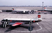
On 19 January 1973, a Vickers ViscountVickers Viscount
The Vickers Viscount was a British medium-range turboprop airliner first flown in 1948 by Vickers-Armstrongs, making it the first such aircraft to enter service in the world...
of British European Airways
British European Airways
British European Airways or British European Airways Corporation was a British airline which existed from 1946 until 1974. The airline operated European and North African routes from airports around the United Kingdom...
took off from Glasgow International Airport
Glasgow International Airport
Glasgow International Airport is an international airport in Scotland, located west of Glasgow city centre, near the towns of Paisley and Renfrew in Renfrewshire...
at about 2:20pm on a test flight to be conducted at Flight Level (FL) 40; in the conditions prevailing at the time FL40 was equivalent to about 3850 feet (1,173 m). At about 2:32pm the aircraft flew into Ben More about 600 feet (183 m) northeast and 100 feet (30 m) below the summit while flying in a westerly direction. The two pilots and two passengers on board were killed in the accident. The Air Accidents Investigation Branch
Air Accidents Investigation Branch
The Air Accidents Investigation Branch investigates air accidents in the United Kingdom. It is a branch of the Department for Transport and is based on the grounds of Farnborough Airport near Aldershot, Rushmoor, Hampshire.-History:...
(AAIB) found the cause to be pilot error in a snow storm.
External links
- Ben More (Crianlarich) is at coordinates 56.386381°N 4.539267°W
- Computer generated summit panorama (Index)