
Càrn Mairg
Encyclopedia
Scotland
Scotland is a country that is part of the United Kingdom. Occupying the northern third of the island of Great Britain, it shares a border with England to the south and is bounded by the North Sea to the east, the Atlantic Ocean to the north and west, and the North Channel and Irish Sea to the...
mountain located 18 km west of Aberfeldy
Aberfeldy, Perth and Kinross
Aberfeldy is a burgh in Perth and Kinross, Scotland, on the River Tay. A small market town, Aberfeldy is located in Highland Perthshire and houses a population of about 1,895, as of the 2001 census...
in the Perth and Kinross
Perth and Kinross
Perth and Kinross is one of 32 council areas in Scotland, and a Lieutenancy Area. It borders onto the Aberdeenshire, Angus, Dundee City, Fife, Clackmannanshire, Stirling, Argyll and Bute and Highland council areas. Perth is the administrative centre...
council area. It stands on the northern side of Glen Lyon
Glen Lyon, Scotland
Glen Lyon is a glen in the Perth and Kinross region of Scotland. It is the longest enclosed glen in Scotland and runs for 34 miles from Loch Lyon in the west to the village of Fortingall in the east....
in a cluster of four Munro
Munro
A Munro is a mountain in Scotland with a height over . They are named after Sir Hugh Munro, 4th Baronet , who produced the first list of such hills, known as Munros Tables, in 1891. A Munro top is a summit over 3,000 ft which is not regarded as a separate mountain...
s known as the Càrn Mairg group which are situated in a semi circle around the Invervar Burn.
Overview
Càrn Mairg is commonly climbed with the other three Munros of the Càrn Mairg group (Meall GarbhMeall Garbh (Càrn Mairg Group)
Meall Garbh is a mountain on the north side of Glen Lyon in the Scottish Highlands. The flat summit of the hill is has two tops of almost equal height, the north-west one being considered the higher....
, Meall nan Aighean and Càrn Gorm
Càrn Gorm
Càrn Gorm is a Scottish mountain situated 22 km west of Aberfeldy in the council area of Perth and Kinross, it stands in a group of four Munros known as the Càrn Mairg group or the Glen Lyon Horseshoe on the north side of Glen Lyon.- Overview :...
). With a height of 1041 metres (3415 feet) it is the highest of the group and qualifies as a Munro and a Marilyn
Marilyn (hill)
A Marilyn is a mountain or hill in the United Kingdom, Republic of Ireland or Isle of Man with a relative height of at least 150 metres , regardless of absolute height or other merit...
. The terrain of the Càrn Mairg range is similar to high, rolling moorland with only small depressions between the four Munros, a landscape which is suitable for ski mountaineering and has been likened to the Cairngorms
Cairngorms
The Cairngorms are a mountain range in the eastern Highlands of Scotland closely associated with the mountain of the same name - Cairn Gorm.-Name:...
, however the circuit of the hills is a long walk being almost 18 km in length.
Càrn Mairg stands on the Chesthill Estate, whose main activities are farming, fishing and deer stalking. Prior to the Land Reform (Scotland) Act 2003
Land Reform (Scotland) Act 2003
The Land Reform Act 2003 is an Act of the Scottish Parliament. It created a framework for responsible access to land and inland water, formalising the tradition in Scotland of unhindered access to open countryside, provided that care was taken not to cause damage or interfere with activities...
there was some animosity between the estate and hill walkers over access to the Càrn Mairg hills. At one point the estate put a 3.5 metre high locked gate at the start of the walk at Invervar. Since the 2003 legislation, the estate has built a car park for walkers at Invervar which only holds eight cars and they request that walkers go elsewhere when the car park is full in an effort to keep a limited number of walkers on the hills. The estate have also requested that the round of the Càrn Mairg Munros is done from west to east (clockwise) to lessen disturbance to deer management.
The mountains name translates from the Scottish Gaelic language
Scottish Gaelic language
Scottish Gaelic is a Celtic language native to Scotland. A member of the Goidelic branch of the Celtic languages, Scottish Gaelic, like Modern Irish and Manx, developed out of Middle Irish, and thus descends ultimately from Primitive Irish....
as “Hill of Sorrow” or “Hill of the Dead”, this is said to commemorate Saint Eonan turning back an outbreak of the Bubonic Plague
Bubonic plague
Plague is a deadly infectious disease that is caused by the enterobacteria Yersinia pestis, named after the French-Swiss bacteriologist Alexandre Yersin. Primarily carried by rodents and spread to humans via fleas, the disease is notorious throughout history, due to the unrivaled scale of death...
at the farmstead of Slatich, several kilometres to the west. The nearby village of Fortingall
Fortingall
Fortingall is a small village in highland Perthshire, Scotland, in the glen of the River Lyon. Place-name Gaelic Fartairchill, 'church at the foot' . Its nearest sizable neighbours are Aberfeldy and Kenmore.According to legend it was the birthplace of Pontius Pilate...
had earlier been decimated leaving only one survivor. An alternative interpretation of the name is “Pudding Hill” from the word marag, meaning a "(meat) pudding" which could describe the hills uninspiring shape.
Geography
Càrn Mairg is the high point on an east-west ridge which connects to the adjoining Munro of Meall GarbhMeall Garbh (Càrn Mairg Group)
Meall Garbh is a mountain on the north side of Glen Lyon in the Scottish Highlands. The flat summit of the hill is has two tops of almost equal height, the north-west one being considered the higher....
which lies 3.5 km to the west. This broad ridge continues easterly for almost 10 km descending into Glen Lyon at the village of Keltneyburn and also contains two subsidiary tops of Càrn Mairg which are both listed as “Tops” in the Munro Tables. These are Meall a’ Bhàrr (1004 metres) which lies just over a kilometre to the west with a summit which stands on a rocky outcrop. Meall Liath (Grey Hill) has a height of 1012 metres and lies just under a kilometre to the east across a col
Mountain pass
A mountain pass is a route through a mountain range or over a ridge. If following the lowest possible route, a pass is locally the highest point on that route...
with an approximate height of 955 metres, there are grouse butts just north of Meall Liath‘s summit.
The summit of Càrn Mairg is steep sided, partly craggy and is made up of greyish quartzite
Quartzite
Quartzite is a hard metamorphic rock which was originally sandstone. Sandstone is converted into quartzite through heating and pressure usually related to tectonic compression within orogenic belts. Pure quartzite is usually white to gray, though quartzites often occur in various shades of pink...
stones. South west of the summit are steep slopes which fall to the head of Coire
Cirque
Cirque may refer to:* Cirque, a geological formation* Makhtesh, an erosional landform found in the Negev desert of Israel and Sinai of Egypt*Cirque , an album by Biosphere* Cirque Corporation, a company that makes touchpads...
Chearcaill which is drained by the Allt Coire a' Chearcaill, a tributary of the Invervar Burn and contains an old stalkers bothy
Bothy
A bothy is a basic shelter, usually left unlocked and available for anyone to use free of charge. It was also a term for basic accommodation, usually for gardeners or other workers on an estate. Bothies are to be found in remote, mountainous areas of Scotland, northern England, Ireland, and Wales....
on its lower north bank. The northern slopes fall to the glen containing Loch Rannoch
Loch Rannoch
Loch Rannoch is a large body of fresh water in Perth and Kinross, Scotland.The loch is over long in a west-east direction with an average width of about . The River Tummel begins at its eastern end. The Tay Forest Park lies along its southern shore...
and Loch Tummel
Loch Tummel
Loch Tummel is a long, narrow loch, 7 kilometres north west of Pitlochry in Perth and Kinross, Scotland .-Geography:The loch is approximately 11 kilometres long from east to west, and is just under 1 kilometre wide...
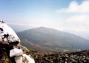
while to the north east is Gleann Mòr which separates the mountain from Schiehallion
Schiehallion
Schiehallion is a prominent mountain in Perth and Kinross, Scotland. Schiehallion has a rich botanical life, interesting archaeology, and a unique place in scientific history for an 18th-century experiment in 'weighing the world'...
which is four km distant. All drainage from the mountain feeds the River Tay
River Tay
The River Tay is the longest river in Scotland and the seventh-longest in the United Kingdom. The Tay originates in western Scotland on the slopes of Ben Lui , then flows easterly across the Highlands, through Loch Dochhart, Loch Lubhair and Loch Tay, then continues east through Strathtay , in...
either going north and then via the River Tummel or south and via the River Lyon.
Ascents
Càrn Mairg is usually climbed from Invervar (grid reference ) in Glen Lyon as part of the circuit of the four Carn Mairg group Munros. For many years parking was a problem on the narrow road but the car park built by the Chesthill estate has eased this difficulty. The clockwise circuit follows the Invervar Burn for just over a km until the forest is left behind, then the first Munro of Càrn Gorm can be climbed by going west, the route then goes to Meall Garbh before reaching Càrn Mairg. Navigation throughout the walk is aided by a dilapidated line of old rusting fence posts which follow the ridge. A direct ascent is possible from Fortingall (grid reference ) up Gleann Muilinn but this is a round trip of around 20 km. The summit is marked by a large cairnCairn
Cairn is a term used mainly in the English-speaking world for a man-made pile of stones. It comes from the or . Cairns are found all over the world in uplands, on moorland, on mountaintops, near waterways and on sea cliffs, and also in barren desert and tundra areas...
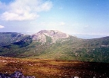
of quartzite boulders and gives a fine view of Schiehallion to the NE (see picture).