

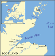
Moray Firth
Encyclopedia
Inlet
An inlet is a narrow body of water between islands or leading inland from a larger body of water, often leading to an enclosed body of water, such as a sound, bay, lagoon or marsh. In sea coasts an inlet usually refers to the actual connection between a bay and the ocean and is often called an...
(or firth
Firth
Firth is the word in the Lowland Scots language and in English used to denote various coastal waters in Scotland and England. In mainland Scotland it is used to describe a large sea bay, or even a strait. In the Northern Isles it more usually refers to a smaller inlet...
) of the North Sea
North Sea
In the southwest, beyond the Straits of Dover, the North Sea becomes the English Channel connecting to the Atlantic Ocean. In the east, it connects to the Baltic Sea via the Skagerrak and Kattegat, narrow straits that separate Denmark from Norway and Sweden respectively...
, north and east of Inverness
Inverness
Inverness is a city in the Scottish Highlands. It is the administrative centre for the Highland council area, and is regarded as the capital of the Highlands of Scotland...
, which is in the Highland
Highland (council area)
Highland is a council area in the Scottish Highlands and is the largest local government area in both Scotland and the United Kingdom as a whole. It shares borders with the council areas of Moray, Aberdeenshire, Perth and Kinross, and Argyll and Bute. Their councils, and those of Angus and...
council area of north of Scotland
Scotland
Scotland is a country that is part of the United Kingdom. Occupying the northern third of the island of Great Britain, it shares a border with England to the south and is bounded by the North Sea to the east, the Atlantic Ocean to the north and west, and the North Channel and Irish Sea to the...
. It is the largest firth in Scotland, stretching from Duncansby Head
Duncansby Head
Duncansby Head is the most north-easterly part of the Scottish mainland, including even the famous John o' Groats, Caithness, Highland...
(near John o' Groats
John o' Groats
John o' Groats is a village in the Highland council area of Scotland. Part of the county of Caithness, John o' Groats is popular with tourists because it is usually regarded as the most northerly settlement of mainland Great Britain, although this is not a claim made by the inhabitants...
) in the north, in the Highland council area, and Fraserburgh
Fraserburgh
Fraserburgh is a town in Aberdeenshire, Scotland with a population recorded in the 2001 Census at 12,454 and estimated at 12,630 in 2006. It lies at the extreme northeast corner of Aberdeenshire, around north of Aberdeen, and north of Peterhead...
in the east, in the Aberdeenshire
Aberdeenshire
Aberdeenshire is one of the 32 unitary council areas in Scotland and a lieutenancy area.The present day Aberdeenshire council area does not include the City of Aberdeen, now a separate council area, from which its name derives. Together, the modern council area and the city formed historic...
council area, to Inverness and the Beauly Firth
Beauly Firth
The Beauly Firth is a firth in northern Scotland. It is effectively a continuation of the Moray Firth westward, and is bounded at one end by Beauly and at the other by Inverness . The Kessock Ferry has crossed at the eastern end since the 15th Century...
in the west. Therefore three council areas have Moray Firth coastline: Highland to the west and north of the Moray Firth and Highland, Moray
Moray
Moray is one of the 32 council areas of Scotland. It lies in the north-east of the country, with coastline on the Moray Firth, and borders the council areas of Aberdeenshire and Highland.- History :...
and Aberdeenshire to the south. The firth has more than 800 kilometres (about 500 miles) of coastline, much of which is cliff.
Geography
A number of rivers flow into the Moray Firth, including the River NessRiver Ness
The River Ness is a river flowing from Loch Ness in Scotland, north to Inverness and the Moray Firth. On a hill above the river in Inverness stands Inverness Castle. The river is overlooked by the Eden Court Theatre, one of the largest theatres in Scotland. St. Andrews Cathedral also lies along...
, the River Findhorn
River Findhorn
The River Findhorn is one of the longest rivers in Scotland. Located in the north east, it flows into the Moray Firth on the north coast. It has one of the largest non-firth estuaries in Scotland....
and the River Spey
River Spey
The River Spey is a river in the northeast of Scotland, the second longest and the fastest-flowing river in Scotland...
. Various smaller firths and bay
Headlands and bays
Headlands and bays are two related features of the coastal environment.- Geology and geography :Headlands and bays are often found on the same coastline. A bay is surrounded by land on three sides, whereas a headland is surrounded by water on three sides. Headlands are characterized by high,...
s are inlets of the firth, including the Cromarty Firth
Cromarty Firth
The Cromarty Firth of Cromarty') is an arm of the North Sea in Scotland. It is the middle of the three sea lochs at the head of the Moray Firth: to the north lies the Dornoch Firth, and to the south the Beauly Firth....
and the Dornoch Firth
Dornoch Firth
The Dornoch Firth is a firth on the east coast of Highland, in northern Scotland. It forms part of the boundary between Ross and Cromarty, to the south, and Sutherland, to the north....
. The Pentland Firth
Pentland Firth
The Pentland Firth , which is actually more of a strait than a firth, separates the Orkney Islands from Caithness in the north of Scotland.-Etymology:...
has its eastern mouth at the Moray Firth's northern boundary.
The Moray Firth is effectively two firths, the Inner Moray Firth 57°33′N 04°09′W, which was traditionally known as the Firth of Inverness, and the Outer Moray Firth which is more open North Sea water. The name "Firth of Inverness" is rarely found on modern maps, but extended from the Beauly Firth
Beauly Firth
The Beauly Firth is a firth in northern Scotland. It is effectively a continuation of the Moray Firth westward, and is bounded at one end by Beauly and at the other by Inverness . The Kessock Ferry has crossed at the eastern end since the 15th Century...
in the west, to Chanonry Point
Chanonry Point
Chanonry Point lies at the end of Chanonry Ness, a spit of land extending into the Moray Firth between Fortrose and Rosemarkie on the Black Isle, Scotland....
in the east.
The Moray Firth is visible for considerable distances, including a long range view from as far to the east as Longman Hill
Longman Hill
Longman Hill is a prehistoric monument in northern Aberdeenshire, Scotland near Banff Bay. Due to the low lying coastal plain characteristics, the elevation of Longman Hill affords a long distance view as far as the Moray Firth....
.
The Great Channel in the Inner Moray Firth, was dredged by engineers in 1917 for the safe passage of ships that wanted to avoid the long and dangerous passage around the north of Scotland, by transiting the Caledonian Canal
Caledonian Canal
The Caledonian Canal is a canal in Scotland that connects the Scottish east coast at Inverness with the west coast at Corpach near Fort William. It was constructed in the early nineteenth century by engineer Thomas Telford, and is a sister canal of the Göta Canal in Sweden, also constructed by...
. The Channel went from the entrance of Munlochy Bay to the Meikle Mee Starboard Hand Mark, but was not maintained and filled in very quickly.
Conservation and economy
The Moray Firth is one of the most important places on the U.K.United Kingdom
The United Kingdom of Great Britain and Northern IrelandIn the United Kingdom and Dependencies, other languages have been officially recognised as legitimate autochthonous languages under the European Charter for Regional or Minority Languages...
coast for observing dolphin
Dolphin
Dolphins are marine mammals that are closely related to whales and porpoises. There are almost forty species of dolphin in 17 genera. They vary in size from and , up to and . They are found worldwide, mostly in the shallower seas of the continental shelves, and are carnivores, mostly eating...
s and whale
Whale
Whale is the common name for various marine mammals of the order Cetacea. The term whale sometimes refers to all cetaceans, but more often it excludes dolphins and porpoises, which belong to suborder Odontoceti . This suborder also includes the sperm whale, killer whale, pilot whale, and beluga...
s. The most common species are the Bottlenose Dolphin
Bottlenose Dolphin
Bottlenose dolphins, the genus Tursiops, are the most common and well-known members of the family Delphinidae, the family of oceanic dolphins. Recent molecular studies show the genus contains two species, the common bottlenose dolphin and the Indo-Pacific bottlenose dolphin , instead of one...
and the Harbour Porpoise
Harbour Porpoise
The harbour porpoise is one of six species of porpoise. It is one of the smallest marine mammals. As its name implies, it stays close to coastal areas or river estuaries, and as such, is the most familiar porpoise to whale watchers. This porpoise often ventures up rivers, and has been seen...
. With occasional sightings of Common dolphin
Common dolphin
The common dolphin is the name given to two species of dolphin making up the genus Delphinus.Prior to the mid-1990s, most taxonomists only recognised one species in this genus, the common dolphin Delphinus delphis...
and Minke Whale
Minke Whale
Minke whale , or lesser rorqual, is a name given to two species of marine mammal belonging to a clade within the suborder of baleen whales. The minke whale was given its official designation by Lacepède in 1804, who described a dwarf form of Balænoptera acuto-rostrata...
. The popular wildlife
Wildlife
Wildlife includes all non-domesticated plants, animals and other organisms. Domesticating wild plant and animal species for human benefit has occurred many times all over the planet, and has a major impact on the environment, both positive and negative....
viewing area located at Chanonry Point
Chanonry Point
Chanonry Point lies at the end of Chanonry Ness, a spit of land extending into the Moray Firth between Fortrose and Rosemarkie on the Black Isle, Scotland....
host some spectacular displays of dolphins within the inner Moray Firth. There are also visitor centres at Spey Bay
Spey Bay
Spey Bay is a small settlement in Moray, Scotland. It is situated at the eastern side of the mouth of the River Spey on the coast of the Moray Firth between the village of Kingston on the western side of the Spey, and the fishing port of Buckie to the east....
and North Kessock
North Kessock
North Kessock is a village on the Black Isle north of Inverness.-Description:...
run by the Whale and Dolphin Conservation Society
Whale and Dolphin Conservation Society
the Whale and Dolphin Conservation Society is a wildlife charity that is dedicated solely to the worldwide conservation and welfare of all whales, dolphins and porpoises...
where dolphins and other wildlife can often be seen. The old jetty at the Fort George Point is the location of the Dolphin Research Centre, with leading marine biologist Prof. Greame Taylor working part time studying hunting and breeding habits and part time working with the Community Council giving tours and teaching the ways of the dolphin.
It is also an important oil field
Oil field
An oil field is a region with an abundance of oil wells extracting petroleum from below ground. Because the oil reservoirs typically extend over a large area, possibly several hundred kilometres across, full exploitation entails multiple wells scattered across the area...
and fishing grounds. The Beatrice oil field in the Outer Moray Firth is the closest of the North Sea oil fields; it is also the planned home for a 200-turbine
Wind turbine
A wind turbine is a device that converts kinetic energy from the wind into mechanical energy. If the mechanical energy is used to produce electricity, the device may be called a wind generator or wind charger. If the mechanical energy is used to drive machinery, such as for grinding grain or...
deep-water wind farm
Wind farm
A wind farm is a group of wind turbines in the same location used to produce electric power. A large wind farm may consist of several hundred individual wind turbines, and cover an extended area of hundreds of square miles, but the land between the turbines may be used for agricultural or other...
. Much of the fishing industry focuses on scallop
Scallop
A scallop is a marine bivalve mollusk of the family Pectinidae. Scallops are a cosmopolitan family, found in all of the world's oceans. Many scallops are highly prized as a food source...
s and Norway lobster
Norway lobster
Nephrops norvegicus, known variously as the Norway lobster, Dublin Bay prawn, or scampi, is a slim, orange-pink lobster which grows up to long, and is "the most important commercial crustacean in Europe"...
s.
The Inner Moray Firth is designated as a Special Protection Area
Special Protection Area
A Special Protection Area or SPA is a designation under the European Union Directive on the Conservation of Wild Birds.Under the Directive, Member States of the European Union have a duty to safeguard the habitats of migratory birds and certain particularly threatened birds.Together with Special...
for wildlife conservation purposes.
The Moray Firth contains a Special Area of Conservation
Special Area of Conservation
A Special Area of Conservation is defined in the European Union's Habitats Directive , also known as the Directive on the Conservation of Natural Habitats and of Wild Fauna and Flora...
(SAC) designated under the EU Habitats Directive, which is one of the largest Marine Protection Areas in Europe
Europe
Europe is, by convention, one of the world's seven continents. Comprising the westernmost peninsula of Eurasia, Europe is generally 'divided' from Asia to its east by the watershed divides of the Ural and Caucasus Mountains, the Ural River, the Caspian and Black Seas, and the waterways connecting...
. The SAC protects the inner waters of the Moray Firth, from a line between Lossiemouth
Lossiemouth
Lossiemouth is a town in Moray, Scotland. Originally the port belonging to Elgin, it became an important fishing town. Although there has been over a 1,000 years of settlement in the area, the present day town was formed over the past 250 years and consists of four separate communities that...
(on the south coast) and Helmsdale
Helmsdale
Helmsdale is a village on the east coast of Sutherland, in the Highland council area of Scotland. The modern village was planned in 1814 to resettle communities that had been removed from the surrounding straths as part of the Highland Clearances....
(on the north coast) westwards.
Map references
| Latitude and longitude Geographic coordinate system A geographic coordinate system is a coordinate system that enables every location on the Earth to be specified by a set of numbers. The coordinates are often chosen such that one of the numbers represent vertical position, and two or three of the numbers represent horizontal position... |
Ordnance Survey Ordnance Survey Ordnance Survey , an executive agency and non-ministerial government department of the Government of the United Kingdom, is the national mapping agency for Great Britain, producing maps of Great Britain , and one of the world's largest producers of maps.The name reflects its creation together with... grid reference British national grid reference system The Ordnance Survey National Grid reference system is a system of geographic grid references used in Great Britain, different from using latitude and longitude.... |
|
|---|---|---|
| Duncansby Head Duncansby Head Duncansby Head is the most north-easterly part of the Scottish mainland, including even the famous John o' Groats, Caithness, Highland... |
58°38′40"N 03°01′28"W | |
| Chanonry Point Chanonry Point Chanonry Point lies at the end of Chanonry Ness, a spit of land extending into the Moray Firth between Fortrose and Rosemarkie on the Black Isle, Scotland.... |
57°34′29"N 04°05′22"W | |
| Inverness Inverness Inverness is a city in the Scottish Highlands. It is the administrative centre for the Highland council area, and is regarded as the capital of the Highlands of Scotland... (Kessock Bridge Kessock Bridge The Kessock Bridge carries the A9 trunk road across the Beauly Firth at Inverness.-Description:The Kessock Bridge is a cable-stayed bridge across the Beauly Firth, an inlet of the Moray Firth, between the village of North Kessock and the city of Inverness in the Scottish Highlands.The bridge has a... ) |
57°29′58"N 04°13′43"W | |
| Fraserburgh Fraserburgh Fraserburgh is a town in Aberdeenshire, Scotland with a population recorded in the 2001 Census at 12,454 and estimated at 12,630 in 2006. It lies at the extreme northeast corner of Aberdeenshire, around north of Aberdeen, and north of Peterhead... (Kinnaird Head) |
57°41′56"N 02°00′03"W |