
.gif)
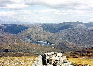
Càrn nan Gobhar (Mullardoch)
Encyclopedia
Scotland
Scotland is a country that is part of the United Kingdom. Occupying the northern third of the island of Great Britain, it shares a border with England to the south and is bounded by the North Sea to the east, the Atlantic Ocean to the north and west, and the North Channel and Irish Sea to the...
mountain situated on the northern side of Loch Mullardoch in the upper part of Glen Cannich. It stands some 50 kilometres west-southwest of the city of Inverness
Inverness
Inverness is a city in the Scottish Highlands. It is the administrative centre for the Highland council area, and is regarded as the capital of the Highlands of Scotland...
in a remote group of four Munro
Munro
A Munro is a mountain in Scotland with a height over . They are named after Sir Hugh Munro, 4th Baronet , who produced the first list of such hills, known as Munros Tables, in 1891. A Munro top is a summit over 3,000 ft which is not regarded as a separate mountain...
s informally known as “The Mullardochs” which form the high ground between Loch Mullardoch and Loch Monar.
Overview
Càrn nan Gobhar reaches a height of 992 metres (3254 feet) and qualifies as a MunroMunro
A Munro is a mountain in Scotland with a height over . They are named after Sir Hugh Munro, 4th Baronet , who produced the first list of such hills, known as Munros Tables, in 1891. A Munro top is a summit over 3,000 ft which is not regarded as a separate mountain...
and a Marilyn
Marilyn (hill)
A Marilyn is a mountain or hill in the United Kingdom, Republic of Ireland or Isle of Man with a relative height of at least 150 metres , regardless of absolute height or other merit...
. Somewhat confusingly there is another Càrn nan Gobhar
Càrn nan Gobhar (Strathfarrar)
Càrn nan Gobhar is a mountain situated on the northern side of Glen Strathfarrar in Scotland. It stands some 40 kilometres west of the city of Inverness.It is usually climbed along with the neighbouring Munros of Sgurr a' Choire Ghlais and Sgurr na Ruaidhe....
, also a Munro with exactly the same height situated 14 kilometres to the north east on the northern side of Glen Strathfarrar, the two should not be confused. Càrn nan Gobhar is the smallest of the four Mullardochs and is rather overshadowed by them in height. Topographically it is quite featureless being mainly composed of rolling grassy slopes interspersed with patches of rock and scree although there are steeper slopes on the west and east flanks. The hills name translates from the Gaelic
Scottish Gaelic language
Scottish Gaelic is a Celtic language native to Scotland. A member of the Goidelic branch of the Celtic languages, Scottish Gaelic, like Modern Irish and Manx, developed out of Middle Irish, and thus descends ultimately from Primitive Irish....
as “Cairn (i.e. hill) of the Goats”
Geography
Càrn nan Gobhar is composed of three main ridges giving the mountain a rough triangular shape. The 3.5 km long SSE ridge goes over the subsidiary top of Mullach na Moille (761 metres) before swinging more easterly and dropping down to the eastern end of Loch Mullardoch. The north western ridge links to the adjoining Munro of Sgurr na LapaichSgurr na Lapaich
Sgurr na Lapaich is a mountain in the Northwest Highlands of Scotland, situated north of Loch Mullardoch in the high ground that separates Glen Cannich and Glen Strathfarrar. The mountain reaches a height of 1,150 metres , and is the fourth highest mountain north of the Great Glen...
across the Bealach
Mountain pass
A mountain pass is a route through a mountain range or over a ridge. If following the lowest possible route, a pass is locally the highest point on that route...
na Cloiche Duibhe which has a height of 796 metres. A third ridge goes north east for two km and connects to the Munro “Top” of Creag Dubh (946 metres). Creag Dubh was initially named as a Munro in Sir Hugh Munro
Hugh Munro
Sir Hugh Thomas Munro, 4th Baronet of Linderits was a Scottish mountaineer who is best known for his list of mountains in Scotland over 3,000 feet , known as the Munros....
’s origin list of 1891 but was downgraded to a top in 1921. It has just under 100 metres of prominence from the main summit and its north eastern slopes are initially rocky as they drop down to the Glen Strathfarrar Forest.
Càrn nan Gobhar’s best feature is its south facing corrie
Cirque
Cirque may refer to:* Cirque, a geological formation* Makhtesh, an erosional landform found in the Negev desert of Israel and Sinai of Egypt*Cirque , an album by Biosphere* Cirque Corporation, a company that makes touchpads...
of Coire an t-Sith (Corrie of the Fairies) it is drained by the Allt Mullardoch which descend to Loch Mullardoch in a series of small waterfalls. The corrie carries a well constructed stalkers path which can be well utilised when doing a high level circuit of the corrie which takes in the Munro summit and the “top”. All drainage from the mountain goes to the east coast of Scotland at the Beauly Firth
Beauly Firth
The Beauly Firth is a firth in northern Scotland. It is effectively a continuation of the Moray Firth westward, and is bounded at one end by Beauly and at the other by Inverness . The Kessock Ferry has crossed at the eastern end since the 15th Century...
via the glens of Strathfarrar or Cannich.
Ascent and summit
The best starting point for the ascent of Càrn nan Gobhar is the parking spot at the end of the public road in Glen Cannich by the Loch Mullardoch dam at grid reference . The route follows the northern shore of the loch for 1.5 km before ascending steeply up the SSE ridge passing over Mullach na Moille on the way to the summit. The mountain is often climbed in conjunction with Sgurr na Lapaich and strong walkers will also take in the other two Mullardoch Munros of An RiabhachanAn Riabhachan
An Riabhachan is a Scottish mountain in the Skye and Lochalsh district of the Highland council area. It is situated 35 kilometres east of Kyle of Lochalsh standing in an isolated position at the western end of Loch Mullardoch, ten kilometres from any public road.- Overview :An Riabhachan reaches a...
and An Sochach.
The summit of the mountain is basically a flat broad north-south ridge but there are two definite high points, 200 metres apart and both with cairns. The southern cairn is bigger and stands at an approximate height of 985 metres, the true northern summit has a smaller cairn and gives good views north to the Monar Forest Munros of Maoile Lunndaidh
Maoile Lunndaidh
Maoile Lunndaidh is a Scottish mountain situated 13 km south of Achnasheen in the Ross and Cromarty district of the Highland council area...
and Lurg Mhor. It is also a good viewpoint for the corries and cliffs of the close at hand Sgurr na Lapaich.