Càrn Aosda
Encyclopedia

Scotland
Scotland is a country that is part of the United Kingdom. Occupying the northern third of the island of Great Britain, it shares a border with England to the south and is bounded by the North Sea to the east, the Atlantic Ocean to the north and west, and the North Channel and Irish Sea to the...
mountain situated 12.5 km south of the town of Braemar
Braemar
Braemar is a village in Aberdeenshire, Scotland, around west of Aberdeen in the Highlands. It is the closest significantly-sized settlement to the upper course of the River Dee sitting at an altitude of ....
, in the county of Aberdeenshire
Aberdeenshire
Aberdeenshire is one of the 32 unitary council areas in Scotland and a lieutenancy area.The present day Aberdeenshire council area does not include the City of Aberdeen, now a separate council area, from which its name derives. Together, the modern council area and the city formed historic...
. It stands near the summit of the Cairnwell Pass
Cairnwell Pass
The Cairnwell Pass is a mountain pass on the A93 road between Glen Shee, Perthshire, and Braemar, Aberdeenshire, in the Scottish Highlands. The border between the two counties crosses the summit of the pass...
on the A93 road
A93 road
The A93 is a major road in Scotland and the highest public road in the United Kingdom. It runs north from Perth through Blairgowrie and Rattray, then through the Grampian Mountains by way of Glenshee, the Cairnwell Pass and Glen Clunie to Braemar in Aberdeenshire...
, in the midst of the Glenshee Ski Centre
Glenshee Ski Centre
Glenshee Ski Centre is the largest ski resort in Scotland and is sometimes referred to as the Scottish three valleys. It is located in Aberdeenshire and to the north of Spittal of Glenshee, on the A93 road between Blairgowrie and Braemar in the southern Highlands of Scotland...
.
Overview
Càrn Aosda reaches a height of 917 metres (3008 feet), at one point in time it had the honour of being the lowest of the MunroMunro
A Munro is a mountain in Scotland with a height over . They are named after Sir Hugh Munro, 4th Baronet , who produced the first list of such hills, known as Munros Tables, in 1891. A Munro top is a summit over 3,000 ft which is not regarded as a separate mountain...
s but more accurate mapping techniques have changed this and it is now the 279th ranked mountain in that classification. Càrn Aosda, along with the adjoining Munro of The Cairnwell
The Cairnwell
The Cairnwell is a mountain in the Eastern Highlands of Scotland, south of Braemar. It is often considered to be one of the most spoiled of the Munros, due to the Glenshee Ski Centre which covers the eastern slope of the mountain....
, is regarded as the easiest of the Munros to ascend, this is because of the high starting altitude of over 640 metres at the ski centre and the easy walking conditions on rough vehicle tracks which lead directly to the summit. A fit hill walker can complete the 275 metre ascent from the centre car park in half an hour.
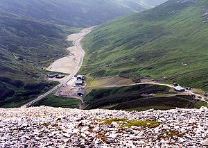
Apart from being the easiest Munro, Càrn Aosda also has the reputation as being one of the most despoiled, with the mountain having snow fence
Snow fence
A snow fence is a structure, similar to a sand fence, that forces drifting snow to accumulate in a desired place. They are primarily employed to minimize the amount of snowdrift on roadways and railways. Farmers and ranchers may use temporary snow fences to create large drifts in basins for a...
s, ski tow supports, huts and vehicle tracks right up to the summit as part of the Glenshee ski centre. The mountain has four piste
Piste
A piste is a marked ski run or path down a mountain for snow skiing, snowboarding, or other mountain sports. The term is European, from the French for trail or track, synonymous with trail, slope, or groomed run in North America....
s on its slopes, there is a run for beginners plus two for intermediate level on the easier slopes which go south from the summit into Butchart’s Corrie. There is a piste ranked as difficult on the steeper slopes of the eastern shoulder. There are also three towbar lifts on the southern slopes to service the ski runs one of which goes past the 900 metre mark to just a few metres from the summit.
The mountain's name translates from the Scottish Gaelic language
Scottish Gaelic language
Scottish Gaelic is a Celtic language native to Scotland. A member of the Goidelic branch of the Celtic languages, Scottish Gaelic, like Modern Irish and Manx, developed out of Middle Irish, and thus descends ultimately from Primitive Irish....
as "Aged Hill/Cairn" with aosda meaning aged or ancient and most guide books carry this meaning. However an alternative meaning has been put forward as “Hill of the Inn” derived from the word òsda, in history there was an inn at the foot of the mountain at the Sean Spittal bridge where the Cairnwell Burn flows under the main Cairnwell pass road and this is could possibly have given the mountain its name.
Geography
Càrn Aosda throws out a four km long northern ridge which descends to the hamlet of Baddoch on the A93 road. Another shorter ridge goes NE and along with the north ridge encloses the Dubh-choireCirque
Cirque may refer to:* Cirque, a geological formation* Makhtesh, an erosional landform found in the Negev desert of Israel and Sinai of Egypt*Cirque , an album by Biosphere* Cirque Corporation, a company that makes touchpads...
. Càrn Aosda's southern slopes descend into Butchart’s corrie which is drained by the headwaters of the Cairnwell Burn, the corrie is surprisingly unnamed on OS
Ordnance Survey
Ordnance Survey , an executive agency and non-ministerial government department of the Government of the United Kingdom, is the national mapping agency for Great Britain, producing maps of Great Britain , and one of the world's largest producers of maps.The name reflects its creation together with...
maps being well known by the skiing fraternity with two of the ski tows being named Butcharts access poma and Butcharts T Bar respectively.
The easy inclined broad slopes which go south west from the summit descends to the 795 metre col at the head of Butchart’s corrie from here the neighbouring Munros of The Cairnwell and Càrn a' Gheòidh
Càrn a' Gheòidh
Càrn a' Gheòidh is a Scottish mountain situated 15 km south of the town of Braemar. Its summit stands on the border between the council areas of Perth and Kinross and Aberdeenshire.- Overview :...
can be easily climbed. 200 metres west of the col is Loch Vrotachan, owned by the Ballater
Ballater
Ballater is a burgh in Aberdeenshire, Scotland on the River Dee, immediately east of the Cairngorm Mountains. Situated at a height of 123m in elevation, Ballater is a centre for hikers and known for its spring water, once said to cure scrofula.-History:The medieval pattern of development along...
Angling
Angling
Angling is a method of fishing by means of an "angle" . The hook is usually attached to a fishing line and the line is often attached to a fishing rod. Fishing rods are usually fitted with a fishing reel that functions as a mechanism for storing, retrieving and paying out the line. The hook itself...
club this offers good trout
Trout
Trout is the name for a number of species of freshwater and saltwater fish belonging to the Salmoninae subfamily of the family Salmonidae. Salmon belong to the same family as trout. Most salmon species spend almost all their lives in salt water...
fishing at a height of 750 metres. The summit itself is made up of small light coloured quartzite
Quartzite
Quartzite is a hard metamorphic rock which was originally sandstone. Sandstone is converted into quartzite through heating and pressure usually related to tectonic compression within orogenic belts. Pure quartzite is usually white to gray, though quartzites often occur in various shades of pink...
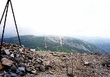
rocks, giving the mountain a distinctive appearance. There are twin summit bumps with the western top having a height of 903 metres while the true top lies 400 metres to the east and is marked by a small pile of quartzite boulders. Càrn Aosda very much belongs to the eastern half of Scotland and all drainage goes via Glen Clunie and the River Dee
River Dee, Aberdeenshire
The River Dee is a river in Aberdeenshire, Scotland. It rises in the Cairngorms and flows through Strathdee to reach the North Sea at Aberdeen...
to reach the east coast at Aberdeen
Aberdeen
Aberdeen is Scotland's third most populous city, one of Scotland's 32 local government council areas and the United Kingdom's 25th most populous city, with an official population estimate of ....
.
Ascents and view
Càrn Aosda is invariably climbed with one or both of the nearby Munros of The Cairnwell and Càrn a' Gheòidh. This walk offers the Munro bagger the opportunity of climbing three Munros with minimum effort. The walk starts at the ski centre car park and only involves 580 metres of climbing to ascend the three mountains from the col at the head of Butchart’s corrie; this can be done in three hours. A more aesthetically pleasing route for the mountain purist which avoids the ski area altogether begins on the A93 at the start of the track to Baddoch (grid reference ) and climbs the long north ridge to the summit. The view from the summit takes in the ski area to the south but in other directions there are excellent vistas of the mountains of the MounthMounth
The Mounth is the range of hills on the southern edge of Strathdee in northeast Scotland. It was usually referred to with the article, i.e. "the Mounth". The name is a corruption of the Scottish Gaelic monadh which in turn is akin to the Welsh mynydd, and may be of Pictish origin...
and the Cairngorms
Cairngorms
The Cairngorms are a mountain range in the eastern Highlands of Scotland closely associated with the mountain of the same name - Cairn Gorm.-Name:...
.

