
.gif)
Stob Bàn (Grey Corries)
Encyclopedia
Lochaber
District of Lochaber 1975 to 1996Highland council area shown as one of the council areas of ScotlandLochaber is one of the 16 ward management areas of the Highland Council of Scotland and one of eight former local government districts of the two-tier Highland region...
region of Highland
Highland (council area)
Highland is a council area in the Scottish Highlands and is the largest local government area in both Scotland and the United Kingdom as a whole. It shares borders with the council areas of Moray, Aberdeenshire, Perth and Kinross, and Argyll and Bute. Their councils, and those of Angus and...
, Scotland
Scotland
Scotland is a country that is part of the United Kingdom. Occupying the northern third of the island of Great Britain, it shares a border with England to the south and is bounded by the North Sea to the east, the Atlantic Ocean to the north and west, and the North Channel and Irish Sea to the...
, 16 kilometres east of Fort William. It reaches a height of 977 metres (3205 feet) and lies in a group of hills known as the Grey Corries which includes three other Munro
Munro
A Munro is a mountain in Scotland with a height over . They are named after Sir Hugh Munro, 4th Baronet , who produced the first list of such hills, known as Munros Tables, in 1891. A Munro top is a summit over 3,000 ft which is not regarded as a separate mountain...
s and nine Munro "Tops" along an eight kilometre ridge. The mountain’s name translate as “White Peak”, while other sources give the translation as Light Coloured Peak with the hill being covered in light coloured schist
Schist
The schists constitute a group of medium-grade metamorphic rocks, chiefly notable for the preponderance of lamellar minerals such as micas, chlorite, talc, hornblende, graphite, and others. Quartz often occurs in drawn-out grains to such an extent that a particular form called quartz schist is...
scree
Scree
Scree, also called talus, is a term given to an accumulation of broken rock fragments at the base of crags, mountain cliffs, or valley shoulders. Landforms associated with these materials are sometimes called scree slopes or talus piles...
, in contrast to the rest of the Grey Corries which are made up of grey quartzite
Quartzite
Quartzite is a hard metamorphic rock which was originally sandstone. Sandstone is converted into quartzite through heating and pressure usually related to tectonic compression within orogenic belts. Pure quartzite is usually white to gray, though quartzites often occur in various shades of pink...
scree. The mountain is a prominent conical shape, isolated from the rest of the group and distant from any main roads. It should not be confused with another Munro named Stob Bàn
Stob Bàn (Mamores)
Stob Bàn is a Scottish mountain situated at the western end of the Mamores ridge, five and a half kilometres north-west of Kinlochleven. With a height of 999 metres it qualifies as a Munro...
situated in the Mamores
Mamores
The Mamores are a group of mountains in the Lochaber area of the Grampian Mountains in the Scottish Highlands. They form an east-west ridge approximately fifteen kilometres in length lying between Glen Nevis to the north and Loch Leven to the south....
.
Stob Bàn lies south of the main Grey Corries ridge, connected to it and the highest mountain of the group, Stob Choire Claurigh
Stob Choire Claurigh
Stob Choire Claurigh is a Scottish mountain situated east of Fort William in the Lochaber district of the Highland council area...
, by an unnamed col
Mountain pass
A mountain pass is a route through a mountain range or over a ridge. If following the lowest possible route, a pass is locally the highest point on that route...
with a height of 800 metres, this col has a small lochan also unnamed lying within it. Stob Bàn’s conical shape is formed by three distinct ridges. The north eastern ridge drops to the valley of the Allt na Lairige which flows southerly into Loch Treig
Loch Treig
Loch Treig is a 9 km freshwater loch situated in a steep-sided glen 20 km east of Fort William, in Lochaber, Highland, Scotland...
. The south western ridge is gentle in gradient dropping down to a col at 750 metres before rising to the subsidiary summit of Meall a’ Bhuirich (841 metres) which stands two kilometres from the main summit. The northern ridge is steep and connects to the Munro of Stob Choire Claurigh with rough scree underfoot with some care needed by walkers traversing between the two mountains.
Stob Bàn’s north eastern face is precipitous and craggy and drops steeply to the valley of the Allt na Lairige. All drainage from the mountain finds its way to Loch Treig to reach the sea via the River Spean and Loch Linnhe
Loch Linnhe
Loch Linnhe is a sea loch on the west coast of Scotland....
at the west coast. One unusual characteristic of Stob Bàn is the so called “Giants Staircase”, this is a 200 metre stretch of quartzite slabs encountered when descending from the 800 metre col between Stob Bàn and Stob Choire Claurigh to the Lairig Leacach, the staircase is awkward to negotiate especially in wet conditions.
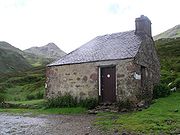
The direct ascent of Stob Bàn is usually undertaken from Corrie Choille farm in Glen Spean" at grid reference . Going south, following the old Drovers' road between Glen Spean and Loch Treig, going over the pass of the Lairig Leacach and dropping down to the Lairig Leacach bothy
Bothy
A bothy is a basic shelter, usually left unlocked and available for anyone to use free of charge. It was also a term for basic accommodation, usually for gardeners or other workers on an estate. Bothies are to be found in remote, mountainous areas of Scotland, northern England, Ireland, and Wales....
. From here strike up the hillside to reach the east ridge which leads to the summit. Stob Bàn is often climbed in conjunction with some or all of the Grey Corries Munros, this walk also starts from Corrie Choille farm. The view from the summit is very good with the Mamores and the hills around Loch Treig looking fine.