
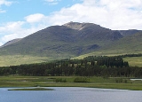
Stob Ghabhar
Encyclopedia
Stob Ghabhar is a Scottish
mountain situated nine kilometres north west of Bridge of Orchy
. It is part of the Black Mount group of mountains and stands on the border of the Argyll and Bute
and Highland
council areas.
as it skirts the western edge of Rannoch Moor
. The mountains eastern corries formed by the headwaters of the River Ba look impressive from this direction as does the neighbouring mountain of Stob a' Choire Odhair
with which Stob Ghabhar is usually climbed. It reaches a height of 1090 metres (3576 feet) and qualifies as a Munro
and a Marilyn
. The mountains name translates from the Gaelic
language as “Goats Peak”. Goats were often encouraged by shepherds on mountains with precipitous cliffs such as Stob Ghabhar to keep sheep away from the steep drops.
and Meall a' Bhuiridh
), it is a large and impressive mountain with long ridges radiating from it prominent pointed summit and deep scalloped corrie
s on its flanks. The three main ridges go east, west and north west from the highest point and have on them four lesser peaks which are listed as “tops” in the Munro Tables. The east ridge goes over the subsidiary “top” of Aonach Eagach (991 metres) before continuing to the adjoining Munro of Stob a' Choire Odhair. The western ridge is initially narrow as it traverses the crest of two opposing corries before reaching the “top” of Sròn a' Ghearrain (990 metres) after a kilometre. Stob a' Bhruaich Leith (941 metres) lies 1.5 kilometres further along the ridge which then drops down gradually towards Glen Etive
. The fourth Munro Top Sròn nan Giubhas (976 metres) lies 700 metres north of the main summit along a ridge which then swings north west and descends for five kilometres to Glen Etive.
Stob Ghabhar’s other notable geographical features are its corries and cliffs. Coire Dhearbhadh which stands on the mountain’s eastern flank is ringed by sheer cliffs and contains the small loch
an, Coirein Lochain. The steep headwall of this corrie contains the upper couloir
, a deep gully which provides a tough scrambling route to the summit in summer and a classic ice route in winter which was first climbed in 1897. The summit stands on the edge of the cliffs overlooking the corrie.
Two other large corries stand to the west of the summit, Coire a’ Chaolain on the northern side of the west ridge and Coire Ghabhar on the southern side, these two corries almost touch and make the ridge quite narrow. Drainage from the mountain finds its way to both the east and west coasts of Scotland, the northern slopes drain via the River Etive and Loch Etive
to the west coast near Oban
. Water from the southern slopes goes to the same place but progresses by Glen Orchy
and Loch Awe
while the eastern slopes drain via Loch Rannoch
and the River Tay
to the east coast at the Firth of Tay
. The whole of the Black Mount range is noted for the complexity of its geology, there is a junction of gneiss
and Cruachan granite
near the summit of Stob Ghabhar.
(1724–1812) one of Scotlands greatest poets in the Gaelic tradition was born in the southern foothills of Stob Ghabhar at the croft of Druim Liaghart near Victoria Bridge. MacIntyre, whose birthplace is marked by a plinth, worked as a forester and gamekeeper in the area until 1767 when he moved to Edinburgh
. Much of his poetry was concerned with the flora, fauna and mountains of the area.
at grid reference . The West Highland Way
is followed for a short distance until a track is taken west along the north bank of the Abhainn Shira as far as the Clashgour hut which belongs to the Glasgow University Mountaineering Club but prior to 1933 was the local primary school. At the hut turn right (north) by the Allt Toaig for two kilometres before ascending onto the Aonach Eagach ridge which leads to the summit.
Stob Ghabhar can be climbed by strong walkers as part of the complete traverse of the Black Mount range. This classic walk is a long hard journey of 25 kilometres between the Kings House Hotel at the eastern end of Glen Coe
and the Inveroran Hotel near Bridge of Orchy, it has 1700 metres of vertical ascent and never drops below the 730 metre contour. Transport can be a problem and needs to be organised at both ends. The highlight of the view from the summit is an excellent prospect of Rannoch Moor to the east while the Glen Coe and Etive mountains are well seen to the north and west.
Scotland
Scotland is a country that is part of the United Kingdom. Occupying the northern third of the island of Great Britain, it shares a border with England to the south and is bounded by the North Sea to the east, the Atlantic Ocean to the north and west, and the North Channel and Irish Sea to the...
mountain situated nine kilometres north west of Bridge of Orchy
Bridge of Orchy
Bridge of Orchy is a landmark hamlet in Argyll, Scotland.Dating back to 1751, it includes a notable tourist hotel. Located at the head of Glen Orchy, it is on the A82 road, has a railway station and is on the West Highland Way long distance path. Nearby prominent peaks include the munros Beinn...
. It is part of the Black Mount group of mountains and stands on the border of the Argyll and Bute
Argyll and Bute
Argyll and Bute is both one of 32 unitary council areas; and a Lieutenancy area in Scotland. The administrative centre for the council area is located in Lochgilphead.Argyll and Bute covers the second largest administrative area of any Scottish council...
and Highland
Highland (council area)
Highland is a council area in the Scottish Highlands and is the largest local government area in both Scotland and the United Kingdom as a whole. It shares borders with the council areas of Moray, Aberdeenshire, Perth and Kinross, and Argyll and Bute. Their councils, and those of Angus and...
council areas.
Overview
Stob Ghabhar is well seen from the east and is a familiar sight to motorists on the A82 roadA82 road
The A82 is a trunk road in Scotland. It is the principal route from Lowland Scotland to the western Scottish Highlands, running from Glasgow to Inverness, going by Loch Lomond, Glen Coe and Fort William. It is the second longest primary A-road in Scotland after the A9, which is the other...
as it skirts the western edge of Rannoch Moor
Rannoch Moor
Rannoch Moor is a large expanse of around 50 square miles of boggy moorland to the west of Loch Rannoch, in Perth and Kinross and Lochaber, Highland, partly northern Argyll and Bute, Scotland...
. The mountains eastern corries formed by the headwaters of the River Ba look impressive from this direction as does the neighbouring mountain of Stob a' Choire Odhair
Stob a' Choire Odhair
Stob a' Choire Odhair is a Scottish mountain situated eight kilometres north west of Bridge of Orchy on the border of the Argyll and Bute and Highland council areas.-Overview:...
with which Stob Ghabhar is usually climbed. It reaches a height of 1090 metres (3576 feet) and qualifies as a Munro
Munro
A Munro is a mountain in Scotland with a height over . They are named after Sir Hugh Munro, 4th Baronet , who produced the first list of such hills, known as Munros Tables, in 1891. A Munro top is a summit over 3,000 ft which is not regarded as a separate mountain...
and a Marilyn
Marilyn (hill)
A Marilyn is a mountain or hill in the United Kingdom, Republic of Ireland or Isle of Man with a relative height of at least 150 metres , regardless of absolute height or other merit...
. The mountains name translates from the Gaelic
Scottish Gaelic language
Scottish Gaelic is a Celtic language native to Scotland. A member of the Goidelic branch of the Celtic languages, Scottish Gaelic, like Modern Irish and Manx, developed out of Middle Irish, and thus descends ultimately from Primitive Irish....
language as “Goats Peak”. Goats were often encouraged by shepherds on mountains with precipitous cliffs such as Stob Ghabhar to keep sheep away from the steep drops.
Geography
Stob Ghabhar is regarded as the finest of the four Munros of the Black Mount (the others being Stob a' Choire Odhair, CreiseCreise
Creise kraysh in English, is a Scottish mountain that stands at the eastern end of Glen Coe, just to the south of the A82 road, some 26 kilometres South-southeast of Fort William in the Highland Council area...
and Meall a' Bhuiridh
Meall a' Bhuiridh
Meall a' Bhùiridh is a mountain on the edge of Rannoch Moor in the Highlands of Scotland. It lies near the top of Glen Coe and Glen Etive, overlooking the Kings House Hotel inn and the A82 road...
), it is a large and impressive mountain with long ridges radiating from it prominent pointed summit and deep scalloped corrie
Cirque
Cirque may refer to:* Cirque, a geological formation* Makhtesh, an erosional landform found in the Negev desert of Israel and Sinai of Egypt*Cirque , an album by Biosphere* Cirque Corporation, a company that makes touchpads...
s on its flanks. The three main ridges go east, west and north west from the highest point and have on them four lesser peaks which are listed as “tops” in the Munro Tables. The east ridge goes over the subsidiary “top” of Aonach Eagach (991 metres) before continuing to the adjoining Munro of Stob a' Choire Odhair. The western ridge is initially narrow as it traverses the crest of two opposing corries before reaching the “top” of Sròn a' Ghearrain (990 metres) after a kilometre. Stob a' Bhruaich Leith (941 metres) lies 1.5 kilometres further along the ridge which then drops down gradually towards Glen Etive
Glen Etive
Glen Etive is a glen in the Highlands of Scotland. The River Etive rises on the peaks surrounding Rannoch Moor, with several tributary streams coming together at the Kings House Hotel, at the head of Glen Coe. From the Kings House, the Etive flows for about 18 km, reaching the sea loch, Loch...
. The fourth Munro Top Sròn nan Giubhas (976 metres) lies 700 metres north of the main summit along a ridge which then swings north west and descends for five kilometres to Glen Etive.
Stob Ghabhar’s other notable geographical features are its corries and cliffs. Coire Dhearbhadh which stands on the mountain’s eastern flank is ringed by sheer cliffs and contains the small loch
Loch
Loch is the Irish and Scottish Gaelic word for a lake or a sea inlet. It has been anglicised as lough, although this is pronounced the same way as loch. Some lochs could also be called a firth, fjord, estuary, strait or bay...
an, Coirein Lochain. The steep headwall of this corrie contains the upper couloir
Couloir
A couloir is a narrow gully with a steep gradient in a mountainous terrain. A couloir may be a seam, scar, or fissure, or vertical crevasse in an otherwise solid mountain mass...
, a deep gully which provides a tough scrambling route to the summit in summer and a classic ice route in winter which was first climbed in 1897. The summit stands on the edge of the cliffs overlooking the corrie.
Two other large corries stand to the west of the summit, Coire a’ Chaolain on the northern side of the west ridge and Coire Ghabhar on the southern side, these two corries almost touch and make the ridge quite narrow. Drainage from the mountain finds its way to both the east and west coasts of Scotland, the northern slopes drain via the River Etive and Loch Etive
Loch Etive
Loch Etive is a 30 km sea loch in Argyll and Bute, Scotland. It reaches the sea at Connel, 5 km north of Oban. It measures 31.6 km in length and from 1.2 km to in width...
to the west coast near Oban
Oban
Oban Oban Oban ( is a resort town within the Argyll and Bute council area of Scotland. It has a total resident population of 8,120. Despite its small size, it is the largest town between Helensburgh and Fort William and during the tourist season the town can be crowded by up to 25,000 people. Oban...
. Water from the southern slopes goes to the same place but progresses by Glen Orchy
Glen Orchy
Glen Orchy is a long glen in Argyll and Bute in Scotland. It runs south-westerly from the Bridge of Orchy to Inverlochy following the River Orchy...
and Loch Awe
Loch Awe
Loch Awe is a large body of water in Argyll and Bute, Scotland. It has also given its name to a village on its banks, variously known as Loch Awe, or Lochawe. There are islands within the loch such as Innis Chonnell and Inishail.- The loch :It is the third largest freshwater loch in Scotland with...
while the eastern slopes drain via Loch Rannoch
Loch Rannoch
Loch Rannoch is a large body of fresh water in Perth and Kinross, Scotland.The loch is over long in a west-east direction with an average width of about . The River Tummel begins at its eastern end. The Tay Forest Park lies along its southern shore...
and the River Tay
River Tay
The River Tay is the longest river in Scotland and the seventh-longest in the United Kingdom. The Tay originates in western Scotland on the slopes of Ben Lui , then flows easterly across the Highlands, through Loch Dochhart, Loch Lubhair and Loch Tay, then continues east through Strathtay , in...
to the east coast at the Firth of Tay
Firth of Tay
The Firth of Tay is a firth in Scotland between the council areas of Fife, Perth and Kinross, the City of Dundee and Angus, into which Scotland's largest river in terms of flow, the River Tay, empties....
. The whole of the Black Mount range is noted for the complexity of its geology, there is a junction of gneiss
Gneiss
Gneiss is a common and widely distributed type of rock formed by high-grade regional metamorphic processes from pre-existing formations that were originally either igneous or sedimentary rocks.-Etymology:...
and Cruachan granite
Granite
Granite is a common and widely occurring type of intrusive, felsic, igneous rock. Granite usually has a medium- to coarse-grained texture. Occasionally some individual crystals are larger than the groundmass, in which case the texture is known as porphyritic. A granitic rock with a porphyritic...
near the summit of Stob Ghabhar.
Duncan Ban MacIntyre
Duncan Ban MacIntyreDuncan Bàn MacIntyre
Donnchadh Bàn Mac an t-Saoir is one of the most renowned of Scottish Gaelic poets and formed an integral part of one of the golden ages of Gaelic poetry in Scotland during the 18th century...
(1724–1812) one of Scotlands greatest poets in the Gaelic tradition was born in the southern foothills of Stob Ghabhar at the croft of Druim Liaghart near Victoria Bridge. MacIntyre, whose birthplace is marked by a plinth, worked as a forester and gamekeeper in the area until 1767 when he moved to Edinburgh
Edinburgh
Edinburgh is the capital city of Scotland, the second largest city in Scotland, and the eighth most populous in the United Kingdom. The City of Edinburgh Council governs one of Scotland's 32 local government council areas. The council area includes urban Edinburgh and a rural area...
. Much of his poetry was concerned with the flora, fauna and mountains of the area.
Ascents
As mentioned the ascent of Stob Ghabhar is usually combined with the adjoining Munro of Stob a' Choir' Odhar and the starting point for this walk is the car park at Victoria Bridge at the western end of Loch TullaLoch Tulla
Loch Tulla is a small loch at near Bridge of Orchy and Glen Coe in Scotland and in the central highlands. It contains salmon some of which are bred locally....
at grid reference . The West Highland Way
West Highland Way
The West Highland Way is a linear long distance footpath in Scotland, with the official status of Long Distance Route. It is 154.5km long, running from Milngavie north of Glasgow to Fort William in the Scottish Highlands, with an element of hill walking in the route...
is followed for a short distance until a track is taken west along the north bank of the Abhainn Shira as far as the Clashgour hut which belongs to the Glasgow University Mountaineering Club but prior to 1933 was the local primary school. At the hut turn right (north) by the Allt Toaig for two kilometres before ascending onto the Aonach Eagach ridge which leads to the summit.
Stob Ghabhar can be climbed by strong walkers as part of the complete traverse of the Black Mount range. This classic walk is a long hard journey of 25 kilometres between the Kings House Hotel at the eastern end of Glen Coe
Glen Coe
Glen Coe is a glen in the Highlands of Scotland. It lies in the southern part of the Lochaber committee area of Highland Council, and was formerly part of the county of Argyll. It is often considered one of the most spectacular and beautiful places in Scotland, and is a part of the designated...
and the Inveroran Hotel near Bridge of Orchy, it has 1700 metres of vertical ascent and never drops below the 730 metre contour. Transport can be a problem and needs to be organised at both ends. The highlight of the view from the summit is an excellent prospect of Rannoch Moor to the east while the Glen Coe and Etive mountains are well seen to the north and west.