
Buachaille Etive Beag
Encyclopedia
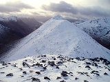
Buachaille Etive Beag (Scottish Gaelic: Buachaille Eite Beag), is a mountain
located between Glen Coe
and Glen Etive
, on the edge of Rannoch Moor
in the Scottish Highlands
. Viewed from the south in Glen Etive it forms a twin with Buachaille Etive Mòr
(the 'Great Herdsman of Etive'), from which it is separated by a bealach
at a height of about 480 metres. The mountain is often known affectionately as the "wee Buachaille", which is a literal translation of its Gaelic name.
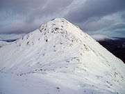
Buachaille Etive Beag forms a ridge about 3 km in length that runs in a southwest–northeast direction. It has two peaks of Munro
status: Stob Dubh and Stob Coire Raineach. The latter became a Munro in the 1997 revision of Munro's Tables, in which all tops with a topographic prominence
of more than 500 feet (152.4 m) were promoted to full Munro status.
The most common route on the mountain starts from the A82
at the head of Glen Coe. A cairn
and a sign mark the existence of a right-of-way
to Glen Etive, following the through the Lairig Eilde that separates Buachaille Etive Beag from Bidean nam Bian
. This route is followed for around 1.5 km, at which point most hillwalkers
simply head up the hillside to reach the bealach
between the two summits, which is at a height of around 750 m. From here Stob Coire Raineach lies about 0.5 km to the northeast, whilst Stob Dubh is about 2 km to the southwest. After bagging both tops, most walkers simply descend by their route of ascent. One may also reach (and descend from) the bealach by means of the Lairig Gartain, which separates Buachaille Etive Beag, from its larger sibling, Buachaille Etive Mor.
An alternative route would be to start from Glen Etive, thus allowing for a traverse
of the ridge. The southwest ridge is unrelentingly steep, and one would be obliged to arrange transport back to Glen Etive or walk an additional 4 km to return via the Lairig Eilde or Lairig Gartain.
Mountain
Image:Himalaya_annotated.jpg|thumb|right|The Himalayan mountain range with Mount Everestrect 58 14 160 49 Chomo Lonzorect 200 28 335 52 Makalurect 378 24 566 45 Mount Everestrect 188 581 920 656 Tibetan Plateaurect 250 406 340 427 Rong River...
located between Glen Coe
Glen Coe
Glen Coe is a glen in the Highlands of Scotland. It lies in the southern part of the Lochaber committee area of Highland Council, and was formerly part of the county of Argyll. It is often considered one of the most spectacular and beautiful places in Scotland, and is a part of the designated...
and Glen Etive
Glen Etive
Glen Etive is a glen in the Highlands of Scotland. The River Etive rises on the peaks surrounding Rannoch Moor, with several tributary streams coming together at the Kings House Hotel, at the head of Glen Coe. From the Kings House, the Etive flows for about 18 km, reaching the sea loch, Loch...
, on the edge of Rannoch Moor
Rannoch Moor
Rannoch Moor is a large expanse of around 50 square miles of boggy moorland to the west of Loch Rannoch, in Perth and Kinross and Lochaber, Highland, partly northern Argyll and Bute, Scotland...
in the Scottish Highlands
Scottish Highlands
The Highlands is an historic region of Scotland. The area is sometimes referred to as the "Scottish Highlands". It was culturally distinguishable from the Lowlands from the later Middle Ages into the modern period, when Lowland Scots replaced Scottish Gaelic throughout most of the Lowlands...
. Viewed from the south in Glen Etive it forms a twin with Buachaille Etive Mòr
Buachaille Etive Mòr
Buachaille Etive Mòr , generally known to climbers simply as The Buachaille or The Beuckle, is a mountain at the head of Glen Etive in the Highlands of Scotland...
(the 'Great Herdsman of Etive'), from which it is separated by a bealach
Mountain pass
A mountain pass is a route through a mountain range or over a ridge. If following the lowest possible route, a pass is locally the highest point on that route...
at a height of about 480 metres. The mountain is often known affectionately as the "wee Buachaille", which is a literal translation of its Gaelic name.
Buachaille Etive Beag forms a ridge about 3 km in length that runs in a southwest–northeast direction. It has two peaks of Munro
Munro
A Munro is a mountain in Scotland with a height over . They are named after Sir Hugh Munro, 4th Baronet , who produced the first list of such hills, known as Munros Tables, in 1891. A Munro top is a summit over 3,000 ft which is not regarded as a separate mountain...
status: Stob Dubh and Stob Coire Raineach. The latter became a Munro in the 1997 revision of Munro's Tables, in which all tops with a topographic prominence
Topographic prominence
In topography, prominence, also known as autonomous height, relative height, shoulder drop , or prime factor , categorizes the height of the mountain's or hill's summit by the elevation between it and the lowest contour line encircling it and no higher summit...
of more than 500 feet (152.4 m) were promoted to full Munro status.
The most common route on the mountain starts from the A82
A82 road
The A82 is a trunk road in Scotland. It is the principal route from Lowland Scotland to the western Scottish Highlands, running from Glasgow to Inverness, going by Loch Lomond, Glen Coe and Fort William. It is the second longest primary A-road in Scotland after the A9, which is the other...
at the head of Glen Coe. A cairn
Cairn
Cairn is a term used mainly in the English-speaking world for a man-made pile of stones. It comes from the or . Cairns are found all over the world in uplands, on moorland, on mountaintops, near waterways and on sea cliffs, and also in barren desert and tundra areas...
and a sign mark the existence of a right-of-way
Rights of way in Scotland
In Scotland a right of way is defined as any defined route over which the public has been able to pass unhindered for at least 20 years. The route must link two "public places", such as villages, churches or roads. Unlike in England and Wales there is no obligation on Scottish local authorities to...
to Glen Etive, following the through the Lairig Eilde that separates Buachaille Etive Beag from Bidean nam Bian
Bidean nam Bian
Bidean nam Bian, lying to the south of Glen Coe, Highland, Scotland, is the highest point in the former county of Argyll. It is a complex mountain, with many ridges and subsidiary peaks, one of which, Stob Coire Sgreamhach, is classified as a separate Munro....
. This route is followed for around 1.5 km, at which point most hillwalkers
Hillwalking
In the British Isles, the terms hillwalking or fellwalking are commonly used to describe the recreational outdoor activity of walking on hills and mountains, often with the intention of visiting their summits...
simply head up the hillside to reach the bealach
Mountain pass
A mountain pass is a route through a mountain range or over a ridge. If following the lowest possible route, a pass is locally the highest point on that route...
between the two summits, which is at a height of around 750 m. From here Stob Coire Raineach lies about 0.5 km to the northeast, whilst Stob Dubh is about 2 km to the southwest. After bagging both tops, most walkers simply descend by their route of ascent. One may also reach (and descend from) the bealach by means of the Lairig Gartain, which separates Buachaille Etive Beag, from its larger sibling, Buachaille Etive Mor.
An alternative route would be to start from Glen Etive, thus allowing for a traverse
Traverse (climbing)
A traverse is a lateral move or route when climbing; going mainly sideways rather than up or down. Traversing a climbing wall is a good warm-up exercise....
of the ridge. The southwest ridge is unrelentingly steep, and one would be obliged to arrange transport back to Glen Etive or walk an additional 4 km to return via the Lairig Eilde or Lairig Gartain.