
Mam Sodhail
Encyclopedia
Scotland
Scotland is a country that is part of the United Kingdom. Occupying the northern third of the island of Great Britain, it shares a border with England to the south and is bounded by the North Sea to the east, the Atlantic Ocean to the north and west, and the North Channel and Irish Sea to the...
Munro
Munro
A Munro is a mountain in Scotland with a height over . They are named after Sir Hugh Munro, 4th Baronet , who produced the first list of such hills, known as Munros Tables, in 1891. A Munro top is a summit over 3,000 ft which is not regarded as a separate mountain...
situated in the secluded country on the northern side of Glen Affric
Glen Affric
right|300px|thumb|Glen AffricGlen Affric is a glen south-west of the village of Cannich in the Highland region of Scotland, some to the west of Loch Ness. The River Affric runs along its length, passing through Loch Affric and Loch Beinn a' Mheadhoin .It used to be part of the lands of the Clan...
, some 30 kilometres east of Kyle of Lochalsh
Kyle of Lochalsh
Kyle of Lochalsh is a village on the northwest coast of Scotland, 63 miles west of Inverness. It is located at the entrance to Loch Alsh, opposite the village of Kyleakin on the Isle of Skye...
.
Overview
At 1181 metres (3874 feet) it is the second highest mountain north of the Great GlenGreat Glen
The Great Glen , also known as Glen Albyn or Glen More is a series of glens in Scotland running 100 kilometres from Inverness on the Moray Firth, to Fort William at the head of Loch Linnhe.The Great Glen follows a large geological fault known as the Great Glen Fault...
(after Càrn Eige
Carn Eige
Càrn Eige, sometimes spelt Càrn Eighe, is the highest mountain in northern Scotland . It is in the Highland council area, on the boundary between the historic counties of Inverness and Ross and Cromarty, on the former lands of the Clan Chisholm.The mountain is very remote, more than 10 km ...
) and the fourteenth highest in the United Kingdom. Càrn Eige stands just one kilometre to the north of Mam Sodhail and the two are regarded as twin mountains being roughly identical in height and appearance. They stand together above Gleann nam Fiadh (Glen of the Deer) and are linked by a high col of around 1045 metres, making the traverse of the two mountains a natural days walk. Mam Sodhail’s name translates from the Gaelic
Scottish Gaelic language
Scottish Gaelic is a Celtic language native to Scotland. A member of the Goidelic branch of the Celtic languages, Scottish Gaelic, like Modern Irish and Manx, developed out of Middle Irish, and thus descends ultimately from Primitive Irish....
as “Hill of the Barns” although other sources give it as “Breast (-shaped hill)
Breast shaped hill
A breast-shaped hill is a mountain in the shape of a human breast. Such anthropomorphic geographic features are to be found in different places of the world and in some cultures they were revered as the attributes of the Mother Goddess, like the Paps of Anu, named after Anu, an important goddess of...
of the Barns”.
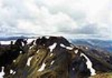
Geography and summit
Mam Sodhail is mostly grassy without too much rock, however its sheer size along with its long ridges and fine corrieCirque
Cirque may refer to:* Cirque, a geological formation* Makhtesh, an erosional landform found in the Negev desert of Israel and Sinai of Egypt*Cirque , an album by Biosphere* Cirque Corporation, a company that makes touchpads...
s together with its four "tops" named in the Munro Tables make it a first-rate mountain. The hill casts three ridges down towards Glen Affric, the most impressive of these is the east southeast ridge which has two "tops" on it, Mullach Cadha Rainich (996 metres) stands at the midpoint of the ridge which runs for four kilometres to conclude at the other “top” of Sgurr na Lapaich (1036 metres) which is the most prominent part of the mountain when viewed from Glen Affric. It has the characteristics of a separate mountain and was regarded as a Munro in the original 1891 list, with Irvine Butterfield saying, "The peak certainly does not lack character and many were disappointed to find that its original status was not restored in the seventh edition of Munros Tables". The other two ridges which form a horseshoe around the Allt Coulavie valley to the south of the summit carry the “tops” of An Tudair (1074 metres) and Creag Coire nan Each (1055 metres). The mountains western flanks fall away towards Gleann a’ Choilich which drains northwards into Loch Mullardoch.
Mam Sodhail was an important part of the Ordnance Survey
Ordnance Survey
Ordnance Survey , an executive agency and non-ministerial government department of the Government of the United Kingdom, is the national mapping agency for Great Britain, producing maps of Great Britain , and one of the world's largest producers of maps.The name reflects its creation together with...
’s initial mapping of the northern Highlands
Scottish Highlands
The Highlands is an historic region of Scotland. The area is sometimes referred to as the "Scottish Highlands". It was culturally distinguishable from the Lowlands from the later Middle Ages into the modern period, when Lowland Scots replaced Scottish Gaelic throughout most of the Lowlands...
in the 1840s and the summit carries a massive cairn
Cairn
Cairn is a term used mainly in the English-speaking world for a man-made pile of stones. It comes from the or . Cairns are found all over the world in uplands, on moorland, on mountaintops, near waterways and on sea cliffs, and also in barren desert and tundra areas...
which was used by the surveyors
Surveying
See Also: Public Land Survey SystemSurveying or land surveying is the technique, profession, and science of accurately determining the terrestrial or three-dimensional position of points and the distances and angles between them...
in their work. The cairn is hollow and its walls have to be climbed to get inside, unusually there is a visitors book inside the cairn. A few feet below the summit is the remains of a small bothy
Bothy
A bothy is a basic shelter, usually left unlocked and available for anyone to use free of charge. It was also a term for basic accommodation, usually for gardeners or other workers on an estate. Bothies are to be found in remote, mountainous areas of Scotland, northern England, Ireland, and Wales....
, complete with walls, fireplace and chimney which was formerly used by deerstalkers
Game stalker
Defined narrowly, a game stalker is a hunter who for sport, approaches close to its timid quarry before making a kill. The practice is commonly associated with the moors of Scotland where the principal quarry is red deer. However, the skill is found worldwide and is of extremely long standing...
and watchers to keep sheep and walkers off the mountain. The bothy was mentioned by Sir Hugh Munro
Hugh Munro
Sir Hugh Thomas Munro, 4th Baronet of Linderits was a Scottish mountaineer who is best known for his list of mountains in Scotland over 3,000 feet , known as the Munros....
in volume one of the Scottish Mountaineering Club
Scottish Mountaineering Club
The Scottish Mountaineering Club is Scotland's second oldest mountaineering club. Founded in 1889, in Glasgow, the private club, with about 400 members, publishes guidebooks and runs a list of Munroists.-History:At the time of the club's founding there were a number of experienced Alpinists...
Journal along with tips to circumvent it and its inhabitants. There is evidence of some quarrying south west of the main summit on the ridge to Creag Coire nan Each. There are a number of pits about three metres deep and several metres across and it is probable that this was the source of the stone for the summit cairn and the bothy.
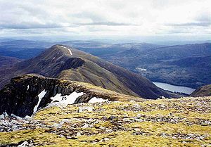
Ascents
The ascent of Mam Sodhail starts at the car park at the road end in Glen Affric at grid reference the walker can either ascend by a stalkers path up Coire Leachavie or by climbing Sgurr na Lapaich first and then following the long ESE ridge to the top of the mountain. The view from the top takes in the impressive sights of Sgurr nan CeathreamhnanSgurr nan Ceathreamhnan
Sgùrr nan Ceathreamhnan is a Scottish mountain that is situated in the remote and lonely mountainous country between Glen Affric and Glen Elchaig, some 30 kilometres east of Kyle of Lochalsh in the Highland region...
and Càrn Eige close by and the distant view is crowded by the mountains of the north west Highlands. Most walkers will take in the nearby Carn Eige as part of the walk and strong walkers may take the opportunity to climb the remote Munro of Beinn Fhionnlaidh, which lies three kilometres to the north and is difficult to access from any other place.