
Gairich
Encyclopedia
Scotland
Scotland is a country that is part of the United Kingdom. Occupying the northern third of the island of Great Britain, it shares a border with England to the south and is bounded by the North Sea to the east, the Atlantic Ocean to the north and west, and the North Channel and Irish Sea to the...
mountain situated on the southern side of Loch Quoich
Loch Quoich
Loch Quoich is a loch and reservoir situated west of Loch Garry approximately 40k m northwest of Fort William, Lochaber, Scotland...
between Glen Kingie and Glen Garry in the Lochaber
Lochaber
District of Lochaber 1975 to 1996Highland council area shown as one of the council areas of ScotlandLochaber is one of the 16 ward management areas of the Highland Council of Scotland and one of eight former local government districts of the two-tier Highland region...
district of the Highland
Highland (council area)
Highland is a council area in the Scottish Highlands and is the largest local government area in both Scotland and the United Kingdom as a whole. It shares borders with the council areas of Moray, Aberdeenshire, Perth and Kinross, and Argyll and Bute. Their councils, and those of Angus and...
Council Area, 25 kilometres north-northwest of Fort William.
Overview
With a height of 919 metres (3015 feet), Gairich qualifies as a MunroMunro
A Munro is a mountain in Scotland with a height over . They are named after Sir Hugh Munro, 4th Baronet , who produced the first list of such hills, known as Munros Tables, in 1891. A Munro top is a summit over 3,000 ft which is not regarded as a separate mountain...
by just four metres and is the 272nd ranked Munro. Despite its relatively low height the mountain is rough and quite isolated with a substantial prominence
Topographic prominence
In topography, prominence, also known as autonomous height, relative height, shoulder drop , or prime factor , categorizes the height of the mountain's or hill's summit by the elevation between it and the lowest contour line encircling it and no higher summit...
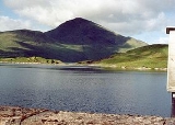
of 552 metres and is conspicuous in the view up Glen Garry. It is seen as a conical peak when viewed from the Loch Quoich dam (see picture). The mountain was initially named Scour Gairoch on the original 1891 list of Munros and is still occasionally called this, however it is now referred to generally as Gairich which translates from the Gaelic
Scottish Gaelic language
Scottish Gaelic is a Celtic language native to Scotland. A member of the Goidelic branch of the Celtic languages, Scottish Gaelic, like Modern Irish and Manx, developed out of Middle Irish, and thus descends ultimately from Primitive Irish....
as “roaring” or Peak of Yelling” and is believed to refer to the roaring of stags
Deer
Deer are the ruminant mammals forming the family Cervidae. Species in the Cervidae family include white-tailed deer, elk, moose, red deer, reindeer, fallow deer, roe deer and chital. Male deer of all species and female reindeer grow and shed new antlers each year...
in the rutting season.
Geography
Gairich has two notable corrieCirque
Cirque may refer to:* Cirque, a geological formation* Makhtesh, an erosional landform found in the Negev desert of Israel and Sinai of Egypt*Cirque , an album by Biosphere* Cirque Corporation, a company that makes touchpads...
s on its slopes. Coire Liath lies on the northern flank of the mountain. It is a kilometre across and is rimmed by crags. It is drained by the Allt a' Choire Leith which flows northwards into Loch Quoich. These lower northern slopes of the mountain formerly had a right of way which went along the southern shore of Loch Quoich, this track was submerged and lost when the loch was dammed in 1957 and the water level was raised by 100 feet as part of the hydro-electric scheme
Hydropower
Hydropower, hydraulic power, hydrokinetic power or water power is power that is derived from the force or energy of falling water, which may be harnessed for useful purposes. Since ancient times, hydropower has been used for irrigation and the operation of various mechanical devices, such as...
in the Highlands. Loch
Loch
Loch is the Irish and Scottish Gaelic word for a lake or a sea inlet. It has been anglicised as lough, although this is pronounced the same way as loch. Some lochs could also be called a firth, fjord, estuary, strait or bay...
an Doire Meall an Eilein, a small lake approximately 500 metres in length stands on the northern flanks of Gairich around the 400 metre contour. The eastern slopes of the mountain has the smaller Coire Thollaidh which also drains north into the loch. Gairich is made up of three distinct ridges, the NE and NW ridges form the flanks of Coire Liath and descend to Loch Quoich. Either of these ridges could be used for ascent by walkers approaching the mountain by canoe
Canoe
A canoe or Canadian canoe is a small narrow boat, typically human-powered, though it may also be powered by sails or small electric or gas motors. Canoes are usually pointed at both bow and stern and are normally open on top, but can be decked over A canoe (North American English) or Canadian...
across the loch. The eastern ridge descends for four kilometres from the summit ending near the Quoich dam and is used in ascending the mountain from that direction.
Although the mountain is seen as a conical peak when viewed from the Quoich dam this is quite misleading as the actual summit plateau extends westward for almost two kilometres culminating in the subsidiary top of Gairich Beag with a height of 730 metres before descending into the a' Mhaingir glen. Gairich is in fact the first peak in a chain of hills which extends westwards over the adjoining Munro of Sgurr Mòr to terminate at Sgurr na Cìche
Sgurr na Ciche
Sgurr na Cìche is a mountain in the Knoydart region, in the west of Scotland. It lies on the edge of Knoydart in an area known as the Rough Bounds of Knoydart....
in the remote wilderness of Knoydart. The southern flank of the mountain descends steeply into the lonely Glen Kingie, this precipitous slope has a large impressive gully on it which is drained by the Allt am Fhamhair. Glen Kingie itself can be a difficult barrier when approaching Gairich from the south with the River Kingie being an impossible obstacle when it is in spate and needing wading at other times because of the absence of bridges. The Kinbreack bothy
Bothy
A bothy is a basic shelter, usually left unlocked and available for anyone to use free of charge. It was also a term for basic accommodation, usually for gardeners or other workers on an estate. Bothies are to be found in remote, mountainous areas of Scotland, northern England, Ireland, and Wales....
in Glen Kingie is a useful base for climbing the mountains in this area.
Ascents
The usual ascent of Gairich starts at the car park at the Loch Quoich dam at grid reference . From there the dam wall is crossed and a path is picked up which goes south for 2.5 kilometres to reach the lower part of the east ridge. It is then a five kilometre climb up the ridge to the highest point, crossing the subsidiary top of Bac nam Foid (584 metres) on the way. The final section to the summit is a steep climb with one tricky narrow bit. It is also possible to climb the mountain from the south, starting at the road end by Loch ArkaigLoch Arkaig
Loch Arkaig is a body of water in Lochaber, Scotland, to the west of the Great Glen. It is approximately 12 miles in length and lies 140 feet above sea level, the maximum depth is some 300 feet....
at Strathan at grid reference and following an old right of way to Tomdoun in Glen Garry as far as the Kinbreack bothy in Glen Kingie. The best place to wade the Kingie is near the bothy, Gairich can then be ascended by its western flank passing over Gairich Beag to reach the summit.