
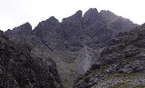
Sgurr nan Gillean
Encyclopedia
Cuillin
This article is about the Cuillin of Skye. See Rùm for the Cuillin of Rùm.The Cuillin are a range of rocky mountains located on the Isle of Skye in Scotland. The true Cuillin are also known as the Black Cuillin to distinguish them from the Red Hills across Glen Sligachan...
range on the Isle of Skye in Scotland
Scotland
Scotland is a country that is part of the United Kingdom. Occupying the northern third of the island of Great Britain, it shares a border with England to the south and is bounded by the North Sea to the east, the Atlantic Ocean to the north and west, and the North Channel and Irish Sea to the...
. With a height of 964 m (3162 feet) it is one of eleven Munro
Munro
A Munro is a mountain in Scotland with a height over . They are named after Sir Hugh Munro, 4th Baronet , who produced the first list of such hills, known as Munros Tables, in 1891. A Munro top is a summit over 3,000 ft which is not regarded as a separate mountain...
s on the Cuillin ridge.
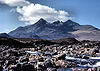
Sgurr nan Gillean is the mountain closest to Sligachan
Sligachan
Sligachan is a small settlement on Skye, Scotland. It is close to the Cuillin mountains and provides a good viewpoint for seeing the Black Cuillin mountains.-Amenities:...
, and its impressive triangular profile is visible behind the Sligachan hotel, making it perhaps the most recognised peak in the Cuillin range.
Routes
The most popular route of ascent, known as the Tourist Route, follows a path leading south from Sligachan, crossing a burnBurn (stream)
In Scotland, North East England and some parts of Ireland and New Zealand, burn is a name for watercourses from large streams to small rivers. The term is also used in lands settled by the Scots and Northern English in other countries, notably in Otago, New Zealand, where much of the naming was...
known the Allt Dearg Beag (small red burn). The route continues up into a corrie
Cirque
Cirque may refer to:* Cirque, a geological formation* Makhtesh, an erosional landform found in the Negev desert of Israel and Sinai of Egypt*Cirque , an album by Biosphere* Cirque Corporation, a company that makes touchpads...
, the Coire Rhiabhach. The ascent of the coire headwall is on loose rock and scree. The continuation up the southeast ridge to the summit is exposed, and calls for scrambling
Scrambling
Scrambling is a method of ascending rocky faces and ridges. It is an ambiguous term that lies somewhere between hillwalking and rock climbing. It is often distinguished from hillwalking by defining a scramble as a route where hands must be used in the ascent...
ability. The path up is very narrow so calls for single file when a party ascends. The top is a ridge which must be traversed to reach the final summit, and like the climb, needs some scrambling ability. All sides are very exposed, and extra care is needed if mist descends. The small airy summit platform is surprisingly smooth and flat with outstanding views.
An alternative route is the north ridge, known as Pinnacle Ridge, which is a rock climb that requires a climber to have a rope and harness and be capable of abseiling, unless the third pinnacle is omitted by bypassing on the east side. While rope is a sensible option for the moderate climb up Gillean, it is not required for Knight's Peak if the correct route is taken. The highest of the pinnacles is known as "The Knights Peak" and is a designated Top. To reach the base of the Pinnacle Ridge a climber starts in the same place as for the route described above but instead of crossing the burn continues up hill on the right hand side until just below the start of the Basteir gorge when the stream exiting the gorge is crossed to reach the base of the lowest pinnacle.
Another alternative route of ascent or descent is the West Ridge. It leads from the summit down to a bealach separating Sgurr nan Gillean from Am Basteir
Am Basteir
Am Basteir is a mountain in the northern Cuillin range on the Isle of Skye in Scotland. It is 934 metres high and classed as a Munro...
. About two-thirds of the way down, there is a particularly narrow and exposed section, which forms the remains of a large upright rock, known as the Gendarme which broke away due to the effects of frost shatter during the winter of 1986/87, leaving only the base. The narrow section can be avoided by abseiling down (or climbing up) a gully, known as Nicholson's Chimney, on the north side of the ridge.