
Sgairneach Mhòr
Encyclopedia
Scotland
Scotland is a country that is part of the United Kingdom. Occupying the northern third of the island of Great Britain, it shares a border with England to the south and is bounded by the North Sea to the east, the Atlantic Ocean to the north and west, and the North Channel and Irish Sea to the...
mountain which lies in a group of seven Munro
Munro
A Munro is a mountain in Scotland with a height over . They are named after Sir Hugh Munro, 4th Baronet , who produced the first list of such hills, known as Munros Tables, in 1891. A Munro top is a summit over 3,000 ft which is not regarded as a separate mountain...
s near the summit of the Pass of Drumochter
Pass of Drumochter
The Pass of Drumochter is the main mountain pass between the northern and southern central Scottish Highlands. The A9 road passes through here, as does the Highland Main Line, the railway between Inverness and the south of Scotland...
and are known as the Drumochter mountains or informerly as the “A9 Munros”. The mountain is situated 13 km SSW of Dalwhinnie
Dalwhinnie
Dalwhinnie "Meeting Place" is a small village in the Scottish Highlands.-Location:Dalwhinnie sits at an altitude of 351 m. It is one of the coldest villages in the UK, having an average annual temperature of 6.5oC, making it suitable for winter walking and mountaineering.It is north of Drumochter,...
and four km east of the large Loch Ericht
Loch Ericht
Loch Ericht is a freshwater loch on the border between Perth and Kinross and the Highlands Council areas of Scotland. It is situated at a height of 351 metres above sea level and has a north-east to south-west orientation. The village of Dalwhinnie lies at the north east end of the loch...
.
Overview
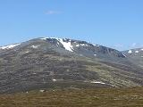
Sgairneach Mhòr lies to the west of the A9 road in area of high ground which was historically called the Druim Uachdair (the ridge of the upper ground), it reaches a height of 991 metres (3251 feet), making it the 155th highest MunroMunro
A Munro is a mountain in Scotland with a height over . They are named after Sir Hugh Munro, 4th Baronet , who produced the first list of such hills, known as Munros Tables, in 1891. A Munro top is a summit over 3,000 ft which is not regarded as a separate mountain...
it also qualifies as a Marilyn
Marilyn (hill)
A Marilyn is a mountain or hill in the United Kingdom, Republic of Ireland or Isle of Man with a relative height of at least 150 metres , regardless of absolute height or other merit...
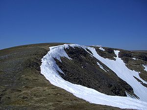
, it is well seen from the Pass of Drumochter showing off its impressive north facing corrie Coire Creagach which holds snow well into the spring. This notable rocky corrie gives the mountain its name which translates from the Gaelic
Scottish Gaelic language
Scottish Gaelic is a Celtic language native to Scotland. A member of the Goidelic branch of the Celtic languages, Scottish Gaelic, like Modern Irish and Manx, developed out of Middle Irish, and thus descends ultimately from Primitive Irish....
as “Big Rocky Hillside” and this underlines the fact that Sgairneach Mhòr is the only hill in the group with any significant stony areas on its surface and makes it the most visually striking of the Drumochter hills.
Geography
Sgairneach Mhòr has extensive southern slopes which include the subsidiary tops of Màm Bàn (919 metres) and Meallan Buidhe (879 metres) and descend to the glen of the Allt Shallainn which is the main tributary of Loch Garry. Two distinct ridges go north and east from the summit enclosing Coire Creagach which is rocky but not overly steep giving a sporting scrambleScrambling
Scrambling is a method of ascending rocky faces and ridges. It is an ambiguous term that lies somewhere between hillwalking and rock climbing. It is often distinguished from hillwalking by defining a scramble as a route where hands must be used in the ascent...
to the summit. The summit of the mountain is a SW-NE orientated plateau with the highest point never in doubt, standing at the NE end close to the edge of Coire Creagach and being marked by an OS
Ordnance Survey
Ordnance Survey , an executive agency and non-ministerial government department of the Government of the United Kingdom, is the national mapping agency for Great Britain, producing maps of Great Britain , and one of the world's largest producers of maps.The name reflects its creation together with...
trig point
Trig point
A triangulation station, also known as a triangulation pillar, trigonometrical station, trigonometrical point, trig station, trig beacon or trig point, and sometimes informally as a trig, is a fixed surveying station, used in geodetic surveying and other surveying projects in its vicinity...
surrounded by a low stone built wind shelter. The summit of the mountain was given as 500 metres SW of the present position in the original Munro Tables of 1891 but this must have been a map reading error as this point (marked by a cairn) measures only 963 metres in altitude almost 30 metres lower than the true summit.
The eastern ridge connects to the adjacent Corbett of The Sow of Atholl
The Sow of Atholl
The Sow of Atholl is a Scottish hill which is situated 27 kilometres WNW of the town of Blair Atholl in Perth and Kinross council area...
, and is narrow near the summit as it goes round the rim of Coire Creagach before broadening as it drops in easy angled slopes to a col
Mountain pass
A mountain pass is a route through a mountain range or over a ridge. If following the lowest possible route, a pass is locally the highest point on that route...
with a height of approximately 650 metres. This eastern ridge is one of the main routes of ascent. The NE ridge is another possible route of ascent from upper Coire Dhomhain although its slopes are steep and rough in places. The hills western flank consist of broad slopes which contour around the head of Coire Dhomhain and descend to a col which links to the adjacent Munro of Beinn Udlamain
Beinn Udlamain
Beinn Udlamain is a Scottish mountain which stands just to the west of the summit of the Pass of Drumochter and east of Loch Ericht, some 30 km west-northwest of the village of Blair Atholl. The mountain’s summit stands on the border between the Highland and Perth and Kinross council...
. All drainage from the mountain goes south via the rivers Garry and Tummel
River Tummel
The River Tummel is a river in Perth and Kinross, Scotland. Discharging from Loch Rannoch, it flows east to a point near the Falls of Tummel, where it bends to the southeast, a direction which it maintains until it falls into the River Tay, just below Logierait, after a course of from its source...
to join the drainage basin of the River Tay
River Tay
The River Tay is the longest river in Scotland and the seventh-longest in the United Kingdom. The Tay originates in western Scotland on the slopes of Ben Lui , then flows easterly across the Highlands, through Loch Dochhart, Loch Lubhair and Loch Tay, then continues east through Strathtay , in...
and reaching the east coast at the Firth of Tay
Firth of Tay
The Firth of Tay is a firth in Scotland between the council areas of Fife, Perth and Kinross, the City of Dundee and Angus, into which Scotland's largest river in terms of flow, the River Tay, empties....
.
Ascents and view
The direct ascent of Sgairneach Mhòr is not a difficult walk as the starting point is at the summit of the Drumochter Pass on the A9 road and has a starting altitude of 462 metres. The walk crosses the railway and ascends Coire Dhomhain on a good track on the north bank of the Allt Coire Dhomhain. After approximately two km the track is left and the burn is crossed (no bridge) to its southern bank. It is then a walk south through pathless heather to reach the eastern ridge which is followed to the summit. If the burn is in spate then an alternative is to walk higher up into Coire Dhomhain and then ascend by the steeper northern ridge.The ascent of Sgairneach Mhòr can be combined with any of the other three hills which stand around the glen of the Allt Coire Dhomhain. The SMC
Scottish Mountaineering Club
The Scottish Mountaineering Club is Scotland's second oldest mountaineering club. Founded in 1889, in Glasgow, the private club, with about 400 members, publishes guidebooks and runs a list of Munroists.-History:At the time of the club's founding there were a number of experienced Alpinists...
s Munro handbook recommends climbing it with Beinn Udlamain, however the high starting altitude at Drumochter Pass means a complete traverse around the valley including the hills of The Sow of Atholl, Sgairneach Mhòr, Beinn Udlamain and A' Mharconaich
A' Mharconaich
A' Mharconaich is a Scottish mountain that is located 29 km WNW of Blair Atholl in the Highland council area. It is in a group of mountains that lie west of the A9 road near the summit of the Pass of Drumochter and are known accordingly as the Drumochter Hills...
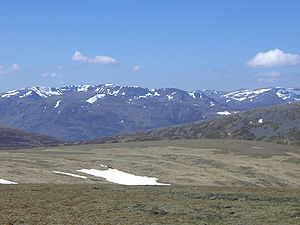
is not an over strenuous day. The highlight of the view from the summit is to the west where there is an excellent view of the Ben Alder
Ben Alder
Ben Alder is the highest mountain in the remote area of the Scottish Highlands between Loch Ericht and Glen Spean. The vast summit plateau is home of one of Britain's highest bodies of standing water, Lochan a' Garbh Coire. It is the 25th highest Munro, and due to its remote location, one of the...
group of mountains.