
Ben Oss
Encyclopedia

Scotland
Scotland is a country that is part of the United Kingdom. Occupying the northern third of the island of Great Britain, it shares a border with England to the south and is bounded by the North Sea to the east, the Atlantic Ocean to the north and west, and the North Channel and Irish Sea to the...
mountain situated in the Stirling Council area, six kilometres south west of the village of Tyndrum
Tyndrum
Tyndrum is a small village in Scotland. Its Gaelic name translates as "the house on the ridge". It lies in Strathfillan, at the southern edge of Rannoch Moor.The village is notable mainly for being at an important crossroads of transport routes...
within the Loch Lomond and the Trossachs National Park
Loch Lomond and the Trossachs National Park
Loch Lomond and The Trossachs National Park is a national park in Scotland centred on Loch Lomond, and includes several ranges of hills, the Trossachs being the most famous...
.
Overview
Ben Oss reaches a height of 1029 metres (3376 feet) and qualifies as a MunroMunro
A Munro is a mountain in Scotland with a height over . They are named after Sir Hugh Munro, 4th Baronet , who produced the first list of such hills, known as Munros Tables, in 1891. A Munro top is a summit over 3,000 ft which is not regarded as a separate mountain...
and a Marilyn
Marilyn (hill)
A Marilyn is a mountain or hill in the United Kingdom, Republic of Ireland or Isle of Man with a relative height of at least 150 metres , regardless of absolute height or other merit...
. It stands in a group of hills in the Cononish valley to the west of Tyndrum which consists of three other Munros (Ben Lui
Ben Lui
Ben Lui is a mountain in the southern Highlands of Scotland, at the head of Glen Fyne. It has five well-defined ridges radiating out from the summit...
, Beinn Dubhchraig
Beinn Dubhchraig
Beinn Dubhchraig is a Scottish mountain that is situated eight kilometres west of Crianlarich in the northern part of the Loch Lomond and the Trossachs National Park.- Overview :...
and Beinn a' Chleibh) and the Corbett Beinn Chùirn
Beinn Chùirn
Beinn Chùirn is a Scottish hill situated five kilometres west-southwest of Tyndrum, it stands on the border of Stirlingshire and Perthshire at the northern extremity of the Loch Lomond and the Trossachs National Park.- Overview :...
. When viewed from the north or south it is seen as a distinct pointed hill in contrast to its more bulky neighbour Beinn Dubhchraig, with which it is usually climbed.
The mountain is quite rocky and craggy being composed of mica schist rock. The hills name has two possible meanings in the Gaelic
Scottish Gaelic language
Scottish Gaelic is a Celtic language native to Scotland. A member of the Goidelic branch of the Celtic languages, Scottish Gaelic, like Modern Irish and Manx, developed out of Middle Irish, and thus descends ultimately from Primitive Irish....
with guide books being divided on the subject. “Os” can mean an elk
Elk
The Elk is the large deer, also called Cervus canadensis or wapiti, of North America and eastern Asia.Elk may also refer to:Other antlered mammals:...
or a loch
Loch
Loch is the Irish and Scottish Gaelic word for a lake or a sea inlet. It has been anglicised as lough, although this is pronounced the same way as loch. Some lochs could also be called a firth, fjord, estuary, strait or bay...
outlet, with a lochan and a stream with the same name in the immediate vicinity it implies that the area around Ben Oss was where elk were found before they were hunted to extinction.
Geography
Ben Oss is especially craggy on its northern face, falling away steeply to the Cononish valley and barring any direct approach from this direction. It has two main ridges which connect to the adjacent Munros of Ben Lui and Beinn Dubhchraig and walkers usually arrive at the mountains summit along either of these. One ridge goes north east, east and then south east to form a curving edge around CoireCirque
Cirque may refer to:* Cirque, a geological formation* Makhtesh, an erosional landform found in the Negev desert of Israel and Sinai of Egypt*Cirque , an album by Biosphere* Cirque Corporation, a company that makes touchpads...
Garbh connecting to Beinn Dubhchraig at the Bealach
Mountain pass
A mountain pass is a route through a mountain range or over a ridge. If following the lowest possible route, a pass is locally the highest point on that route...
Buidhe with a height of 779 metres. Coire Garbh has Loch Oss lying within its recesses, a body of water measuring roughly 500 by 300 metres. Coire Buidhe stands on the northern side of this eastern ridge, this has a steep headwall and descents north from the bealach to the Cononish valley are not recommended.
Ben Oss’s other ridge goes south west to a col
Mountain pass
A mountain pass is a route through a mountain range or over a ridge. If following the lowest possible route, a pass is locally the highest point on that route...
at the head of Coire Laoigh with a height of 687 metres which links to Ben Lui. Ben Oss’ southern slopes drop less steeply to Glen Falloch and the land at the head of Loch Lomond
Loch Lomond
Loch Lomond is a freshwater Scottish loch, lying on the Highland Boundary Fault. It is the largest lake in Great Britain by surface area. The lake contains many islands, including Inchmurrin, the largest fresh-water island in the British Isles, although the lake itself is smaller than many Irish...
. Ben Oss lies on the drainage divide of Scotland, all rainfall that falls on the northern slopes drains to the Cononish valley which forms the headwaters of the River Tay
River Tay
The River Tay is the longest river in Scotland and the seventh-longest in the United Kingdom. The Tay originates in western Scotland on the slopes of Ben Lui , then flows easterly across the Highlands, through Loch Dochhart, Loch Lubhair and Loch Tay, then continues east through Strathtay , in...
and eventually goes to the east coast. Drainage from the southern slopes goes via Glen Falloch and Loch Lomond to reach the sea at the west coast at the Firth of Clyde
Firth of Clyde
The Firth of Clyde forms a large area of coastal water, sheltered from the Atlantic Ocean by the Kintyre peninsula which encloses the outer firth in Argyll and Ayrshire, Scotland. The Kilbrannan Sound is a large arm of the Firth of Clyde, separating the Kintyre Peninsula from the Isle of Arran.At...
.
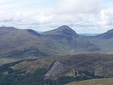
Ben Oss alongside Ben Lui
Ben Lui
Ben Lui is a mountain in the southern Highlands of Scotland, at the head of Glen Fyne. It has five well-defined ridges radiating out from the summit...
stand at the head of Glen Fyne, a contuation of the sea loch, Loch Fyne
Loch Fyne
Loch Fyne is a sea loch on the west coast of Argyll and Bute, Scotland. It extends inland from the Sound of Bute, making it the longest of the sea lochs...
at 40 miles long in Argyll and Bute
Argyll and Bute
Argyll and Bute is both one of 32 unitary council areas; and a Lieutenancy area in Scotland. The administrative centre for the council area is located in Lochgilphead.Argyll and Bute covers the second largest administrative area of any Scottish council...
.
Ascents
Because of a lack of good access paths from the south (Glen Falloch), Ben Oss is usually climbed from the area just south of Tyndrum, with the usual start being at Dalrigh (grid reference ) on the A82 roadA82 road
The A82 is a trunk road in Scotland. It is the principal route from Lowland Scotland to the western Scottish Highlands, running from Glasgow to Inverness, going by Loch Lomond, Glen Coe and Fort William. It is the second longest primary A-road in Scotland after the A9, which is the other...
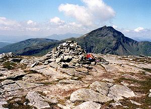
. Many guide books recommend climbing Ben Oss with Beinn Dubhchraig from Dalrigh and this allows for a less steep approach over Dubhchraig and then continuing to Ben Oss via the Bealach Buidhe. A circular walk around the head of the Cononish valley can be continued over Ben Lui and Beinn Chuirn to finish again at Dalrigh. The summit of the mountain is flattish and the medium size cairn stands on an area of large slabby rocks interspersed with grass. The summit has a prominence of 342 metres and gives a fine vista of the southern highlands, it is a good place to admire the craggy eastern face of neighbouring Ben Lui.