

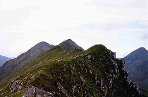
Sgurr na Ciste Dhuibhe
Encyclopedia
Scotland
Scotland is a country that is part of the United Kingdom. Occupying the northern third of the island of Great Britain, it shares a border with England to the south and is bounded by the North Sea to the east, the Atlantic Ocean to the north and west, and the North Channel and Irish Sea to the...
mountain situated on the northern side of Glen Shiel
Glen Shiel
Glen Shiel is a glen in the Northwest Highlands of Scotland.The glen runs approximately 9 miles from north-west to south-east, from sea level at the village of Shiel Bridge and Loch Duich to the Cluanie Inn at the western end of Loch Cluanie and the start of Glenmoriston.W. H...
, 27 kilometres south east of Kyle of Lochalsh
Kyle of Lochalsh
Kyle of Lochalsh is a village on the northwest coast of Scotland, 63 miles west of Inverness. It is located at the entrance to Loch Alsh, opposite the village of Kyleakin on the Isle of Skye...
in the Highland
Highland (council area)
Highland is a council area in the Scottish Highlands and is the largest local government area in both Scotland and the United Kingdom as a whole. It shares borders with the council areas of Moray, Aberdeenshire, Perth and Kinross, and Argyll and Bute. Their councils, and those of Angus and...
council area.
Overview
Sgùrr na Ciste Duibhe reaches a height of 1027 metres (3369 feet) making it MunroMunro
A Munro is a mountain in Scotland with a height over . They are named after Sir Hugh Munro, 4th Baronet , who produced the first list of such hills, known as Munros Tables, in 1891. A Munro top is a summit over 3,000 ft which is not regarded as a separate mountain...
number 104 in terms of height. It is one of three Munros which make up the Five Sisters of Kintail
Kintail
Kintail is an area of mountains in the Northwest Highlands of Scotland. It consists of the mountains to the north of Glen Shiel and the A87 road between the heads of Loch Duich and Loch Cluanie; its boundaries, other than Glen Shiel, are generally taken to be the valleys of Strath Croe and Gleann...
group of hills (the others being Sgùrr Fhuaran
Sgurr Fhuaran
Sgùrr Fhuaran is a Scottish mountain that is situated on the northern side of Glen Shiel, east south east of Kyle of Lochalsh.- Overview :...
and Sgùrr na Càrnach
Sgurr na Càrnach
Sgùrr na Càrnach is a Scottish mountain situated on the northern side of Glen Shiel, 24 kilometres south east of Kyle of Lochalsh. The mountain is part of one of the best views in the Western Highlands as it is one of three mountains which make up the Five Sisters of Kintail...
) and is often climbed as part of the walk which takes in the full Five Sisters ridge. The mountain is not particularly photogenic and it is difficult to get a good impression of it from the A87 road
A87 road
The A87 is a major road in the Highland region of Scotland.It runs west from its junction with the A82 road at Invergarry , along the north shores of Loch Garry and Loch Cluanie, then down through Glen Shiel and along Loch Duich to Kyle of Lochalsh before crossing the Skye Bridge to Kyleakin,...
because of the steepness of its slopes as they fall into Glen Shiel.
The hill's Gaelic
Scottish Gaelic language
Scottish Gaelic is a Celtic language native to Scotland. A member of the Goidelic branch of the Celtic languages, Scottish Gaelic, like Modern Irish and Manx, developed out of Middle Irish, and thus descends ultimately from Primitive Irish....
name translates as the Peak of the Black Chest or Coffin. The meaning of the name is unsure but it is thought to refer to an unusual deep rocky hollow near the summit which lies between the main ridge and a false crest. This can be dangerous in mist or snow conditions. Other sources say that the name refers to the deep hollow of the Allt Dearg on the hills south west slope. The mountain should not be confused with another Munro called Ciste Dhubh
Ciste Dhubh
Ciste Dhubh is a mountain situated in the Scottish Highlands between Glen Shiel and Glen Affric. It is a long distance from any centres of population, with Kyle of Lochalsh being almost 30 kilometres away to the west north-west.- Overview :...
which lies just 7 km to the east.
Geography and history
Sgùrr na Ciste Duibhe’s south face is one of the steepest and highest grassy mountainsides in Scotland as it drops almost 1000 metres in a distance of 1.5 kilometres to the valley bottom in Glen Shiel. The average angle of this hillside is 34 degrees, with a maximum of around 40 degrees. The mountain’s northern flank falls in crags into CoireCirque
Cirque may refer to:* Cirque, a geological formation* Makhtesh, an erosional landform found in the Negev desert of Israel and Sinai of Egypt*Cirque , an album by Biosphere* Cirque Corporation, a company that makes touchpads...
Domhain (Deep Corrie) while to the west a ridge connects to the adjoining Munro of Sgùrr na Carnach. The ridge continues to the east going down to the Bealach an Lapain (The Easy Pass) before climbing to the adjacent Munro of Sàileag
Sàileag
Sàileag is Scottish mountain located on the northern side of Glen Shiel, 27 kilometres south east of Kyle of Lochalsh.-Overview:It lies just to the east of the famous Five Sisters of Kintail group of hills to which it is connected by the Bealach an Lapain...
.
Sgùrr na Ciste Duibhe has a subsidiary peak which is listed in the Munros Tables, Sgùrr nan Spainteach (Peak of the Spaniards) which reaches a height of 990 metres is situated 600 metres east of the main summit. The peak's unusual name derives from the Battle of Glen Shiel
Battle of Glen Shiel
The Battle of Glen Shiel was a battle in Glen Shiel, in the West Highlands of Scotland on 10 June 1719, between British government troops and an alliance of Jacobites and Spaniards, resulting in a victory for the government forces. It was the last close engagement of British and foreign troops on...
which took place on the southern slopes of the mountain in 1719. 300 Spanish troops fought a brave rearguard action in the battle on the side of the defeated Jacobite
Jacobitism
Jacobitism was the political movement in Britain dedicated to the restoration of the Stuart kings to the thrones of England, Scotland, later the Kingdom of Great Britain, and the Kingdom of Ireland...
rebels and the peak was named by locals in their honour. The western flank of Sgùrr nan Spainteach has an unexpected 10 metre vertical drop as the walker traverses the ridge to the main summit and requires some awkward scrambling. The steep south west slopes of Sgùrr na Ciste Duibhe have a large boulder lying on them known as "Prince Charlie's Stone", this is where Bonnie Prince Charlie
Charles Edward Stuart
Prince Charles Edward Louis John Casimir Sylvester Severino Maria Stuart commonly known as Bonnie Prince Charlie or The Young Pretender was the second Jacobite pretender to the thrones of Great Britain , and Ireland...
spent a red hot day in the summer of 1746 hiding from English troops. At the time he had a £30,000 bounty on his head after fleeing after the Battle of Culloden
Battle of Culloden
The Battle of Culloden was the final confrontation of the 1745 Jacobite Rising. Taking place on 16 April 1746, the battle pitted the Jacobite forces of Charles Edward Stuart against an army commanded by William Augustus, Duke of Cumberland, loyal to the British government...
.