
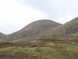
Meall na Teanga
Encyclopedia
Scotland
Scotland is a country that is part of the United Kingdom. Occupying the northern third of the island of Great Britain, it shares a border with England to the south and is bounded by the North Sea to the east, the Atlantic Ocean to the north and west, and the North Channel and Irish Sea to the...
mountain located in the Highland
Highland (council area)
Highland is a council area in the Scottish Highlands and is the largest local government area in both Scotland and the United Kingdom as a whole. It shares borders with the council areas of Moray, Aberdeenshire, Perth and Kinross, and Argyll and Bute. Their councils, and those of Angus and...
council area. 11 kilometres north of Spean Bridge
Spean Bridge
Spean Bridge is a village, in the Highland region of Scotland.The village takes its name from the Highbridge over the River Spean on General Wade's military road between Fort William and Fort Augustus, and not from Telford's bridge of 1819 which carries the A82 over the river at the heart of the...
.
Overview
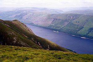
Meall na Teanga is situated on the northern side of Loch LochyLoch Lochy
Loch Lochy is a large freshwater loch in Lochaber, Highland, Scotland. With a mean depth of , it is the third deepest loch of Scotland.-Geography:...
and is closely associated with the adjacent Munro
Munro
A Munro is a mountain in Scotland with a height over . They are named after Sir Hugh Munro, 4th Baronet , who produced the first list of such hills, known as Munros Tables, in 1891. A Munro top is a summit over 3,000 ft which is not regarded as a separate mountain...
of Sròn a' Choire Ghairbh
Sròn a' Choire Ghairbh
Sròn a’ Choire Ghairbh is a Scottish mountain situated on the northern side of Loch Lochy, 13 kilometres north of Spean Bridge in the Highland Council area.-Overview:...
which lies two kilometres to the north across the Cam Bealach. The two mountains are usually ascended together. Meall na Teanga is seen prominently from the A82 road
A82 road
The A82 is a trunk road in Scotland. It is the principal route from Lowland Scotland to the western Scottish Highlands, running from Glasgow to Inverness, going by Loch Lomond, Glen Coe and Fort William. It is the second longest primary A-road in Scotland after the A9, which is the other...
on the opposite bank of Loch Lochy showing steep slopes which have the conifer plantations of the South Laggan Forest below the 300 metre contour.
The hill just attains Munro status by four metres, reaching a height of 918 metres (3012 feet) and is the 275th highest Munro. In the original Munro Tables of 1891 Meall na Teana was listed as a subsidiary “Top” of Sròn a' Choire Ghairbh but was promoted to Munro status when the tables were next updated in 1921, despite continuing doubts whether it had sufficient height. The hills name translates from the Gaelic
Scottish Gaelic language
Scottish Gaelic is a Celtic language native to Scotland. A member of the Goidelic branch of the Celtic languages, Scottish Gaelic, like Modern Irish and Manx, developed out of Middle Irish, and thus descends ultimately from Primitive Irish....
as “Hill of the Tongue”. This refers to one of the hills ridges either the long tongue like western ridge which curves round two fine corries
Cirque
Cirque may refer to:* Cirque, a geological formation* Makhtesh, an erosional landform found in the Negev desert of Israel and Sinai of Egypt*Cirque , an album by Biosphere* Cirque Corporation, a company that makes touchpads...
or the steep buttressing spur which rises from the loch to the summit. The hill is sometimes referred to by its informal moniker of “Tango”.
Geography
Meall na Teanga is made up of a series of short ridges and one longer one and has three fine corries on its slopes. The longer western ridge runs for two kilometres before dropping down steep grassy slopes to the head of Gleann Cia-aig. It runs along the rim of two large north facing corries. Coire Odhar Mor and Coire Odhar Beag are both steep and craggy and their streams form the headwaters of the Abhainn Chia-aig which flows west then south around the mountain to join the River Arkaig in the Great GlenGreat Glen
The Great Glen , also known as Glen Albyn or Glen More is a series of glens in Scotland running 100 kilometres from Inverness on the Moray Firth, to Fort William at the head of Loch Linnhe.The Great Glen follows a large geological fault known as the Great Glen Fault...
. The shorter north east ridge goes over the lesser top of Meall Dubh (839 metres) before descending to the top of the Cam Beallach which links it to the adjoining Munro of Sròn a' Choire Ghairbh.
In all, Meall na Teanga has three subsidiary tops, none of which has sufficient altitude to be regarded as Munro “Tops”. In addition to the already mentioned Meall Dubh, there is Meall Odhar (872 metres) which stands on the western ridge above Coire Odhar Mòr while Meall Coire Lochain (907 metres) stands 600 metres south west of the summit above the hills third corrie Coire Lochain which has a small lochan within it. All drainage from the mountain finds its way to Loch Lochy and then to the west coast via Loch Linnhe
Loch Linnhe
Loch Linnhe is a sea loch on the west coast of Scotland....
.
Ascents
The most popular ascent of Meall na Teanga is from the top of the Cam Beallach pass, from here an ascent of the adjacent Sròn a' Choire Ghairbh can also be done. The Cam Beallach can be approached from the south from the car park at the Cia-aig waterfall on the B8005 at grid reference , however the approach from the north east starting at Laggan Locks just off the A82 at grid reference is now more popular now that the track to the pass through the South Laggan Forest has been cleared of logging debris by the Forestry CommissionForestry Commission
The Forestry Commission is a non-ministerial government department responsible for forestry in Great Britain. Its mission is to protect and expand Britain's forests and woodlands and increase their value to society and the environment....
. A more interesting ascent from the Cia-aig waterfall can be undertaken by climbing the hills western ridge from the head of Gleann Cia-aig, this route gives the opportunity to appreciate the corries on that ridge. The summit is marked by cairn of boulders and gives views across the Great Glen towards the Grey Corries, the Aonachs
Aonach Beag
Aonach Beag is a mountain in the Highlands of Scotland. It is located about 3 km east of Ben Nevis on the north side of Glen Nevis, near the town of Fort William...
and Ben Nevis
Ben Nevis
Ben Nevis is the highest mountain in the British Isles. It is located at the western end of the Grampian Mountains in the Lochaber area of the Scottish Highlands, close to the town of Fort William....
.