

Expansion of Russia 1500–1800
Encyclopedia
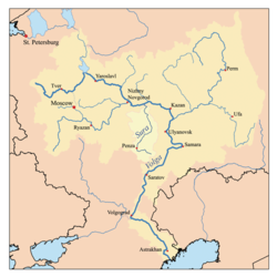
In the absence of a good map, locations will be given as approximately so many kilometers directly south of Moscow, and then so many kilometers east or west of that line. Thus, Kiev is about 600 south and 500 west, while Perekop at the head of the Crimean peninsula is 1100s and 250w. For contrast, France is not quite 1000 kilometers from north to south and Moscow is about 1000 kilometers south of the White Sea. Since these numbers are estimates, they should not be cited or copied.
Pre-History
The steppe first appears in written history about 600 BC with the founding of Greek colonies along the north coast of the Black Sea. These cities traded Greek goods for Scythian grain. The Scythians were replaced as a ruling group by the SarmatiansSarmatians
The Iron Age Sarmatians were an Iranian people in Classical Antiquity, flourishing from about the 5th century BC to the 4th century AD....
, Goths
Goths
The Goths were an East Germanic tribe of Scandinavian origin whose two branches, the Visigoths and the Ostrogoths, played an important role in the fall of the Roman Empire and the emergence of Medieval Europe....
, Avars
Eurasian Avars
The Eurasian Avars or Ancient Avars were a highly organized nomadic confederacy of mixed origins. They were ruled by a khagan, who was surrounded by a tight-knit entourage of nomad warriors, an organization characteristic of Turko-Mongol groups...
, Petchenegs, Cumans
Cumans
The Cumans were Turkic nomadic people comprising the western branch of the Cuman-Kipchak confederation. After Mongol invasion , they decided to seek asylum in Hungary, and subsequently to Bulgaria...
and Khazars
Khazars
The Khazars were semi-nomadic Turkic people who established one of the largest polities of medieval Eurasia, with the capital of Atil and territory comprising much of modern-day European Russia, western Kazakhstan, eastern Ukraine, Azerbaijan, large portions of the northern Caucasus , parts of...
. At some point the language shifted from the Iranian of the Scythians to Kipchak Turkic. About 860 Vikings entered what is now Russia and established trade routes to Persia and Byzantium. They adopted the local language and formed a state (Kievan Rus) which gradually broke up into a set of linked principalities. About 1240 the whole area was conquered by the Mongols. Much of the Slavic population was driven north and west into the forested lands where they were relatively safe from Mongol raiding. As the Mongol Empire broke up, its western part became the Golden Horde
Golden Horde
The Golden Horde was a Mongol and later Turkicized khanate that formed the north-western sector of the Mongol Empire...
with its capital on the lower Volga. These people adopted Islam about 1315. At the start of our period, the Golden Horde was breaking up.
The Players
The steppe nomads lived on the steppe north of the Black and Caspian Seas and raided north into the forest-steppe. It was their constant raiding the kept the southern lands free of peasants. With the end of the Great HordeGreat Horde
- Dissolution of the Golden Horde :The peripheral regions of the Golden Horde broke off as follows: 1438: Kazan Khanate, 1441: Crimean Khanate, 1466: Astrakhan Khanate The remnant, which became known as the Great Horde, was left with the steppe between the Dnieper and Yaik, the capital Sarai and a...
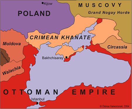
in 1502 they were organized as the independent Nogais north of the Caspian and those north of the Black Sea who were more or less subjects of the Crimean Khan.
The Cossacks The Slavs who lived on the frontier became known as Cossacks. By about 1500 they had formed two military polities: the Ukrainian Zaparozhian Sich on the Dnieper bend and the Russian Don Cossacks on the Don River bend. There is a good reason why these two communities were so far from the settled lands. Many of the Cossacks on the upper Don had recently left the settled lands and were still in reach of the Russian government. Most of those on the lower Don had been on the steppe for generations, knew no other way of life and were out of reach of the government. The same applies to the Zaporozhians in respect to Poland.
Russo-Crimean Wars
The Russo-Crimean Wars were fought between the forces of the Muscovy and the invading Tatars of the Crimean Khanate.-History:...
.
The Turks: This was a peripheral area for the great Ottoman Empire. The Turks had some control over Moldavia and Crimea, held a southern strip of the Crimean peninsula including the great slave port of Kaffa and held a fort at Azov. Turkish armies entered the steppe only twice during our period, although janissaries would sometimes accompany the Crimean Khan. The Turks were important because of their partial control of Crimea, their wars with Poland in the west, their implied threat to Russia if it moved too far south, and because they were the ultimate destination of slaves captured in Russia and Poland.
The Russians: In the early 15th century, 'Russia' was a group of minor principalities north of the Oka River which were gradually falling under the rule of Moscow. Its Orthodox religion allowed it to claim the heritage of Kievan Rus. Its autocracy gave it a fairly effective army. Russia also had a conflict between serfdom and frontier liberty, but its political consequences turned out to be less important. Also like Poland, Russia was frequently distracted by unprofitable wars in the west. Brian L. Davis suggests that Moscow's ultimate advantage was the comparative absence of restraints on its ability to command resources for war.
A Raiding Economy: In addition the wars recorded in history books, there was a massive amount of petty raiding which kept much of the area depopulated. Raiding and tribute were a major source of goods that could not be produced on the steppe. Crimeans and Nogais raided Russia and Poland. Crimean nobles launched private raids without regard to the Khan. Nogai and Kalmuck clans raided each other. Cossacks raided Crimeans and Nogais, rebelled against Poland and Russia and hired out for various private and public wars. The Bashkirs were also involved. Capture by Tatar raiders was a constant threat. The market at Kaffa, with its cheap water transport to areas of demand increased the value of captives. Some were ransomed back to Russia and some were sold east as far as Bukhara. By one estimate some 150,000 to 200,000 captives were taken from Russia in 1600–1650, but of course there are no exact figures. The numbers for Poland would be comparable.
Forest and Steppe: There was no clear line between steppe and forest, but rather a broad transition zone of forest-steppe. Zones ran from southwest to northeast. The steppe proper began as a narrow band near the Danube. In the east there were patches of grassland almost as far north as Kazan. Fingers of forest extended south down the river valleys. Slavic settlers preferred the river valleys because of better protection, transportation, firewood, game and soil (steppe grass can be quite difficult to plow).
1450–1550
The Breakup of the Golden Horde: As the Golden HordeGolden Horde
The Golden Horde was a Mongol and later Turkicized khanate that formed the north-western sector of the Mongol Empire...
weakened, the more settled areas broke off as follows: 1438: Khanate of Kazan
Khanate of Kazan
The Khanate of Kazan was a medieval Tatar state which occupied the territory of former Volga Bulgaria between 1438 and 1552. Its khans were the patrilineal descendants of Toqa Temür, the thirteenth son of Jochi and grandson of Genghis Khan. The khanate covered contemporary Tatarstan, Mari El,...
on the upper Volga, 1441: Khanate of Crimea on the Black Sea, 1452:Qasim Khanate
Qasim Khanate
Qasim Khanate or Kingdom of Qasim was a Tatar territorial formation , vassal of Russia, which existed from 1452 till 1681 in the territory of modern Ryazan Oblast in Russia with its capital Kasimov, in the middle stream of the Oka River...
on the Oka (a Russian vassal – the beginning of Russian rule over Turkic Muslims),1466: Astrakhan Khanate
Astrakhan Khanate
The Khanate of Astrakhan was a Tatar feudal state that appeared after the collapse of the Golden Horde. The Khanate existed in the 15th and 16th centuries in the area adjacent to the mouth of the Volga river, where the contemporary city of Astrakhan/Hajji Tarkhan is now located...
on the lower Volga. The steppe remnant became known as the Great Horde
Great Horde
- Dissolution of the Golden Horde :The peripheral regions of the Golden Horde broke off as follows: 1438: Kazan Khanate, 1441: Crimean Khanate, 1466: Astrakhan Khanate The remnant, which became known as the Great Horde, was left with the steppe between the Dnieper and Yaik, the capital Sarai and a...
. From 1480 to 1519 Russia and Crimea were allied against the Great Horde and Poland-Lithuania. In 1480 the Great Horde failed in an attempt to invade Muscovy (Great stand on the Ugra river), a date that is conventionally taken as the end of Tatar rule over Russia. The last Khan of the Great Horde was killed by the Crimeans in 1502. The steppe peoples then became known as the Nogai Horde
Nogai Horde
The Nogai Horde was a confederation of about eighteen Turkic and Mongol tribes that occupied the Pontic-Caspian steppe from about 1500 until they were pushed west by the Kalmyks and south by the Russians in the 17th century. The Mongol tribe called the Manghits constituted a core of the Horde...
. The Nogais on the Volga had their own Beg, while those north of the Black Sea were nominally subject to the Crimean Khan. The removal of the Great Horde as a buffer state brought Russia and Crimea into direct confrontation.
Consolidation North of the Oka By 1450 the Grand Duchy of Moscow
Grand Duchy of Moscow
The Grand Duchy of Moscow or Grand Principality of Moscow, also known in English simply as Muscovy , was a late medieval Rus' principality centered on Moscow, and the predecessor state of the early modern Tsardom of Russia....
held most of the land north of the Oka, except for an enclave about 150 km north and west of Moscow. The enclave was annexed: Yaroslavl
Yaroslavl
Yaroslavl is a city and the administrative center of Yaroslavl Oblast, Russia, located northeast of Moscow. The historical part of the city, a World Heritage Site, is located at the confluence of the Volga and the Kotorosl Rivers. It is one of the Golden Ring cities, a group of historic cities...
(1463), Rostov
Rostov
Rostov is a town in Yaroslavl Oblast, Russia, one of the oldest in the country and a tourist center of the Golden Ring. It is located on the shores of Lake Nero, northeast of Moscow. Population:...
(1474), Tver
Tver
Tver is a city and the administrative center of Tver Oblast, Russia. Population: 403,726 ; 408,903 ;...
(1485). Novgorod (300n,300west) was taken in 1470–1480 and Pskov (250n,500w) in 1510. Ryazan
Ryazan
Ryazan is a city and the administrative center of Ryazan Oblast, Russia. It is located on the Oka River southeast of Moscow. Population: The strategic bomber base Dyagilevo is just west of the city, and the air base of Alexandrovo is to the southeast as is the Ryazan Turlatovo Airport...
(100s,124e) on the Oka fell in 1521. During the Russo-Lithuanian Wars (1492–1522), Moscow took the northeast part of Lithuania, including the Upper Oka Principalities
Upper Oka Principalities
The Upper Oka Principalities is a term traditionally applied in Russian historiography to about dozen tiny and ephemeral polities situated along the upper course of the Oka River at the turn of the 14th and 15th centuries...
, Smolensk
Smolensk
Smolensk is a city and the administrative center of Smolensk Oblast, Russia, located on the Dnieper River. Situated west-southwest of Moscow, this walled city was destroyed several times throughout its long history since it was on the invasion routes of both Napoleon and Hitler. Today, Smolensk...
(1514,120s,250w), Novgorod Seversky(1503,400s,400w) and Chernihiv
Chernihiv
Chernihiv or Chernigov is a historic city in northern Ukraine. It is the administrative center of the Chernihiv Oblast , as well as of the surrounding Chernihivskyi Raion within the oblast...
(1503,480s,300w).
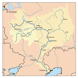
Thus by 1521 Moscow held all the forested land north of the Oka from its mouth at Nizhny Novgorod
Nizhny Novgorod
Nizhny Novgorod , colloquially shortened to Nizhny, is, with the population of 1,250,615, the fifth largest city in Russia, ranking after Moscow, St. Petersburg, Novosibirsk, and Yekaterinburg...
(50n,400e) to the Oka bend at Kaluga and west almost to the Gulf of Finland. In addition there was a bulge west of the Oka down to Chernigov.
Oka River
Oka is a river in central Russia, the largest right tributary of the Volga. It flows through the regions of Oryol, Tula, Kaluga, Moscow, Ryazan, Vladimir, and Nizhny Novgorod and is navigable over a large part of its total length, as far upstream as to the town of Kaluga. Its length exceeds...
. With the removal of the Great Horde as a buffer state, Crimea became the main enemy and work was begun to strengthen the Oka defenses. By 1533 about 250 km of the bank was extensively fortified, mainly from Kaluga
Kaluga
Kaluga is a city and the administrative center of Kaluga Oblast, Russia, located on the Oka River southwest of Moscow. Population: It is served by Grabtsevo Airport.-History:...
(150s,75w) on the Oka bend to Kolomna
Kolomna
Kolomna is an ancient city and the administrative center of Kolomensky District of Moscow Oblast, Russia, situated at the confluence of the Moskva and Oka Rivers, southeast of Moscow. The area of the city is about . The city was founded in 1177...
(65s,75e). There were weaker fortifications in the west along the Ugra River
Ugra River
thumb|250px|A picture of the river.Ugra is a river in Smolensk and Kaluga Oblasts in Russia, left tributary of the Oka River. The east-flowing Ugra joins the north-flowing Oka at Kaluga and the united river, called the Oka, continues east to the Volga. In the 16th century, the Ugra-Oka juncture...
and east down the Oka to Nizhny Novgorod(400e,75n). In addition there was an 'out-fort' at Tula
Tula, Russia
Tula is an industrial city and the administrative center of Tula Oblast, Russia. It is located south of Moscow, on the Upa River. Population: -History:...
(193s) along the main invasion route. From 1522 the military headquarters was at Kolomna. The bank was manned during the spring-to-fall raiding season. Troops were mostly horse archers drawn from the land-owning class, with increasing numbers of artillery and musketeers.
The Abatis Line or Zasechnaya cherta: After 1533 work began on the Abatis Line. From the 1550s troops began mustering on the emerging Abatis Line. This was about 100 km south of the Oka, in two sections. The first ran from the north-flowing part of the Oka south of Kaluga from Peremyshl
Peremyshl
Peremyshl may refer to:*Peremyshl, Russia, a village in Kaluga Oblast, Russia*Peremyshl, a Cyrillic alphabet transliteration of the city of Przemyśl...
(160s,75w) or Belyov
Belyov
Belyov is a town and the administrative center of Belyovsky District of Tula Oblast, Russia, located on the left bank of the Oka River. Population: 17,000 .As many other Upper Oka towns, Belyov was first mentioned in a chronicle in 1147...
(225s,75w) roughly along the Upa River
Upa River
Upa is a river in Tula Oblast, Russia, one of the main tributaries of the Oka River.The river is 345 km long; the city of Tula is on its banks. The name of the river is of Baltic origin....
to Odoyev (200s,50w), Krapivna
Krapivna
Krapivna or Kropivna is a large village on the Upa River in Shchyokino Raion of Tula Oblast, Russia. It was first documented in the testament of the Russian monarch Dmitry Donskoy and remained the center of an uyezd until the October Revolution...
(200s,25w), the great fort of Tula
Tula, Russia
Tula is an industrial city and the administrative center of Tula Oblast, Russia. It is located south of Moscow, on the Upa River. Population: -History:...
(193s), and then past Venyov
Venyov
Venyov is a town and the administrative center of Venyovsky District of Tula Oblast, Russia, located on the Venyovka River, east of Tula. Population:...
(150s,33e) to the Oka at Ryazan
Ryazan
Ryazan is a city and the administrative center of Ryazan Oblast, Russia. It is located on the Oka River southeast of Moscow. Population: The strategic bomber base Dyagilevo is just west of the city, and the air base of Alexandrovo is to the southeast as is the Ryazan Turlatovo Airport...
(125s,125e). The second started southwest of Ryazan and ran from Skopin
Skopin
Skopin is a town in Ryazan Oblast, Russia, located on the Vyorda River southwest of Ryazan. Population: Skopin is considered to be one of the oldest towns in Ryazan Oblast. A settlement named Likharevskoye Gorodishche near present-day Skopin was founded some time in the 12th century...
(founded 1597,200s,100e) through Ryazhsk
Ryazhsk
Ryazhsk is town and the administrative center of Ryazhsky District of Ryazan Oblast, Russia, located south of Ryazan. Population: 26,000 ....
(1502,233s,150e) and Sapozhok(200s,200e) to Shatsk
Shatsk
Shatsk may refer to:*Shatsk, Russia, a town in Ryazan Oblast, Russia*Shatsk, Ukraine, an urban-type settlement in Volyn Oblast, Ukraine...
(1552,200s,250e). The Abatis Line underwent a major reconstruction in 1638 and again in 1659–60. (Note that this account of the course of the Line may not be exact since Davies (see references), who seems to be the only good source, appears to contradict himself in a few places.)
From the 1550s there was a line of sorts from Shatsk to Alatyr
Alatyr (town)
Alatyr is a town in the Chuvash Republic, Russia, located on the Sura River at its confluence with the Alatyr River. Population: 43,161 ; 43,000 ....
(1552,150s,550e).
1550–1618: Down the Volga
Russo-Kazan Wars
thumb|300px|[[St. Basil's Cathedral]] is a monument to the Russian conquest of Kazan in 1552.The Russo-Kazan Wars was a series of wars fought between the Khanate of Kazan and Muscovite Russia from 1438, until Kazan was finally captured by Ivan the Terrible and absorbed into Russia in 1552.- Wars of...
, usually involving Moscow and Crimea backing various claimants for the Kazan throne, but Kazan(700e,25s) was too far away to be dealt with easily. Advanced forts were built at Vasilsursk
Vasilsursk
Vasilsursk is an urban locality in Vorotynsky District of Nizhny Novgorod Oblast, Russia, located on the Sura River, not far from its fall into the Volga. Population:...
on the Volga below Nizhny Novgorod(1523:533e) and Sviyazhsk
Sviyazhsk
Sviyazhsk or Zöyä is a rural locality in the Republic of Tatarstan, Russia, located at the confluence of the Volga and Sviyaga Rivers...
(1551:675e,25s) near Kazan. Kazan was conquered in 1552. In 1554 Moscow installed a Nogai prince on the thrown of Astrakhan
Astrakhan Khanate
The Khanate of Astrakhan was a Tatar feudal state that appeared after the collapse of the Golden Horde. The Khanate existed in the 15th and 16th centuries in the area adjacent to the mouth of the Volga river, where the contemporary city of Astrakhan/Hajji Tarkhan is now located...
. When he rebelled, Russia annexed Astrakhan(1556:700e,1000s). (This enormous expansion to the southeast presumably depended on river transport down the Volga, but this is not clear from the English sources.) In the First Russo-Turkish War (1568–1570)
Russo-Turkish War (1568–1570)
The Russo–Turkish War is a war between the Tsardom of Russia and the Ottoman Empire. The casus belli was the Astrakhan Khanate....
, the Ottomans tried and failed to retake Astrakhan for Islam. Following the Livonian War, intermediate forts were built on the Volga: Samara(1586:300s,800e), Saratov(1590:450s,500e), Tsaritsyn (=Stalingrad)(1589:800s,400e). Between the Volga and Urals Ufa
Ufa
-Demographics:Nationally, dominated by Russian , Bashkirs and Tatars . In addition, numerous are Ukrainians , Chuvash , Mari , Belarusians , Mordovians , Armenian , Germans , Jews , Azeris .-Government and administration:Local...
(350s,1100e)was founded in 1574.
The Nogai Horde
Nogai Horde
The Nogai Horde was a confederation of about eighteen Turkic and Mongol tribes that occupied the Pontic-Caspian steppe from about 1500 until they were pushed west by the Kalmyks and south by the Russians in the 17th century. The Mongol tribe called the Manghits constituted a core of the Horde...
: The independent Nogais on the lower Volga were happy to support whatever regional power suited their immediate interests. Moscow managed them with a mixture of bribes and threats. From the 1530s, some Nogais would ally with Russia, apparently finding more profit in trading than raiding (In 1555 Ismail sent 20,000 horses to Moscow.). Nogai help or indifference was an important factor in the conquest of Kazan. Ismail assisted Russia in the first Astrakhan campaign. This provoked the hostility of Yosuf on the Yaik. Friends of Ismael murdered Yosuf in 1555 and Ismail declared himself Beg of all the Nogais. Yosuf's sons went after him and reduced him to near poverty. This mutual raiding was made worse by a famine. In 1557 Kazy Mirza broke off and established the Lesser Nogai Horde on the Kuban as a Crimean vassal. In 1600 Russia 'appointed' a Nogai Beg for the first time. The Begship disappears from the English sources in 1618. Around 1630 the Kalmyks migrated from Dzungaria and took over most of the Nogai lands on the lower Volga. The remaining Nogais were then nominally Crimean vassals, either north of the Black Sea, or in the Small Nogai Horde on the Kuban.
To Siberia: There was a slow and steady expansion into the Perm-Kama lands to the northeast, which seems poorly document. In 1582 the Urals were crossed and the conquest of Siberia began. See Siberian River Routes
Siberian River Routes
Siberian River Routes were the main ways of communication in the Russian Siberia before the 1730s, when roads began to be built. The rivers also were of primary importance in the process of Russian exploration and colonisation of vast Siberian territories...
, History of Siberia
History of Siberia
The early history of Siberia is greatly influenced by the sophisticated nomadic civilizations of the Scythians and Xiongnu , both flourishing before the Christian era. The steppes of South Siberia saw a succession of nomadic empires, including the Turkic Empire and the Mongol Empire...
.
1550–1618: Center
The Livonian War and Time of Troubles: Instead of consolidating his gains in the southeast, Ivan turned west (Livonian WarLivonian War
The Livonian War was fought for control of Old Livonia in the territory of present-day Estonia and Latvia when the Tsardom of Russia faced a varying coalition of Denmark–Norway, the Kingdom of Sweden, the Union of the Grand Duchy of Lithuania and the Kingdom of Poland.During the period 1558–1578,...
1558–1583). After some initial successes the war degenerated into a free-for-all among all the Baltic powers. At war's end Russia returned, exhausted, to its original frontiers. The strain of this war, Ivan's erratic behavior and other factors led to the Time of Troubles
Time of Troubles
The Time of Troubles was a period of Russian history comprising the years of interregnum between the death of the last Russian Tsar of the Rurik Dynasty, Feodor Ivanovich, in 1598, and the establishment of the Romanov Dynasty in 1613. In 1601-1603, Russia suffered a famine that killed one-third...
(1598–1613). This confusion led to a fair number of people to flee south of the Oka, but, as usual, we have no numbers.
Crimea: In 1556 Moscow, in alliance with Dmytro Vyshnevetsky
Dmytro Vyshnevetsky
Dmytro Ivanovych Vyshnevetsky was a Hetman of the Ukrainian Cossacks. He was also known as Baida in the Ukrainian folk songs.-Biography:...
of the Zaporozhian Cossacks attempted several raids on the Black Sea coast. This policy was abandoned after the start of the Livonian war. In 1571, while troops were away in Livonia, Crimea broke through the Oka Line and burned Moscow (Russo-Crimean War (1571)). This led to a strengthening of southern defenses which blocked the next raid (Battle of Molodi
Battle of Molodi
The Battle of Molodi was one of the key battles of Ivan the Terrible's reign. It was fought near the village of Molodi, 40 mi south of Moscow, in July-August 1572 between the 120,000-strong horde of Devlet I Giray of Crimea and about 60,000 Russians led by Prince Mikhail Vorotynsky...
).
South of the Abatis Line:With the end of the Livonian War in 1583 attention could be turned to the east and south. New forts were built along and east of Volga (Samara, Saratov and Tsaritsyn and Ufa). The conquest of Siberia began in 1582. To the south, forts were built along the main Tatar raiding trail at Elets(1592:350s,50e)) , Voronezh
Voronezh
Voronezh is a city in southwestern Russia, the administrative center of Voronezh Oblast. It is located on both sides of the Voronezh River, away from where it flows into the Don. It is an operating center of the Southeastern Railway , as well as the center of the Don Highway...
(1586:450s,100e), Belgorod
Belgorod
-Twin towns/sister cities:Belgorod is twinned with: Wakefield, England, United Kingdom Herne, North Rhine-Westphalia, Germany Palembang, South Sumatra, Indonesia Opole, Poland Vyshhorod, Ukraine Kharkiv, Ukraine-External links:...
(1593:575s,75w) and Stary Oskol
Stary Oskol
Stary Oskol is a city in Belgorod Oblast, Russia, located south of Moscow, on the Oskol River. Population: 221,163 ; 215,898 ; -History:...
(1593:490s). These were used as refuges for peasants and livestock during Tatar raids. Sorties from these forts could sometimes deal with smaller war parties and rescue captives. In the far south, Tsarev Borisov(750s) was founded in 1599 and abandoned after 1618.
Colonization: Peasants in the settled lands were generally serfs who could not legally leave their lords, but, given the weakness of police and record-keeping at this time, once a peasant ran away, it was quite difficult to find him and bring him back. Frontier landowners and garrison commanders who needed peasants would often protect any runaways that showed up. Runaways blended into the general class of adventurers, drifters, discharged soldiers and other unclassifables who lived along the frontier. Many peasants went only a short way south and remained connected to the economic and political system of the settled lands, while a few went further south into the truly wild lands and became full Cossacks. Moscow vacillated between protecting the interests of its landowners and encouraging frontier settlement. Growing military presence in the south reduced the Tatar threat and increased the number of peasants who were willing to try their luck on the frontier. A proper history of Russia's southward expansion would need a table showing population by region and decade, but such numbers do not seem to be available.
1618–1686: The Belgorod Line
Time of Troubles and Reconstruction: During the Time of Troubles (1598–1613) Moscow lost control of much of the southern area. Various towns were sacked by the Poles, Tatars and Zaporozhian Cossacks. The Truce of DeulinoTruce of Deulino
Truce of Deulino was signed on 11 December 1618 and took effect on 4 January 1619. It concluded the Polish–Muscovite War between the Polish–Lithuanian Commonwealth and the Tsardom of Russia....
ended the Russo-Polish War (1605-1618) and Russia lost Smolensk, Seversk and Chernigov. During the period of reconstruction (1618–33) the south continued to be neglected. The only significant new fort was Lebedyan
Lebedyan
Lebedyan is a town and the administrative center of Lebedyansky District of Lipetsk Oblast, Russia, located on the upper Don River northwest of Lipetsk. It is the location of the largest fruit juice manufacturer in Eastern Europe, Lebedyansky. Population: Lebedyan was founded in 1613 largely to...
.
Smolensk War
Smolensk War
The Smolensk War was a conflict fought between the Polish-Lithuanian Commonwealth and Russia.Hostilities began in October 1632 when Tsar forces tried to recapture the city of Smolensk, a former Russian possession. Small military engagements produced mixed results for both sides, but the surrender...
(1632–34): During this war Russia tried and failed to retake Smolensk. Westward diversion of troops led to two major Crimean raids. The one in 1633 was apparently the last to cross the Oka. The war also saw the first use of foreign- formation troops (European mercenary officers and paid soldiers using Dutch-style drill) that were to be important for the next 75 years. At the start of the war Russia could field about 100,000 men: 27,000 traditional servicemen, 33,000 musketeers, 4,000 artillerymen, 11,000 Cossacks, and about 20,000 Tatar irregulars (up from 35,000 in 1500).
Belgorod Line: With the end of the Smolensk War in 1634 and the Tatar raid of 1633, Moscow turned its attention south. Frontier troops were more than tripled to 17,500. In 1638 there was a major rebuilding of the Abatis Line. Forts south of the Abatis Line were linked up. Eleven new garrison towns were founded in 1635–37. Tatar raids in 1644 showed that fortification was incomplete and eighteen new forts were founded by 1653. From 1646 frontier deployment was moved south to the Belgorod line. From 1650 command was centered at Belgorod. To attract settlers standards were relaxed, many people being granted lands as 'odnodvortsy' (roughly yeomen).
The completed Belgorod Line was shaped like a reversed 'L'. It ran south down the Voronezh River
Voronezh River
Voronezh is a river in Tambov, Lipetsk, and Voronezh Oblasts in Russia, a left tributary of the Don. The Voronezh River is 342 km in length. The area of its drainage basin is 21,600 km². It freezes up in the first half of December and stays under the ice until late March. The lower...
from Kozlov
Michurinsk
Michurinsk , before 1932—Kozlov , is the second most populous town in Tambov Oblast, Russia. Population: It was founded in 1635 at the northern end of the emerging Belgorod Line. A 25-km earthen wall was built eastward across the open steppe effectively blocking the Nogai Trail, a Tatar raiding...
(1635,325s,175e) through Dobryi, Usman
Usman (town)
Usman is a town and the administrative center of Usmansky District of Lipetsk Oblast, Russia, located on the Usman River, south of Lipetsk. Population:...
(1645), Orlov, Voronezh
Voronezh
Voronezh is a city in southwestern Russia, the administrative center of Voronezh Oblast. It is located on both sides of the Voronezh River, away from where it flows into the Don. It is an operating center of the Southeastern Railway , as well as the center of the Don Highway...
(1585,450s,100e) and continued down the Don. Where the Don turns east(about 500s) it ran southwest to Ostrogozhsk
Ostrogozhsk
Ostrogozhsk is a town and the administrative center of Ostrogozhsky District in Voronezh Oblast, Russia, located on the Tikhaya Sosna River south of Voronezh. Population: It was established in 1652 and granted town status in 1765....
(1652,525s,75e) then west and slightly south through Userdsk(1637), Novy Oskol
Novy Oskol
Novy Oskol is a town in Belgorod Oblast, Russia, located on the Oskol River, northeast of Belgorod. Population: -External links:*...
(550s,) Ioblonov, Korocha
Korocha
Korocha is a town and the administrative center of Korochansky District of Belgorod Oblast, Russia, located on the right bank of the Korocha River , northeast of Belgorod. Population: Korocha was founded in 1638...
(1638), Belgorod
Belgorod
-Twin towns/sister cities:Belgorod is twinned with: Wakefield, England, United Kingdom Herne, North Rhine-Westphalia, Germany Palembang, South Sumatra, Indonesia Opole, Poland Vyshhorod, Ukraine Kharkiv, Ukraine-External links:...
(1596,575s,50w), Kotmyzsk to Okhtyrka
Okhtyrka
Okhtyrka is a city in Ukraine, a raion centre within Sumy Oblast. It is situated near the Vorskla River, on an eleven-mile spur of the Kiev–Kharkiv railway line. It is home to Akhtyrka air base...
(1641, a Polish foundation:600s,150w). Okhtyrka is about 300 km east of Kiev and 200 km north of the Dnieper bend. The lower Belgorod Line was about 400 km south of the Abatis Line and just north of the Dnieper country then claimed by Poland.
The Don and Voronezh Rivers run down the eastern side, the Donets penetrates at Belgorod and, in the west, the Vorskla River flows south from Okhtyrka through Poltava to the Dnieper. The Belgorod Line encloses a rectangle of about 400 by 300 kilometers. This area contains the central part of the Muravsky Trail
Muravsky Trail
Muravsky Trail or Murava Route was an important trade route and according to the Russian historiography a favourite invasion route of the Crimean Tatars during the Russo-Crimean Wars of the 16th and early 17th centuries. It was also used somewhat for peaceful trade...
Tatar raiding trail and corresponds approximately to the Central Black Earth Region
Central Black Earth Region
Central Black Earth Region or Central Chernozem Region is a segment of the Eurasian chernozem belt that lies within Central Russia and comprises Voronezh Oblast, Lipetsk Oblast, Belgorod Oblast, Tambov Oblast, Oryol Oblast and Kursk Oblast...
. Inside the rectangle are Lebedyan
Lebedyan
Lebedyan is a town and the administrative center of Lebedyansky District of Lipetsk Oblast, Russia, located on the upper Don River northwest of Lipetsk. It is the location of the largest fruit juice manufacturer in Eastern Europe, Lebedyansky. Population: Lebedyan was founded in 1613 largely to...
(1591), Elets(1633), Livny
Livny
Livny is a town in Oryol Oblast, Russia. Population: The town apparently originated in 1586 as Ust-Livny, a wooden fort on the bank of the Livenka River, although some believe that a town had existed on the spot previous to the Mongol invasion of Rus...
(c1586), Oryol
Oryol
Oryol or Orel is a city and the administrative center of Oryol Oblast, Russia, located on the Oka River, approximately south-southwest of Moscow...
(1566) and Kursk
Kursk
Kursk is a city and the administrative center of Kursk Oblast, Russia, located at the confluence of the Kur, Tuskar, and Seym Rivers. The area around Kursk was site of a turning point in the Russian-German struggle during World War II and the site of the largest tank battle in history...
. To the west was Severia
Severia
Severia or Siveria is a historical region in present-day northern Ukraine and southwestern Russia, centered around the city of Novhorod-Siverskyi in Ukraine.-Severians:...
and Polish territory. Population inside the line must have grown, but there seem to be no figures.
East of the Belgorod Line: The sources do not explain why the Belgorod line did not run east-west. Its shape left an area of about 450 km between the Belgorod Line and the Volga forts and about 600 km from the eastern end of the Abatis Line to the Don Cossacks in the south. This area had a fair amount of open steppe and corresponded roughly to the 'Nogai Road', the raiding trail from the lower Volga. Apart from the northern fortifications, the English secondary sources have little information about this area.
The northern part of this area was fortified at the same time as the Belgorod Line. In 1636 a wall was built east from Kozlov at the north end of the Belgorod Line that effectively blocked the Nogai Road. It was later extended to Tambov(1636:333s,333e). In 1647 work started on a line from Tambov north up the Tsna to Shatsk at the eastern end of the Abatis Line. In 1648–54, the Simbirsk Line was built , which ran from Tambov
Tambov
Tambov is a city and the administrative center of Tambov Oblast, Russia, located at the confluence of the Tsna and Studenets Rivers southeast of Moscow...
(1636) through Nizhny Lomov
Nizhny Lomov
Nizhny Lomov is a town and the administrative center of Nizhnelomovsky District of Penza Oblast, Russia, located on the Lomov River , northwest of Penza and from Moscow on the M5 Highway. Population:...
(1636) and Saransk
Saransk
Saransk is a city in central European Russia and the capital of the Republic of Mordovia, as well as its financial and economic center. It is located in the Volga basin at the confluence of the Saranka and Insar Rivers, about east of Moscow...
(1641) to Simbirsk (1648, 200s,790e) on the Volga. Part of the Simbirsk Line was later replaced by the Syzran Line which ran from a point east of Nizhny Lomov to the Volga south of Simbirsk. The Trans-Kama Line (1652–57) ran eastward from the Volga at Bely Yar below Simbirsk to Menzelinsk
Menzelinsk
Menzelinsk , also spelled Minzala or Minzele, is a town in the Republic of Tatarstan, Russia, located on the Menzelya River , east of Kazan. Population: 15,800 . Russians account for 49.3% of the town's population, while Tatars comprise 46.8%.It was founded in 1584–1586 and was granted status of...
(1586 975e) on a southern tributary of the Kama. Thus Moscow had about 1800 km of fortified line stretching from Polish territory almost to the Urals.
The Stenka Razin
Stenka Razin
Stepan Timofeyevich Razin Тимофеевич Разин, ; 1630 – ) was a Cossack leader who led a major uprising against the nobility and Tsar's bureaucracy in South Russia.-Early life:...
rebellion was mostly confined to the area east of the Belgorod Line and south of Simbirsk.
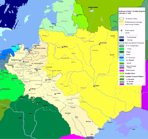
1648–1709: Ukraine
Polish-Lithuanian Background: By about 1362(Battle of Blue WatersBattle of Blue Waters
The Battle of Blue Waters was a medieval battle fought at some time between 24 September and 25 December 1362 near the Syni Vody of the Southern Bug between the armies of the Grand Duchy of Lithuania and the Golden Horde....
) most of the northwest Ukraine (including Kiev) had fallen to Lithuania. In 1385 (Union of Krewo
Union of Krewo
In a strict sense, the Union of Krewo or Act of Krėva was a set of prenuptial promises made in the Kreva Castle on 14 August 1385 by Jogaila, Grand Duke of Lithuania, in exchange for marriage to the underage reigning Queen Jadwiga of Poland...
) the crowns of Poland and Lithuania were joined and Lithuania became Christian, the last European country to do so. In 1569(Union of Lublin
Union of Lublin
The Union of Lublin replaced the personal union of the Kingdom of Poland and the Grand Duchy of Lithuania with a real union and an elective monarchy, since Sigismund II Augustus, the last of the Jagiellons, remained childless after three marriages. In addition, the autonomy of Royal Prussia was...
), during the Livonian War, a closer union was made and most of Ukraine was transferred from Lithuania to Poland. In 1596(Union of Brest
Union of Brest
Union of Brest or Union of Brześć refers to the 1595-1596 decision of the Church of Rus', the "Metropolia of Kiev-Halych and all Rus'", to break relations with the Patriarch of Constantinople and place themselves under the Pope of Rome. At the time, this church included most Ukrainians and...
) an attempt was made at church union. The Orthodox would retain their rites and married clergy while accepting the doctrinal supremacy of the Pope. Since some Orthodox rejected this, the effect was to create three churches instead of two. From about 1610 the Orthodox and Zaporozhian Cossacks became more closely allied, thereby increasing the alienation of both from Poland. From about 1637 there were rebellions in the eastern lands which led to a movement of population into Russian territory south of the Belgorod Line (Sloboda Ukraine
Sloboda Ukraine
Sloboda Ukraine was a historical region which developed and flourished in the 17th and 18th centuries on the southwestern frontier of the Tsardom of Russia....
).
Khmelnytsky: In 1648 Bohdan Khmelnytsky
Bohdan Khmelnytsky
Bohdan Zynoviy Mykhailovych Khmelnytsky was a hetman of the Zaporozhian Cossack Hetmanate of Polish–Lithuanian Commonwealth . He led an uprising against the Commonwealth and its magnates which resulted in the creation of a Cossack state...
started a rebellion which quickly became a general Orthodox rising against Poland, extending as far west as Volhynia. It also became something of a social revolution as landowners, Poles, Catholics and Jews were driven west. Khmelnytsky sought Russian support, but Russia hesitated, knowing that this would lead to a major war with Poland. In 1654 Russia accepted Khmelnitsky as a vassal(Treaty of Pereyaslav
Treaty of Pereyaslav
The Treaty of Pereyaslav is known in history more as the Council of Pereiaslav.Council of Pereyalslav was a meeting between the representative of the Russian Tsar, Prince Vasili Baturlin who presented a royal decree, and Bohdan Khmelnytsky as the leader of Cossack Hetmanate. During the council...
).
Russo-Polish War (1654–1667)
Russo-Polish War (1654–1667)
The Russo-Polish War of 1654–1667, also called Thirteen Years' War, First Northern War, War for Ukraine was the last major conflict between Tsardom of Russia and the Polish-Lithuanian Commonwealth. Between 1655 and 1660, the Second Northern War was also fought in the Polish-Lithuanian Commonwealth,...
: Russia struck first, taking Smolensk. In 1665 Sweden attacked Poland leading to the near collapse of the Commonwealth (the so-called 'Deluge'). Instead of finishing off Poland, Russia and Sweden fell out (Russo-Swedish War (1656–1658)), giving the Commonwealth time to recover. By the Treaty of Andrusovo
Treaty of Andrusovo
The Truce of Andrusovo was a thirteen and a half year truce, signed in 1667 between Tsardom of Russia and the Polish-Lithuanian Commonwealth, which were at war since 1654 over the territories of modern-day Ukraine and Belarus....
in 1667, Russia acquired Smolensk and Chernigov and nominal rule over the lands east of the Dnieper, including Kiev. To the south of this, Zaporozhia was in theory a Russo-Polish condominium, but in practice continued under Cossack self-government. By the Eternal Peace Treaty of 1686
Eternal Peace Treaty of 1686
The Eternal Peace Treaty of 1686 was a treaty between Tsardom of Russia and Polish-Lithuanian Commonwealth, signed by Polish-Lithuanian Commonwealth envoys: voivod of Poznań Krzysztof Grzymułtowski and chancellor of Lithuania Marcjan Ogiński and Russian knyaz Vasily Vasilyevich...
Poland gave up its claim to Zaporozhia.
The Ruin: After Khmelnytsky's death in 1657 it proved impossible to maintain a Cossack state. The area was effectively divided at the Dnieper from 1660. The partition of Andrusovo was done without Cossack consent. See The Ruin (Ukrainian history)
The Ruin (Ukrainian history)
The Ruin is a period of Ukrainian history from the death of hetman Bohdan Khmelnitsky in 1657 and until ascension of hetman Ivan Mazepa in 1687. This period is characterised by continuous strife, civil war, and foreign intervention of Ukraine's neighbours...
. During this period, Doroshenko allied with the Turks, bringing Ottoman armies onto the steppe for the second and last time (Russo-Turkish War (1676–1681).
Ukraine Partitioned: After 1667 eastern Ukraine was divided into four areas. The Right Bank of the Dnieper gradually returned to Polish control. On the Left Bank was the Cossack Hetmanate
Cossack Hetmanate
The Hetmanate or Zaporizhian Host was the Ruthenian Cossack state in the Central Ukraine between 1649 and 1782.The Hetmanate was founded by first Ukrainian hetman Bohdan Khmelnytsky during the Khmelnytsky Uprising . In 1654 it pledged its allegiance to Muscovy during the Council of Pereyaslav,...
under Russian suzerainty. Over the next hundred years it was slowly converted into a group of normal Russian provinces. To the east of this and south of the Belgorod Line was the Sloboda Ukraine
Sloboda Ukraine
Sloboda Ukraine was a historical region which developed and flourished in the 17th and 18th centuries on the southwestern frontier of the Tsardom of Russia....
. This area, newly settled by immigrants from further west, retained a Cossack way of life, but Russia never permitted a Cossack political organization. South of the Hetmanate on the Dnieper bend, Zaporozhia was nominally subject to the Hetmanate, but was practically self-governing. Over the next century these areas shared the fate of the Hetmanate.
The Izium Line: From 1680 a triangular area south of the Belgorod Line in the Sloboda Ukraine
Sloboda Ukraine
Sloboda Ukraine was a historical region which developed and flourished in the 17th and 18th centuries on the southwestern frontier of the Tsardom of Russia....
was fortified. The new line was 530 kilometers long and enclosed 30,000 square km. It pushed the frontier another 160 km southward to within 150 km of the Black Sea coast. From Userdsk west of the southeast corner of the Belgorod Line, it ran southwest to Valuyki
Valuyki
Valuyki is a town in Belgorod Oblast, Russia, situated at the confluence of the Valuy and Oskol Rivers, some east of Belgorod. Population: 35,322 ; 35,790 ; 34,863 ; 27,000 ....
(1593,625s,60s) and then south down the Oskol River
Oskol River
Oskol is a river in Russia and Ukraine. It is a left tributary of the Seversky Donets. It is 436 km long, with a drainage basin of 14,680 km²....
to its juncture with the Donets (750s) below the old site of Tsarev-Borisov which was apparently reestablished. It then turned northwest up the Donets past Izium
Izium
Izyum , is a city situated on the Donets River in the Kharkiv Oblast of eastern Ukraine. Serving as the administrative center of the Iziumsky Raion , the city itself is also designated as a separate raion within the oblast, and is located approximately 75 miles southeast of the oblast capital,...
, Zmiiv
Zmiiv
Zmiiv is a city in Kharkiv Oblast of Ukraine. The population as of 2001 was 17,063. Zmiiv is the administrative center of Zmiivskyi Raion...
and Valky
Valky
Valky is a city in Kharkiv Oblast of Ukraine. Population is 10,381 ....
to Kolomak(650s,150w) with an extension southwest down the Kolomak River to Poltava
Poltava
Poltava is a city in located on the Vorskla River in central Ukraine. It is the administrative center of the Poltava Oblast , as well as the surrounding Poltava Raion of the oblast. Poltava's estimated population is 298,652 ....
. Kolomak is about 60 km southwest of the west end of the Belgorod Line at Okhtyrka. The area inside the line corresponds approximately to Kharkiv Oblast
Kharkiv Oblast
Kharkiv Oblast is an oblast in eastern Ukraine. The oblast borders Russia to the north, Luhansk Oblast to the east, Donetsk Oblast to the south-east, Dnipropetrovsk Oblast to the south-west, Poltava Oblast to the west and Sumy Oblast to the north-west...
and contains the modern city of Kharkiv
Kharkiv
Kharkiv or Kharkov is the second-largest city in Ukraine.The city was founded in 1654 and was a major centre of Ukrainian culture in the Russian Empire. Kharkiv became the first city in Ukraine where the Ukrainian Soviet Socialist Republic was proclaimed in December 1917 and Soviet government was...
which began as a small fort about 1630.
1686–1783: To the Black Sea
The KalmucksKalmyk people
Kalmyk people is the name given to the Oirats, western Mongols in Russia, whose descendants migrated from Dzhungaria in 1607. Today they form a majority in the autonomous Republic of Kalmykia on the western shore of the Caspian Sea. Kalmykia is Europe's only Buddhist government...
: From about 1630 the Kalmucks (Buddhist Mongols) occupied the lower Volga. They were generally allied with the Russians against their Islamic neighbors and caused the Russians relatively less trouble than the Nogais. With increasing Russian pressure and settlement, in 1771, most of the Kalmucks east of the Volga returned to Dzungaria, leaving a remnant southeast of the Volga.
The Russo-Turkish War (1686–1700): After the Turkish failure to take Vienna in 1683, Russia joined Austria, Poland and Venice in the Holy League (1684)
Holy League (1684)
Holy League of 1684 was initiated in by Pope Innocent XI, and composed of the Holy Roman Empire, the Polish-Lithuanian Commonwealth and the Venetian Republic. Tsardom of Russia joined the League in 1686. This alliance opposed the Ottoman Empire in the Great Turkish War and lasted until the Treaty...
to drive the Turks southward. Russia and Poland signed the Eternal Peace Treaty of 1686
Eternal Peace Treaty of 1686
The Eternal Peace Treaty of 1686 was a treaty between Tsardom of Russia and Polish-Lithuanian Commonwealth, signed by Polish-Lithuanian Commonwealth envoys: voivod of Poznań Krzysztof Grzymułtowski and chancellor of Lithuania Marcjan Ogiński and Russian knyaz Vasily Vasilyevich...
. There were three campaigns north of the Black Sea.
Crimean Campaigns
Crimean campaigns
Crimean campaigns of 1687 and 1689 were two military campaigns of the Russian army against the Crimean Khanate. They were a part of the Russo-Turkish War and Russo-Crimean Wars. These were the first Russian forces to come close to Crimea since 1569...
of 1687 and 1689: Two attempts were made to reach Perekop and bottle up the Crimeans inside their peninsula. They failed because of the difficulty of moving large numbers of men and horses across the steppe.
The Lower Dnieper Forts (1695): From 1694 Peter the Great planned two campaigns using river transport. In 1695 the main Dnieper fort at Kazy-Kermen was taken when a Russian mine accidentally set off its power magazine. The lesser forts quickly surrendered, but Kazy-Kermen was too damaged to hold and the main Russian force withdrew up the Dnieper to protect the Left Bank. By the Treaty of Constantinople
Treaty of Constantinople
The Treaty of Constantinople may refer to:* Rus'–Byzantine Treaty signed in Constantinople* Rus'–Byzantine Treaty signed in Constantinople* Rus'–Byzantine Treaty signed in Constantinople...
(1700) the remaining Russian forces were withdrawn and the area south of Zaporozhia became a demilitarized zone.
Azov
Azov
-External links:** *...
: From 1471 the Turks had a fortress at Azov at the mouth of the Don. In 1637–42 it was captured and briefly held by the Don Cossacks. In 1695 Peter failed to take the fort because he could not control the river and prevent re-supply. In 1696 he build ships at Voronezh, sailed them down the Don and captured Azov. He built more ships at Taganrog which were bottled up in the Sea of Azov. After its defeat in the Russo-Turkish War (1710–1711) Russia gave up Azov and its fleet.
The Oleshky Cossacks (1711–1734): Following the battle of Poltava
Battle of Poltava
The Battle of Poltava on 27 June 1709 was the decisive victory of Peter I of Russia over the Swedish forces under Field Marshal Carl Gustav Rehnskiöld in one of the battles of the Great Northern War. It is widely believed to have been the beginning of Sweden's decline as a Great Power; the...
about 20,000 Cossack fled to Ottoman territory and established a Sich at Oleshky across the Dnieper from modern Kherson
Kherson
Kherson is a city in southern Ukraine. It is the administrative center of the Kherson Oblast , and is designated as its own separate raion within the oblast. Kherson is an important port on the Black Sea and Dnieper River, and the home of a major ship-building industry...
. Although Turkish subjects, they represented a further southward expansion. By the agreement of Lubni(1744) they returned to Russia and established the New Sich. Oleshky is 100 km northwest of Perekop.
Russo-Turkish War (1735–1739): in 1736 the Russians stormed Perekop and captured Bakhchisarai but withdrew because of plague. In the same year they took Azov. In 1737 they took Ochakov but gave it up because of plague. By the Treaty of Nissa
Treaty of Nissa
The Treaty of Niš is a peace treaty signed on September 29, 1739 in Niš , by the Ottoman Empire on one side and Russian Empire on the other. The Russo-Turkish War, 1735-1739 was the result of the Russian effort to gain Azov and Crimea as a first step towards dominating the Black Sea...
Russia was allowed to have a port, but no fort, at Azov.
Russo-Turkish War (1768–1774): Russia sent its Baltic fleet into the Mediterranean and defeated the Turkish fleet. The war ended with the Treaty of Kuchuk-Kainarji. Russia was allowed to use Azov for military purposes. It gained control of the Kerch Strait leading from the Sea of Azov to the Black Sea. It gained Yedisan
Yedisan
Yedisan is a historical region in modern southwestern Ukraine and southeastern Moldova . The region lies to the north of the Black Sea between the Dniester and Dnieper rivers...
between the Dnieper and the Bug, including the new port of Kherson
Kherson
Kherson is a city in southern Ukraine. It is the administrative center of the Kherson Oblast , and is designated as its own separate raion within the oblast. Kherson is an important port on the Black Sea and Dnieper River, and the home of a major ship-building industry...
(1778). Crimea was to be independent of the Turks, but in fact became a Russian vassal.
Crimea Annexed: Russia installed Şahin Giray
Sahin Giray
Şahin Giray was the last Khan of Crimea. He was born in 1745 in Edirne.He studied in Greece and also in Venice.He reputedly spoke the Crimean Tatar language as well as Ottoman Turkish, Italian and Greek....
as Khan. His overly firm rule provoked rebellion and he had to be propped up by Russian troops. Crimea was finally annexed in 1783.
Later: Russian expansion to the area north of the Caucasus is not covered in this article. In 1792 the Russian frontier reached the Dniester (Russo-Turkish War (1787–1792). In 1793 the Ukrainian Right Bank was annexed by the Second Partition of Poland
Second Partition of Poland
The 1793 Second Partition of the Polish-Lithuanian Commonwealth was the second of three partitions that ended the existence of the Polish-Lithuanian Commonwealth by 1795. The second partition occurred in the aftermath of the War in Defense of the Constitution and the Targowica Confederation of 1792...
. In 1812 the frontier reached the Prut (Russo-Turkish War (1806–1812). The opening of the Black Sea to grain exports contributed to the growth of agriculture and population in the southern lands. Around 1880 there was a massive migration of Muslims from the Balkans and southern Russia into Turkey. The last areas of open steppe fell to the plow sometime before 1900. In 1944 Stalin exiled the remaining Crimean Tatars to Siberia and Kazakhstan.
Comparative History
In 1978 William Hardy McNeill gave a very interesting series of lectures called 'The Great Frontier' in which he suggested that the expansion of Europe created a worldwide frontier zone which can be studied as a unit. Specifically, he suggested that the Russo-Polish frontier in the east can be studied along with the Trans-Atlantic frontier in the west. This suggestion does not seem to have been followed up. We may here list some of the more obvious points. The distinction between nomads and peasants is found all over Eurasia. Peasant agriculture, and the states it makes possible, is normally confined to areas where rainfall or irrigation makes agriculture practical. The fact that Russo-Polish agriculture did not follow this ecological line is hard to explain, unless it was due to raiding. The steppe nomads are one of the many societies disrupted or destroyed by European expansion. The Cossacks were another frontier society along with the Coureur des boisCoureur des bois
A coureur des bois or coureur de bois was an independent entrepreneurial French-Canadian woodsman who traveled in New France and the interior of North America. They travelled in the woods to trade various things for fur....
, Appalachian frontiersmen, Mountain Men, cowboys, Bandeirantes
Bandeirantes
The bandeirantes were composed of Indians , caboclos , and some whites who were the captains of the Bandeiras. Members of the 16th–18th century South American slave-hunting expeditions called bandeiras...
, Gauchos and Trekboers, Bushrangers and Beachcombers
Beachcombing
Beachcombing and beachcomber are words with multiple, but related, meanings that have evolved over time.A beachcomber is someone who "combs" the beach, and the intertidal zone in general, looking for things of value, interest or utility....
. Behind the frontier there is often a zone of slavery or serfdom. This seems to be connected to the difficulty of inducing a peasant to pay rent when there is land on the frontier free for the clearing. The expansion of the Russian frontier has much in common with other frontiers. There are also a number of differences. Russian expansion was overland, not overseas. This may partly account for the relative lack of racial felling on the eastern side of Europe. Russia was largely isolated from the west. It was not until the eighteenth century that some Russians began to see themselves as engaged in a common imperial enterprise. Another odd feature is the formation of states on the frontier. If the German Drang nach Osten can be taken as a frontier movement, then it was blocked by the consolidation of Poland. Poland now held the frontier, but it was blocked by the growth of Muscovy from the north. At a higher level, both Russia and the United States can be seen as frontier societies that eventually became more powerful than the European heartland. The role of slave-raiding is also odd, since slaves are usually taken to, not from, a frontier. This seems to be connected with the Islamic world on the other side of the steppe that provided a market for captives.
See also
- List of Russian explorers
- The Great GameThe Great GameThe Great Game or Tournament of Shadows in Russia, were terms for the strategic rivalry and conflict between the British Empire and the Russian Empire for supremacy in Central Asia. The classic Great Game period is generally regarded as running approximately from the Russo-Persian Treaty of 1813...
- Russian conquest of SiberiaRussian conquest of SiberiaThe Russian conquest of Siberia took place in the 16th and 17th centuries, when the Siberian Khanate had become a loose political structure of vassalages which were becoming undermined by the activities of Russian explorers who, though numerically outnumbered, pressured the various family-based...
- Imperialism in AsiaImperialism in AsiaImperialism in Asia traces its roots back to the late 15th century with a series of voyages that sought a sea passage to India in the hope of establishing direct trade between Europe and Asia in spices. Before 1500 European economies were largely self-sufficient, only supplemented by minor trade...