

Siberian River Routes
Encyclopedia
Siberian River Routes were the main ways of communication in the Russia
n Siberia
before the 1730s, when roads
began to be built. The rivers also were of primary importance in the process of Russian exploration and colonisation
of vast Siberian territories. Since the three great
Siberian rivers, Ob River
, Yenisei River
and Lena River
all flow into the Arctic Ocean, the problem was to find parts or branches
of these rivers that flow approximately east-west and find short portage
s between them. Since Siberia is relatively flat, portages were usually
short. Because of this, and the weakness of the Siberian tribes, Russian Cossacks were able to expand from the Urals to the Pacific in only
60 years (1582-1643).
Over the Urals: From the Volga River
, up the Kama
to Perm
(1472), then up the Chusovaya River. The Urals here are only
about 350 meters high, about 150 meters above the surrounding lowlands. Down either the Tavda River
or Tura River
and a short way
up the Tobol River
to its juncture with the Irtysh River at Tobolsk
(1582). Tobolsk is about 700 km east of Perm and 1800 km east
of Moscow..
((This was the approximate route used by Yermak. The Siberian Route
, a road begun in the 1730s, ran southeast from Perm to Kungur
, then over another
low pass to Yekaterinburg
(1723) and Tobolsk
. By 1885 there was a railway from Perm to Yekaterinburg. Another branch of the Trans-Siberian Railway
(1891) goes south of the Urals through Chelyabinsk
(1736), Omsk
(1716) and Novosibirsk
(1893).))
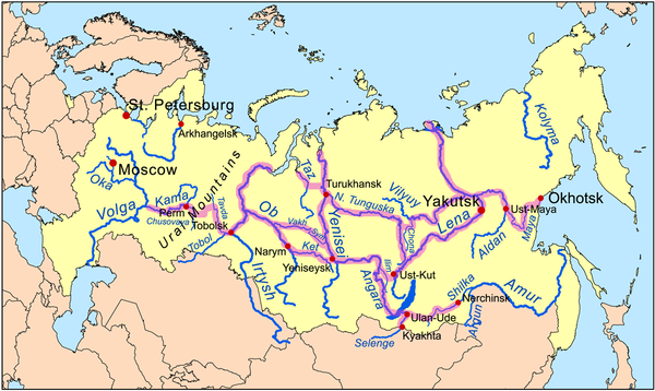
Ob Basin: Near Tobolsk was the capital of the Khanate of Sibir, which was conquered in 1582. North down the Irtysh to its juncture
with the Ob River
. 750km up the Ob to Narym
(1594), up the Ket River
(1602) about 300 km to its headwaters.
Here a portage leads to the Yenisei River
at Yeniseysk
(1619). Yeniseysk is about 1400 km from Tobolsk and 3200 km from Moscow..
OR: from the Irtysh-Ob juncture 450 km up the Ob to the Vakh, 500 km up the Vakh, portage to the Sym, down it to the Yenesei, upstream to Yenisesk.
Yenisey and Lena Basins: Yeniseysk is on the Yenisei River
just north of its juncture with the Angara River
. From Yeniseysk east up the Angara
to the Ilim River
, upstream to Ilimsk
(1630), portage to Kuta River
, short trip downstream to Ust-Kut
(1631) on the Lena River
. From here
northeast down the Lena
about 1400 km to Yakutsk
, which is 4900 km east of Moscow. Yakutsk is a major stopping point and administrative center.
Then 125 km up the Lena to the Aldan, up the Aldan River
to Ust-Maya
, then up the Maya River
or its right branch the Yudoma River.
Okhotsk: From either of the last two, it is about 150 km over 2000 ft mountains to the Pacific at Okhotsk
(1643).
Pack horses were used here. Okhotsk is 800 km east
southeast of Yakutsk and 5,600 km east of Moscow. After 1712 there were shipbuilding facilities at Okhotsk, allowing sea travel to the
Kamchatka Peninsula
, the Kuril Islands
, the Aleutian Islands and Alaska.
To the Amur:
From 1643 to 1689 the Russians attempted to penetrate from the Lena south to the Amur region but were driven back by the Manchus. See Russian-Manchu border conflicts
. From 1689 to 1859 the Russo-Chinese border was the Argun River
and the Stanovoy Mountains. In 1859 Russia annexed the
Amur region. From the west, the Russians penetrated to Ulan-Ude
(1666), Chita (1653) and Nerchinsk
(1654) toward the Argun. From 1727 much Russo-Chinese trade shifted to Kyakhta
near where the Selenge River crosses the current Russo-Mongol border.
navigated the White and Barents Seas. At some date, they entered the Ob Gulf or portaged across the
Yamal Peninsula
. From the Gulf of Ob
to the Taz Estuary
, up the Taz River
, past Mangazeya
(1601), portage to Yanov Stan on the Turukhan River
, leading to
Turukhansk
(1607) on the Yenisei at its juncture with the Lower Tunguska
. East up the Lower Tunguska. Where it turns south, portage to the
Chona River, a tributary of the Vilyuy River - the junction of these two rivers has now been flooded, forming the Viluyskoe Reservoir. East along the Vilyuy to the Lena River
, and then up the Lena to Yakutsk.
It was also possible to continue
down the Lower Tunguska to near Kirensk
(1630) (175 km northeast of Ust-Kut), make a short portage to the Lena, and down the Lena to Yakutsk.
Yakutsk is about 2400 km from the Taz Estuary.
After about 1700 most trade shifted south and the route west of Turukhansk was largely abandoned.
, along the coast to the mouth of the Kolyma River
, up to Bolshoy Anyuy River
, portage, down the Anadyr River
to the Pacific(1650). The area northeast of this route was avoided because of the warlike Chukchis. About 1700 Russians entered the Kamchatka Peninsula
from Okhotsk and the Anadyr. It is 1800 km from Yakutsk to the Bering Strait.
in 1566, Russia expanded southeast around the southern base of the Urals. This involved increasing political control over the Nogai Horde
, the Kalmyks and the northern Kazakhs
, followed by varying degrees of peasant colonization. Another route was up the Irtysh
toward the Altai country (Semipalitinsk, 1718).
 The southern border of Siberia corresponds to the forest-steppe boundary. Russian penetration of Asia was confined to the forest zone because the cossacks had the skills to travel through river and forest, because the native peoples were few and weak and because their expansion was paid for by the fur trade. Unlike Russia proper, there was little attempt to penetrate the steppe. Road
building began in the 1730s. Although there were always some peasants, massive peasant colonization did not begin until the 1860s. The Trans-Siberian Railway
began in 1891. In the twentieth century highways
were built, but the stretch north of the Amur is still not complete. Naturally, all this development took place as far south as possible. The result is a pattern in which the Russians form a long narrow belt along the southern border with extensions northward, mainly to where minerals can be found. The rivers are still used, but largely for north-south transport to and from the Trans-Siberian Railway.
Russia
Russia or , officially known as both Russia and the Russian Federation , is a country in northern Eurasia. It is a federal semi-presidential republic, comprising 83 federal subjects...
n Siberia
Siberia
Siberia is an extensive region constituting almost all of Northern Asia. Comprising the central and eastern portion of the Russian Federation, it was part of the Soviet Union from its beginning, as its predecessor states, the Tsardom of Russia and the Russian Empire, conquered it during the 16th...
before the 1730s, when roads
Siberian Route
The Siberian Route , also known as the Moscow Route and Great Route , was a historic route that connected European Russia to Siberia and China. Previously Siberian transport had been mostly by river via Siberian River Routes...
began to be built. The rivers also were of primary importance in the process of Russian exploration and colonisation
Russian conquest of Siberia
The Russian conquest of Siberia took place in the 16th and 17th centuries, when the Siberian Khanate had become a loose political structure of vassalages which were becoming undermined by the activities of Russian explorers who, though numerically outnumbered, pressured the various family-based...
of vast Siberian territories. Since the three great
Siberian rivers, Ob River
Ob River
The Ob River , also Obi, is a major river in western Siberia, Russia and is the world's seventh longest river. It is the westernmost of the three great Siberian rivers that flow into the Arctic Ocean .The Gulf of Ob is the world's longest estuary.-Names:The Ob is known to the Khanty people as the...
, Yenisei River
Yenisei River
Yenisei , also written as Yenisey, is the largest river system flowing to the Arctic Ocean. It is the central of the three great Siberian rivers that flow into the Arctic Ocean...
and Lena River
Lena River
The Lena is the easternmost of the three great Siberian rivers that flow into the Arctic Ocean . It is the 11th longest river in the world and has the 9th largest watershed...
all flow into the Arctic Ocean, the problem was to find parts or branches
of these rivers that flow approximately east-west and find short portage
Portage
Portage or portaging refers to the practice of carrying watercraft or cargo over land to avoid river obstacles, or between two bodies of water. A place where this carrying occurs is also called a portage; a person doing the carrying is called a porter.The English word portage is derived from the...
s between them. Since Siberia is relatively flat, portages were usually
short. Because of this, and the weakness of the Siberian tribes, Russian Cossacks were able to expand from the Urals to the Pacific in only
60 years (1582-1643).
Southern Route
( distances are straight lines and only approximate. Siberian rivers can be very crooked. Dates are usually the date of first Russian settlement.)Over the Urals: From the Volga River
Volga River
The Volga is the largest river in Europe in terms of length, discharge, and watershed. It flows through central Russia, and is widely viewed as the national river of Russia. Out of the twenty largest cities of Russia, eleven, including the capital Moscow, are situated in the Volga's drainage...
, up the Kama
Kama
Kāma is often translated from Sanskrit as sexual desire, sexual pleasure, sensual gratification, sexual fulfillment, or eros54654564+more broadly mean desire, wish, passion, longing, pleasure of the senses, the aesthetic enjoyment of life, affection, or love, without sexual connotations.-Kama in...
to Perm
Perm
Perm is a city and the administrative center of Perm Krai, Russia, located on the banks of the Kama River, in the European part of Russia near the Ural Mountains. From 1940 to 1957 it was named Molotov ....
(1472), then up the Chusovaya River. The Urals here are only
about 350 meters high, about 150 meters above the surrounding lowlands. Down either the Tavda River
Tavda River
The Tavda River is a Siberian river that drains part of the central Ural mountains into the Tobol River. It is north of the Tura River and south of the Konda River. It is located in Sverdlovsk Oblast and Tyumen Oblast. It is formed by the confluence of the Lozva and Sosva Rivers. The length of...
or Tura River
Tura River
Tura River , also known as Dolgaya River ) is a historically important Siberian river which flows eastward from the central Ural Mountains into the Tobol River, a part of the Ob River basin. The main town is Tyumen....
and a short way
up the Tobol River
Tobol River
Tobol is a river in Kurgan and Tyumen Oblasts in Russia and Kazakhstan, left tributary of the Irtysh. The length of the Tobol River is 1591 km. The area of its drainage basin is 426,000 km². Average discharge at mouth is 805 m³/s. The lower reaches of the river freeze up in late October -...
to its juncture with the Irtysh River at Tobolsk
Tobolsk
Tobolsk is a town in Tyumen Oblast, Russia, located at the confluence of the Tobol and Irtysh Rivers. It is a historic capital of Siberia. Population: -History:...
(1582). Tobolsk is about 700 km east of Perm and 1800 km east
of Moscow..
((This was the approximate route used by Yermak. The Siberian Route
Siberian Route
The Siberian Route , also known as the Moscow Route and Great Route , was a historic route that connected European Russia to Siberia and China. Previously Siberian transport had been mostly by river via Siberian River Routes...
, a road begun in the 1730s, ran southeast from Perm to Kungur
Kungur
Kungur is a town in the southeast of Perm Krai, Russia, located in the Ural Mountains at the inflowing of the Iren and Shakhva Rivers into the Sylva River . Kungur was founded in 1663 and granted town status in 1781. It serves as the administrative center of Kungursky District, although it is not...
, then over another
low pass to Yekaterinburg
Yekaterinburg
Yekaterinburg is a major city in the central part of Russia, the administrative center of Sverdlovsk Oblast. Situated on the eastern side of the Ural mountain range, it is the main industrial and cultural center of the Urals Federal District with a population of 1,350,136 , making it Russia's...
(1723) and Tobolsk
Tobolsk
Tobolsk is a town in Tyumen Oblast, Russia, located at the confluence of the Tobol and Irtysh Rivers. It is a historic capital of Siberia. Population: -History:...
. By 1885 there was a railway from Perm to Yekaterinburg. Another branch of the Trans-Siberian Railway
Trans-Siberian Railway
The Trans-Siberian Railway is a network of railways connecting Moscow with the Russian Far East and the Sea of Japan. It is the longest railway in the world...
(1891) goes south of the Urals through Chelyabinsk
Chelyabinsk
Chelyabinsk is a city and the administrative center of Chelyabinsk Oblast, Russia, located in the northwestern side of the oblast, south of Yekaterinburg, just to the east of the Ural Mountains, on the Miass River. Population: -History:...
(1736), Omsk
Omsk
-History:The wooden fort of Omsk was erected in 1716 to protect the expanding Russian frontier along the Ishim and the Irtysh rivers against the Kyrgyz nomads of the Steppes...
(1716) and Novosibirsk
Novosibirsk
Novosibirsk is the third-largest city in Russia, after Moscow and Saint Petersburg, and the largest city of Siberia, with a population of 1,473,737 . It is the administrative center of Novosibirsk Oblast as well as of the Siberian Federal District...
(1893).))
Ob Basin: Near Tobolsk was the capital of the Khanate of Sibir, which was conquered in 1582. North down the Irtysh to its juncture
with the Ob River
Ob River
The Ob River , also Obi, is a major river in western Siberia, Russia and is the world's seventh longest river. It is the westernmost of the three great Siberian rivers that flow into the Arctic Ocean .The Gulf of Ob is the world's longest estuary.-Names:The Ob is known to the Khanty people as the...
. 750km up the Ob to Narym
Narym
Narym is a village in Parabelsky District of Tomsk Oblast, Russia, located on the banks of the Ob River near its confluence with the Ket River, from the village of Parabel...
(1594), up the Ket River
Ket River
right|thumb|300px|The Ket was a part of the [[Siberian River Routes]] - double clickKet River , also known in its upper reaches as the Big Ket River is a river in the Krasnoyarsk Krai and Tomsk Oblast in Russia, a right tributary of the Ob River. The length of the Ket River is 1,621 km. The area...
(1602) about 300 km to its headwaters.
Here a portage leads to the Yenisei River
Yenisei River
Yenisei , also written as Yenisey, is the largest river system flowing to the Arctic Ocean. It is the central of the three great Siberian rivers that flow into the Arctic Ocean...
at Yeniseysk
Yeniseysk
Yeniseysk is a town in Krasnoyarsk Krai, Russia, located on the Yenisei River. Population: 20,000 .Yeniseysk was founded in 1619 as a stockaded town—the first town on the Yenisei River. It played an important role in Russian colonization of East Siberia in the 17th–18th centuries...
(1619). Yeniseysk is about 1400 km from Tobolsk and 3200 km from Moscow..
OR: from the Irtysh-Ob juncture 450 km up the Ob to the Vakh, 500 km up the Vakh, portage to the Sym, down it to the Yenesei, upstream to Yenisesk.
Yenisey and Lena Basins: Yeniseysk is on the Yenisei River
Yenisei River
Yenisei , also written as Yenisey, is the largest river system flowing to the Arctic Ocean. It is the central of the three great Siberian rivers that flow into the Arctic Ocean...
just north of its juncture with the Angara River
Angara River
The Angara River is a long river in Irkutsk Oblast and Krasnoyarsk Krai, south-east Siberia, Russia. It is the only river flowing out of Lake Baikal, and is the headwater tributary of the Yenisei River....
. From Yeniseysk east up the Angara
to the Ilim River
Ilim River
Ilim River is a river in Irkutsk Oblast in Russia, a right tributary of the Angara River. It flows north between and parallel to the Angara and Lena Rivers, and then swings west to join the Angara 40km south of Ust-Ilimsk....
, upstream to Ilimsk
Ilimsk
Ilimsk was a small town in Siberia, within today's Irkutsk Oblast of Russia. The town was flooded by the Ust-Ilimsk Reservoir in the mid-1970s....
(1630), portage to Kuta River
Kuta River
The Kuta River is a Siberian river north of Lake Baikal in Irkutsk Oblast, Russia, that flows into the Lena River at Ust-Kut. With its right tributary, the Kupa River, it forms a ‘T’ shape with the flat head pointing west and the point at Ust-Kut....
, short trip downstream to Ust-Kut
Ust-Kut
Ust-Kut is a town in Irkutsk Oblast, Russia. Located on a western loop of the Lena River, it spreads out over along the left bank, near the point where the Kuta River joins from the west. The town's name means 'mouth of the river Kuta' in Russian, with the name Kuta coming from an Evenk word...
(1631) on the Lena River
Lena River
The Lena is the easternmost of the three great Siberian rivers that flow into the Arctic Ocean . It is the 11th longest river in the world and has the 9th largest watershed...
. From here
northeast down the Lena
about 1400 km to Yakutsk
Yakutsk
With a subarctic climate , Yakutsk is the coldest city, though not the coldest inhabited place, on Earth. Average monthly temperatures range from in July to in January. The coldest temperatures ever recorded on the planet outside Antarctica occurred in the basin of the Yana River to the northeast...
, which is 4900 km east of Moscow. Yakutsk is a major stopping point and administrative center.
Then 125 km up the Lena to the Aldan, up the Aldan River
Aldan River
The Aldan River is the second-longest tributary of the Lena River in the Sakha Republic in eastern Siberia. The river is 2,273 km long, of which around 1,600 km is navigable. It was part of the River Route to Okhotsk...
to Ust-Maya
Ust-Maya
Ust-Maya is an urban locality and the administrative center of Ust-Maysky District of the Sakha Republic, Russia, located at the confluence of the Maya and Aldan Rivers, southeast of Yakutsk. Population:...
, then up the Maya River
Maya River
Maya River is a river in Khabarovsk Krai and Sakha, Russia. It is a right tributary of the Aldan River of the Lena basin. The length of the river is 1053 km. The area of its basin 171,000 km². The Maya River freezes up in late October and stays under the ice until May. The Yudoma River is one of...
or its right branch the Yudoma River.
Okhotsk: From either of the last two, it is about 150 km over 2000 ft mountains to the Pacific at Okhotsk
Okhotsk
Okhotsk is an urban locality and a seaport at the mouth of the Okhota River on the Sea of Okhotsk, in Okhotsky District, Khabarovsk Krai, Russia. Population: 4,470 ;...
(1643).
Pack horses were used here. Okhotsk is 800 km east
southeast of Yakutsk and 5,600 km east of Moscow. After 1712 there were shipbuilding facilities at Okhotsk, allowing sea travel to the
Kamchatka Peninsula
Kamchatka Peninsula
The Kamchatka Peninsula is a peninsula in the Russian Far East, with an area of . It lies between the Pacific Ocean to the east and the Sea of Okhotsk to the west...
, the Kuril Islands
Kuril Islands
The Kuril Islands , in Russia's Sakhalin Oblast region, form a volcanic archipelago that stretches approximately northeast from Hokkaidō, Japan, to Kamchatka, Russia, separating the Sea of Okhotsk from the North Pacific Ocean. There are 56 islands and many more minor rocks. It consists of Greater...
, the Aleutian Islands and Alaska.
To the Amur:
From 1643 to 1689 the Russians attempted to penetrate from the Lena south to the Amur region but were driven back by the Manchus. See Russian-Manchu border conflicts
Russian-Manchu border conflicts
The Russian–Manchu border conflicts were a series of intermittent skirmishes between the Manchus and the Cossacks in which the Cossacks tried and failed to gain the land north of the Amur River...
. From 1689 to 1859 the Russo-Chinese border was the Argun River
Argun River
Argun River may refer to*Argun River , in Georgia and Russia*Argun River , part of the Russia–China border...
and the Stanovoy Mountains. In 1859 Russia annexed the
Amur region. From the west, the Russians penetrated to Ulan-Ude
Ulan-Ude
Ulan-Ude is the capital city of the Republic of Buryatia, Russia, located about southeast of Lake Baikal on the Uda River at its confluence with the Selenga...
(1666), Chita (1653) and Nerchinsk
Nerchinsk
Nerchinsk is a town and the administrative center of Nerchinsky District of Zabaykalsky Krai, Russia, located east of Lake Baikal, east of Chita, and about west of the Chinese border on the left bank of the Nercha River, above its confluence with the Shilka River, which flows into the Amur...
(1654) toward the Argun. From 1727 much Russo-Chinese trade shifted to Kyakhta
Kyakhta
Kyakhta is a town in the Republic of Buryatia, Russia, located on the Kyakhta River near the Russian-Mongolian border. Population: The town stands directly opposite the Mongolian border town of Altanbulag.-History:...
near where the Selenge River crosses the current Russo-Mongol border.
Northern Route
From at least the 12th century, Russian PomorsPomors
Pomors or Pomory are Russian settlers and their descendants on the White Sea coast. It is also term of self-identification for the descendants of Russian, primarily Novgorod, settlers of Pomorye , living on the White Sea coasts and the territory whose southern border lies on a watershed which...
navigated the White and Barents Seas. At some date, they entered the Ob Gulf or portaged across the
Yamal Peninsula
Yamal Peninsula
The Yamal Peninsula , located in Yamal-Nenets autonomous district of northwest Siberia, Russia, extends roughly 700 km and is bordered principally by the Kara Sea, Baydaratskaya Bay on the west, and by the Gulf of Ob on the east...
. From the Gulf of Ob
Gulf of Ob
The Gulf of Ob is a gigantic bay of the Arctic Ocean, located in Northern Russia at the head the mouth of the Ob River....
to the Taz Estuary
Taz Estuary
The Taz Estuary is a long gulf formed by the Taz River.It consists of a roughly 250 km long estuary that begins in the area of Tazovskiy town and ends in the Gulf of Ob, which is connected with the Kara Sea...
, up the Taz River
Taz River
The Taz is a river located in western Siberia, has a length of 1401 km and drains a basin estimated at 150,000 km².The Taz River flows into the Tazovskaya Guba, a roughly 250 km long estuary that begins in the area of Tazovskiy town and ends in the Gulf of Ob...
, past Mangazeya
Mangazeya
Mangazeya was a Northwest Siberian trans-Ural trade colony and later city in the 16-17th centuries. Founded in 1600, it was situated on the Taz River, between the lower courses of the Ob and Yenisei Rivers flowing into the Arctic Ocean....
(1601), portage to Yanov Stan on the Turukhan River
Turukhan River
Turukhan River is a river in northern Krasnoyarsk Krai in Russia. It is a left tributary of the Yenisei River. The length of the river is 639 km. The area of its basin is 35,800 km². The Turukhan River freezes up in October and stays under the ice until late May - first half of June. Its main...
, leading to
Turukhansk
Turukhansk
Turukhansk is a village in Krasnoyarsk Krai, Russia. It is located 1474 km north of Krasnoyarsk, at the confluence of the Yenisei and Lower Tunguska rivers. The Turukhan River joins the Yenisei about 20 km northwest. Population: 4,849 ; 8,900 ; 200...
(1607) on the Yenisei at its juncture with the Lower Tunguska
Lower Tunguska
Nizhnyaya Tunguska — is a river in Siberia, Russia, flows through the Irkutsk Oblast and the Krasnoyarsk Krai. The river is a right tributary of the Yenisei joining it at Turukhansk . Settlements on the river include Tura, Yukti and Simenga...
. East up the Lower Tunguska. Where it turns south, portage to the
Chona River, a tributary of the Vilyuy River - the junction of these two rivers has now been flooded, forming the Viluyskoe Reservoir. East along the Vilyuy to the Lena River
Lena River
The Lena is the easternmost of the three great Siberian rivers that flow into the Arctic Ocean . It is the 11th longest river in the world and has the 9th largest watershed...
, and then up the Lena to Yakutsk.
It was also possible to continue
down the Lower Tunguska to near Kirensk
Kirensk
Kirensk is a town and the administrative center of Kirensky District of Irkutsk Oblast, Russia, located at the confluence of the Kirenga and the Lena Rivers, north of Irkutsk, north-northwest of the northern tip of Lake Baikal, and northeast of Ust-Kut...
(1630) (175 km northeast of Ust-Kut), make a short portage to the Lena, and down the Lena to Yakutsk.
Yakutsk is about 2400 km from the Taz Estuary.
After about 1700 most trade shifted south and the route west of Turukhansk was largely abandoned.
Northeast
From the mouth of the Lena RiverLena River
The Lena is the easternmost of the three great Siberian rivers that flow into the Arctic Ocean . It is the 11th longest river in the world and has the 9th largest watershed...
, along the coast to the mouth of the Kolyma River
Kolyma River
The Kolyma River is a river in northeastern Siberia, whose basin covers parts of the Sakha Republic, Chukotka Autonomous Okrug, and Magadan Oblast of Russia. Itrises in the mountains north of Okhotsk and Magadan, in the area of and...
, up to Bolshoy Anyuy River
Bolshoy Anyuy River
The Bolshoy Anyuy River or Bolshoy Anyui River is a river in the Kolyma River basin in Far East Siberia. It flows roughly westwards and passes through the sparsely populated areas of Chukotka...
, portage, down the Anadyr River
Anadyr River
Anadyr is a river in the far northeast Siberia which flows into Anadyr Bay of the Bering Sea and drains much of the interior of Chukotka Autonomous Okrug. Its basin corresponds to the Anadyrsky District of Chukotka....
to the Pacific(1650). The area northeast of this route was avoided because of the warlike Chukchis. About 1700 Russians entered the Kamchatka Peninsula
Kamchatka Peninsula
The Kamchatka Peninsula is a peninsula in the Russian Far East, with an area of . It lies between the Pacific Ocean to the east and the Sea of Okhotsk to the west...
from Okhotsk and the Anadyr. It is 1800 km from Yakutsk to the Bering Strait.
Southwest
After the conquest of AstrakhanAstrakhan
Astrakhan is a major city in southern European Russia and the administrative center of Astrakhan Oblast. The city lies on the left bank of the Volga River, close to where it discharges into the Caspian Sea at an altitude of below the sea level. Population:...
in 1566, Russia expanded southeast around the southern base of the Urals. This involved increasing political control over the Nogai Horde
Nogai Horde
The Nogai Horde was a confederation of about eighteen Turkic and Mongol tribes that occupied the Pontic-Caspian steppe from about 1500 until they were pushed west by the Kalmyks and south by the Russians in the 17th century. The Mongol tribe called the Manghits constituted a core of the Horde...
, the Kalmyks and the northern Kazakhs
Kazakhs
The Kazakhs are a Turkic people of the northern parts of Central Asia ....
, followed by varying degrees of peasant colonization. Another route was up the Irtysh
Irtysh
The Irtysh River is a river in Siberia and is the chief tributary of the Ob River. Its name means White River. Irtysh's main affluent is the Tobol River...
toward the Altai country (Semipalitinsk, 1718).
Decline of the River Route
Siberian Route
The Siberian Route , also known as the Moscow Route and Great Route , was a historic route that connected European Russia to Siberia and China. Previously Siberian transport had been mostly by river via Siberian River Routes...
building began in the 1730s. Although there were always some peasants, massive peasant colonization did not begin until the 1860s. The Trans-Siberian Railway
Trans-Siberian Railway
The Trans-Siberian Railway is a network of railways connecting Moscow with the Russian Far East and the Sea of Japan. It is the longest railway in the world...
began in 1891. In the twentieth century highways
Trans-Siberian Highway
The Trans-Siberian Highway is the unofficial name for a network of federal highways that span the width of Russia from the Baltic Sea of the Atlantic Ocean to the Japan Sea of the Pacific Ocean. In the Asian Highway Network, the route is known as AH6. It stretches over from St. Petersburg to...
were built, but the stretch north of the Amur is still not complete. Naturally, all this development took place as far south as possible. The result is a pattern in which the Russians form a long narrow belt along the southern border with extensions northward, mainly to where minerals can be found. The rivers are still used, but largely for north-south transport to and from the Trans-Siberian Railway.