

Cape Reinga
Encyclopedia
Cape Reinga is the northwesternmost tip of the Aupouri Peninsula
, at the northern end of the North Island
of New Zealand
. Cape Reinga is located over 100 km north of the nearest small town of Kaitaia
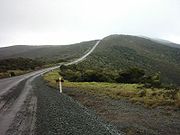
. State Highway 1 extends all the way to the Cape, but until 2010 was unsealed gravel road
for the last 19km. Suitable vehicles can also travel much of the way via Ninety Mile Beach
and Te Paki stream bed.
The name of the cape comes from the Māori word 'Reinga', meaning the 'Underworld'. Another Māori name is 'Te Rerenga Wairua', meaning the leaping-off place of spirits. Both refer to the Māori belief that the cape is the point where the spirits of the dead enter the underworld.
As of January 2007, Cape Reinga is on the tentative list of UNESCO
waiting to receive World Heritage Site
status. The cape is already a favourite tourist attraction, with over 120,000 visitors a year and around 1,300 cars arriving per day during peak season. Visitor numbers are growing by about 5% a year, and the increase is likely to become even more now that the road to the cape is fully sealed.
to the west and the Pacific Ocean
to the east. From the lighthouse it is possible to watch the tidal race
, as the two seas clash to create unsettled waters just off the coast. The Māori refer to this as the meeting of Te Moana-a-Rehua, 'the sea of Rehua' with Te Tai-o-Whitirea, 'the sea of Whitirea', Rehua and Whitirea being a male and a female respectively.
The cape is often mistakenly thought of as being the northernmost point of the North Island, and thus, of mainland New Zealand. However, North Cape
's Surville Cliffs
, 30 km east of Cape Reinga, are slightly further north. Another headland just to the west of Cape Reinga is Cape Maria van Diemen
, which was discovered and named by the Dutch explorer Abel Tasman
during his journey in 1642 and thought of by him to be the northernmost point of the newly-discovered country he named 'Staten Landt'.
, the spirits of the dead travel to Cape Reinga on their journey to the afterlife to leap off the headland and climb the roots of the 800 year old tree and descend to the underworld to return to their traditional homeland of Hawaiki
, using the Te Ara Wairua, the 'Spirits' pathway'. At Cape Reinga they depart the mainland. They turn briefly at the Three Kings Islands
for one last look back towards the land, then continue on their journey.
A spring in the hillside, Te Waiora-a-Tāne (the 'Living waters of Tāne'), also played an important role in Māori ceremonial burials, representing a spiritual cleansing of the spirits, with water of the same name used in burial rites all over New Zealand. This significance lasted until the local population mostly converted to Christianity, and the spring was capped with a reservoir, with little protest from the mostly converted population of the area. However, the spring soon disappeared and only reappeared at the bottom of the cliff, making the reservoir useless.
 Recently (2007), protests by Māori as well as increases in tourist numbers have led the Department of Conservation to announce that the current public carpark and toilet facilities, which are intruding on traditionally sacred ground, would be moved further away from the cape and extended, at a cost of NZ$ 6.5 million (details see external links below). The road to the Cape, one of the last stretches of State Highway 1 was only recently sealed following three years of work and include extensive roadside revegetation with over 150,000 plants to prevent erosion. In March 2009, the works on the visitor facilities were completed.
at Cape Reinga was built in 1941 and first lit during May of that year, replacing a lighthouse located on nearby Motuopao Island, which had been built 1879. In 1987, the lighthouse was fully automated and the lighthouse keepers were withdrawn. The previous 1000 watt light has since been replaced with a 50 watt flashing beacon.
Aupouri Peninsula
The Aupouri Peninsula is a tombolo at the northern tip of the North Island of New Zealand. It projects between the Tasman Sea to the west and the Pacific Ocean to the east...
, at the northern end of the North Island
North Island
The North Island is one of the two main islands of New Zealand, separated from the much less populous South Island by Cook Strait. The island is in area, making it the world's 14th-largest island...
of New Zealand
New Zealand
New Zealand is an island country in the south-western Pacific Ocean comprising two main landmasses and numerous smaller islands. The country is situated some east of Australia across the Tasman Sea, and roughly south of the Pacific island nations of New Caledonia, Fiji, and Tonga...
. Cape Reinga is located over 100 km north of the nearest small town of Kaitaia
Kaitaia
Kaitaia is a town in the far north region of New Zealand, at the base of the Aupouri Peninsula which is about 160 km northwest of Whangarei. It is the last major settlement on the main road north to the capes and bays on the peninsula...
. State Highway 1 extends all the way to the Cape, but until 2010 was unsealed gravel road
Gravel road
A gravel road is a type of unpaved road surfaced with gravel that has been brought to the site from a quarry or stream bed. They are common in less-developed nations, and also in the rural areas of developed nations such as Canada and the United States. In New Zealand, they are known as 'metal roads'...
for the last 19km. Suitable vehicles can also travel much of the way via Ninety Mile Beach
Ninety Mile Beach, New Zealand
Ninety Mile Beach is a beach located on the western coast of the far north of the North Island of New Zealand. It stretches from just west of Kaitaia towards Cape Reinga along the Aupouri Peninsula. It begins close to the headland of Reef Point, to the west of Ahipara Bay, sweeping briefly...
and Te Paki stream bed.
The name of the cape comes from the Māori word 'Reinga', meaning the 'Underworld'. Another Māori name is 'Te Rerenga Wairua', meaning the leaping-off place of spirits. Both refer to the Māori belief that the cape is the point where the spirits of the dead enter the underworld.
As of January 2007, Cape Reinga is on the tentative list of UNESCO
UNESCO
The United Nations Educational, Scientific and Cultural Organization is a specialized agency of the United Nations...
waiting to receive World Heritage Site
World Heritage Site
A UNESCO World Heritage Site is a place that is listed by the UNESCO as of special cultural or physical significance...
status. The cape is already a favourite tourist attraction, with over 120,000 visitors a year and around 1,300 cars arriving per day during peak season. Visitor numbers are growing by about 5% a year, and the increase is likely to become even more now that the road to the cape is fully sealed.
Meeting of the seas
Cape Reinga is generally considered the separation marker between the Tasman SeaTasman Sea
The Tasman Sea is the large body of water between Australia and New Zealand, approximately across. It extends 2,800 km from north to south. It is a south-western segment of the South Pacific Ocean. The sea was named after the Dutch explorer Abel Janszoon Tasman, the first recorded European...
to the west and the Pacific Ocean
Pacific Ocean
The Pacific Ocean is the largest of the Earth's oceanic divisions. It extends from the Arctic in the north to the Southern Ocean in the south, bounded by Asia and Australia in the west, and the Americas in the east.At 165.2 million square kilometres in area, this largest division of the World...
to the east. From the lighthouse it is possible to watch the tidal race
Tidal race
Tidal race is a natural occurrence whereby a fast moving tide passes through a constriction resulting in the formation of waves, eddies and hazardous currents...
, as the two seas clash to create unsettled waters just off the coast. The Māori refer to this as the meeting of Te Moana-a-Rehua, 'the sea of Rehua' with Te Tai-o-Whitirea, 'the sea of Whitirea', Rehua and Whitirea being a male and a female respectively.
The cape is often mistakenly thought of as being the northernmost point of the North Island, and thus, of mainland New Zealand. However, North Cape
North Cape, New Zealand
North Cape is located at the northern end of the North Auckland Peninsula in the North Island of New Zealand . It is the northeastern tip of the Aupouri Peninsula and lies 30 km east of Cape Reinga. The name is sometimes used to refer just to the cape which is known in Māori as Otou and which...
's Surville Cliffs
Surville Cliffs
The Surville Cliffs are the northernmost point of the mainland of New Zealand. They are situated on the North Cape of the North Island, 30 kilometres to the east of Cape Reinga , and three kilometres more northerly...
, 30 km east of Cape Reinga, are slightly further north. Another headland just to the west of Cape Reinga is Cape Maria van Diemen
Cape Maria van Diemen
Cape Maria van Diemen is the westernmost point of the North Island of New Zealand. Being close to the northern tip of the Aupouri Peninsula, many people in New Zealand also incorrectly believe it to be the northernmost point...
, which was discovered and named by the Dutch explorer Abel Tasman
Abel Tasman
Abel Janszoon Tasman was a Dutch seafarer, explorer, and merchant, best known for his voyages of 1642 and 1644 in the service of the VOC . His was the first known European expedition to reach the islands of Van Diemen's Land and New Zealand and to sight the Fiji islands...
during his journey in 1642 and thought of by him to be the northernmost point of the newly-discovered country he named 'Staten Landt'.
Māori mythology
According to mythologyMaori mythology
Māori mythology and Māori traditions are the two major categories into which the legends of the Māori of New Zealand may usefully be divided...
, the spirits of the dead travel to Cape Reinga on their journey to the afterlife to leap off the headland and climb the roots of the 800 year old tree and descend to the underworld to return to their traditional homeland of Hawaiki
Hawaiki
In Māori mythology, Hawaiki is the homeland of the Māori, the original home of the Māori, before they travelled across the sea to New Zealand...
, using the Te Ara Wairua, the 'Spirits' pathway'. At Cape Reinga they depart the mainland. They turn briefly at the Three Kings Islands
Three Kings Islands
The Three Kings Islands or Manawa Islands are a group of 13 islands about northwest of Cape Reinga, the northernmost point of the North Island of New Zealand, where the South Pacific Ocean and Tasman Sea converge. They measure about 4.86 km² in area...
for one last look back towards the land, then continue on their journey.
A spring in the hillside, Te Waiora-a-Tāne (the 'Living waters of Tāne'), also played an important role in Māori ceremonial burials, representing a spiritual cleansing of the spirits, with water of the same name used in burial rites all over New Zealand. This significance lasted until the local population mostly converted to Christianity, and the spring was capped with a reservoir, with little protest from the mostly converted population of the area. However, the spring soon disappeared and only reappeared at the bottom of the cliff, making the reservoir useless.
Restoration
Climate
Cape Reinga, as well as most parts of New Zealand, has a very mild climate with little differences between the seasons and high precipitation.Lighthouse
The lighthouseLighthouse
A lighthouse is a tower, building, or other type of structure designed to emit light from a system of lamps and lenses or, in older times, from a fire, and used as an aid to navigation for maritime pilots at sea or on inland waterways....
at Cape Reinga was built in 1941 and first lit during May of that year, replacing a lighthouse located on nearby Motuopao Island, which had been built 1879. In 1987, the lighthouse was fully automated and the lighthouse keepers were withdrawn. The previous 1000 watt light has since been replaced with a 50 watt flashing beacon.
External links
- Cape Reinga (from the New Zealand Department of Conservation (DOC)New Zealand Department of ConservationThe Department of Conservation , commonly known by its acronym, "DOC", is the state sector organisation which deals with the conservation of New Zealand’s natural and historic heritage...
website) - Cape Reinga work / Healing Te Rerenga Wairua (information on the new visitor centre works)