

Bruce Highway
Encyclopedia
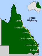
Queensland
Queensland is a state of Australia, occupying the north-eastern section of the mainland continent. It is bordered by the Northern Territory, South Australia and New South Wales to the west, south-west and south respectively. To the east, Queensland is bordered by the Coral Sea and Pacific Ocean...
, Australia
Australia
Australia , officially the Commonwealth of Australia, is a country in the Southern Hemisphere comprising the mainland of the Australian continent, the island of Tasmania, and numerous smaller islands in the Indian and Pacific Oceans. It is the world's sixth-largest country by total area...
. Commencing in the state capital, Brisbane
Brisbane
Brisbane is the capital and most populous city in the Australian state of Queensland and the third most populous city in Australia. Brisbane's metropolitan area has a population of over 2 million, and the South East Queensland urban conurbation, centred around Brisbane, encompasses a population of...
, it passes through areas close to the eastern coast to Cairns in Far North Queensland
Far North Queensland
Far North Queensland, or FNQ, is the northernmost part of the Australian state of Queensland. The region, which contains a large section of the Tropical North Queensland area, stretches from the city of Cairns north to the Torres Strait...
. The route is a part of the Australian National Highway
National Highway (Australia)
thumb|right|150px|The National Highway Shield in NSW, QLD, WA, NT & TAS.The National Highway is a system of roads connecting all the States and Territories of Australia, and is the major network of highways connecting Australia's largest and most important cities.The National Highway was...
and also part of Highway 1
Highway 1 (Australia)
Australia's Highway 1 is a network of highways that circumnavigate the Australian continent, joining all mainland state capitals. At a total length of approximately it is the longest national highway in the world, longer than the Trans-Siberian Highway and the Trans-Canada Highway...
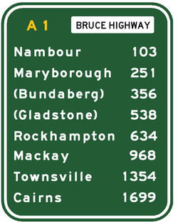
. Its length is approximately 1700 kilometres; it is entirely sealed with bitumen.
The highway is named after the former Queensland and federal politician Henry Adam Bruce. He was the state Minister for Works when the highway was named after him, in the mid 1930s. It once passed through Brisbane
Brisbane
Brisbane is the capital and most populous city in the Australian state of Queensland and the third most populous city in Australia. Brisbane's metropolitan area has a population of over 2 million, and the South East Queensland urban conurbation, centred around Brisbane, encompasses a population of...
, but was truncated at Bald Hills
Bald Hills, Queensland
Bald Hills is the northernmost suburb of the Brisbane City Council in Queensland, Australia.Bald Hills is a largely residential suburb. It is mostly surrounded by bushland, but in the last few years some of the bush areas have been cleared to make way for new residential areas...
when the recently-constructed Gateway Motorway
Gateway Motorway
The Gateway Motorway is a major motorway in Brisbane, Queensland, Australia. The Gateway Bridge is owned and operated by Queensland Motorways....
became National Highway 1 in 1994.
The Bruce Highway is the biggest traffic carrier in Queensland. The highway initially joined all the major coastal centres; however, a number of bypasses, particularly in the south, have diverted traffic around these cities in order to expedite traffic flow and ease urban congestion. As a result, the highway is constantly being shortened. The road is a dual carriageway
Dual carriageway
A dual carriageway is a class of highway with two carriageways for traffic travelling in opposite directions separated by a central reservation...
from Brisbane to Cooroy with some dual carriageway lengths at Gympie
Gympie
Gympie may refer to:* Gympie, a city in Queensland, Australia** Gympie Airport** Electoral district of Gympie** Gympie Region, its local government authority* Gympie Gympie , a stinging plant...
, many of these upgrades being completed in the 1980s (Glass House Mountains
Glass House Mountains, Queensland
Glass House Mountains is a hinterland town of the Sunshine Coast, Queensland, Australia, named after the famous Glass House Mountains of the area. It is located approximately 64 km north of Brisbane, belonging to the Sunshine Coast Regional Council local government area . Colloquially it is...
, Maryborough
Maryborough, Queensland
Maryborough is a city located on the Mary River in South East Queensland, Australia, approximately north of the state capital, Brisbane. The city is serviced by the Bruce Highway, and has a population of approximately 22,000 . It is closely tied to its neighbour city Hervey Bay which is...
) and 1990s (Nambour
Nambour, Queensland
The area now known as Nambour, was first settled in 1870. The town was then called Petrie's Creek. In 1890 the Maroochy Divisional Board was established...
, Cooroy
Cooroy, Queensland
Cooroy is a town in Queensland, Australia, located in the northern Sunshine Coast hinterland about west of Noosa Heads. Cooroy's name came from Cooroy Mountain, which was originally called Coorooey, from the Aboriginal word for possum, kurui....
).
In the south the Bruce Highway commences at the bridge over the Pine River
Pine River (Queensland)
Pine River continues after the convergence of North Pine and South Pine rivers at Lawnton in Queensland, Australia, continuing into Bramble Bay. The Brisway map reference is 440 D10.-Geographical characteristics:...
at the Gateway Motorway interchange, 21 kilometres north of Brisbane
Brisbane
Brisbane is the capital and most populous city in the Australian state of Queensland and the third most populous city in Australia. Brisbane's metropolitan area has a population of over 2 million, and the South East Queensland urban conurbation, centred around Brisbane, encompasses a population of...
central business district
Brisbane central business district
The Brisbane central business district , sometimes referred to as the city, is a suburb of Brisbane, Queensland, Australia and is located on a point on the northern bank of the Brisbane River. The triangular shaped area is bounded by the Brisbane River to the east, south and west...
. Recently, the Bruce Highway has changed its route numbering from National Highway 1 to the M1 (motorway road) or A1 (single carriageway, generally with overtaking lanes).
Several major cities along the route include Maryborough
Maryborough, Queensland
Maryborough is a city located on the Mary River in South East Queensland, Australia, approximately north of the state capital, Brisbane. The city is serviced by the Bruce Highway, and has a population of approximately 22,000 . It is closely tied to its neighbour city Hervey Bay which is...
, Rockhampton
Rockhampton
Rockhampton can refer to:* Rockhampton, Queensland is a city in Queensland, Australia* Rockhampton City, Queensland, a suburb of Rockhampton, Queensland* Electoral district of Rockhampton, Queensland, Australia...
, Mackay
Mackay, Queensland
Mackay is a city on the eastern coast of Queensland, Australia, about north of Brisbane, on the Pioneer River. Mackay is nicknamed the sugar capital of Australia because its region produces more than a third of Australia's cane sugar....
, Townsville, and Cairns. The highway passes the Glasshouse Mountains, rainforest
Rainforest
Rainforests are forests characterized by high rainfall, with definitions based on a minimum normal annual rainfall of 1750-2000 mm...
s and pastures in the Sunshine Coast
Sunshine Coast, Queensland
The Sunshine Coast is an urban area in South East Queensland, north of the state capital of Brisbane on the Pacific Ocean coastline. Although it does not have a central business district, by population it ranks as the 10th largest metropolis in Australia and the third largest in...
, the Gunalda Range (north of Gympie
Gympie
Gympie may refer to:* Gympie, a city in Queensland, Australia** Gympie Airport** Electoral district of Gympie** Gympie Region, its local government authority* Gympie Gympie , a stinging plant...
), Mount Larcom (north of Gladstone
Gladstone, Queensland
- Education :Gladstone has several primary schools, three high schools, and one university campus, Central Queensland University. It is also home to CQIT Gladstone Campus.- Recreation :...
), and the arid countryside north of Rockhampton
Rockhampton
Rockhampton can refer to:* Rockhampton, Queensland is a city in Queensland, Australia* Rockhampton City, Queensland, a suburb of Rockhampton, Queensland* Electoral district of Rockhampton, Queensland, Australia...
; after that, it passes through land predominantly used for sugar cane, crop growing and dairy
Dairy
A dairy is a business enterprise established for the harvesting of animal milk—mostly from cows or goats, but also from buffalo, sheep, horses or camels —for human consumption. A dairy is typically located on a dedicated dairy farm or section of a multi-purpose farm that is concerned...
farm
Farm
A farm is an area of land, or, for aquaculture, lake, river or sea, including various structures, devoted primarily to the practice of producing and managing food , fibres and, increasingly, fuel. It is the basic production facility in food production. Farms may be owned and operated by a single...
s and the sub-tropics and tropics
Tropics
The tropics is a region of the Earth surrounding the Equator. It is limited in latitude by the Tropic of Cancer in the northern hemisphere at approximately N and the Tropic of Capricorn in the southern hemisphere at S; these latitudes correspond to the axial tilt of the Earth...
.
Upgrades
Due to the nature of wet weather and tropical cyclone prone areas of North Queensland, Bruce Highway is prone to frequent flooding in a number of places. Following the catastrophic Queensland floods in 2010–20112010–2011 Queensland floods
A series of floods hit Australia, beginning in December 2010, primarily in the state of Queensland including its capital city, Brisbane. The floods forced the evacuation of thousands of people from towns and cities. At least seventy towns and over 200,000 people were affected. Damage initially was...
the Australian Government have commissioned a feasibility study on flood-proofing the Bruce Highway. The feasibility study is to be completed by the middle of 2011.
Bruce Highway is set to undergo redevelopment, realignment, flood-proofing and extension of dual carriageway sections on numerous stretches of the Highway. Premier Anna Bligh
Anna Bligh
Anna Maria Bligh is an Australian politician and the Premier of Queensland since 2007. The 2009 Queensland state election was the first time a female-led political party won or retained state or federal government in Australia...
announced the plans while launching the Queensland Infrastructure Plan. The works are expected to total A$2 billion and include 60 projects over a period of two decades.
A stretch of road between Cardwell
Cardwell, Queensland
Cardwell is a tropical coastal town in northeastern Queensland. It is located at the southern extremity of the Cassowary Coast. At the 2006 census, Cardwell had a population of 1,250. The Bruce Highway National Highway 1 and the North Coast railway line are the dominant transport routes;...
and Tully
Tully, Queensland
Tully is a small town in Queensland, Australia, adjacent to the Bruce Highway approximately south of Cairns by road and north of Townsville. At the 2006 census, Tully had a population of 2,457....
, which is prone to frequent flooding in the wet season, is set to undergo realignment. A new route for the highway through Townsville was under construction with the first stage of the Townsville Ring Road
Townsville Ring Road
The Townsville Ring Road, is the future A1/M1 Route that will eventually bypass the inner metro area of Townsville, Australia. The road will be built in 4 stages with the first three stages built as a two-laned main road...
(now called The Ring Road) already completed.
Upgrade to a stretch of the highway north of Townsville has been given approval, and will see the existing dual carriageway to the north extended by another 5–10 km. It will also include installation of traffic lights at Mt Low Parkway, and will be the final stage of the Ring Road link up to this section by 2015. The Queensland Main Roads Department's ultimate concept map of the development also shows that the highway will also progressively become Motorway standard by 2015, with the implementation of interchanges at various junctions.
The highway south of Cairns will also see sections of the highway to the suburb of Edmonton
Edmonton, Queensland
Edmonton used to be an independent township supporting a sugar mill, but in recent times has become a suburb of Cairns, Queensland, Australia. It is located approximately 10 km south of the centre of Cairns on the Bruce Highway and within the Cairns Region local government area...
become six lanes, with progressive dual-carriageway redevelopment of the highway to Gordonvale
Gordonvale, Queensland
Gordonvale is a small sugar-growing suburb situated in the southern end of Cairns on the Mulgrave River. At the 2006 census, Gordonvale had a population of 4,420....
. Labour candidate Jim Turnour has also put ahead that stage 1 of the Cairns Southern Motorway will begin with overpasses at Ray Jones Drive and Sheehy Road if elected.
To improve flood immunity of the highway south of Childers
Childers, Queensland
Childers is a town in southern Queensland, Australia, situated at the junction of the Bruce and Isis Highways. The township lies north of the state capital Brisbane and south-west of Bundaberg. Childers is located within Bundaberg Region Local Government Area. At the 2006 census, Childers had a...
, a higher bridge
Isis River Bridge
The Isis River Bridge is a road bridge over the Isis River south of Childers, Queensland, Australia.The bridge was built on a new and improved alignment of the Bruce Highway. It replaced the 54-year-old bridge which was prone to flooding. The new bridge will improve flood immunity as it is almost...
over the Isis River
Isis River (Queensland)
The Isis River is a river of the state of Queensland in Australia. It rises east of Childers and flows in an easterly direction where it joins the Gregory River, itself a tributary of the Burrum River....
and a new and improved road alignment is to be completed by the end of 2011.
Between Caboolture and the Gateway Motorway, the highway has been widened to eight and six lanes since 2001, the latest being the Boundary Road to Uhlmann Road section in 2007. The next section, Uhlmann Road to Bribie Island Road was completed in July 2009, and further upgrades are under review.
A new interchange is destined to be constructed at the notorious intersection of Roys Road at Beerwah
Beerwah, Queensland
Beerwah is a town on the Sunshine Coast hinterland in Queensland, Australia. It is situated north of Glass House Mountains, approximately 80 km north of Brisbane, and just south of Landsborough. The main road through Beerwah is called Steve Irwin Way. It was formerly known as the Glasshouse...
. It will also connect to the nearby Bells Creek Road, another dangerous intersection. The Nambour
Nambour, Queensland
The area now known as Nambour, was first settled in 1870. The town was then called Petrie's Creek. In 1890 the Maroochy Divisional Board was established...
Bypass has recently gone through a process of rehabilitation due to the extremely rough surface and dangerous pothole appearances during wet weather. This work was completed in 2008. As of 2010 part of a federally funded 61 km bypass of Gympie
Gympie
Gympie may refer to:* Gympie, a city in Queensland, Australia** Gympie Airport** Electoral district of Gympie** Gympie Region, its local government authority* Gympie Gympie , a stinging plant...
has commenced early works, as part of the larger Cooroy to Curra upgrade of the highway. Due to the new highway change (peaking completion in 2012), one of the schools, Federal State School, was relocated.
Highway towns
Travelling north, the following towns and small cities are found on (or very close to) the Bruce Highway.
- BrisbaneBrisbaneBrisbane is the capital and most populous city in the Australian state of Queensland and the third most populous city in Australia. Brisbane's metropolitan area has a population of over 2 million, and the South East Queensland urban conurbation, centred around Brisbane, encompasses a population of...
to MaryboroughMaryborough, QueenslandMaryborough is a city located on the Mary River in South East Queensland, Australia, approximately north of the state capital, Brisbane. The city is serviced by the Bruce Highway, and has a population of approximately 22,000 . It is closely tied to its neighbour city Hervey Bay which is...
- Caboolture (bypassed in the 1970s)
- NambourNambour, QueenslandThe area now known as Nambour, was first settled in 1870. The town was then called Petrie's Creek. In 1890 the Maroochy Divisional Board was established...
(bypassed in 1990) - GympieGympieGympie may refer to:* Gympie, a city in Queensland, Australia** Gympie Airport** Electoral district of Gympie** Gympie Region, its local government authority* Gympie Gympie , a stinging plant...
(bypass under construction)
- Maryborough to RockhamptonRockhamptonRockhampton can refer to:* Rockhampton, Queensland is a city in Queensland, Australia* Rockhampton City, Queensland, a suburb of Rockhampton, Queensland* Electoral district of Rockhampton, Queensland, Australia...
- ChildersChilders, QueenslandChilders is a town in southern Queensland, Australia, situated at the junction of the Bruce and Isis Highways. The township lies north of the state capital Brisbane and south-west of Bundaberg. Childers is located within Bundaberg Region Local Government Area. At the 2006 census, Childers had a...
- Gin GinGin Gin, QueenslandGin Gin is a small rural town located on the Bruce Highway in central Queensland, Australia, approximately 51 km west of Bundaberg and 370 km north-west of Brisbane, the state capital. The town owes its existence to its strategic location about halfway between Brisbane and Rockhampton. It...
- Miriam ValeMiriam Vale, QueenslandMiriam Vale is a town in the state of Queensland, Australia. The town is situated on the Bruce Highway, 464 km north of Brisbane, the state capital, and 170 km south of Rockhampton....
- CalliopeCalliope, QueenslandCalliope is a town located in Central Queensland, Australia. It is located near the junction of the Bruce Highway and the Dawson Highway, 20 kilometres SSW of the port city of Gladstone...
- Childers
- Rockhampton to MackayMackay, QueenslandMackay is a city on the eastern coast of Queensland, Australia, about north of Brisbane, on the Pioneer River. Mackay is nicknamed the sugar capital of Australia because its region produces more than a third of Australia's cane sugar....
- MarlboroughMarlborough, QueenslandMarlborough is a small township located north west of the city of Rockhampton in central Queensland, Australia. The town is administered by the Rockhampton Regional Council, and lies on the Bruce Highway...
- SarinaSarina, QueenslandSarina is a town in central Queensland, Australia. It is situated south of the city of Mackay, and approximately north of the city of Rockhampton. At the 2006 census, Sarina had a population of 3,285....
- Marlborough
- Mackay to Townsville
- ProserpineProserpine, Queensland-External links:* * * * *...
- BowenBowen, QueenslandBowen is a town on the eastern coast of Queensland, Australia. At the 2006 census, Bowen had a population of 7,484.-Geography:Bowen is located on the north-east coast of Australia, at exactly twenty degrees south of the equator. In fact, the twentieth parallel crosses the main street...
- Home Hill
- AyrAyr, QueenslandAyr is a town in Queensland, Australia near the delta of the Burdekin River, named after the Scottish town of Ayr by the settlers from the United Kingdom...
- Proserpine
- Townsville to Cairns
- InghamIngham, QueenslandIngham is a town in the Great Green Way region of North Queensland, Australia. The town was founded in 1864, gazetted a shire in 1879, and is the service centre for many sugarcane plantations, pioneered in the 1870s by William Ingham, for whom the town is named...
- CardwellCardwell, QueenslandCardwell is a tropical coastal town in northeastern Queensland. It is located at the southern extremity of the Cassowary Coast. At the 2006 census, Cardwell had a population of 1,250. The Bruce Highway National Highway 1 and the North Coast railway line are the dominant transport routes;...
- TullyTully, QueenslandTully is a small town in Queensland, Australia, adjacent to the Bruce Highway approximately south of Cairns by road and north of Townsville. At the 2006 census, Tully had a population of 2,457....
- InnisfailInnisfail, QueenslandInnisfail is a town located in the far north of the state of Queensland, Australia. It is the major township of the Cassowary Coast and is well renowned for its sugar and banana industries, as well as for being one of Australia's wettest towns...
- Ingham
Motorway exits
| Bruce Highway Cooroy to Bald Hills | ||
| Northbound exits | Exit number (distance from QLD/NSW border) |
Southbound exits |
| End Motorway Continues as Bruce Highway to Gympie Gympie Gympie may refer to:* Gympie, a city in Queensland, Australia** Gympie Airport** Electoral district of Gympie** Gympie Region, its local government authority* Gympie Gympie , a stinging plant... and Cairns |
231 | Cooroy Cooroy, Queensland Cooroy is a town in Queensland, Australia, located in the northern Sunshine Coast hinterland about west of Noosa Heads. Cooroy's name came from Cooroy Mountain, which was originally called Coorooey, from the Aboriginal word for possum, kurui.... , Noosa Myall Street |
| Cooroy Cooroy, Queensland Cooroy is a town in Queensland, Australia, located in the northern Sunshine Coast hinterland about west of Noosa Heads. Cooroy's name came from Cooroy Mountain, which was originally called Coorooey, from the Aboriginal word for possum, kurui.... , Noosa Myall Street |
Start Motorway Continues from Bruce Highway |
|
| no exit | 226 | Eumundi Eumundi, Queensland Eumundi is a small town with 1700 residents in the Sunshine Coast hinterland in Queensland, Australia, 21 km south-west of Noosa Heads and 118 km north of the state capital, Brisbane. It is located just off the Bruce Highway. Nearby towns are Yandina and Cooroy. The town's name is believed to come... , Noosa, Kenilworth Memorial Drive, Kenilworth Road |
| Eumundi Eumundi, Queensland Eumundi is a small town with 1700 residents in the Sunshine Coast hinterland in Queensland, Australia, 21 km south-west of Noosa Heads and 118 km north of the state capital, Brisbane. It is located just off the Bruce Highway. Nearby towns are Yandina and Cooroy. The town's name is believed to come... , Noosa, Kenilworth Eumundi - Noosa Road |
223 | no exit |
| Yandina Yandina, Queensland Yandina is a Sunshine Coast hinterland town just off the Bruce Highway. Its name comes from 'yan', meaning "to go", and 'dinna', meaning "feet". At the 2006 census, Yandina had a population of 1,075.... , Coolum Yandina - Coolum Road |
215 | Yandina Yandina, Queensland Yandina is a Sunshine Coast hinterland town just off the Bruce Highway. Its name comes from 'yan', meaning "to go", and 'dinna', meaning "feet". At the 2006 census, Yandina had a population of 1,075.... , Coolum Yandina - Coolum Road |
| Parklands Parklands, Queensland Parklands is a suburb in the Sunshine Coast, Queensland, Australia, located adjacent to and north of the larger town of Nambour.A large section of bushland in Parklands has been set aside for recreational use and is very popular for mountainbiking, with a number of defined and marked trails.... Nambour Connection Road |
211 | Nambour Nambour, Queensland The area now known as Nambour, was first settled in 1870. The town was then called Petrie's Creek. In 1890 the Maroochy Divisional Board was established... Nambour Connection Road |
| Nambour Nambour, Queensland The area now known as Nambour, was first settled in 1870. The town was then called Petrie's Creek. In 1890 the Maroochy Divisional Board was established... , Bli Bli Bli Bli, Queensland Bli Bli is a locality and hamlet on the Sunshine Coast, Queensland, Australia. A few kilometres inland from the Maroochydore urban area, Bli Bli rises above the wetlands which were, for many years, the home of the Sunshine Coast sugar cane industry. Whilst this industry is all but gone, State Govt... , Mapleton Mapleton, Queensland Mapleton is a small town in Queensland's Sunshine Coast hinterland, with a population of around 2,000 people. It includes the Lilyponds, the Mapleton Tavern and historic Seaview House , and is well known for its 180 degree panoramic views of the Sunshine Coast.The town is located high on the... , Sunshine Coast Airport Sunshine Coast Airport Sunshine Coast Airport is an Australian airport serving Sunshine Coast, Queensland. It is the gateway to holiday destinations such as Noosa, Maroochydore, Mooloolaba and Caloundra... Nambour - Bli Bli Road |
208 | Nambour Nambour, Queensland The area now known as Nambour, was first settled in 1870. The town was then called Petrie's Creek. In 1890 the Maroochy Divisional Board was established... , Bli Bli Bli Bli, Queensland Bli Bli is a locality and hamlet on the Sunshine Coast, Queensland, Australia. A few kilometres inland from the Maroochydore urban area, Bli Bli rises above the wetlands which were, for many years, the home of the Sunshine Coast sugar cane industry. Whilst this industry is all but gone, State Govt... , Mapleton Mapleton, Queensland Mapleton is a small town in Queensland's Sunshine Coast hinterland, with a population of around 2,000 people. It includes the Lilyponds, the Mapleton Tavern and historic Seaview House , and is well known for its 180 degree panoramic views of the Sunshine Coast.The town is located high on the... , Sunshine Coast Airport Sunshine Coast Airport Sunshine Coast Airport is an Australian airport serving Sunshine Coast, Queensland. It is the gateway to holiday destinations such as Noosa, Maroochydore, Mooloolaba and Caloundra... Nambour - Bli Bli Road |
| Nambour Nambour, Queensland The area now known as Nambour, was first settled in 1870. The town was then called Petrie's Creek. In 1890 the Maroochy Divisional Board was established... , Woombye Woombye, Queensland Woombye is a town located on the Sunshine Coast hinterland in Queensland, Australia, approximately 100 km north of the Brisbane CBD. The name is derived from words from the local Aboriginal language - a place of black snake or black myrtle or axe handle made from black myrtle... , Maroochydore, Big Pineapple Nambour Connection Road, Maroochydore Road |
201 | Woombye Woombye, Queensland Woombye is a town located on the Sunshine Coast hinterland in Queensland, Australia, approximately 100 km north of the Brisbane CBD. The name is derived from words from the local Aboriginal language - a place of black snake or black myrtle or axe handle made from black myrtle... , Maroochydore, Big Pineapple Nambour Connection Road, Maroochydore Road |
| Forest Glen Forest Glen, Queensland Forest Glen is a suburb of the Sunshine Coast, Queensland, Australia, and is part of the Buderim urban centre. It is the home to the Sunshine Coast Grammar School and the Moonshine Valley Winery, and it is near the Forest Glen Deer Sanctuary in Mons, Queensland... , Buderim, Tourist Attractions Mons Road |
199 | Forest Glen Forest Glen, Queensland Forest Glen is a suburb of the Sunshine Coast, Queensland, Australia, and is part of the Buderim urban centre. It is the home to the Sunshine Coast Grammar School and the Moonshine Valley Winery, and it is near the Forest Glen Deer Sanctuary in Mons, Queensland... , Buderim, Tourist Attractions Mons Road |
| Sippy Downs Sippy Downs, Queensland Sippy Downs is a suburb of the Sunshine Coast, Queensland, Australia, and is part of the Buderim urban centre. It contains the locality of Chancellor Park, and Australia's newest university, the University of the Sunshine Coast.-History:... , Mooloolaba Mooloolaba, Queensland Mooloolaba is a suburb and tourist resort township on the Sunshine Coast in Queensland, Australia. It is located north of the state capital, Brisbane, and is part of the Maroochydore urban centre.- Etymology :... , University of the Sunshine Coast University of the Sunshine Coast The University of the Sunshine Coast is a public university based on the Sunshine Coast in Queensland, Australia. Having opened in 1996 as the Sunshine Coast University College with 524 students, the institution was renamed the University of the Sunshine Coast in 1999. In 2011, the student body was... Sunshine Motorway Sunshine Motorway The Sunshine Motorway is a thirty-three kilometre Australian motorway on the Sunshine Coast region of Queensland, just north of Brisbane. It was initially a tolled motorway before these were removed in 1993 after excessive complaint regarding any such need of a toll.-Overview:The Sunshine Motorway... |
194 | Sippy Downs Sippy Downs, Queensland Sippy Downs is a suburb of the Sunshine Coast, Queensland, Australia, and is part of the Buderim urban centre. It contains the locality of Chancellor Park, and Australia's newest university, the University of the Sunshine Coast.-History:... , Mooloolaba Mooloolaba, Queensland Mooloolaba is a suburb and tourist resort township on the Sunshine Coast in Queensland, Australia. It is located north of the state capital, Brisbane, and is part of the Maroochydore urban centre.- Etymology :... , University of the Sunshine Coast University of the Sunshine Coast The University of the Sunshine Coast is a public university based on the Sunshine Coast in Queensland, Australia. Having opened in 1996 as the Sunshine Coast University College with 524 students, the institution was renamed the University of the Sunshine Coast in 1999. In 2011, the student body was... Sunshine Motorway Sunshine Motorway The Sunshine Motorway is a thirty-three kilometre Australian motorway on the Sunshine Coast region of Queensland, just north of Brisbane. It was initially a tolled motorway before these were removed in 1993 after excessive complaint regarding any such need of a toll.-Overview:The Sunshine Motorway... |
| Palmview Palmview, Queensland Palmview is a suburb in the Sunshine Coast, Queensland, Australia. It is home to Aussie World and the Ettamogah Pub.-External links:*... , Aussie World Aussie World Aussie World is a family amusement park located behind the Ettamogah Pub in the Australian state of Queensland on the Bruce Highway, Sunshine Coast. It is set in native Australian gardens and trees and themed like an Australian fairground of old.... , Ettamogah Pub Ettamogah Pub The Ettamogah Pub is a cartoon pub that was featured in the now defunct Australasian Post magazine. The cartoonist Ken Maynard, loving empty spaces and having nothing around him, enjoyed an area just outside of Albury at Table Top, named Ettamogah, thus christening the name of his now famous pub... Glenview Road |
191 | Palmview Palmview, Queensland Palmview is a suburb in the Sunshine Coast, Queensland, Australia. It is home to Aussie World and the Ettamogah Pub.-External links:*... , Aussie World Aussie World Aussie World is a family amusement park located behind the Ettamogah Pub in the Australian state of Queensland on the Bruce Highway, Sunshine Coast. It is set in native Australian gardens and trees and themed like an Australian fairground of old.... , Ettamogah Pub Ettamogah Pub The Ettamogah Pub is a cartoon pub that was featured in the now defunct Australasian Post magazine. The cartoonist Ken Maynard, loving empty spaces and having nothing around him, enjoyed an area just outside of Albury at Table Top, named Ettamogah, thus christening the name of his now famous pub... Glenview Road |
| Caloundra, Landsborough Landsborough, Queensland Landsborough is a small town on the Sunshine Coast hinterland of Queensland, Australia. It is situated north of the Glasshouse Mountains just off Steve Irwin Way, 82 km north of Brisbane... Caloundra Road, Steve Irwin Way |
188 | Caloundra, Landsborough Landsborough, Queensland Landsborough is a small town on the Sunshine Coast hinterland of Queensland, Australia. It is situated north of the Glasshouse Mountains just off Steve Irwin Way, 82 km north of Brisbane... , Glass House Mountains Caloundra Road, Steve Irwin Way |
| Mobil Service Centre, Wild Horse Mountain Lookout Johnston Road |
171 | Mobil Service Centre, Wild Horse Mountain Lookout Johnston Road |
| Beerburrum Beerburrum, Queensland Beerburrum is a small town in South-East Queensland, Australia. It is located close to the Glass House Mountains 60 km north of the state capital, Brisbane, in the Sunshine Coast local government area. The name is derived from that of a nearby mountain, Mount Beerburrum: in the language of the... , Glass House Mountains Steve Irwin Way |
163 | Beerburrum Beerburrum, Queensland Beerburrum is a small town in South-East Queensland, Australia. It is located close to the Glass House Mountains 60 km north of the state capital, Brisbane, in the Sunshine Coast local government area. The name is derived from that of a nearby mountain, Mount Beerburrum: in the language of the... , Glass House Mountains Steve Irwin Way |
| Elimbah Elimbah, Queensland Elimbah is a suburb of the Moreton Bay Region in Queensland, Australia. It is located north of the larger centre of Caboolture, and south of Beerburrum. At the 2006 census, the suburb recorded a population of 648 persons, with a median age of 36 years.... , Toorbul, Donnybrook Pumicestone Road |
157 | Elimbah Elimbah, Queensland Elimbah is a suburb of the Moreton Bay Region in Queensland, Australia. It is located north of the larger centre of Caboolture, and south of Beerburrum. At the 2006 census, the suburb recorded a population of 648 persons, with a median age of 36 years.... , Toorbul, Donnybrook Pumicestone Road |
| Kilcoy Kilcoy, Queensland Kilcoy is a small farming town and part of the Somerset Region Local Government Area in South East Queensland, Australia. The township lies on the D'Aguilar Highway, 94 km north west of the state capital, Brisbane, and just to the north of Lake Somerset... D'Aguilar Highway D'Aguilar Highway The D'Aguilar Highway is a two-lane highway linking the Bruce Highway near Caboolture with Kingaroy in the state of Queensland, Australia. Major towns along the route include Woodford, Kilcoy, Yarraman, Nanango and Kingaroy... |
152 | Kilcoy Kilcoy, Queensland Kilcoy is a small farming town and part of the Somerset Region Local Government Area in South East Queensland, Australia. The township lies on the D'Aguilar Highway, 94 km north west of the state capital, Brisbane, and just to the north of Lake Somerset... D'Aguilar Highway D'Aguilar Highway The D'Aguilar Highway is a two-lane highway linking the Bruce Highway near Caboolture with Kingaroy in the state of Queensland, Australia. Major towns along the route include Woodford, Kilcoy, Yarraman, Nanango and Kingaroy... |
| Bribie Island Bribie Island, Queensland Bribie Island, 34 kilometres long and 8 kilometres at its widest, is the smallest and most northerly of three major sand island forming the coastline sheltering the northern part of Moreton Bay, Queensland. The others are Moreton Island and North Stradbroke Island... Bribe Island Road |
Caboolture Caboolture, Queensland Caboolture is an urban centre approximately north of Brisbane, the state capital of Queensland, Australia. Caboolture is considered to be the northernmost urban area of the greater Brisbane metropolitan region within South East Queensland, and it marks the end of the Brisbane suburban commuter... , Bribie Island Bribie Island, Queensland Bribie Island, 34 kilometres long and 8 kilometres at its widest, is the smallest and most northerly of three major sand island forming the coastline sheltering the northern part of Moreton Bay, Queensland. The others are Moreton Island and North Stradbroke Island... Bribie Island Road |
|
| Caboolture Caboolture, Queensland Caboolture is an urban centre approximately north of Brisbane, the state capital of Queensland, Australia. Caboolture is considered to be the northernmost urban area of the greater Brisbane metropolitan region within South East Queensland, and it marks the end of the Brisbane suburban commuter... Lower King Street |
||
| Morayfield Buchanan Road |
150 | Morayfield Buchanan Road |
| Caboolture BP Travel Centre | Caboolture BP Travel Centre | |
| Burpengary Burpengary, Queensland Burpengary is a suburb 35 kilometres from the Brisbane CBD, in Queensland, Australia. Its Local Government Area is the Moreton Bay Region.The name is derived from the Aboriginal word burpengar, meaning the "land of the golden wattle".... Uhlmann Road |
146 | Burpengary Burpengary, Queensland Burpengary is a suburb 35 kilometres from the Brisbane CBD, in Queensland, Australia. Its Local Government Area is the Moreton Bay Region.The name is derived from the Aboriginal word burpengar, meaning the "land of the golden wattle".... Uhlmann Road |
| Burpengary Burpengary, Queensland Burpengary is a suburb 35 kilometres from the Brisbane CBD, in Queensland, Australia. Its Local Government Area is the Moreton Bay Region.The name is derived from the Aboriginal word burpengar, meaning the "land of the golden wattle".... , Narangba Narangba, Queensland Narangba is a suburb north of Brisbane, Queensland, Australia. It is located in the Moreton Bay Region.This suburb has rural origins, but is being redeveloped as a residential suburb on the outskirts of the greater Brisbane metropolitan area.-History:... , Deception Bay Deception Bay, Queensland Deception Bay is a suburb north of Brisbane, Queensland, Australia. Its Local Government Area is the Moreton Bay Region and is located approximately 32 km north of Brisbane in the south-eastern corner of the bay of the same name which separates the Redcliffe peninsula and Bribie... Deception Bay Road, New Settlement Road |
142 | Burpengary Burpengary, Queensland Burpengary is a suburb 35 kilometres from the Brisbane CBD, in Queensland, Australia. Its Local Government Area is the Moreton Bay Region.The name is derived from the Aboriginal word burpengar, meaning the "land of the golden wattle".... , Narangba Narangba, Queensland Narangba is a suburb north of Brisbane, Queensland, Australia. It is located in the Moreton Bay Region.This suburb has rural origins, but is being redeveloped as a residential suburb on the outskirts of the greater Brisbane metropolitan area.-History:... , Deception Bay Deception Bay, Queensland Deception Bay is a suburb north of Brisbane, Queensland, Australia. Its Local Government Area is the Moreton Bay Region and is located approximately 32 km north of Brisbane in the south-eastern corner of the bay of the same name which separates the Redcliffe peninsula and Bribie... Deception Bay Road, New Settlement Road |
| Dakabin Dakabin, Queensland Dakabin is a suburb 26 kilometres north of Brisbane, the state capital of Queensland, Australia. Its Local Government Area is the Moreton Bay Region... , Deception Bay Deception Bay, Queensland Deception Bay is a suburb north of Brisbane, Queensland, Australia. Its Local Government Area is the Moreton Bay Region and is located approximately 32 km north of Brisbane in the south-eastern corner of the bay of the same name which separates the Redcliffe peninsula and Bribie... , Alma Park Zoo Boundary Road |
138 | Dakabin Dakabin, Queensland Dakabin is a suburb 26 kilometres north of Brisbane, the state capital of Queensland, Australia. Its Local Government Area is the Moreton Bay Region... , Deception Bay Deception Bay, Queensland Deception Bay is a suburb north of Brisbane, Queensland, Australia. Its Local Government Area is the Moreton Bay Region and is located approximately 32 km north of Brisbane in the south-eastern corner of the bay of the same name which separates the Redcliffe peninsula and Bribie... , Alma Park Zoo Boundary Road |
| North Lakes North Lakes, Queensland For North Lakes estate in New South Wales, see Cameron Park, New South Wales.North Lakes is a suburb north of Brisbane, Queensland, Australia. Its Local Government Area is the Moreton Bay Region. North Lakes is located approximately 25 km north of the Brisbane central business district... , Redcliffe Redcliffe, Queensland Redcliffe is a residential suburb of the Moreton Bay Region in the north-east of the Redcliffe peninsula, approximately north-northeast of Brisbane, the state capital of Queensland, Australia... Anzac Avenue |
133 | Kallangur Kallangur, Queensland Kallangur is a suburb north of Brisbane, the state capital of Queensland, Australia. Its Local Government Area is the Moreton Bay Region. The area once belonged to Mrs. Griffin of Whiteside located west of Petrie which was acquired by a Scottish migrant by the name of Thomas Petrie in 1855... , North Lakes North Lakes, Queensland For North Lakes estate in New South Wales, see Cameron Park, New South Wales.North Lakes is a suburb north of Brisbane, Queensland, Australia. Its Local Government Area is the Moreton Bay Region. North Lakes is located approximately 25 km north of the Brisbane central business district... , Redcliffe Redcliffe, Queensland Redcliffe is a residential suburb of the Moreton Bay Region in the north-east of the Redcliffe peninsula, approximately north-northeast of Brisbane, the state capital of Queensland, Australia... Anzac Avenue |
| Kallangur Kallangur, Queensland Kallangur is a suburb north of Brisbane, the state capital of Queensland, Australia. Its Local Government Area is the Moreton Bay Region. The area once belonged to Mrs. Griffin of Whiteside located west of Petrie which was acquired by a Scottish migrant by the name of Thomas Petrie in 1855... Anzac Avenue |
||
| Murrumba Downs Murrumba Downs, Queensland Murrumba Downs is a suburb north of Brisbane, the capital city of Queensland, Australia, and is located east of Kallangur on the Bruce Highway 24 km north of the Brisbane central business district... Dohles Rocks Road |
130 | no exit |
| Start Bruce Highway End  Start Start |
127 | Logan Logan City, Queensland Logan City is a Local Government Area in South East Queensland, Australia. The city is situated between the City of Brisbane to the north and Gold Coast to the south. The city also borders the Scenic Rim, the City of Ipswich and Redland City.... , Gold Coast Gold Coast, Queensland Gold Coast is a coastal city of Australia located in South East Queensland, 94km south of the state capital Brisbane. With a population approximately 540,000 in 2010, it is the second most populous city in the state, the sixth most populous city in the country, and also the most populous... , Brisbane Airport Brisbane Airport Brisbane Airport is the sole passenger airport serving Brisbane and the third busiest in Australia, after Melbourne and Sydney Airports. Brisbane Airport has won many awards. Located in the suburb with the same name, the airport serves the city of Brisbane and the surrounding metropolitan area... Gateway Motorway Gateway Motorway The Gateway Motorway is a major motorway in Brisbane, Queensland, Australia. The Gateway Bridge is owned and operated by Queensland Motorways.... |
| continues from Gympie Arterial Road Gympie Arterial Road The Gympie Arterial Road is a freeway in the northern suburbs of Brisbane in Queensland, Australia. This section of the road starts in Carseldine at Gympie Road and terminates at the Pine River where it becomes the Bruce Highway. Approximately 800m south of this crossing is the interchange with... and Gateway Motorway Gateway Motorway The Gateway Motorway is a major motorway in Brisbane, Queensland, Australia. The Gateway Bridge is owned and operated by Queensland Motorways.... |
End Bruce Highway continues on as Gympie Arterial Road Gympie Arterial Road The Gympie Arterial Road is a freeway in the northern suburbs of Brisbane in Queensland, Australia. This section of the road starts in Carseldine at Gympie Road and terminates at the Pine River where it becomes the Bruce Highway. Approximately 800m south of this crossing is the interchange with... to Brisbane Brisbane Brisbane is the capital and most populous city in the Australian state of Queensland and the third most populous city in Australia. Brisbane's metropolitan area has a population of over 2 million, and the South East Queensland urban conurbation, centred around Brisbane, encompasses a population of... |
|
Note: Exit number are based on approximate distance to QLD/NSW border
See also
- Freeways in AustraliaFreeways in AustraliaThis is a list of freeways and motorways in Australia, sorted by states and territories and their corresponding routes. This list includes toll roads such as the CityLink freeway system in Melbourne. This list has over 70 entries...
- Freeways in Brisbane
- Freeways in Sunshine Coast
- Highways in AustraliaHighways in AustraliaThis is a list of highways in Australia, listed alphabetically along with each highway's route number and location. Note that some highways service more than one state or territory.-Route numbering systems:...
- List of highways in Queensland