
.gif)
M7 motorway (Republic of Ireland)
Encyclopedia
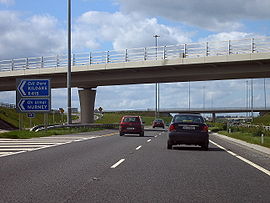
The M7 motorway is a motorway in Ireland
. The motorway runs continuously from the outskirts of Naas
in County Kildare
to Rossbrien on the outskirts of Limerick City. The M7 forms part of the Dublin to Limerick
N7 national primary road
. The section of the motorway bypassing Naas
, an 8 km stretch, was the first section of motorway to open in the Republic of Ireland, in 1983. Following substantial works to extend the M7 to Limerick
; by the end of 2010, the motorway replaced almost all of the single-carriageway N7 now designated R445. At 186 km, the M7 is the longest motorway in Ireland.
(junction 9 on the N7-M7 corridor), and proceeds southwestwards, bypassing Naas
, Newbridge
, Kildare
, Monasterevin
, Ballybrittas
, Portlaoise, Mountrath
, Borris-in-Ossory
, Roscrea
, Moneygall
, Toomevara
, Nenagh
and Annacotty
. As of December 2010, the M7 is approximately 186 km in length and ends at the Rosbrien interchange (junction 30) outside Limerick
. Here, the road connects to the Limerick Southern Ring Road - Phase 2 and continues as the N18. At junction 30 there is also a slip-road to the M20 Limerick - Cork/Kerry road. Along this section of the M7 there is a fly-over for the N24 Limerick to Waterford road at junction 29. Southwest of Portlaoise it forms an interchange with the M8 Dublin-Cork motorway
at junction 19 and at junction 11 there is an interchange with the M9 Dublin - Waterford motorway
(1983), Newbridge
(1993), Kildare
(December 2003), Monasterevin
(November 2004), Portlaoise (29 May 1997), Mountrath
and Borris-in-Ossory
(both 28 May 2010), Roscrea
, Moneygall
and Toomevara
(all 22 December 2010), Nenagh
(about 1996) and Birdhill
(28 September 2010) and the city of Limerick
(May 2004). Today, junctions provide access to all of these places. The old route has been re-classified as a regional road, the R445
. A restricted-access junction (junction 11) connects the M7 to the M9 motorway
to Waterford
, also allowing access from the M9 to eastbound carriageway of the M7.
Until summer 2006, junction numbers started at seven, although only the first five junctions were numbered. This junction numbering scheme was devised when it was believed that a motorway would be built from Naas to the yet-to-be-constructed junction 8 on the M50. While a motorway reservation still exists, it is now unlikely to be built, having being superseded by the widening of the N7 between Newlands Cross
and Naas to three lanes and the grade separation of this section. The junction numbers were renumbered to fit into this scheme in July–August 2006.
The construction of the Nenagh to Limerick section was slow and difficult. Work on this section began on December 7, 2006 and was initially due to be completed in May 2009. The total length of the scheme is 38 km (23.6 mi), of which 10 km (6.2 mi) was the upgrading of the single carriageway Nenagh bypass. The road opened in three stages. The Nenagh bypass re-opened to motorway standard on 17 December 2009 and the Nenagh to Birdhill section opened on 1 April 2010. Problems were encountered while constructing the road over two sections of deep bog at Annaholty and Drominboy near Birdhill and this delayed the opening of the Birdhill to Limerick section by over a year. Parts of the road collapsed over the two bogs and the sections were rebuilt and opened on 28 September 2010. This scheme was originally to be built as a high-quality dual carriageway
(HQDC), but it was re-designated motorway by Statutory Instrument on 17 July 2008.
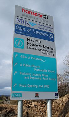
In June 2007, construction commenced on a 28 km (17.4 mi) section of the M7 motorway between Portlaoise and Castletown, which opened on May 28, 2010 and is subject to a toll north of the M7-M8 interchange. This M7 scheme runs between junctions 18 and 21 on the N7-M7 corridor and bypasses Borris-in-Ossory
and Mountrath
, this section includes a tie-in to the new 143 km M8
.
In March 2008, construction commenced on a 36 km section (22 miles) of the M7 route between Castletown, County Laois and Nenagh, tying into the Portlaoise-Castletown scheme mentioned above at the Borris-in-Ossory junction. It runs between junctions 21 and 24 on the N7-M7 corridor. This scheme was originally planned to proceed as a High Quality Dual Carriageway (HQDC), which would have seen it built to many of the same engineering standard as a motorway, with a design speed of 120 km/h, however a Statutory Instrument was passed on 17 July 2008, re-designating this and many other new HQDC schemes as motorway. Consequently, when this scheme was complete, it opened with full motorway regulations on 22 December 2010.
In May 2004 work was completed on phase 1 of the Limerick Southern Ring Road which consists of approximately 10 km (6.2 mi) of dual carriageway, and joins the M20 road to Cork and the N21 road to Kerry. Two grade separated junctions allow access to Limerick city at Annacotty via the R445 and at Ballysimon via the N24. The N20 Carew park link road was closed permanently to inbound traffic from both the M7 and M20 in June 2010 to facilitate phase 2 of the Limerick southern ring road project. The dual carriageway was redesignated as M7 in 2009. Phase 2 of the Limerick Southern Ring Road opened as part of the N18 and was completed in July 2010.

plans to construct on-line motorway service areas
at approximately 60-kilometre intervals along each of Ireland's interurban routes. Under this plan, the M7 will have two such areas: one will be located near Mountrath
(junction 15), while the other will be sited between Nenagh
and Roscrea
, near junction 23. As of January 2009, no details regarding the physical construction of the M7 service areas have been announced.
An independently owned service area, Junction 14 Mayfield, was opened in June 2011. Accessed from either direction, traffic must use the existing junction 14 slip roads with eastbound traffic then crossing to the south side of the motorway by bridge.
released the second tranche of potential motorway redesignations. These included parts of the present N7/M7 route.
The M7 was to end at junction 28, where it would have blended into the N7 southern ring road scheme. On the 10th July 2009, minsterial approval was given for 10 km of the Limerick southern-ring and the N7/N20 interchange (and all relevant slip-roads) to be redesignated to motorway status.)
If various other schemes on the N7 are to be redesignated motorway (e.g., the section from Dublin to Naas), the route could reach up to 220 km in length.
to D3M standard between the maudlin's interchange (J9) and the M7/M9 junction (J11).
The upgrade would include widening the existing carriageways to three lanes in each direction and modifying bridges and junctions on the route to accommodate the extra lane.
Republic of Ireland
Ireland , described as the Republic of Ireland , is a sovereign state in Europe occupying approximately five-sixths of the island of the same name. Its capital is Dublin. Ireland, which had a population of 4.58 million in 2011, is a constitutional republic governed as a parliamentary democracy,...
. The motorway runs continuously from the outskirts of Naas
Naas
Naas is the county town of County Kildare in Ireland. With a population of just over twenty thousand, it is also the largest town in the county. Naas is a major commuter suburb, with many people residing there and working in Dublin...
in County Kildare
County Kildare
County Kildare is a county in Ireland. It is part of the Mid-East Region and is also located in the province of Leinster. It is named after the town of Kildare. Kildare County Council is the local authority for the county...
to Rossbrien on the outskirts of Limerick City. The M7 forms part of the Dublin to Limerick
Limerick
Limerick is the third largest city in the Republic of Ireland, and the principal city of County Limerick and Ireland's Mid-West Region. It is the fifth most populous city in all of Ireland. When taking the extra-municipal suburbs into account, Limerick is the third largest conurbation in the...
N7 national primary road
National primary road
A national primary road is a road classification in the Republic of Ireland. National primary roads form the major routes between the major urban centres. There are over 2,700km of national primary roads. This category of road has the prefix "N" followed by one or two digits...
. The section of the motorway bypassing Naas
Naas
Naas is the county town of County Kildare in Ireland. With a population of just over twenty thousand, it is also the largest town in the county. Naas is a major commuter suburb, with many people residing there and working in Dublin...
, an 8 km stretch, was the first section of motorway to open in the Republic of Ireland, in 1983. Following substantial works to extend the M7 to Limerick
Limerick
Limerick is the third largest city in the Republic of Ireland, and the principal city of County Limerick and Ireland's Mid-West Region. It is the fifth most populous city in all of Ireland. When taking the extra-municipal suburbs into account, Limerick is the third largest conurbation in the...
; by the end of 2010, the motorway replaced almost all of the single-carriageway N7 now designated R445. At 186 km, the M7 is the longest motorway in Ireland.
Naas to Limerick
The N7 leads directly into the M7 motorway at the Maudlin's Interchange near NaasNaas
Naas is the county town of County Kildare in Ireland. With a population of just over twenty thousand, it is also the largest town in the county. Naas is a major commuter suburb, with many people residing there and working in Dublin...
(junction 9 on the N7-M7 corridor), and proceeds southwestwards, bypassing Naas
Naas
Naas is the county town of County Kildare in Ireland. With a population of just over twenty thousand, it is also the largest town in the county. Naas is a major commuter suburb, with many people residing there and working in Dublin...
, Newbridge
Newbridge, County Kildare
The earliest known mention of Newbridge was by traveller and bookseller John Dunton in 1698, though he does not refer to any settlement other than at Ballymany....
, Kildare
Kildare
-External links:*******...
, Monasterevin
Monasterevin
Situated 63 km from Dublin on the R445 road, Monasterevin has been relieved of much through traffic by the opening in 2004 of a new section of the M7 motorway bypassing the town on the N7 Dublin to Limerick route...
, Ballybrittas
Ballybrittas
Ballybrittas is a small village in the northeast of County Laois, Ireland situated on the R445 about 5 km SE of Monasterevin, County Kildare. Formerly on the N7 Dublin - Limerick road, the village is now bypassed by the M7 motorway. Ballybrittas is the current County Laois East Division Tidy...
, Portlaoise, Mountrath
Mountrath
Mountrath is a small town in County Laois, Ireland. Bypassed by the M7 motorway in 2010, the town lies on the R445 midway between Dublin and Limerick, exactly 96.5 km from both cities.In 2006 it had a population of 1,435...
, Borris-in-Ossory
Borris-in-Ossory
Borris-in-Ossory is a village in west County Laois, Ireland. Bypassed by the M7 motorway on 28 May, 2010, the village is situated on the R445 road close to the County Tipperary border between the towns of Mountrath and Roscrea.-Features:...
, Roscrea
Roscrea
Roscrea is a small heritage town in North Tipperary, Ireland. The town has a population of 4,910. Its main industries include meat processing and pharmaceuticals. It is a civil parish in the historical barony of Ikerrin...
, Moneygall
Moneygall
Moneygall is a small village on the border of counties Offaly and North Tipperary, in Ireland. It is situated on the R445 road between Dublin and Limerick. At the time of the 2006 census, the village had a population of 298. Moneygall has a Catholic church, five shops, a post office, a national...
, Toomevara
Toomevara
Toomevara, officially Toomyvara , is a village in North Tipperary, Ireland. The village is at the junction on the R445 where it meets the R499 regional road. The village was bypassed in December 2010 by the M7 Dublin - Limerick motorway. It is also a parish in the Roman Catholic Diocese of...
, Nenagh
Nenagh
Nenagh is the county town of North Tipperary in Ireland. It is the administrative centre of North Tipperary and in 2011 it had a recorded population of 7,995. It is a civil parish in the historical barony of Ormond Lower...
and Annacotty
Annacotty
Annacotty is a town on the outskirts of Limerick, Ireland, from the centre of the city. It is situated where the old N7 main road between Limerick and Dublin crosses the Mulkear River, upstream of where it flows into the River Shannon....
. As of December 2010, the M7 is approximately 186 km in length and ends at the Rosbrien interchange (junction 30) outside Limerick
Limerick
Limerick is the third largest city in the Republic of Ireland, and the principal city of County Limerick and Ireland's Mid-West Region. It is the fifth most populous city in all of Ireland. When taking the extra-municipal suburbs into account, Limerick is the third largest conurbation in the...
. Here, the road connects to the Limerick Southern Ring Road - Phase 2 and continues as the N18. At junction 30 there is also a slip-road to the M20 Limerick - Cork/Kerry road. Along this section of the M7 there is a fly-over for the N24 Limerick to Waterford road at junction 29. Southwest of Portlaoise it forms an interchange with the M8 Dublin-Cork motorway
M8 motorway (Ireland)
The M8 motorway is an inter-urban motorway in Ireland, which forms part of the road from the capital - Dublin - to Cork city. The 149 km motorway commences in the townland of Aghaboe, County Laois and runs through the counties of Kilkenny, North Tipperary, South Tipperary and Limerick,...
at junction 19 and at junction 11 there is an interchange with the M9 Dublin - Waterford motorway
M9 motorway (Ireland)
The M9 motorway is a motorway in Ireland linking the M7 at Kilcullen to Waterford. Opened in sections between 1994 and 2010, the final section opened on 9 September 2010....
History
The M7 was constructed in stages between 1983 and 2010 to replace the old national route which ran (in order from east to west) through the villages and towns of NaasNaas
Naas is the county town of County Kildare in Ireland. With a population of just over twenty thousand, it is also the largest town in the county. Naas is a major commuter suburb, with many people residing there and working in Dublin...
(1983), Newbridge
Newbridge, County Kildare
The earliest known mention of Newbridge was by traveller and bookseller John Dunton in 1698, though he does not refer to any settlement other than at Ballymany....
(1993), Kildare
Kildare
-External links:*******...
(December 2003), Monasterevin
Monasterevin
Situated 63 km from Dublin on the R445 road, Monasterevin has been relieved of much through traffic by the opening in 2004 of a new section of the M7 motorway bypassing the town on the N7 Dublin to Limerick route...
(November 2004), Portlaoise (29 May 1997), Mountrath
Mountrath
Mountrath is a small town in County Laois, Ireland. Bypassed by the M7 motorway in 2010, the town lies on the R445 midway between Dublin and Limerick, exactly 96.5 km from both cities.In 2006 it had a population of 1,435...
and Borris-in-Ossory
Borris-in-Ossory
Borris-in-Ossory is a village in west County Laois, Ireland. Bypassed by the M7 motorway on 28 May, 2010, the village is situated on the R445 road close to the County Tipperary border between the towns of Mountrath and Roscrea.-Features:...
(both 28 May 2010), Roscrea
Roscrea
Roscrea is a small heritage town in North Tipperary, Ireland. The town has a population of 4,910. Its main industries include meat processing and pharmaceuticals. It is a civil parish in the historical barony of Ikerrin...
, Moneygall
Moneygall
Moneygall is a small village on the border of counties Offaly and North Tipperary, in Ireland. It is situated on the R445 road between Dublin and Limerick. At the time of the 2006 census, the village had a population of 298. Moneygall has a Catholic church, five shops, a post office, a national...
and Toomevara
Toomevara
Toomevara, officially Toomyvara , is a village in North Tipperary, Ireland. The village is at the junction on the R445 where it meets the R499 regional road. The village was bypassed in December 2010 by the M7 Dublin - Limerick motorway. It is also a parish in the Roman Catholic Diocese of...
(all 22 December 2010), Nenagh
Nenagh
Nenagh is the county town of North Tipperary in Ireland. It is the administrative centre of North Tipperary and in 2011 it had a recorded population of 7,995. It is a civil parish in the historical barony of Ormond Lower...
(about 1996) and Birdhill
Birdhill
Birdhill is a village in North Tipperary, Ireland. It is in the barony of Owney and Arra and is part of the parish of Newport, Bridhill and Toor in the Roman Catholic Archdiocese of Cashel and Emly...
(28 September 2010) and the city of Limerick
Limerick
Limerick is the third largest city in the Republic of Ireland, and the principal city of County Limerick and Ireland's Mid-West Region. It is the fifth most populous city in all of Ireland. When taking the extra-municipal suburbs into account, Limerick is the third largest conurbation in the...
(May 2004). Today, junctions provide access to all of these places. The old route has been re-classified as a regional road, the R445
R445 road
The R445 road is a regional road in Ireland. The route is a non-motorway alternative route to the N7/M7 motorway between Dublin and Limerick. Indeed, much of the route comprises roads that were formerly part of the N7 between the cities, prior to motorway and other bypasses...
. A restricted-access junction (junction 11) connects the M7 to the M9 motorway
M9 motorway (Ireland)
The M9 motorway is a motorway in Ireland linking the M7 at Kilcullen to Waterford. Opened in sections between 1994 and 2010, the final section opened on 9 September 2010....
to Waterford
Waterford
Waterford is a city in the South-East Region of Ireland. It is the oldest city in the country and fifth largest by population. Waterford City Council is the local government authority for the city and its immediate hinterland...
, also allowing access from the M9 to eastbound carriageway of the M7.
Until summer 2006, junction numbers started at seven, although only the first five junctions were numbered. This junction numbering scheme was devised when it was believed that a motorway would be built from Naas to the yet-to-be-constructed junction 8 on the M50. While a motorway reservation still exists, it is now unlikely to be built, having being superseded by the widening of the N7 between Newlands Cross
Newlands Cross
Newlands Cross is a well-known crossroads in SW Dublin in the county of South Dublin.It is the point where the N7 National Route to the South West and Mid West crosses an orbital local route, the R113. Traditionally Newlands Cross was regarded as the place where Dublin City ended and the "country"...
and Naas to three lanes and the grade separation of this section. The junction numbers were renumbered to fit into this scheme in July–August 2006.
The construction of the Nenagh to Limerick section was slow and difficult. Work on this section began on December 7, 2006 and was initially due to be completed in May 2009. The total length of the scheme is 38 km (23.6 mi), of which 10 km (6.2 mi) was the upgrading of the single carriageway Nenagh bypass. The road opened in three stages. The Nenagh bypass re-opened to motorway standard on 17 December 2009 and the Nenagh to Birdhill section opened on 1 April 2010. Problems were encountered while constructing the road over two sections of deep bog at Annaholty and Drominboy near Birdhill and this delayed the opening of the Birdhill to Limerick section by over a year. Parts of the road collapsed over the two bogs and the sections were rebuilt and opened on 28 September 2010. This scheme was originally to be built as a high-quality dual carriageway
High-quality dual carriageway
A High-quality dual carriageway is a category of road in the Republic of Ireland. It is an all-purpose dual carriageway road type built to near motorway standards, but without motorway classification or motorway restrictions. High-quality dual carriageways have full grade-separated access and do...
(HQDC), but it was re-designated motorway by Statutory Instrument on 17 July 2008.
In June 2007, construction commenced on a 28 km (17.4 mi) section of the M7 motorway between Portlaoise and Castletown, which opened on May 28, 2010 and is subject to a toll north of the M7-M8 interchange. This M7 scheme runs between junctions 18 and 21 on the N7-M7 corridor and bypasses Borris-in-Ossory
Borris-in-Ossory
Borris-in-Ossory is a village in west County Laois, Ireland. Bypassed by the M7 motorway on 28 May, 2010, the village is situated on the R445 road close to the County Tipperary border between the towns of Mountrath and Roscrea.-Features:...
and Mountrath
Mountrath
Mountrath is a small town in County Laois, Ireland. Bypassed by the M7 motorway in 2010, the town lies on the R445 midway between Dublin and Limerick, exactly 96.5 km from both cities.In 2006 it had a population of 1,435...
, this section includes a tie-in to the new 143 km M8
M8 motorway (Ireland)
The M8 motorway is an inter-urban motorway in Ireland, which forms part of the road from the capital - Dublin - to Cork city. The 149 km motorway commences in the townland of Aghaboe, County Laois and runs through the counties of Kilkenny, North Tipperary, South Tipperary and Limerick,...
.
In March 2008, construction commenced on a 36 km section (22 miles) of the M7 route between Castletown, County Laois and Nenagh, tying into the Portlaoise-Castletown scheme mentioned above at the Borris-in-Ossory junction. It runs between junctions 21 and 24 on the N7-M7 corridor. This scheme was originally planned to proceed as a High Quality Dual Carriageway (HQDC), which would have seen it built to many of the same engineering standard as a motorway, with a design speed of 120 km/h, however a Statutory Instrument was passed on 17 July 2008, re-designating this and many other new HQDC schemes as motorway. Consequently, when this scheme was complete, it opened with full motorway regulations on 22 December 2010.
In May 2004 work was completed on phase 1 of the Limerick Southern Ring Road which consists of approximately 10 km (6.2 mi) of dual carriageway, and joins the M20 road to Cork and the N21 road to Kerry. Two grade separated junctions allow access to Limerick city at Annacotty via the R445 and at Ballysimon via the N24. The N20 Carew park link road was closed permanently to inbound traffic from both the M7 and M20 in June 2010 to facilitate phase 2 of the Limerick southern ring road project. The dual carriageway was redesignated as M7 in 2009. Phase 2 of the Limerick Southern Ring Road opened as part of the N18 and was completed in July 2010.
Junctions
| N7 Naas dual carriageway | |||
| Eastbound | Junction | Westbound | |
| M50 motorway M50 motorway (Ireland) The M50 motorway is a motorway in Ireland running in a C-shaped ring around the north-eastern, northern, western and southern sides of the capital city, Dublin. The northern end of the route is located at the entrance to the Dublin Port Tunnel. Anti-clockwise it heads northwest through the tunnel...  |
 |
M50 motorway M50 motorway (Ireland) The M50 motorway is a motorway in Ireland running in a C-shaped ring around the north-eastern, northern, western and southern sides of the capital city, Dublin. The northern end of the route is located at the entrance to the Dublin Port Tunnel. Anti-clockwise it heads northwest through the tunnel... |
|
| Newlands Cross Newlands Cross Newlands Cross is a well-known crossroads in SW Dublin in the county of South Dublin.It is the point where the N7 National Route to the South West and Mid West crosses an orbital local route, the R113. Traditionally Newlands Cross was regarded as the place where Dublin City ended and the "country"... (at grade); Belgard Road for Tallaght Tallaght Tallaght is the largest town, and county town, of South Dublin County, Ireland. The village area, dating from at least the 17th century, held one of the earliest settlements known in the southern part of the island, and one of medieval Ireland's more important monastic centres.Up to the 1960s... ; Fonthill Road for Clondalkin Clondalkin -Today:Modern Clondalkin is a busy satellite town of Dublin, with a population of 43,929 in 2006. Retail facilities include Tesco Ireland- and Dunnes Stores-led shopping centres, and Aldi and Lidl stores on the Fonthill Road and New Nangor Road respectively, and the village centre is a base for... (R113 R113 road The R113 road is a regional road in Ireland. Located in the east of Ireland at Dublin, it forms a semi-orbital route around the south of the city. As of 2007, clockwise, it starts at the N31 at Temple Hill in Blackrock and ends at a junction with the N4 at Palmerstown.The road is one of the... ) |
— | Newlands Cross Newlands Cross Newlands Cross is a well-known crossroads in SW Dublin in the county of South Dublin.It is the point where the N7 National Route to the South West and Mid West crosses an orbital local route, the R113. Traditionally Newlands Cross was regarded as the place where Dublin City ended and the "country"... (at grade); Belgard Road for Tallaght Tallaght Tallaght is the largest town, and county town, of South Dublin County, Ireland. The village area, dating from at least the 17th century, held one of the earliest settlements known in the southern part of the island, and one of medieval Ireland's more important monastic centres.Up to the 1960s... ; Fonthill Road for Clondalkin Clondalkin -Today:Modern Clondalkin is a busy satellite town of Dublin, with a population of 43,929 in 2006. Retail facilities include Tesco Ireland- and Dunnes Stores-led shopping centres, and Aldi and Lidl stores on the Fonthill Road and New Nangor Road respectively, and the village centre is a base for... (R113 R113 road The R113 road is a regional road in Ireland. Located in the east of Ireland at Dublin, it forms a semi-orbital route around the south of the city. As of 2007, clockwise, it starts at the N31 at Temple Hill in Blackrock and ends at a junction with the N4 at Palmerstown.The road is one of the... ) |
|
| Kingswood Interchange: Outer Ring Road (R136 R136 road The R136 road is a regional road in Ireland, located in the southwest of Dublin. Named the Outer Ring Road, the route , bypasses west of Clondalkin connecting the N4 to the Tallaght Bypass , crossing the N7... ) |
 |
Kingswood Interchange: Outer Ring Road (R136 R136 road The R136 road is a regional road in Ireland, located in the southwest of Dublin. Named the Outer Ring Road, the route , bypasses west of Clondalkin connecting the N4 to the Tallaght Bypass , crossing the N7... ) |
|
| Citywest Road (N82) | Citywest Road (N82) | ||
| Rathcoole Rathcoole, Dublin Rathcoole is a suburban village, south west of Tallaght, Ireland, in South Dublin County. It lies just off the N7 national primary road. It borders the nearby village of Saggart.- Geography :... |
Rathcoole Rathcoole, Dublin Rathcoole is a suburban village, south west of Tallaght, Ireland, in South Dublin County. It lies just off the N7 national primary road. It borders the nearby village of Saggart.- Geography :... |
||
| Steelstown Interchange: Steelstown |  |
Steelstown Interchange: Steelstown | |
| Castlewarden Interchange: Castlewarden (R445 R445 road The R445 road is a regional road in Ireland. The route is a non-motorway alternative route to the N7/M7 motorway between Dublin and Limerick. Indeed, much of the route comprises roads that were formerly part of the N7 between the cities, prior to motorway and other bypasses... ) |
 |
Castlewarden Interchange: Castlewarden (R445 R445 road The R445 road is a regional road in Ireland. The route is a non-motorway alternative route to the N7/M7 motorway between Dublin and Limerick. Indeed, much of the route comprises roads that were formerly part of the N7 between the cities, prior to motorway and other bypasses... ) |
|
| Kill Interchange: Kill Kill, County Kildare Kill is a village and parish in County Kildare, Ireland near the county's border with Dublin beside the N7. Its population of 2,510 makes it the 13th largest town in County Kildare. Kill is the birthpace of the Fenian John Devoy, sometimes regarded as the "grandfather of the modern Irish state"... (R445 R445 road The R445 road is a regional road in Ireland. The route is a non-motorway alternative route to the N7/M7 motorway between Dublin and Limerick. Indeed, much of the route comprises roads that were formerly part of the N7 between the cities, prior to motorway and other bypasses... ) |
 |
Kill Interchange: Kill Kill, County Kildare Kill is a village and parish in County Kildare, Ireland near the county's border with Dublin beside the N7. Its population of 2,510 makes it the 13th largest town in County Kildare. Kill is the birthpace of the Fenian John Devoy, sometimes regarded as the "grandfather of the modern Irish state"... (R445 R445 road The R445 road is a regional road in Ireland. The route is a non-motorway alternative route to the N7/M7 motorway between Dublin and Limerick. Indeed, much of the route comprises roads that were formerly part of the N7 between the cities, prior to motorway and other bypasses... ) |
|
| Johnstown Interchange: Johnstown Johnstown, County Kildare Johnstown , historically known as Freaghillan , is a village in County Kildare, Republic of Ireland. It is located 2 km north of Naas just off the N7 at junction 8. It is approximately 25 km from Dublin City Centre, and is a home for commuters working in Dublin and Naas... (R445 R445 road The R445 road is a regional road in Ireland. The route is a non-motorway alternative route to the N7/M7 motorway between Dublin and Limerick. Indeed, much of the route comprises roads that were formerly part of the N7 between the cities, prior to motorway and other bypasses... ) |
 |
Johnstown Interchange: Johnstown Johnstown, County Kildare Johnstown , historically known as Freaghillan , is a village in County Kildare, Republic of Ireland. It is located 2 km north of Naas just off the N7 at junction 8. It is approximately 25 km from Dublin City Centre, and is a home for commuters working in Dublin and Naas... (R445 R445 road The R445 road is a regional road in Ireland. The route is a non-motorway alternative route to the N7/M7 motorway between Dublin and Limerick. Indeed, much of the route comprises roads that were formerly part of the N7 between the cities, prior to motorway and other bypasses... ) |
|
| M7 motorway | |||
| Eastbound | Junction | Westbound | |
| Maudlins Interchange: Naas North, Sallins Sallins Sallins is a suburban town in County Kildare, Ireland, situated 3.5 km north of the town centre of Naas, from which it is separated by the M7 motorway. Sallins is the anglicised name of Na Solláin which means "The Willows".... (R445 R445 road The R445 road is a regional road in Ireland. The route is a non-motorway alternative route to the N7/M7 motorway between Dublin and Limerick. Indeed, much of the route comprises roads that were formerly part of the N7 between the cities, prior to motorway and other bypasses... ) |
|
Maudlins Interchange: Naas North, Sallins Sallins Sallins is a suburban town in County Kildare, Ireland, situated 3.5 km north of the town centre of Naas, from which it is separated by the M7 motorway. Sallins is the anglicised name of Na Solláin which means "The Willows".... (R445 R445 road The R445 road is a regional road in Ireland. The route is a non-motorway alternative route to the N7/M7 motorway between Dublin and Limerick. Indeed, much of the route comprises roads that were formerly part of the N7 between the cities, prior to motorway and other bypasses... ) |
|
| Naas South, Caragh Caragh Caragh or Carragh is a village in County Kildare, Ireland. It is located on the R409 regional road between the River Liffey and the Grand Canal approximately 4 km north-west of Naas... and Togher services and GreenIT Refurbished Laptops |
 |
Naas South, Caragh Caragh Caragh or Carragh is a village in County Kildare, Ireland. It is located on the R409 regional road between the River Liffey and the Grand Canal approximately 4 km north-west of Naas... and Togher services and GreenIT Refurbished Laptops |
|
| No access |  |
The SOUTH EAST (M9 M9 motorway (Ireland) The M9 motorway is a motorway in Ireland linking the M7 at Kilcullen to Waterford. Opened in sections between 1994 and 2010, the final section opened on 9 September 2010.... )- Kilkenny Kilkenny Kilkenny is a city and is the county town of the eponymous County Kilkenny in Ireland. It is situated on both banks of the River Nore in the province of Leinster, in the south-east of Ireland... , Carlow Carlow Carlow is the county town of County Carlow in Ireland. It is situated in the south-east of Ireland, 84 km from Dublin. County Carlow is the second smallest county in Ireland by area, however Carlow Town is the 14th largest urban area in Ireland by population according to the 2006 census. The... , Waterford Waterford Waterford is a city in the South-East Region of Ireland. It is the oldest city in the country and fifth largest by population. Waterford City Council is the local government authority for the city and its immediate hinterland... , Athy Athy The town developed from a 12th century Anglo-Norman settlement to an important British military outpost on the border of the Pale.The first town charter dates from the 16th century and the town hall was constructed in the early 18th century... |
|
| The Curragh, Newbridge Newbridge, County Kildare The earliest known mention of Newbridge was by traveller and bookseller John Dunton in 1698, though he does not refer to any settlement other than at Ballymany.... (R445 R445 road The R445 road is a regional road in Ireland. The route is a non-motorway alternative route to the N7/M7 motorway between Dublin and Limerick. Indeed, much of the route comprises roads that were formerly part of the N7 between the cities, prior to motorway and other bypasses... ) |
 |
The Curragh | |
| Kildare Kildare -External links:*******... , Nurney Nurney, County Kildare Nurney is a village in County Kildare, Ireland. It lies on the R415 regional road 8 km south of Kildare and is signposted from the M7 motorway at junction 13.The village has a church, a pub, a school, a shop, and two graveyards.-Demographics:... (R415 R415 road The R415 road is a regional road in Ireland, which runs north-south from its junction with the R403 in Allenwood to the R448 at Crookstown, passing through Kildare town, and crossing the N78 between Kilcullen and Athy. The route is entirely within County Kildare.The route is long.-References:* –... ) |
 |
Kildare Kildare -External links:*******... Nurney Nurney, County Kildare Nurney is a village in County Kildare, Ireland. It lies on the R415 regional road 8 km south of Kildare and is signposted from the M7 motorway at junction 13.The village has a church, a pub, a school, a shop, and two graveyards.-Demographics:... (R415 R415 road The R415 road is a regional road in Ireland, which runs north-south from its junction with the R403 in Allenwood to the R448 at Crookstown, passing through Kildare town, and crossing the N78 between Kilcullen and Athy. The route is entirely within County Kildare.The route is long.-References:* –... ) |
|
| Monasterevin Monasterevin Situated 63 km from Dublin on the R445 road, Monasterevin has been relieved of much through traffic by the opening in 2004 of a new section of the M7 motorway bypassing the town on the N7 Dublin to Limerick route... (R445 R445 road The R445 road is a regional road in Ireland. The route is a non-motorway alternative route to the N7/M7 motorway between Dublin and Limerick. Indeed, much of the route comprises roads that were formerly part of the N7 between the cities, prior to motorway and other bypasses... ), Junction 14 Mayfield service area. |
 |
Monasterevin Monasterevin Situated 63 km from Dublin on the R445 road, Monasterevin has been relieved of much through traffic by the opening in 2004 of a new section of the M7 motorway bypassing the town on the N7 Dublin to Limerick route... (R445 R445 road The R445 road is a regional road in Ireland. The route is a non-motorway alternative route to the N7/M7 motorway between Dublin and Limerick. Indeed, much of the route comprises roads that were formerly part of the N7 between the cities, prior to motorway and other bypasses... ), Junction 14 Mayfield service area. |
|
| Portarlington, Emo Emo, County Laois Emo is a village in County Laois, Ireland. It is located near Portlaoise on the R422 regional road just off the M7 Dublin–Limerick motorway.The late 18th century village of Emo originally sprang up around the gates of Emo Court... , The Heath The Heath The Heath GAA is a Gaelic Athletic Association gaelic football club in County Laois, Ireland.The club was founded in 1888. Originally the club was known as St. Patrick's... (R423 R423 road The R423 road is a regional road in Ireland linking Portarlington, County Laois to Mountrath, County Laois. It passes through the village of Mountmellick en route.The road is long.-References:* – Department of Transport... ) |
 |
Portarlington, Emo Emo, County Laois Emo is a village in County Laois, Ireland. It is located near Portlaoise on the R422 regional road just off the M7 Dublin–Limerick motorway.The late 18th century village of Emo originally sprang up around the gates of Emo Court... , The Heath The Heath The Heath GAA is a Gaelic Athletic Association gaelic football club in County Laois, Ireland.The club was founded in 1888. Originally the club was known as St. Patrick's... (R423 R423 road The R423 road is a regional road in Ireland linking Portarlington, County Laois to Mountrath, County Laois. It passes through the village of Mountmellick en route.The road is long.-References:* – Department of Transport... ) |
|
| Portlaoise (R445 R445 road The R445 road is a regional road in Ireland. The route is a non-motorway alternative route to the N7/M7 motorway between Dublin and Limerick. Indeed, much of the route comprises roads that were formerly part of the N7 between the cities, prior to motorway and other bypasses... ) (Carlow Carlow Carlow is the county town of County Carlow in Ireland. It is situated in the south-east of Ireland, 84 km from Dublin. County Carlow is the second smallest county in Ireland by area, however Carlow Town is the 14th largest urban area in Ireland by population according to the 2006 census. The... , Tullamore Tullamore Tullamore is a town in County Offaly, in the midlands of Ireland. It is Offaly's county town and the centre of the district.Tullamore is an important commercial and industrial centre in the region. Major international employers in the town include 'Tyco Healthcare' and 'Boston Scientific'. In... , N80 N80 road (Ireland) The N80 road is a national secondary road in Ireland that runs southeastwards from its junction with the N52 and R443 in the town of Tullamore in County Offaly, to the N11 at Ballynahallin, just north of Enniscorthy in County Wexford, a distance of 116 km... ) |
 |
Portlaoise (R445 R445 road The R445 road is a regional road in Ireland. The route is a non-motorway alternative route to the N7/M7 motorway between Dublin and Limerick. Indeed, much of the route comprises roads that were formerly part of the N7 between the cities, prior to motorway and other bypasses... ) (Carlow Carlow Carlow is the county town of County Carlow in Ireland. It is situated in the south-east of Ireland, 84 km from Dublin. County Carlow is the second smallest county in Ireland by area, however Carlow Town is the 14th largest urban area in Ireland by population according to the 2006 census. The... , Tullamore Tullamore Tullamore is a town in County Offaly, in the midlands of Ireland. It is Offaly's county town and the centre of the district.Tullamore is an important commercial and industrial centre in the region. Major international employers in the town include 'Tyco Healthcare' and 'Boston Scientific'. In... , N80 N80 road (Ireland) The N80 road is a national secondary road in Ireland that runs southeastwards from its junction with the N52 and R443 in the town of Tullamore in County Offaly, to the N11 at Ballynahallin, just north of Enniscorthy in County Wexford, a distance of 116 km... ) |
|
| Abbeyleix Abbeyleix Abbeyleix is a town in County Laois, Ireland about from Portlaoise and located on the N77 national secondary route. Formerly the N8 National Primary Route ran through the centre of the town, making Abbeyleix an infamous bottleneck on the Dublin-Cork corridor with up to 15,000 vehicles passing... (N77 N77 road (Ireland) The N77 road is a national secondary road in Ireland. It links the N10 national primary on the ring road south of Kilkenny, County Kilkenny to the N8 national primary road at Durrow in County Laois.-Upgrades and Extensions:... ); Portlaoise (R423 R423 road The R423 road is a regional road in Ireland linking Portarlington, County Laois to Mountrath, County Laois. It passes through the village of Mountmellick en route.The road is long.-References:* – Department of Transport... ) |
 |
Abbeyleix Abbeyleix Abbeyleix is a town in County Laois, Ireland about from Portlaoise and located on the N77 national secondary route. Formerly the N8 National Primary Route ran through the centre of the town, making Abbeyleix an infamous bottleneck on the Dublin-Cork corridor with up to 15,000 vehicles passing... (N77 N77 road (Ireland) The N77 road is a national secondary road in Ireland. It links the N10 national primary on the ring road south of Kilkenny, County Kilkenny to the N8 national primary road at Durrow in County Laois.-Upgrades and Extensions:... ); Portlaoise (R423 R423 road The R423 road is a regional road in Ireland linking Portarlington, County Laois to Mountrath, County Laois. It passes through the village of Mountmellick en route.The road is long.-References:* – Department of Transport... ) |
|
| Portlaoise (R445 R445 road The R445 road is a regional road in Ireland. The route is a non-motorway alternative route to the N7/M7 motorway between Dublin and Limerick. Indeed, much of the route comprises roads that were formerly part of the N7 between the cities, prior to motorway and other bypasses... ) |
 |
Mountrath, Castletown, Tullamore (R445 R445 road The R445 road is a regional road in Ireland. The route is a non-motorway alternative route to the N7/M7 motorway between Dublin and Limerick. Indeed, much of the route comprises roads that were formerly part of the N7 between the cities, prior to motorway and other bypasses... ) |
|
| No access |  |
The SOUTH (M8 M8 motorway (Ireland) The M8 motorway is an inter-urban motorway in Ireland, which forms part of the road from the capital - Dublin - to Cork city. The 149 km motorway commences in the townland of Aghaboe, County Laois and runs through the counties of Kilkenny, North Tipperary, South Tipperary and Limerick,... ) - CorkCork (city) Cork is the second largest city in the Republic of Ireland and the island of Ireland's third most populous city. It is the principal city and administrative centre of County Cork and the largest city in the province of Munster. Cork has a population of 119,418, while the addition of the suburban... , Cashel Cashel, County Tipperary Cashel is a town in South Tipperary in Ireland. Its population was 2936 at the 2006 census. The town gives its name to the ecclesiastical province of Cashel. Additionally, the cathedra of the Roman Catholic Archdiocese of Cashel and Emly was originally in the town prior to the English Reformation.... , Fermoy Fermoy Fermoy is a town in County Cork, Ireland. It is situated on the River Blackwater in the south of Ireland. Its population is some 5,800 inhabitants, environs included .... |
|
| Borris-in-Ossory Borris-in-Ossory Borris-in-Ossory is a village in west County Laois, Ireland. Bypassed by the M7 motorway on 28 May, 2010, the village is situated on the R445 road close to the County Tipperary border between the towns of Mountrath and Roscrea.-Features:... |
 |
Borris-in-Ossory Borris-in-Ossory Borris-in-Ossory is a village in west County Laois, Ireland. Bypassed by the M7 motorway on 28 May, 2010, the village is situated on the R445 road close to the County Tipperary border between the towns of Mountrath and Roscrea.-Features:... |
|
| Roscrea Roscrea Roscrea is a small heritage town in North Tipperary, Ireland. The town has a population of 4,910. Its main industries include meat processing and pharmaceuticals. It is a civil parish in the historical barony of Ikerrin... Templemore Templemore Templemore is a town in North Tipperary, Ireland. It is a civil parish in the historical barony of Eliogarty. It is part of the Roman Catholic parish of Templemore, Clonmore and Killea.... (N62 N62 road (Ireland) The N62 road is a national secondary road in Ireland. It links the M6 motorway east of Athlone, County Westmeath with junction 6 of the M8 motorway south-east of Thurles in County Tipperary... ) |
 |
Roscrea Roscrea Roscrea is a small heritage town in North Tipperary, Ireland. The town has a population of 4,910. Its main industries include meat processing and pharmaceuticals. It is a civil parish in the historical barony of Ikerrin... Templemore Templemore Templemore is a town in North Tipperary, Ireland. It is a civil parish in the historical barony of Eliogarty. It is part of the Roman Catholic parish of Templemore, Clonmore and Killea.... (N62 N62 road (Ireland) The N62 road is a national secondary road in Ireland. It links the M6 motorway east of Athlone, County Westmeath with junction 6 of the M8 motorway south-east of Thurles in County Tipperary... ) |
|
| Moneygall Moneygall Moneygall is a small village on the border of counties Offaly and North Tipperary, in Ireland. It is situated on the R445 road between Dublin and Limerick. At the time of the 2006 census, the village had a population of 298. Moneygall has a Catholic church, five shops, a post office, a national... |
 |
Moneygall Moneygall Moneygall is a small village on the border of counties Offaly and North Tipperary, in Ireland. It is situated on the R445 road between Dublin and Limerick. At the time of the 2006 census, the village had a population of 298. Moneygall has a Catholic church, five shops, a post office, a national... , Cloghjordan |
|
| Toomevara Toomevara Toomevara, officially Toomyvara , is a village in North Tipperary, Ireland. The village is at the junction on the R445 where it meets the R499 regional road. The village was bypassed in December 2010 by the M7 Dublin - Limerick motorway. It is also a parish in the Roman Catholic Diocese of... , Nenagh Nenagh Nenagh is the county town of North Tipperary in Ireland. It is the administrative centre of North Tipperary and in 2011 it had a recorded population of 7,995. It is a civil parish in the historical barony of Ormond Lower... (R445 R445 road The R445 road is a regional road in Ireland. The route is a non-motorway alternative route to the N7/M7 motorway between Dublin and Limerick. Indeed, much of the route comprises roads that were formerly part of the N7 between the cities, prior to motorway and other bypasses... ) |
 |
Toomevara Toomevara Toomevara, officially Toomyvara , is a village in North Tipperary, Ireland. The village is at the junction on the R445 where it meets the R499 regional road. The village was bypassed in December 2010 by the M7 Dublin - Limerick motorway. It is also a parish in the Roman Catholic Diocese of... , Nenagh Nenagh Nenagh is the county town of North Tipperary in Ireland. It is the administrative centre of North Tipperary and in 2011 it had a recorded population of 7,995. It is a civil parish in the historical barony of Ormond Lower... (R445 R445 road The R445 road is a regional road in Ireland. The route is a non-motorway alternative route to the N7/M7 motorway between Dublin and Limerick. Indeed, much of the route comprises roads that were formerly part of the N7 between the cities, prior to motorway and other bypasses... ) |
|
| Knockalton, Nenagh Nenagh Nenagh is the county town of North Tipperary in Ireland. It is the administrative centre of North Tipperary and in 2011 it had a recorded population of 7,995. It is a civil parish in the historical barony of Ormond Lower... , Thurles Thurles Thurles is a town situated in North Tipperary, Ireland. It is a civil parish in the historical barony of Eliogarty and is also an ecclesiastical parish in the Roman Catholic Archdiocese of Cashel and Emly... (R498 R498 road The R498 is a regional road in North Tipperary linking Nenagh, via Borrisoleigh and Bouladuff to Thurles. The road is approximately long.-R498-N62 Link Road:A road to link the R498 with the N62 is currently in construction... ) |
 |
Knockalton, Nenagh Nenagh Nenagh is the county town of North Tipperary in Ireland. It is the administrative centre of North Tipperary and in 2011 it had a recorded population of 7,995. It is a civil parish in the historical barony of Ormond Lower... , Thurles Thurles Thurles is a town situated in North Tipperary, Ireland. It is a civil parish in the historical barony of Eliogarty and is also an ecclesiastical parish in the Roman Catholic Archdiocese of Cashel and Emly... (R498 R498 road The R498 is a regional road in North Tipperary linking Nenagh, via Borrisoleigh and Bouladuff to Thurles. The road is approximately long.-R498-N62 Link Road:A road to link the R498 with the N62 is currently in construction... ) |
|
| Carrigatoher, Nenagh Nenagh Nenagh is the county town of North Tipperary in Ireland. It is the administrative centre of North Tipperary and in 2011 it had a recorded population of 7,995. It is a civil parish in the historical barony of Ormond Lower... (R445 R445 road The R445 road is a regional road in Ireland. The route is a non-motorway alternative route to the N7/M7 motorway between Dublin and Limerick. Indeed, much of the route comprises roads that were formerly part of the N7 between the cities, prior to motorway and other bypasses... ), (N52) |
 |
Carrigatoher, Nenagh Nenagh Nenagh is the county town of North Tipperary in Ireland. It is the administrative centre of North Tipperary and in 2011 it had a recorded population of 7,995. It is a civil parish in the historical barony of Ormond Lower... (R445 R445 road The R445 road is a regional road in Ireland. The route is a non-motorway alternative route to the N7/M7 motorway between Dublin and Limerick. Indeed, much of the route comprises roads that were formerly part of the N7 between the cities, prior to motorway and other bypasses... ), (N52) |
|
| Birdhill Birdhill Birdhill is a village in North Tipperary, Ireland. It is in the barony of Owney and Arra and is part of the parish of Newport, Bridhill and Toor in the Roman Catholic Archdiocese of Cashel and Emly... , Killaloe Killaloe Killaloe may refer to:*Killaloe, County Clare, Ireland*Diocese of Killaloe, County Clare, Ireland*Roman Catholic Diocese of Killaloe, County Clare, Ireland*Killaloe, Ontario, Canada*Killaloe March, Regimental music of the Royal Irish Regiment... , Ballina Ballina, County Mayo Ballina is a large town in north County Mayo in Ireland. It lies at the mouth of the River Moy near Killala Bay, in the Moy valley and Parish of Kilmoremoy, with the Ox Mountain range to the east and the Nephin Beg mountains to the west... (R494 R494 road The R494 road is a regional road in Ireland which runs southwest-northeast from the N7 at Birdhill, County Tipperary to the N52 at Nenagh - all in County Tipperary... ) |
 |
Birdhill Birdhill Birdhill is a village in North Tipperary, Ireland. It is in the barony of Owney and Arra and is part of the parish of Newport, Bridhill and Toor in the Roman Catholic Archdiocese of Cashel and Emly... , Killaloe Killaloe Killaloe may refer to:*Killaloe, County Clare, Ireland*Diocese of Killaloe, County Clare, Ireland*Roman Catholic Diocese of Killaloe, County Clare, Ireland*Killaloe, Ontario, Canada*Killaloe March, Regimental music of the Royal Irish Regiment... , Ballina Ballina, County Mayo Ballina is a large town in north County Mayo in Ireland. It lies at the mouth of the River Moy near Killala Bay, in the Moy valley and Parish of Kilmoremoy, with the Ox Mountain range to the east and the Nephin Beg mountains to the west... (R494 R494 road The R494 road is a regional road in Ireland which runs southwest-northeast from the N7 at Birdhill, County Tipperary to the N52 at Nenagh - all in County Tipperary... ) |
|
| Annacotty Annacotty Annacotty is a town on the outskirts of Limerick, Ireland, from the centre of the city. It is situated where the old N7 main road between Limerick and Dublin crosses the Mulkear River, upstream of where it flows into the River Shannon.... , Limerick (east) Limerick Limerick is the third largest city in the Republic of Ireland, and the principal city of County Limerick and Ireland's Mid-West Region. It is the fifth most populous city in all of Ireland. When taking the extra-municipal suburbs into account, Limerick is the third largest conurbation in the... (R445 R445 road The R445 road is a regional road in Ireland. The route is a non-motorway alternative route to the N7/M7 motorway between Dublin and Limerick. Indeed, much of the route comprises roads that were formerly part of the N7 between the cities, prior to motorway and other bypasses... ), Newport Newport, County Tipperary Newport is a town in North Tipperary in Ireland. It is part of the parish of Newport, Bridhill and Toor which is in the Roman Catholic Archdiocese of Cashel and Emly. It is in the barony of Owney and Arra.-Location:... (R503 R503 road The R503 road is a regional road in Ireland which runs east-west from Thurles, County Tipperary to the N7 west of Limerick City.As of March 2009 much of the road is in a very poor condition.The entire route is in County Tipperary and is long.... ) |
 |
Annacotty Annacotty Annacotty is a town on the outskirts of Limerick, Ireland, from the centre of the city. It is situated where the old N7 main road between Limerick and Dublin crosses the Mulkear River, upstream of where it flows into the River Shannon.... , Limerick (east) Limerick Limerick is the third largest city in the Republic of Ireland, and the principal city of County Limerick and Ireland's Mid-West Region. It is the fifth most populous city in all of Ireland. When taking the extra-municipal suburbs into account, Limerick is the third largest conurbation in the... (R445 R445 road The R445 road is a regional road in Ireland. The route is a non-motorway alternative route to the N7/M7 motorway between Dublin and Limerick. Indeed, much of the route comprises roads that were formerly part of the N7 between the cities, prior to motorway and other bypasses... ), Newport Newport, County Tipperary Newport is a town in North Tipperary in Ireland. It is part of the parish of Newport, Bridhill and Toor which is in the Roman Catholic Archdiocese of Cashel and Emly. It is in the barony of Owney and Arra.-Location:... (R503 R503 road The R503 road is a regional road in Ireland which runs east-west from Thurles, County Tipperary to the N7 west of Limerick City.As of March 2009 much of the road is in a very poor condition.The entire route is in County Tipperary and is long.... ) |
|
| Ballysimon Interchange, Limerick (centre) Limerick Limerick is the third largest city in the Republic of Ireland, and the principal city of County Limerick and Ireland's Mid-West Region. It is the fifth most populous city in all of Ireland. When taking the extra-municipal suburbs into account, Limerick is the third largest conurbation in the... (R527), Waterford Waterford Waterford is a city in the South-East Region of Ireland. It is the oldest city in the country and fifth largest by population. Waterford City Council is the local government authority for the city and its immediate hinterland... (N24) |
 |
Ballysimon Interchange, Limerick (centre) Limerick Limerick is the third largest city in the Republic of Ireland, and the principal city of County Limerick and Ireland's Mid-West Region. It is the fifth most populous city in all of Ireland. When taking the extra-municipal suburbs into account, Limerick is the third largest conurbation in the... (R527), Waterford Waterford Waterford is a city in the South-East Region of Ireland. It is the oldest city in the country and fifth largest by population. Waterford City Council is the local government authority for the city and its immediate hinterland... (N24) |
|
| Rossbrien Interchange, Limerick (city centre) Limerick Limerick is the third largest city in the Republic of Ireland, and the principal city of County Limerick and Ireland's Mid-West Region. It is the fifth most populous city in all of Ireland. When taking the extra-municipal suburbs into account, Limerick is the third largest conurbation in the... (R509 R509 road The R509 road, following part of the Childers Road , is a regional road in Ireland, running through the southeastern side of Limerick City... ), Cork Cork (city) Cork is the second largest city in the Republic of Ireland and the island of Ireland's third most populous city. It is the principal city and administrative centre of County Cork and the largest city in the province of Munster. Cork has a population of 119,418, while the addition of the suburban... (M20 ) |
 |
Rossbrien Interchange, Cork Cork (city) Cork is the second largest city in the Republic of Ireland and the island of Ireland's third most populous city. It is the principal city and administrative centre of County Cork and the largest city in the province of Munster. Cork has a population of 119,418, while the addition of the suburban... (M20 ) |
|
| Continues as N18 dual carriageway. | |||
Motorway service areas
The National Roads AuthorityNational Roads Authority
The National Roads Authority is a state body in the Republic of Ireland, responsible for the national road network. The NRA was established as part of the Roads Act 1993 and commenced operations on 23 December 1993 in accordance with S.I. 407 of 1993.County councils remain responsible for local...
plans to construct on-line motorway service areas
Rest area
A rest area, travel plaza, rest stop, or service area is a public facility, located next to a large thoroughfare such as a highway, expressway, or freeway at which drivers and passengers can rest, eat, or refuel without exiting on to secondary roads...
at approximately 60-kilometre intervals along each of Ireland's interurban routes. Under this plan, the M7 will have two such areas: one will be located near Mountrath
Mountrath
Mountrath is a small town in County Laois, Ireland. Bypassed by the M7 motorway in 2010, the town lies on the R445 midway between Dublin and Limerick, exactly 96.5 km from both cities.In 2006 it had a population of 1,435...
(junction 15), while the other will be sited between Nenagh
Nenagh
Nenagh is the county town of North Tipperary in Ireland. It is the administrative centre of North Tipperary and in 2011 it had a recorded population of 7,995. It is a civil parish in the historical barony of Ormond Lower...
and Roscrea
Roscrea
Roscrea is a small heritage town in North Tipperary, Ireland. The town has a population of 4,910. Its main industries include meat processing and pharmaceuticals. It is a civil parish in the historical barony of Ikerrin...
, near junction 23. As of January 2009, no details regarding the physical construction of the M7 service areas have been announced.
An independently owned service area, Junction 14 Mayfield, was opened in June 2011. Accessed from either direction, traffic must use the existing junction 14 slip roads with eastbound traffic then crossing to the south side of the motorway by bridge.
Roadside Art on M7
Roadside art is funded under the Percentage For Arts Scheme where 1% of the scheme budget is allocated to roadside art with a cap of €63,000. The local authorities decide on a theme and are responsible for commissioning the work, usually by open competition. There are several examples along the M7- Perpetual Motion, a large sphere with road markings situated where the N7 becomes the M7 at Naas. Created by Remco de Fouw in collaboration with Rachel JoyntRachel JoyntRachel Joynt is an Irish sculptor who has created some prominent Irish public art. She graduated from the National College of Art and Design in Dublin in 1989 with a degree in sculpture....
in 1995. RTE radio show about Perpetual Motion - Race of The Black Pig on the KildareKildare-External links:*******...
bypass. Artist Dan George created (2003) this 0.4 km long installation in three segments, East, Central and West groups. - The Hitchhiker on the MonasterevinMonasterevinSituated 63 km from Dublin on the R445 road, Monasterevin has been relieved of much through traffic by the opening in 2004 of a new section of the M7 motorway bypassing the town on the N7 Dublin to Limerick route...
bypass. Artist Willie Malone created this phosphor bronze installation (2005) to represent the wheel. Jointly commissioned by KildareCounty KildareCounty Kildare is a county in Ireland. It is part of the Mid-East Region and is also located in the province of Leinster. It is named after the town of Kildare. Kildare County Council is the local authority for the county...
and LaoisCounty LaoisCounty Laois is a county in Ireland. It is part of the Midlands Region and is also located in the province of Leinster. It was formerly known as Queen's County until the establishment of the Irish Free State in 1922. The county's name was formerly spelt as Laoighis and Leix. Laois County Council...
County Councils.. In March 2011 The Hitchhiker was removed from the side of the motorway by persons unknown. - Doon a two-part earthwork with stainless steel superstructure located on the Portlaoise bypass. Viewed from the air the implication is that the earthwork ring stretches across the motorway. Artists Robert McColgan and Irene Benner.
- Architects of the Land, limestone figures of a Man and a Bull, one each side of M7 NenaghNenaghNenagh is the county town of North Tipperary in Ireland. It is the administrative centre of North Tipperary and in 2011 it had a recorded population of 7,995. It is a civil parish in the historical barony of Ormond Lower...
Bypass. Artist Colin Grehan created the sculpture in 2001 from two massive limestone blocks. The mans legs merge into plough shears, his pose designed to indicate an imaginary link to the bull across the carriageways.
Future
Motorway redesignations affecting the M7
On 30 September 2008, the Irish National Roads AuthorityNational Roads Authority
The National Roads Authority is a state body in the Republic of Ireland, responsible for the national road network. The NRA was established as part of the Roads Act 1993 and commenced operations on 23 December 1993 in accordance with S.I. 407 of 1993.County councils remain responsible for local...
released the second tranche of potential motorway redesignations. These included parts of the present N7/M7 route.
The M7 was to end at junction 28, where it would have blended into the N7 southern ring road scheme. On the 10th July 2009, minsterial approval was given for 10 km of the Limerick southern-ring and the N7/N20 interchange (and all relevant slip-roads) to be redesignated to motorway status.)
If various other schemes on the N7 are to be redesignated motorway (e.g., the section from Dublin to Naas), the route could reach up to 220 km in length.
Widening
It is proposed to widen 13 km of the existing two-lane dual carriagewayDual carriageway
A dual carriageway is a class of highway with two carriageways for traffic travelling in opposite directions separated by a central reservation...
to D3M standard between the maudlin's interchange (J9) and the M7/M9 junction (J11).
The upgrade would include widening the existing carriageways to three lanes in each direction and modifying bridges and junctions on the route to accommodate the extra lane.
See also
- Roads in IrelandRoads in IrelandThe island of Ireland, comprising Northern Ireland and the Republic of Ireland, has an extensive network of tens of thousands of kilometres of public roads, usually surfaced. These roads have been developed and modernised over centuries, from trackways suitable only for walkers and horses, to...
- Motorways in Ireland
- National primary roadNational primary roadA national primary road is a road classification in the Republic of Ireland. National primary roads form the major routes between the major urban centres. There are over 2,700km of national primary roads. This category of road has the prefix "N" followed by one or two digits...
- National secondary roadNational secondary roadA national secondary road is a category of road in Ireland. These roads form an important part of the national route network, but are secondary to the main arterial routes which are classified as national primary roads. National secondary roads are designated with route numbers higher than those...
- Regional roadRegional roadA regional road in Ireland is a class of road not forming a major route , but nevertheless forming a link in the national route network. There are over 11,600 kilometres of regional roads. Regional roads are numbered with three digit route numbers, prefixed by "R" A regional road in Ireland is a...
External links
- Roads Act 1993 (Classification of National Roads) Order 2006 – Department of TransportDepartment of Transport (Ireland)The Department of Transport, Tourism and Sport is a department of the Government of Ireland that is responsible for transport policy and overseeing transport services and infrastructure. The Department is led by the Minister for Transport, Tourism and Sport who is assisted by two Ministers of State...
- M7 Portlaoise to Castletown scheme website