
2005 Pacific typhoon season
Encyclopedia
The 2005 Pacific typhoon season had no official bounds; it ran year-round in 2005, but most tropical cyclones tend to form in the northwestern Pacific Ocean between May and November. These dates conventionally delimit the period of each year when most tropical cyclones form in the northwestern Pacific Ocean.
The scope of this article is limited to the Pacific Ocean, north of the equator and west of the international date line
. Storms that form east of the date line and north of the equator are called hurricanes; see 2005 Pacific hurricane season
. Tropical storms that form in the West Pacific basin are assigned a name by the Japan Meteorological Agency
. Tropical depressions in this basin have the "W" suffix added to their number. Tropical depressions that enter or form in the Philippine area of responsibility
are assigned a name by the Philippine Atmospheric, Geophysical and Astronomical Services Administration
or PAGASA. This can often result in the same storm having two names.
This season, the circular list of 140 names, in use since January 1, 2000, was recycled following the formation of Typhoons Saola; the final name on the list, and Damrey; the first name on the list.
. This allowed deep convection
to develop over a broad low-level circulation
. The next day, the Joint Typhoon Warning Center
(JTWC) issued a Tropical Cyclone Formation Alert
(TCFA) as the system continued to develop. Later that day, they issued their first advisory on Tropical Depression 01W while the storm was located about 215 km (130 mi) southwest of Chuuk
. Several hours later, the Japan Meteorological Agency
(JMA) also designated the system as a tropical depression. Early on January 15, the JTWC upgraded 01W to a tropical storm as the system turned towards the north. The northward movement was the result of the system traveling along the edge of a low to mid-level ridge
located to the east. About 12 hours later, the JMA upgraded the depression to a tropical storm and gave it the name Kulap; which was contributed by Thailand
and is the Thai word for rose
. Kulap gradually intensified over the next two days, reaching reaching its peak intensity with winds of 95 km/h (60 mph 10-minute winds) around 1800 UTC
on January 17, making it a severe tropical storm according to the JMA. However, at the same time the JMA assessed Kulap to have reached its peak intensity, the JTWC classified it as a minimal typhoon with winds of 120 km/h (75 mph 1-minute winds). Shortly after reaching its peak intensity, the storm began to undergo an extratropical transition
and weaken. Late on January 18, the JTWC issued their final advisory on Kulap despite the storm remaining tropical. The JMA considered Kulap to have been a tropical storm until early the next day. The storm dissipated as a weak extratropical system around 1200 UTC on January 19. Between January 13 and 14, the storm produced heavy rains over the island of Chuuk. Upwards of 300 mm (12 in) of rain fell during the two day span, of which 166.6 mm (6.5 in) fell in 24 hours.
May 31). Nesat is a Cambodian word for fisherman. On the evening of June 1, it strengthened into Typhoon Nesat. On June 2, it entered the Philippine area of responsibility and was assigned the name Dante for Philippine warnings. Typhoon Nesat (Dante) quickly grew to a Category 4 storm as it approached the Philippines, but it curved away to the northeast and did not pose a threat to land. Waxing and waning in strength it eventually became extratropical southeast of Honshū, Japan
at tropical storm strength on the morning of June 10 at 0000 UTC (0900 JST
).
and Japan's Sakishima Islands
. Haitang strengthened into a Category 5 super typhoon. On July 17 it weakened to a Category 3 as it continued west, sparing Sakishima a direct hit but aiming directly for Taiwan. Typhoon Haitang made landfall near Hualien, Taiwan
at 0000 UTC (0800 HKT
) on the morning of July 18. Taking a full day to cross the island and over the interior mountains, it caused flash floods and landslides killing four people. Weakening to a tropical storm as it entered the South China Sea, it reorganized into a minimal typhoon as it approached the southeast China coast. Haitang made landfall for the second time near Wenzhou
China on July 19 at 1200 UTC (2000 HKT). Moving inland, it rapidly lost its strength and dissipated. PAGASA stopped issuing advisories for the storm near Jiangxi
on July 20.
on the morning of July 20. Nalgae is a Korean word for wing. Nalgae did not reach typhoon intensity or threaten land. It turned to the north and then east, avoiding Japan.
on July 27.
. The storm moved west towards Hainan
. Tropical Storm Washi made its first landfall near Xinglong, Hainan. After re-entering the Gulf of Tonkin, the storm made its final landfall near Nam Dinh, Vietnam
.
and Okinawa with the center of the storm passing over the Yaeyama Islands
of Japan on the evening of August 4. The storm made landfall near Zhejiang
, Anhui
, Jiangsu
and Shanghai on mainland China
on the morning of August 6 with maximum sustained winds of 145 km/h (90 mph). The storm rapidly dissipated inland over China but remnants brought heavy rain inland west of Shanghai.
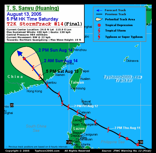
 Typhoon Sanvu (Huaning) formed as a tropical depression on the morning of August 10 at 0000 UTC (0800 PHT
) 320 nautical miles east-northeast of Borongan on Samar Island
inside the Philippine area of responsibility. PAGASA assigns names to Tropical Depressions because they often bring heavy rains and mudslides to the Philippines. Storm was named Tropical Depression Huaning for Philippine warnings but within 24 hours received the more recognized name Sanvu when it became a Tropical Storm. Sanvu is a Chinese name for coral. Tropical Storm Sanvu (Huaning) passed over a peninsula in Cagayan
province on the island of Luzon
early on the morning of August 12. It was upgraded to a typhoon before making landfall in China the next day on August 13. Sanvu (Huaning) rapidly dissipated after moving inland on August 14.
Sanvu was the first typhoon that necessitated a tropical cyclone signal for Hong Kong.
. Mawar is a Malay word for a rose. The storm intensified rapidly in two days to a Category 4 Super Typhoon but weakened as it approached Japan. Mawar made landfall on Honshū
as a Category 2 Typhoon on August 25 at 1800 UTC (August 26 0300 JST) with winds of 95 mph (152 km/h). After moving inland to the northwest it was downgraded to a Category 1 before entering the Pacific Ocean. It was downgraded to a Tropical Storm on August 26 and became extratropical on August 27. At least two people were killed by Mawar.
) 190 nautical miles (350 kilometers) southwest of Marcus Island, Japan. It reached Tropical Storm strength the next day and was named Guchol, a Yapese name for the spice turmeric
. Guchol curved to the northwest and never threatened land. It became extratropical August 25 at 0000 UTC (0900 JST) 735 nautical miles (1,285 km) east-southeast of Nakashibetsu, Hokkaidō
, Japan.
. Within 24 hours it was upgraded to Tropical Storm Talim and the next day became a Typhoon. Talim is a Philippine name for a knife or sharp cutting edge. Typhoon Talim was assigned the name Typhoon Isang for Philippine warnings when it entered the Philippine area of responsibility on August 29. Typhoon Talim (Isang) made landfall at 1800 UTC August 31 (0200 PHT
September 1) as a Category 3 storm. Talim dissipated over southeastern China on September 1. Typhoon Talim left at least 110 people dead and 23 missing in Fujian
, Zhejiang
, Jiangxi
& Anhui
provinces, with at least 40 people dead in the latter province due to landslides. It also left 7 dead in Taiwan. http://news.yahoo.com/news?tmpl=story&u=/afp/20050903/wl_afp/chinaweather_050903153304
. 18 hours later it was upgraded to Tropical Storm Nabi. Nabi is a Korean word for a butterfly
. It strengthened into a Typhoon on August 30 and passed near the islands of Saipan
and Guam
on August 31.After passing near the Marianas Islands, the storm continued to strengthen until reaching Category 5 intensity on September 1. Typhoon Nabi was assigned the name Jolina for Philippine warnings when it entered the Philippine area of responsibility on September 3. Typhoon Nabi (Jolina) passed to the east of the island of Okinawa, Japan, and made landfall in the Kagoshima Prefecture
of Japan on September 6 as a Category 2 storm. It dissipated shortly after that.
Twenty-one deaths have been reported in Japan. On September 8, five people were missing in South Korea and fifty in Japan as a result of the storm. Japan also reported 143 injured. The storm damaged 10,000 homes in Japan, where 31 of 47 prefectures reported some damage. Eighty-eight roads in Japan were damaged, and 168 landslides were reported there. The heaviest damage was in Miyazaki prefecture
on the island of Kyūshū
. There were no deaths in the Marianas Islands. Saipan did experience heavy wind gusts of 120 km/h (75 mph). Guam
experienced gale-force wind gusts in addition to approximately 75 mm (3 in) of rain.
Due to the effects of the storm in Japan, the name "Nabi" was later retired, and was replaced by "Doksuri".
http://www.kpua.net/news.php?id=6120
on September 6. It strengthened into a tropical storm later that day. The system was classified as a tropical storm by the Joint Typhoon Warning Center
on September 6, while the Japan Meteorological Agency
, the agency responsible for naming typhoons, did not upgrade the system until a day later. Tropical Storm 15W entered the Philippine area of responsibility on September 7. It was named Kiko by PAGASA first before being named Khanun by the JMA. Khanun is the Thai name for jackfruit
. Typhoon Khanun (Kiko) made landfall in eastern China on September 11 at 0600 UTC (1400 HKT). Khanun dissipated the next day, September 12.
More than 800,000 people were evacuated from their homes as the storm neared. Many people, evacuated by the army, were taken to schools, railway stations, hotels and other solid buildings to take shelter from the approaching storm.
The city of Taizhou, Zhejiang
bore the initial brunt of the storm as it was close the where the storm made landfall, 220 km south of Shanghai. Other coastal cities braced for the typhoon as it headed north. At least 14 people were killed and 1 went missing in Zhejiang province. Damages totaled to $849 million (2005 USD).
Japan's southern Ryūkyū Islands
suffered strong winds, high waves and heavy rains as the storm passed. Opening hours at some polling stations were altered to make sure citizens could still vote in the Japanese general election
despite the weather.
on the morning of September 16. It reached Tropical Storm strength overnight local time and was named Vicente, a Chamorro male name. Shortly after forming, Vicente interacted with a tropical disturbance west of Luzon and made a cyclonic loop. Vicente then absorbed the disturbance before passing just south of Hainan Island. Eventually, Vicente tracked into the Vietnam coast northwest of Huế
on September 18 and gradually dissipated.
As the pressure gradient between Vicente and a ridge of high pressure over southeastern China brought a strong easterly airstream to the coastal areas of Guangdong and caused rough seas with swells, a swimmer was drowned on September 17. Another one drowned the following day in rough seas at Sai Kung, Hong Kong.
Also, a ship from China struck a reef between Shangchuan and Xiachuan Islands. All seventeen crew members were rescued.
In Vietnam, about 5 people were killed or reported missing.
, a newly discovered endangered species in Vietnam
. Saola was further upgraded to a typhoon at 0300 UTC (1200 JST) September 22. Saola became extratropical 370 nautical miles (685.2 km) northeast of Tokyo four days later.
, PAGASA assigned it the name Labuyo and began issuing advisories on a disturbed area of tropical weather to the east of the islands on September 19. On September 20 it was classified as Tropical Depression 17W by the Joint Typhoon Warning Center
. On September 21, it was upgraded to Tropical Storm Damrey. It strengthened into a typhoon on September 24. Damrey is a Cambodian word for elephant.
Typhoon Damrey (Labuyo) made landfall at Wanning
, in China's Hainan
province at 2000 UTC, September 25 (0400 September 26 local time) with maximum sustained winds up to 180 km/h. This made Damrey the strongest typhoon to strike Hainan since Typhoon Marge in September 1973.
At least 16 people are believed to have died in China, and the entire province of Hainan suffered power outages. Damrey then went on to impact Vietnam
before losing tropical characteristics while a Tropical Storm. The Joint Typhoon Warning Center ceased advisories with the final one at 0900 UTC September 27 with the system 90 nautical miles (166.7 km) south-southwest of Hanoi
, Vietnam.
, Japan on September 26. The Joint Typhoon Warning Center
initiated a warning for it at 0000 UTC the same day, and was upgraded to Tropical Storm Longwang six hours later. Longwang is Chinese for Dragon King. At 0300 UTC September 27, the Joint Typhoon Warning Center upgraded it to a typhoon. It continued to increase in strength as it tracked west to west-northwest towards Taiwan
, and was upgraded to a super typhoon on September 29. PAGASA named the storm Maring for Philippine warnings on September 29. Longwang made landfall at 0515 local time on October 2 south of Hualien City
, Taiwan
as a Category 4 storm. Half a day later, at 2135 local time (1335 UTC), it made second landfall in Fujian Province, China as a minimal typhoon. Longwang dissipated on the next day.
Despite its intensity, Longwang caused mostly property damage, and claimed only one life in Taiwan.
from autumn to spring. Kirogi was declared extratropical at 0300 UTC October 19.
. On October 30 it was upgraded to a Typhoon. Kai-tak made landfall north of Huế
, Vietnam, early on the morning of November 2. At least 19 people were killed and 10 others were left missing in Vietnam. Damages from the storm were estimated to be at least $11 million (2005 USD).
The 2005 Pacific typhoon season had no official bounds; it ran year-round in 2005, but most tropical cyclones tend to form in the northwestern Pacific Ocean between May and November. These dates conventionally delimit the period of each year when most tropical cyclones form in the northwestern Pacific Ocean.
The scope of this article is limited to the Pacific Ocean, north of the equator and west of the international date line
. Storms that form east of the date line and north of the equator are called hurricanes; see 2005 Pacific hurricane season
. Tropical storms that form in the West Pacific basin are assigned a name by the Japan Meteorological Agency
. Tropical depressions in this basin have the "W" suffix added to their number. Tropical depressions that enter or form in the Philippine area of responsibility
are assigned a name by the Philippine Atmospheric, Geophysical and Astronomical Services Administration
or PAGASA. This can often result in the same storm having two names.
This season, the circular list of 140 names, in use since January 1, 2000, was recycled following the formation of Typhoons Saola; the final name on the list, and Damrey; the first name on the list.
. This allowed deep convection
to develop over a broad low-level circulation
. The next day, the Joint Typhoon Warning Center
(JTWC) issued a Tropical Cyclone Formation Alert
(TCFA) as the system continued to develop. Later that day, they issued their first advisory on Tropical Depression 01W while the storm was located about 215 km (130 mi) southwest of Chuuk
. Several hours later, the Japan Meteorological Agency
(JMA) also designated the system as a tropical depression. Early on January 15, the JTWC upgraded 01W to a tropical storm as the system turned towards the north. The northward movement was the result of the system traveling along the edge of a low to mid-level ridge
located to the east. About 12 hours later, the JMA upgraded the depression to a tropical storm and gave it the name Kulap; which was contributed by Thailand
and is the Thai word for rose
. Kulap gradually intensified over the next two days, reaching reaching its peak intensity with winds of 95 km/h (60 mph 10-minute winds) around 1800 UTC
on January 17, making it a severe tropical storm according to the JMA. However, at the same time the JMA assessed Kulap to have reached its peak intensity, the JTWC classified it as a minimal typhoon with winds of 120 km/h (75 mph 1-minute winds). Shortly after reaching its peak intensity, the storm began to undergo an extratropical transition
and weaken. Late on January 18, the JTWC issued their final advisory on Kulap despite the storm remaining tropical. The JMA considered Kulap to have been a tropical storm until early the next day. The storm dissipated as a weak extratropical system around 1200 UTC on January 19. Between January 13 and 14, the storm produced heavy rains over the island of Chuuk. Upwards of 300 mm (12 in) of rain fell during the two day span, of which 166.6 mm (6.5 in) fell in 24 hours.
May 31). Nesat is a Cambodian word for fisherman. On the evening of June 1, it strengthened into Typhoon Nesat. On June 2, it entered the Philippine area of responsibility and was assigned the name Dante for Philippine warnings. Typhoon Nesat (Dante) quickly grew to a Category 4 storm as it approached the Philippines, but it curved away to the northeast and did not pose a threat to land. Waxing and waning in strength it eventually became extratropical southeast of Honshū, Japan
at tropical storm strength on the morning of June 10 at 0000 UTC (0900 JST
).
and Japan's Sakishima Islands
. Haitang strengthened into a Category 5 super typhoon. On July 17 it weakened to a Category 3 as it continued west, sparing Sakishima a direct hit but aiming directly for Taiwan. Typhoon Haitang made landfall near Hualien, Taiwan
at 0000 UTC (0800 HKT
) on the morning of July 18. Taking a full day to cross the island and over the interior mountains, it caused flash floods and landslides killing four people. Weakening to a tropical storm as it entered the South China Sea, it reorganized into a minimal typhoon as it approached the southeast China coast. Haitang made landfall for the second time near Wenzhou
China on July 19 at 1200 UTC (2000 HKT). Moving inland, it rapidly lost its strength and dissipated. PAGASA stopped issuing advisories for the storm near Jiangxi
on July 20.
on the morning of July 20. Nalgae is a Korean word for wing. Nalgae did not reach typhoon intensity or threaten land. It turned to the north and then east, avoiding Japan.
on July 27.
. The storm moved west towards Hainan
. Tropical Storm Washi made its first landfall near Xinglong, Hainan. After re-entering the Gulf of Tonkin, the storm made its final landfall near Nam Dinh, Vietnam
.
and Okinawa with the center of the storm passing over the Yaeyama Islands
of Japan on the evening of August 4. The storm made landfall near Zhejiang
, Anhui
, Jiangsu
and Shanghai on mainland China
on the morning of August 6 with maximum sustained winds of 145 km/h (90 mph). The storm rapidly dissipated inland over China but remnants brought heavy rain inland west of Shanghai.
Typhoon Sanvu (Huaning) formed as a tropical depression on the morning of August 10 at 0000 UTC (0800 PHT
) 320 nautical miles east-northeast of Borongan on Samar Island
inside the Philippine area of responsibility. PAGASA assigns names to Tropical Depressions because they often bring heavy rains and mudslides to the Philippines. Storm was named Tropical Depression Huaning for Philippine warnings but within 24 hours received the more recognized name Sanvu when it became a Tropical Storm. Sanvu is a Chinese name for coral. Tropical Storm Sanvu (Huaning) passed over a peninsula in Cagayan
province on the island of Luzon
early on the morning of August 12. It was upgraded to a typhoon before making landfall in China the next day on August 13. Sanvu (Huaning) rapidly dissipated after moving inland on August 14.
Sanvu was the first typhoon that necessitated a tropical cyclone signal for Hong Kong.
. Mawar is a Malay word for a rose. The storm intensified rapidly in two days to a Category 4 Super Typhoon but weakened as it approached Japan. Mawar made landfall on Honshū
as a Category 2 Typhoon on August 25 at 1800 UTC (August 26 0300 JST) with winds of 95 mph (152 km/h). After moving inland to the northwest it was downgraded to a Category 1 before entering the Pacific Ocean. It was downgraded to a Tropical Storm on August 26 and became extratropical on August 27. At least two people were killed by Mawar.
) 190 nautical miles (350 kilometers) southwest of Marcus Island, Japan. It reached Tropical Storm strength the next day and was named Guchol, a Yapese name for the spice turmeric
. Guchol curved to the northwest and never threatened land. It became extratropical August 25 at 0000 UTC (0900 JST) 735 nautical miles (1,285 km) east-southeast of Nakashibetsu, Hokkaidō
, Japan.
. Within 24 hours it was upgraded to Tropical Storm Talim and the next day became a Typhoon. Talim is a Philippine name for a knife or sharp cutting edge. Typhoon Talim was assigned the name Typhoon Isang for Philippine warnings when it entered the Philippine area of responsibility on August 29. Typhoon Talim (Isang) made landfall at 1800 UTC August 31 (0200 PHT
September 1) as a Category 3 storm. Talim dissipated over southeastern China on September 1. Typhoon Talim left at least 110 people dead and 23 missing in Fujian
, Zhejiang
, Jiangxi
& Anhui
provinces, with at least 40 people dead in the latter province due to landslides. It also left 7 dead in Taiwan. http://news.yahoo.com/news?tmpl=story&u=/afp/20050903/wl_afp/chinaweather_050903153304
. 18 hours later it was upgraded to Tropical Storm Nabi. Nabi is a Korean word for a butterfly
. It strengthened into a Typhoon on August 30 and passed near the islands of Saipan
and Guam
on August 31.After passing near the Marianas Islands, the storm continued to strengthen until reaching Category 5 intensity on September 1. Typhoon Nabi was assigned the name Jolina for Philippine warnings when it entered the Philippine area of responsibility on September 3. Typhoon Nabi (Jolina) passed to the east of the island of Okinawa, Japan, and made landfall in the Kagoshima Prefecture
of Japan on September 6 as a Category 2 storm. It dissipated shortly after that.
Twenty-one deaths have been reported in Japan. On September 8, five people were missing in South Korea and fifty in Japan as a result of the storm. Japan also reported 143 injured. The storm damaged 10,000 homes in Japan, where 31 of 47 prefectures reported some damage. Eighty-eight roads in Japan were damaged, and 168 landslides were reported there. The heaviest damage was in Miyazaki prefecture
on the island of Kyūshū
. There were no deaths in the Marianas Islands. Saipan did experience heavy wind gusts of 120 km/h (75 mph). Guam
experienced gale-force wind gusts in addition to approximately 75 mm (3 in) of rain.
Due to the effects of the storm in Japan, the name "Nabi" was later retired, and was replaced by "Doksuri".
http://www.kpua.net/news.php?id=6120
on September 6. It strengthened into a tropical storm later that day. The system was classified as a tropical storm by the Joint Typhoon Warning Center
on September 6, while the Japan Meteorological Agency
, the agency responsible for naming typhoons, did not upgrade the system until a day later. Tropical Storm 15W entered the Philippine area of responsibility on September 7. It was named Kiko by PAGASA first before being named Khanun by the JMA. Khanun is the Thai name for jackfruit
. Typhoon Khanun (Kiko) made landfall in eastern China on September 11 at 0600 UTC (1400 HKT). Khanun dissipated the next day, September 12.
More than 800,000 people were evacuated from their homes as the storm neared. Many people, evacuated by the army, were taken to schools, railway stations, hotels and other solid buildings to take shelter from the approaching storm.
The city of Taizhou, Zhejiang
bore the initial brunt of the storm as it was close the where the storm made landfall, 220 km south of Shanghai. Other coastal cities braced for the typhoon as it headed north. At least 14 people were killed and 1 went missing in Zhejiang province. Damages totaled to $849 million (2005 USD).
Japan's southern Ryūkyū Islands
suffered strong winds, high waves and heavy rains as the storm passed. Opening hours at some polling stations were altered to make sure citizens could still vote in the Japanese general election
despite the weather.
on the morning of September 16. It reached Tropical Storm strength overnight local time and was named Vicente, a Chamorro male name. Shortly after forming, Vicente interacted with a tropical disturbance west of Luzon and made a cyclonic loop. Vicente then absorbed the disturbance before passing just south of Hainan Island. Eventually, Vicente tracked into the Vietnam coast northwest of Huế
on September 18 and gradually dissipated.
As the pressure gradient between Vicente and a ridge of high pressure over southeastern China brought a strong easterly airstream to the coastal areas of Guangdong and caused rough seas with swells, a swimmer was drowned on September 17. Another one drowned the following day in rough seas at Sai Kung, Hong Kong.
Also, a ship from China struck a reef between Shangchuan and Xiachuan Islands. All seventeen crew members were rescued.
In Vietnam, about 5 people were killed or reported missing.
, a newly discovered endangered species in Vietnam
. Saola was further upgraded to a typhoon at 0300 UTC (1200 JST) September 22. Saola became extratropical 370 nautical miles (685.2 km) northeast of Tokyo four days later.
, PAGASA assigned it the name Labuyo and began issuing advisories on a disturbed area of tropical weather to the east of the islands on September 19. On September 20 it was classified as Tropical Depression 17W by the Joint Typhoon Warning Center
. On September 21, it was upgraded to Tropical Storm Damrey. It strengthened into a typhoon on September 24. Damrey is a Cambodian word for elephant.
Typhoon Damrey (Labuyo) made landfall at Wanning
, in China's Hainan
province at 2000 UTC, September 25 (0400 September 26 local time) with maximum sustained winds up to 180 km/h. This made Damrey the strongest typhoon to strike Hainan since Typhoon Marge in September 1973.
At least 16 people are believed to have died in China, and the entire province of Hainan suffered power outages. Damrey then went on to impact Vietnam
before losing tropical characteristics while a Tropical Storm. The Joint Typhoon Warning Center ceased advisories with the final one at 0900 UTC September 27 with the system 90 nautical miles (166.7 km) south-southwest of Hanoi
, Vietnam.
, Japan on September 26. The Joint Typhoon Warning Center
initiated a warning for it at 0000 UTC the same day, and was upgraded to Tropical Storm Longwang six hours later. Longwang is Chinese for Dragon King. At 0300 UTC September 27, the Joint Typhoon Warning Center upgraded it to a typhoon. It continued to increase in strength as it tracked west to west-northwest towards Taiwan
, and was upgraded to a super typhoon on September 29. PAGASA named the storm Maring for Philippine warnings on September 29. Longwang made landfall at 0515 local time on October 2 south of Hualien City
, Taiwan
as a Category 4 storm. Half a day later, at 2135 local time (1335 UTC), it made second landfall in Fujian Province, China as a minimal typhoon. Longwang dissipated on the next day.
Despite its intensity, Longwang caused mostly property damage, and claimed only one life in Taiwan.
from autumn to spring. Kirogi was declared extratropical at 0300 UTC October 19.
. On October 30 it was upgraded to a Typhoon. Kai-tak made landfall north of Huế
, Vietnam, early on the morning of November 2. At least 19 people were killed and 10 others were left missing in Vietnam. Damages from the storm were estimated to be at least $11 million (2005 USD).
The scope of this article is limited to the Pacific Ocean, north of the equator and west of the international date line
International Date Line
The International Date Line is a generally north-south imaginary line on the surface of the Earth, passing through the middle of the Pacific Ocean, that designates the place where each calendar day begins...
. Storms that form east of the date line and north of the equator are called hurricanes; see 2005 Pacific hurricane season
2005 Pacific hurricane season
The 2005 Pacific hurricane season officially began on May 15, 2005 in the eastern Pacific and on June 1, 2005 in the central Pacific, and lasted until November 30, 2005. These dates conventionally delimit the period of each year when most tropical cyclones form in the northeastern Pacific Ocean...
. Tropical storms that form in the West Pacific basin are assigned a name by the Japan Meteorological Agency
Japan Meteorological Agency
The or JMA, is the Japanese government's weather service. Charged with gathering and reporting weather data and forecasts in Japan, it is a semi-autonomous part of the Ministry of Land, Infrastructure and Transport...
. Tropical depressions in this basin have the "W" suffix added to their number. Tropical depressions that enter or form in the Philippine area of responsibility
Philippine Atmospheric, Geophysical and Astronomical Services Administration
The Philippine Atmospheric, Geophysical and Astronomical Services Administration is a Philippine national institution dedicated to provide flood and typhoon warnings, public weather forecasts and advisories, meteorological, astronomical, climatological, and other specialized information and...
are assigned a name by the Philippine Atmospheric, Geophysical and Astronomical Services Administration
Philippine Atmospheric, Geophysical and Astronomical Services Administration
The Philippine Atmospheric, Geophysical and Astronomical Services Administration is a Philippine national institution dedicated to provide flood and typhoon warnings, public weather forecasts and advisories, meteorological, astronomical, climatological, and other specialized information and...
or PAGASA. This can often result in the same storm having two names.
This season, the circular list of 140 names, in use since January 1, 2000, was recycled following the formation of Typhoons Saola; the final name on the list, and Damrey; the first name on the list.
Storms
Please note that on the following list, storms are listed by Tropical Depression number, and therefore Saola (18W), which is on the naming list before Damrey (17W), is listed after Damrey, having been the later storm to form, despite being the earlier to attain Tropical Storm status. Also, windspeed advisories differ from the Joint Typhoon Warning Center to the Japan Meteorological Agency as the JTWC uses the U.S. criteria of 1 minute mean to designate maximum sustained winds, while the JMA uses the 10-minute mean wind criteria to designate tropical cyclone maximum sustained winds. This difference generally means that JTWC maximum winds will appear to be higher than the maximum winds described by the JMA for the same cyclone.Severe Tropical Storm Kulap
On January 12, a tropical disturbance developed within an area of light vertical wind shearWind shear
Wind shear, sometimes referred to as windshear or wind gradient, is a difference in wind speed and direction over a relatively short distance in the atmosphere...
. This allowed deep convection
Atmospheric convection
Atmospheric convection is the result of a parcel-environment instability, or temperature difference, layer in the atmosphere. Different lapse rates within dry and moist air lead to instability. Mixing of air during the day which expands the height of the planetary boundary layer leads to...
to develop over a broad low-level circulation
Low pressure area
A low-pressure area, or "low", is a region where the atmospheric pressure at sea level is below that of surrounding locations. Low-pressure systems form under areas of wind divergence which occur in upper levels of the troposphere. The formation process of a low-pressure area is known as...
. The next day, the Joint Typhoon Warning Center
Joint Typhoon Warning Center
The Joint Typhoon Warning Center is a joint United States Navy – United States Air Force task force located at the Naval Maritime Forecast Center in Pearl Harbor, Hawaii...
(JTWC) issued a Tropical Cyclone Formation Alert
Tropical Cyclone Formation Alert
A Tropical Cyclone Formation Alert is a bulletin released by the U.S. Navy-operated Joint Typhoon Warning Center in Honolulu, Hawaii or the Naval Maritime Forecast Center in Norfolk, Virginia, warning of the possibility of a tropical cyclone forming from a tropical disturbance that has been...
(TCFA) as the system continued to develop. Later that day, they issued their first advisory on Tropical Depression 01W while the storm was located about 215 km (130 mi) southwest of Chuuk
Chuuk
Chuuk — formerly Truk, Ruk, Hogoleu, Torres, Ugulat, and Lugulus — is an island group in the south western part of the Pacific Ocean. It comprises one of the four states of the Federated States of Micronesia , along with Kosrae, Pohnpei, and Yap. Chuuk is the most populous of the FSM's...
. Several hours later, the Japan Meteorological Agency
Japan Meteorological Agency
The or JMA, is the Japanese government's weather service. Charged with gathering and reporting weather data and forecasts in Japan, it is a semi-autonomous part of the Ministry of Land, Infrastructure and Transport...
(JMA) also designated the system as a tropical depression. Early on January 15, the JTWC upgraded 01W to a tropical storm as the system turned towards the north. The northward movement was the result of the system traveling along the edge of a low to mid-level ridge
High pressure area
A high-pressure area is a region where the atmospheric pressure at the surface of the planet is greater than its surrounding environment. Winds within high-pressure areas flow outward due to the higher density air near their center and friction with land...
located to the east. About 12 hours later, the JMA upgraded the depression to a tropical storm and gave it the name Kulap; which was contributed by Thailand
Thailand
Thailand , officially the Kingdom of Thailand , formerly known as Siam , is a country located at the centre of the Indochina peninsula and Southeast Asia. It is bordered to the north by Burma and Laos, to the east by Laos and Cambodia, to the south by the Gulf of Thailand and Malaysia, and to the...
and is the Thai word for rose
Rose
A rose is a woody perennial of the genus Rosa, within the family Rosaceae. There are over 100 species. They form a group of erect shrubs, and climbing or trailing plants, with stems that are often armed with sharp prickles. Flowers are large and showy, in colours ranging from white through yellows...
. Kulap gradually intensified over the next two days, reaching reaching its peak intensity with winds of 95 km/h (60 mph 10-minute winds) around 1800 UTC
Coordinated Universal Time
Coordinated Universal Time is the primary time standard by which the world regulates clocks and time. It is one of several closely related successors to Greenwich Mean Time. Computer servers, online services and other entities that rely on having a universally accepted time use UTC for that purpose...
on January 17, making it a severe tropical storm according to the JMA. However, at the same time the JMA assessed Kulap to have reached its peak intensity, the JTWC classified it as a minimal typhoon with winds of 120 km/h (75 mph 1-minute winds). Shortly after reaching its peak intensity, the storm began to undergo an extratropical transition
Extratropical cyclone
Extratropical cyclones, sometimes called mid-latitude cyclones or wave cyclones, are a group of cyclones defined as synoptic scale low pressure weather systems that occur in the middle latitudes of the Earth having neither tropical nor polar characteristics, and are connected with fronts and...
and weaken. Late on January 18, the JTWC issued their final advisory on Kulap despite the storm remaining tropical. The JMA considered Kulap to have been a tropical storm until early the next day. The storm dissipated as a weak extratropical system around 1200 UTC on January 19. Between January 13 and 14, the storm produced heavy rains over the island of Chuuk. Upwards of 300 mm (12 in) of rain fell during the two day span, of which 166.6 mm (6.5 in) fell in 24 hours.
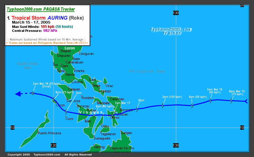
Severe Tropical Storm Roke (Auring)
Roke is a male Chamorro name. Seven people were killed and damages amounted to $166,000 (2005 USD).- Typhoon 2000's tracking chart of Typhoon Roke (Auring).
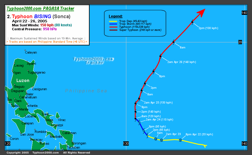
Typhoon Sonca (Bising)
Sonca is a singing bird found in Vietnam.- Typhoon 2000's tracking chart of Typhoon Sonca (Bising).
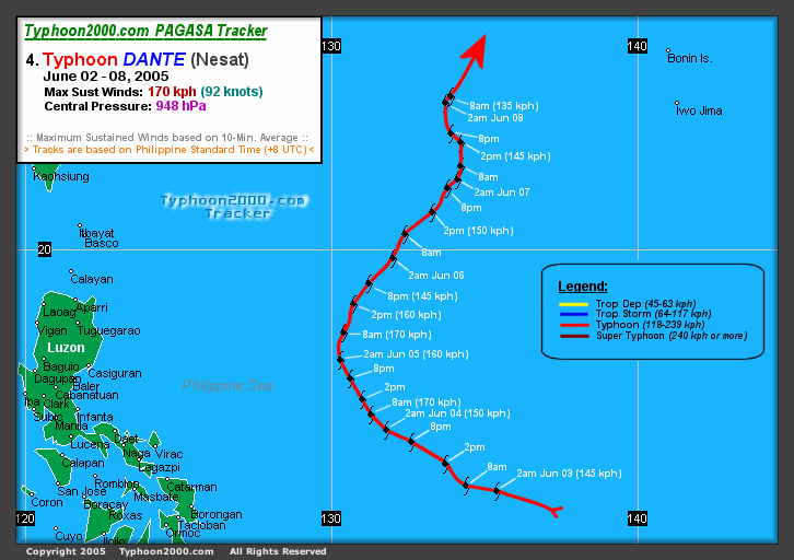
Typhoon Nesat (Dante)
Typhoon Nesat (Dante) was a powerful storm that formed on May 30 about 290 nautical miles (540 km) south-southeast of Guam as Tropical Depression 04W. It was quickly upgraded to Tropical Storm Nesat overnight at 1800 UTC (0200 PHTPhilippine Standard Time
Philippine Standard Time , also known as Philippine Time , is the official name for the time in the Philippines. The country only has one time zone, the UTC+08:00 time zone. The country used the daylight saving time for a short time...
May 31). Nesat is a Cambodian word for fisherman. On the evening of June 1, it strengthened into Typhoon Nesat. On June 2, it entered the Philippine area of responsibility and was assigned the name Dante for Philippine warnings. Typhoon Nesat (Dante) quickly grew to a Category 4 storm as it approached the Philippines, but it curved away to the northeast and did not pose a threat to land. Waxing and waning in strength it eventually became extratropical southeast of Honshū, Japan
Honshu
is the largest island of Japan. The nation's main island, it is south of Hokkaido across the Tsugaru Strait, north of Shikoku across the Inland Sea, and northeast of Kyushu across the Kanmon Strait...
at tropical storm strength on the morning of June 10 at 0000 UTC (0900 JST
Japan Standard Time
Japan Standard Time or JST is the standard timezone of Japan, and is 9 hours ahead of UTC. For example, when it is midnight in UTC, it is 09:00 in Japan Standard Time. There is no daylight saving time, though its introduction has been debated several times. Japan Standard Time is the same as...
).
- Typhoon 2000's tracking chart of Typhoon Nesat (Dante).
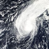
Typhoon Haitang (Feria)
Typhoon Haitang (Feria) was the first major typhoon of the 2005 season in the northwestern Pacific. It formed on the evening of July 11 as a poorly organized depression about 110 nautical miles (280 km) west of Marcus Island, Japan at 1200 UTC (2000 JST). By 1800 UTC (0300 JST July 13), it had reached tropical storm strength and was named Haitang, a Chinese name for flowering crabapple. It grew to typhoon strength at 1800 UTC (0300 JST July 14) the following day. As it moved westward it continued to gain in strength, reaching Category three status as it entered the Philippine area of responsibility. PAGASA named the storm Feria for Philippine warnings on July 15. By July 16, the storm continued tracking west and became a threat to TaiwanTaiwan
Taiwan , also known, especially in the past, as Formosa , is the largest island of the same-named island group of East Asia in the western Pacific Ocean and located off the southeastern coast of mainland China. The island forms over 99% of the current territory of the Republic of China following...
and Japan's Sakishima Islands
Sakishima Islands
The are an island chain located at the southernmost end of the Japanese Archipelago. They are part of the Nansei Islands and include the Miyako Islands and the Yaeyama Islands...
. Haitang strengthened into a Category 5 super typhoon. On July 17 it weakened to a Category 3 as it continued west, sparing Sakishima a direct hit but aiming directly for Taiwan. Typhoon Haitang made landfall near Hualien, Taiwan
Taiwan
Taiwan , also known, especially in the past, as Formosa , is the largest island of the same-named island group of East Asia in the western Pacific Ocean and located off the southeastern coast of mainland China. The island forms over 99% of the current territory of the Republic of China following...
at 0000 UTC (0800 HKT
Hong Kong Time
Hong Kong Time is the time in Hong Kong, observed at UTC+8 all year round. The Hong Kong Observatory is the official timekeeper of the Hong Kong Time.-Time standards:...
) on the morning of July 18. Taking a full day to cross the island and over the interior mountains, it caused flash floods and landslides killing four people. Weakening to a tropical storm as it entered the South China Sea, it reorganized into a minimal typhoon as it approached the southeast China coast. Haitang made landfall for the second time near Wenzhou
Wenzhou
Wenzhou is a prefecture-level city in southeastern Zhejiang province, People's Republic of China. The area under its jurisdiction, which includes two satellite cities and six counties, had a population of 9,122,100 as of 2010....
China on July 19 at 1200 UTC (2000 HKT). Moving inland, it rapidly lost its strength and dissipated. PAGASA stopped issuing advisories for the storm near Jiangxi
Jiangxi
' is a southern province in the People's Republic of China. Spanning from the banks of the Yangtze River in the north into hillier areas in the south, it shares a border with Anhui to the north, Zhejiang to the northeast, Fujian to the east, Guangdong to the south, Hunan to the west, and Hubei to...
on July 20.
- University of Hawaii's tracking chart of Super Typhoon Haitang (Feria).
Tropical Storm Nalgae
Tropical Storm Nalgae formed from a tropical disturbance 325 nautical miles (600 km) northwest of Wake IslandWake Island
Wake Island is a coral atoll having a coastline of in the North Pacific Ocean, located about two-thirds of the way from Honolulu west to Guam east. It is an unorganized, unincorporated territory of the United States, administered by the Office of Insular Affairs, U.S. Department of the Interior...
on the morning of July 20. Nalgae is a Korean word for wing. Nalgae did not reach typhoon intensity or threaten land. It turned to the north and then east, avoiding Japan.
- University of Hawaii's tracking chart of Tropical Storm Nalgae.
Severe Tropical Storm Banyan
Severe Tropical Storm Banyan formed from a tropical disturbance about 300 nautical miles (550 km) north of Yap Island on the evening of July 21 at 1200 UTC (2100 JST). Banyan is a tree common in India and southern China. Banyan brushed the southern and eastern coasts of Honshū, Japan on July 26. It became extratropical off the northeastern coast of HonshūHonshu
is the largest island of Japan. The nation's main island, it is south of Hokkaido across the Tsugaru Strait, north of Shikoku across the Inland Sea, and northeast of Kyushu across the Kanmon Strait...
on July 27.
- University of Hawaii's tracking chart of Tropical Storm Banyan.
Tropical Storm Washi
Tropical Storm Washi formed as a tropical depression about 215 nautical miles (400 km) south of Hong Kong. Washi is a Japanese word for the constellation AquilaAquila (constellation)
Aquila is a stellar constellation. Its name is Latin for 'eagle' and it is commonly represented as such. In mythology, Aquila was owned by the Roman god Jupiter and performed many tasks for him....
. The storm moved west towards Hainan
Hainan
Hainan is the smallest province of the People's Republic of China . Although the province comprises some two hundred islands scattered among three archipelagos off the southern coast, of its land mass is Hainan Island , from which the province takes its name...
. Tropical Storm Washi made its first landfall near Xinglong, Hainan. After re-entering the Gulf of Tonkin, the storm made its final landfall near Nam Dinh, Vietnam
Vietnam
Vietnam – sometimes spelled Viet Nam , officially the Socialist Republic of Vietnam – is the easternmost country on the Indochina Peninsula in Southeast Asia. It is bordered by China to the north, Laos to the northwest, Cambodia to the southwest, and the South China Sea –...
.
- University of Hawaii's tracking chart of Tropical Storm Washi.
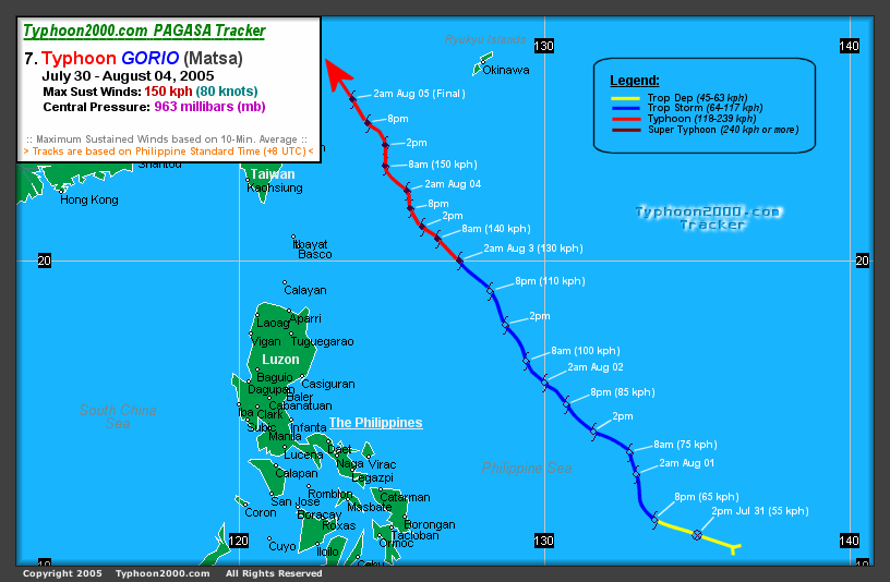
Typhoon Matsa (Gorio)
Typhoon Matsa (Gorio) formed as a depression 130 nautical miles (240 km) west northwest of Yap Island. Matsa is a Laotian name for a lady fish. Matsa formed east of and then moved into the Philippine area of responsibility. It has been assigned the name Gorio for Philippine advisories. Matsa passed between TaiwanTaiwan
Taiwan , also known, especially in the past, as Formosa , is the largest island of the same-named island group of East Asia in the western Pacific Ocean and located off the southeastern coast of mainland China. The island forms over 99% of the current territory of the Republic of China following...
and Okinawa with the center of the storm passing over the Yaeyama Islands
Yaeyama Islands
The Yaeyama Islands are a group of islands in Okinawa Prefecture, Japan.The isles are the remotest part of Japan from the main islands and contains Japan's most southern and most western inhabited islands.The islands form the southern part of the volcanic Nansei Islands...
of Japan on the evening of August 4. The storm made landfall near Zhejiang
Zhejiang
Zhejiang is an eastern coastal province of the People's Republic of China. The word Zhejiang was the old name of the Qiantang River, which passes through Hangzhou, the provincial capital...
, Anhui
Anhui
Anhui is a province in the People's Republic of China. Located in eastern China across the basins of the Yangtze River and the Huai River, it borders Jiangsu to the east, Zhejiang to the southeast, Jiangxi to the south, Hubei to the southwest, Henan to the northwest, and Shandong for a tiny...
, Jiangsu
Jiangsu
' is a province of the People's Republic of China, located along the east coast of the country. The name comes from jiang, short for the city of Jiangning , and su, for the city of Suzhou. The abbreviation for this province is "苏" , the second character of its name...
and Shanghai on mainland China
Mainland China
Mainland China, the Chinese mainland or simply the mainland, is a geopolitical term that refers to the area under the jurisdiction of the People's Republic of China . According to the Taipei-based Mainland Affairs Council, the term excludes the PRC Special Administrative Regions of Hong Kong and...
on the morning of August 6 with maximum sustained winds of 145 km/h (90 mph). The storm rapidly dissipated inland over China but remnants brought heavy rain inland west of Shanghai.
- Typhoon 2000's tracking chart of Typhoon Matsa (Gorio).
Severe Tropical Storm Sanvu (Huaning)
Philippine Standard Time
Philippine Standard Time , also known as Philippine Time , is the official name for the time in the Philippines. The country only has one time zone, the UTC+08:00 time zone. The country used the daylight saving time for a short time...
) 320 nautical miles east-northeast of Borongan on Samar Island
Samar Island
Samar is an island in the Visayas, within the central Philippines. The island is divided into three provinces: Samar province, Northern Samar, and Eastern Samar. These three provinces, along with the provinces on the nearby islands of Leyte and Biliran are part of the Eastern Visayas region...
inside the Philippine area of responsibility. PAGASA assigns names to Tropical Depressions because they often bring heavy rains and mudslides to the Philippines. Storm was named Tropical Depression Huaning for Philippine warnings but within 24 hours received the more recognized name Sanvu when it became a Tropical Storm. Sanvu is a Chinese name for coral. Tropical Storm Sanvu (Huaning) passed over a peninsula in Cagayan
Cagayan
Cagayan , the "Land of Smiling Beauty", is a province of the Philippines in the Cagayan Valley region in Luzon. Its capital is Tuguegarao City and is located at the northeastern corner of the island of Luzon. Cagayan also includes the Babuyan Islands to the north. The province borders Ilocos Norte...
province on the island of Luzon
Luzon
Luzon is the largest island in the Philippines. It is located in the northernmost region of the archipelago, and is also the name for one of the three primary island groups in the country centered on the Island of Luzon...
early on the morning of August 12. It was upgraded to a typhoon before making landfall in China the next day on August 13. Sanvu (Huaning) rapidly dissipated after moving inland on August 14.
Sanvu was the first typhoon that necessitated a tropical cyclone signal for Hong Kong.
- Typhoon 2000's tracking chart of Typhoon Sanvu (Huaning).
Typhoon Mawar
Typhoon Mawar formed as a tropical depression on the evening of August 19 at 1200 UTC (2100 JST) 245 nautical miles (455 kilometers) southeast of Iwo JimaIwo Jima
Iwo Jima, officially , is an island of the Japanese Volcano Islands chain, which lie south of the Ogasawara Islands and together with them form the Ogasawara Archipelago. The island is located south of mainland Tokyo and administered as part of Ogasawara, one of eight villages of Tokyo...
. Mawar is a Malay word for a rose. The storm intensified rapidly in two days to a Category 4 Super Typhoon but weakened as it approached Japan. Mawar made landfall on Honshū
Honshu
is the largest island of Japan. The nation's main island, it is south of Hokkaido across the Tsugaru Strait, north of Shikoku across the Inland Sea, and northeast of Kyushu across the Kanmon Strait...
as a Category 2 Typhoon on August 25 at 1800 UTC (August 26 0300 JST) with winds of 95 mph (152 km/h). After moving inland to the northwest it was downgraded to a Category 1 before entering the Pacific Ocean. It was downgraded to a Tropical Storm on August 26 and became extratropical on August 27. At least two people were killed by Mawar.
- University of Hawaii's tracking chart of Super Typhoon Mawar.
Severe Tropical Storm Guchol
Severe Tropical Storm Guchol formed as a tropical depression on the morning of August 20 at 0000 UTC (0900 JSTJapan Standard Time
Japan Standard Time or JST is the standard timezone of Japan, and is 9 hours ahead of UTC. For example, when it is midnight in UTC, it is 09:00 in Japan Standard Time. There is no daylight saving time, though its introduction has been debated several times. Japan Standard Time is the same as...
) 190 nautical miles (350 kilometers) southwest of Marcus Island, Japan. It reached Tropical Storm strength the next day and was named Guchol, a Yapese name for the spice turmeric
Turmeric
Turmeric is a rhizomatous herbaceous perennial plant of the ginger family, Zingiberaceae. It is native to tropical South Asia and needs temperatures between 20 °C and 30 °C and a considerable amount of annual rainfall to thrive...
. Guchol curved to the northwest and never threatened land. It became extratropical August 25 at 0000 UTC (0900 JST) 735 nautical miles (1,285 km) east-southeast of Nakashibetsu, Hokkaidō
Hokkaido
, formerly known as Ezo, Yezo, Yeso, or Yesso, is Japan's second largest island; it is also the largest and northernmost of Japan's 47 prefectural-level subdivisions. The Tsugaru Strait separates Hokkaido from Honshu, although the two islands are connected by the underwater railway Seikan Tunnel...
, Japan.
- Weather Underground's tracking chart of Tropical Storm Guchol.
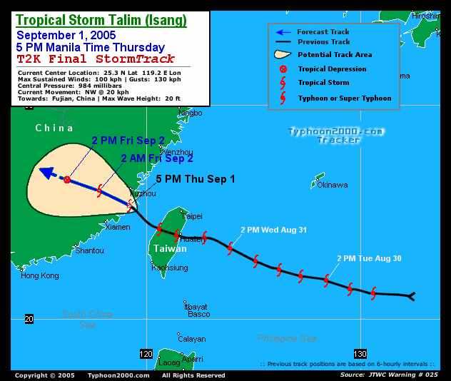
Typhoon Talim (Isang)
Tropical Depression 13W formed on the afternoon of August 26 at 0600 UTC northeast of the island of YapYap
Yap, also known as Wa'ab by locals, is an island in the Caroline Islands of the western Pacific Ocean. It is a state of the Federated States of Micronesia. Yap's indigenous cultures and traditions are still strong compared to other neighboring islands. The island of Yap actually consists of four...
. Within 24 hours it was upgraded to Tropical Storm Talim and the next day became a Typhoon. Talim is a Philippine name for a knife or sharp cutting edge. Typhoon Talim was assigned the name Typhoon Isang for Philippine warnings when it entered the Philippine area of responsibility on August 29. Typhoon Talim (Isang) made landfall at 1800 UTC August 31 (0200 PHT
Philippine Standard Time
Philippine Standard Time , also known as Philippine Time , is the official name for the time in the Philippines. The country only has one time zone, the UTC+08:00 time zone. The country used the daylight saving time for a short time...
September 1) as a Category 3 storm. Talim dissipated over southeastern China on September 1. Typhoon Talim left at least 110 people dead and 23 missing in Fujian
Fujian
' , formerly romanised as Fukien or Huguing or Foukien, is a province on the southeast coast of mainland China. Fujian is bordered by Zhejiang to the north, Jiangxi to the west, and Guangdong to the south. Taiwan lies to the east, across the Taiwan Strait...
, Zhejiang
Zhejiang
Zhejiang is an eastern coastal province of the People's Republic of China. The word Zhejiang was the old name of the Qiantang River, which passes through Hangzhou, the provincial capital...
, Jiangxi
Jiangxi
' is a southern province in the People's Republic of China. Spanning from the banks of the Yangtze River in the north into hillier areas in the south, it shares a border with Anhui to the north, Zhejiang to the northeast, Fujian to the east, Guangdong to the south, Hunan to the west, and Hubei to...
& Anhui
Anhui
Anhui is a province in the People's Republic of China. Located in eastern China across the basins of the Yangtze River and the Huai River, it borders Jiangsu to the east, Zhejiang to the southeast, Jiangxi to the south, Hubei to the southwest, Henan to the northwest, and Shandong for a tiny...
provinces, with at least 40 people dead in the latter province due to landslides. It also left 7 dead in Taiwan. http://news.yahoo.com/news?tmpl=story&u=/afp/20050903/wl_afp/chinaweather_050903153304
- Typhoon 2000's tracking chart of Typhoon Talim (Isang).
Typhoon Nabi (Jolina)
Typhoon Nabi (Jolina) formed from a tropical depression on the afternoon of August 29 at 0600 UTC (1600 AEST) east of SaipanSaipan
Saipan is the largest island of the United States Commonwealth of the Northern Mariana Islands , a chain of 15 tropical islands belonging to the Marianas archipelago in the western Pacific Ocean with a total area of . The 2000 census population was 62,392...
. 18 hours later it was upgraded to Tropical Storm Nabi. Nabi is a Korean word for a butterfly
Butterfly
A butterfly is a mainly day-flying insect of the order Lepidoptera, which includes the butterflies and moths. Like other holometabolous insects, the butterfly's life cycle consists of four parts: egg, larva, pupa and adult. Most species are diurnal. Butterflies have large, often brightly coloured...
. It strengthened into a Typhoon on August 30 and passed near the islands of Saipan
Saipan
Saipan is the largest island of the United States Commonwealth of the Northern Mariana Islands , a chain of 15 tropical islands belonging to the Marianas archipelago in the western Pacific Ocean with a total area of . The 2000 census population was 62,392...
and Guam
Guam
Guam is an organized, unincorporated territory of the United States located in the western Pacific Ocean. It is one of five U.S. territories with an established civilian government. Guam is listed as one of 16 Non-Self-Governing Territories by the Special Committee on Decolonization of the United...
on August 31.After passing near the Marianas Islands, the storm continued to strengthen until reaching Category 5 intensity on September 1. Typhoon Nabi was assigned the name Jolina for Philippine warnings when it entered the Philippine area of responsibility on September 3. Typhoon Nabi (Jolina) passed to the east of the island of Okinawa, Japan, and made landfall in the Kagoshima Prefecture
Kagoshima Prefecture
is a prefecture of Japan located on the island of Kyushu. The capital is the city of Kagoshima.- Geography :Kagoshima Prefecture is located at the southwest tip of Kyushu and includes a chain of islands stretching further to the southwest for a few hundred kilometers...
of Japan on September 6 as a Category 2 storm. It dissipated shortly after that.
Twenty-one deaths have been reported in Japan. On September 8, five people were missing in South Korea and fifty in Japan as a result of the storm. Japan also reported 143 injured. The storm damaged 10,000 homes in Japan, where 31 of 47 prefectures reported some damage. Eighty-eight roads in Japan were damaged, and 168 landslides were reported there. The heaviest damage was in Miyazaki prefecture
Miyazaki Prefecture
is a prefecture of Japan located on the island of Kyushu. The capital is the city of Miyazaki.- History :Historically, after the Meiji Restoration, Hyūga Province was renamed Miyazaki Prefecture....
on the island of Kyūshū
Kyushu
is the third largest island of Japan and most southwesterly of its four main islands. Its alternate ancient names include , , and . The historical regional name is referred to Kyushu and its surrounding islands....
. There were no deaths in the Marianas Islands. Saipan did experience heavy wind gusts of 120 km/h (75 mph). Guam
Guam
Guam is an organized, unincorporated territory of the United States located in the western Pacific Ocean. It is one of five U.S. territories with an established civilian government. Guam is listed as one of 16 Non-Self-Governing Territories by the Special Committee on Decolonization of the United...
experienced gale-force wind gusts in addition to approximately 75 mm (3 in) of rain.
Due to the effects of the storm in Japan, the name "Nabi" was later retired, and was replaced by "Doksuri".
http://www.kpua.net/news.php?id=6120
Typhoon Khanun (Kiko)
Tropical Depression 15W formed from a well-defined low pressure system located about 50 nautical miles (95 km) east of YapYap
Yap, also known as Wa'ab by locals, is an island in the Caroline Islands of the western Pacific Ocean. It is a state of the Federated States of Micronesia. Yap's indigenous cultures and traditions are still strong compared to other neighboring islands. The island of Yap actually consists of four...
on September 6. It strengthened into a tropical storm later that day. The system was classified as a tropical storm by the Joint Typhoon Warning Center
Joint Typhoon Warning Center
The Joint Typhoon Warning Center is a joint United States Navy – United States Air Force task force located at the Naval Maritime Forecast Center in Pearl Harbor, Hawaii...
on September 6, while the Japan Meteorological Agency
Japan Meteorological Agency
The or JMA, is the Japanese government's weather service. Charged with gathering and reporting weather data and forecasts in Japan, it is a semi-autonomous part of the Ministry of Land, Infrastructure and Transport...
, the agency responsible for naming typhoons, did not upgrade the system until a day later. Tropical Storm 15W entered the Philippine area of responsibility on September 7. It was named Kiko by PAGASA first before being named Khanun by the JMA. Khanun is the Thai name for jackfruit
Jackfruit
The jackfruit is a species of tree in the Artocarpus genus of the mulberry family . It is native to parts of Southern and Southeast Asia. It is the national fruit of Bangladesh, . The jackfruit tree is believed to be indigenous to the southwestern rain forests of India...
. Typhoon Khanun (Kiko) made landfall in eastern China on September 11 at 0600 UTC (1400 HKT). Khanun dissipated the next day, September 12.
More than 800,000 people were evacuated from their homes as the storm neared. Many people, evacuated by the army, were taken to schools, railway stations, hotels and other solid buildings to take shelter from the approaching storm.
The city of Taizhou, Zhejiang
Taizhou, Zhejiang
Taizhou is a prefecture-level city in middle eastern Zhejiang province, People's Republic of China...
bore the initial brunt of the storm as it was close the where the storm made landfall, 220 km south of Shanghai. Other coastal cities braced for the typhoon as it headed north. At least 14 people were killed and 1 went missing in Zhejiang province. Damages totaled to $849 million (2005 USD).
Japan's southern Ryūkyū Islands
Ryukyu Islands
The , also known as the , is a chain of islands in the western Pacific, on the eastern limit of the East China Sea and to the southwest of the island of Kyushu in Japan. From about 1829 until the mid 20th century, they were alternately called Luchu, Loochoo, or Lewchew, akin to the Mandarin...
suffered strong winds, high waves and heavy rains as the storm passed. Opening hours at some polling stations were altered to make sure citizens could still vote in the Japanese general election
Japan general election, 2005
A general election in Japan was held on 11 September 2005 for all 480 seats of the House of Representatives of Japan, the lower house of the Diet of Japan, almost two years before the end of the term taken from the last election in 2003...
despite the weather.
- JTWC's Tracking Chart of Typhoon Khanun (Kiko).
Tropical Storm Vicente
Tropical Depression 16W formed 205 nautical miles (375 km) east-southeast of Dong Tac, VietnamVietnam
Vietnam – sometimes spelled Viet Nam , officially the Socialist Republic of Vietnam – is the easternmost country on the Indochina Peninsula in Southeast Asia. It is bordered by China to the north, Laos to the northwest, Cambodia to the southwest, and the South China Sea –...
on the morning of September 16. It reached Tropical Storm strength overnight local time and was named Vicente, a Chamorro male name. Shortly after forming, Vicente interacted with a tropical disturbance west of Luzon and made a cyclonic loop. Vicente then absorbed the disturbance before passing just south of Hainan Island. Eventually, Vicente tracked into the Vietnam coast northwest of Huế
Hue
Hue is one of the main properties of a color, defined technically , as "the degree to which a stimulus can be describedas similar to or different from stimuli that are described as red, green, blue, and yellow,"...
on September 18 and gradually dissipated.
As the pressure gradient between Vicente and a ridge of high pressure over southeastern China brought a strong easterly airstream to the coastal areas of Guangdong and caused rough seas with swells, a swimmer was drowned on September 17. Another one drowned the following day in rough seas at Sai Kung, Hong Kong.
Also, a ship from China struck a reef between Shangchuan and Xiachuan Islands. All seventeen crew members were rescued.
In Vietnam, about 5 people were killed or reported missing.
- Weather Underground's tracking chart of Tropical Storm Vicente
Typhoon Saola
Japan Meteorological Agency initiated a warning for Tropical Depression 18W southwest of Marcus Island, Japan at 0000 UTC (0900 JST), September 20. The depression was upgraded to Tropical Storm Saola 18 hours later as it continued to strengthen moving westward. The name Saola comes from saolaSaola
The Saola, Vu Quang ox or Asian unicorn, also, infrequently, Vu Quang bovid , one of the world's rarest mammals, is a forest-dwelling bovine found only in the Annamite Range of Vietnam and Laos...
, a newly discovered endangered species in Vietnam
Vietnam
Vietnam – sometimes spelled Viet Nam , officially the Socialist Republic of Vietnam – is the easternmost country on the Indochina Peninsula in Southeast Asia. It is bordered by China to the north, Laos to the northwest, Cambodia to the southwest, and the South China Sea –...
. Saola was further upgraded to a typhoon at 0300 UTC (1200 JST) September 22. Saola became extratropical 370 nautical miles (685.2 km) northeast of Tokyo four days later.
- Weather Underground's tracking chart of Typhoon Saola.
Typhoon Damrey (Labuyo)
Due to its proximity to the PhilippinesPhilippines
The Philippines , officially known as the Republic of the Philippines , is a country in Southeast Asia in the western Pacific Ocean. To its north across the Luzon Strait lies Taiwan. West across the South China Sea sits Vietnam...
, PAGASA assigned it the name Labuyo and began issuing advisories on a disturbed area of tropical weather to the east of the islands on September 19. On September 20 it was classified as Tropical Depression 17W by the Joint Typhoon Warning Center
Joint Typhoon Warning Center
The Joint Typhoon Warning Center is a joint United States Navy – United States Air Force task force located at the Naval Maritime Forecast Center in Pearl Harbor, Hawaii...
. On September 21, it was upgraded to Tropical Storm Damrey. It strengthened into a typhoon on September 24. Damrey is a Cambodian word for elephant.
Typhoon Damrey (Labuyo) made landfall at Wanning
Wanning
Wanning is a county-level city in SE Hainan province, China, with an estimated population of 65,871 .-History:Wanning lies on the east of the island and administers many small towns...
, in China's Hainan
Hainan
Hainan is the smallest province of the People's Republic of China . Although the province comprises some two hundred islands scattered among three archipelagos off the southern coast, of its land mass is Hainan Island , from which the province takes its name...
province at 2000 UTC, September 25 (0400 September 26 local time) with maximum sustained winds up to 180 km/h. This made Damrey the strongest typhoon to strike Hainan since Typhoon Marge in September 1973.
At least 16 people are believed to have died in China, and the entire province of Hainan suffered power outages. Damrey then went on to impact Vietnam
Vietnam
Vietnam – sometimes spelled Viet Nam , officially the Socialist Republic of Vietnam – is the easternmost country on the Indochina Peninsula in Southeast Asia. It is bordered by China to the north, Laos to the northwest, Cambodia to the southwest, and the South China Sea –...
before losing tropical characteristics while a Tropical Storm. The Joint Typhoon Warning Center ceased advisories with the final one at 0900 UTC September 27 with the system 90 nautical miles (166.7 km) south-southwest of Hanoi
Hanoi
Hanoi , is the capital of Vietnam and the country's second largest city. Its population in 2009 was estimated at 2.6 million for urban districts, 6.5 million for the metropolitan jurisdiction. From 1010 until 1802, it was the most important political centre of Vietnam...
, Vietnam.
- Weather Underground's tracking chart of Typhoon Damrey (Labuyo).
Typhoon Longwang (Maring)
Tropical Depression 19W formed about 335 nautical miles (620.4 km) south-southeast of Iwo JimaIwo Jima
Iwo Jima, officially , is an island of the Japanese Volcano Islands chain, which lie south of the Ogasawara Islands and together with them form the Ogasawara Archipelago. The island is located south of mainland Tokyo and administered as part of Ogasawara, one of eight villages of Tokyo...
, Japan on September 26. The Joint Typhoon Warning Center
Joint Typhoon Warning Center
The Joint Typhoon Warning Center is a joint United States Navy – United States Air Force task force located at the Naval Maritime Forecast Center in Pearl Harbor, Hawaii...
initiated a warning for it at 0000 UTC the same day, and was upgraded to Tropical Storm Longwang six hours later. Longwang is Chinese for Dragon King. At 0300 UTC September 27, the Joint Typhoon Warning Center upgraded it to a typhoon. It continued to increase in strength as it tracked west to west-northwest towards Taiwan
Taiwan
Taiwan , also known, especially in the past, as Formosa , is the largest island of the same-named island group of East Asia in the western Pacific Ocean and located off the southeastern coast of mainland China. The island forms over 99% of the current territory of the Republic of China following...
, and was upgraded to a super typhoon on September 29. PAGASA named the storm Maring for Philippine warnings on September 29. Longwang made landfall at 0515 local time on October 2 south of Hualien City
Hualien City
Hualien City is the capital of Hualien County, Taiwan. It is located on the East coast of Taiwan, by the Pacific Ocean, and has a population of 110,000 inhabitants.- History :...
, Taiwan
Taiwan
Taiwan , also known, especially in the past, as Formosa , is the largest island of the same-named island group of East Asia in the western Pacific Ocean and located off the southeastern coast of mainland China. The island forms over 99% of the current territory of the Republic of China following...
as a Category 4 storm. Half a day later, at 2135 local time (1335 UTC), it made second landfall in Fujian Province, China as a minimal typhoon. Longwang dissipated on the next day.
Despite its intensity, Longwang caused mostly property damage, and claimed only one life in Taiwan.
- Weather Underground's tracking chart of Typhoon Longwang (Maring).
Typhoon Kirogi (Nando)
Japan Meteorological Agency began issuing warnings for a Tropical Depression southeast of Okinawa at 1200 UTC, October 9 and assigned the name Kirogi to it at 0600 UTC next day. Prior to becoming a Tropical Storm it entered the Philippine area of responsibility and was assigned the name Nando by PAGASA for Philippine warnings. JTWC finally issued a warning for Kirogi at 0900 UTC, October 10, despite listing it as a Tropical Depression. It was upgraded to a typhoon at 0000 UTC October 12, and reached Category 4 strength about nine hours later. Kirogi is a Korean word for a type of migrating bird that lives in North KoreaNorth Korea
The Democratic People’s Republic of Korea , , is a country in East Asia, occupying the northern half of the Korean Peninsula. Its capital and largest city is Pyongyang. The Korean Demilitarized Zone serves as the buffer zone between North Korea and South Korea...
from autumn to spring. Kirogi was declared extratropical at 0300 UTC October 19.
Typhoon Kai-tak
The Japan Meteorological Agency initiated marine warnings for a Tropical Depression in the South China Sea on October 28. Fifteen hours later, the Joint Typhoon Warning Center issued the number 22W to the system. The next day it was upgraded to Tropical Storm Kai-tak. Kai-tak was a name submitted by Hong Kong in honor of their former airportKai Tak Airport
Kai Tak Airport was the international airport of Hong Kong from 1925 until 1998. It was officially known as the Hong Kong International Airport from 1954 to 6 July 1998, when it was closed and replaced by the new Hong Kong International Airport at Chek Lap Kok, 30 km to the west...
. On October 30 it was upgraded to a Typhoon. Kai-tak made landfall north of Huế
Hue
Hue is one of the main properties of a color, defined technically , as "the degree to which a stimulus can be describedas similar to or different from stimuli that are described as red, green, blue, and yellow,"...
, Vietnam, early on the morning of November 2. At least 19 people were killed and 10 others were left missing in Vietnam. Damages from the storm were estimated to be at least $11 million (2005 USD).
- UNISYS track chart of Typhoon Kai-tak
The 2005 Pacific typhoon season had no official bounds; it ran year-round in 2005, but most tropical cyclones tend to form in the northwestern Pacific Ocean between May and November. These dates conventionally delimit the period of each year when most tropical cyclones form in the northwestern Pacific Ocean.
The scope of this article is limited to the Pacific Ocean, north of the equator and west of the international date line
International Date Line
The International Date Line is a generally north-south imaginary line on the surface of the Earth, passing through the middle of the Pacific Ocean, that designates the place where each calendar day begins...
. Storms that form east of the date line and north of the equator are called hurricanes; see 2005 Pacific hurricane season
2005 Pacific hurricane season
The 2005 Pacific hurricane season officially began on May 15, 2005 in the eastern Pacific and on June 1, 2005 in the central Pacific, and lasted until November 30, 2005. These dates conventionally delimit the period of each year when most tropical cyclones form in the northeastern Pacific Ocean...
. Tropical storms that form in the West Pacific basin are assigned a name by the Japan Meteorological Agency
Japan Meteorological Agency
The or JMA, is the Japanese government's weather service. Charged with gathering and reporting weather data and forecasts in Japan, it is a semi-autonomous part of the Ministry of Land, Infrastructure and Transport...
. Tropical depressions in this basin have the "W" suffix added to their number. Tropical depressions that enter or form in the Philippine area of responsibility
Philippine Atmospheric, Geophysical and Astronomical Services Administration
The Philippine Atmospheric, Geophysical and Astronomical Services Administration is a Philippine national institution dedicated to provide flood and typhoon warnings, public weather forecasts and advisories, meteorological, astronomical, climatological, and other specialized information and...
are assigned a name by the Philippine Atmospheric, Geophysical and Astronomical Services Administration
Philippine Atmospheric, Geophysical and Astronomical Services Administration
The Philippine Atmospheric, Geophysical and Astronomical Services Administration is a Philippine national institution dedicated to provide flood and typhoon warnings, public weather forecasts and advisories, meteorological, astronomical, climatological, and other specialized information and...
or PAGASA. This can often result in the same storm having two names.
This season, the circular list of 140 names, in use since January 1, 2000, was recycled following the formation of Typhoons Saola; the final name on the list, and Damrey; the first name on the list.
Storms
Please note that on the following list, storms are listed by Tropical Depression number, and therefore Saola (18W), which is on the naming list before Damrey (17W), is listed after Damrey, having been the later storm to form, despite being the earlier to attain Tropical Storm status. Also, windspeed advisories differ from the Joint Typhoon Warning Center to the Japan Meteorological Agency as the JTWC uses the U.S. criteria of 1 minute mean to designate maximum sustained winds, while the JMA uses the 10-minute mean wind criteria to designate tropical cyclone maximum sustained winds. This difference generally means that JTWC maximum winds will appear to be higher than the maximum winds described by the JMA for the same cyclone.Severe Tropical Storm Kulap
On January 12, a tropical disturbance developed within an area of light vertical wind shearWind shear
Wind shear, sometimes referred to as windshear or wind gradient, is a difference in wind speed and direction over a relatively short distance in the atmosphere...
. This allowed deep convection
Atmospheric convection
Atmospheric convection is the result of a parcel-environment instability, or temperature difference, layer in the atmosphere. Different lapse rates within dry and moist air lead to instability. Mixing of air during the day which expands the height of the planetary boundary layer leads to...
to develop over a broad low-level circulation
Low pressure area
A low-pressure area, or "low", is a region where the atmospheric pressure at sea level is below that of surrounding locations. Low-pressure systems form under areas of wind divergence which occur in upper levels of the troposphere. The formation process of a low-pressure area is known as...
. The next day, the Joint Typhoon Warning Center
Joint Typhoon Warning Center
The Joint Typhoon Warning Center is a joint United States Navy – United States Air Force task force located at the Naval Maritime Forecast Center in Pearl Harbor, Hawaii...
(JTWC) issued a Tropical Cyclone Formation Alert
Tropical Cyclone Formation Alert
A Tropical Cyclone Formation Alert is a bulletin released by the U.S. Navy-operated Joint Typhoon Warning Center in Honolulu, Hawaii or the Naval Maritime Forecast Center in Norfolk, Virginia, warning of the possibility of a tropical cyclone forming from a tropical disturbance that has been...
(TCFA) as the system continued to develop. Later that day, they issued their first advisory on Tropical Depression 01W while the storm was located about 215 km (130 mi) southwest of Chuuk
Chuuk
Chuuk — formerly Truk, Ruk, Hogoleu, Torres, Ugulat, and Lugulus — is an island group in the south western part of the Pacific Ocean. It comprises one of the four states of the Federated States of Micronesia , along with Kosrae, Pohnpei, and Yap. Chuuk is the most populous of the FSM's...
. Several hours later, the Japan Meteorological Agency
Japan Meteorological Agency
The or JMA, is the Japanese government's weather service. Charged with gathering and reporting weather data and forecasts in Japan, it is a semi-autonomous part of the Ministry of Land, Infrastructure and Transport...
(JMA) also designated the system as a tropical depression. Early on January 15, the JTWC upgraded 01W to a tropical storm as the system turned towards the north. The northward movement was the result of the system traveling along the edge of a low to mid-level ridge
High pressure area
A high-pressure area is a region where the atmospheric pressure at the surface of the planet is greater than its surrounding environment. Winds within high-pressure areas flow outward due to the higher density air near their center and friction with land...
located to the east. About 12 hours later, the JMA upgraded the depression to a tropical storm and gave it the name Kulap; which was contributed by Thailand
Thailand
Thailand , officially the Kingdom of Thailand , formerly known as Siam , is a country located at the centre of the Indochina peninsula and Southeast Asia. It is bordered to the north by Burma and Laos, to the east by Laos and Cambodia, to the south by the Gulf of Thailand and Malaysia, and to the...
and is the Thai word for rose
Rose
A rose is a woody perennial of the genus Rosa, within the family Rosaceae. There are over 100 species. They form a group of erect shrubs, and climbing or trailing plants, with stems that are often armed with sharp prickles. Flowers are large and showy, in colours ranging from white through yellows...
. Kulap gradually intensified over the next two days, reaching reaching its peak intensity with winds of 95 km/h (60 mph 10-minute winds) around 1800 UTC
Coordinated Universal Time
Coordinated Universal Time is the primary time standard by which the world regulates clocks and time. It is one of several closely related successors to Greenwich Mean Time. Computer servers, online services and other entities that rely on having a universally accepted time use UTC for that purpose...
on January 17, making it a severe tropical storm according to the JMA. However, at the same time the JMA assessed Kulap to have reached its peak intensity, the JTWC classified it as a minimal typhoon with winds of 120 km/h (75 mph 1-minute winds). Shortly after reaching its peak intensity, the storm began to undergo an extratropical transition
Extratropical cyclone
Extratropical cyclones, sometimes called mid-latitude cyclones or wave cyclones, are a group of cyclones defined as synoptic scale low pressure weather systems that occur in the middle latitudes of the Earth having neither tropical nor polar characteristics, and are connected with fronts and...
and weaken. Late on January 18, the JTWC issued their final advisory on Kulap despite the storm remaining tropical. The JMA considered Kulap to have been a tropical storm until early the next day. The storm dissipated as a weak extratropical system around 1200 UTC on January 19. Between January 13 and 14, the storm produced heavy rains over the island of Chuuk. Upwards of 300 mm (12 in) of rain fell during the two day span, of which 166.6 mm (6.5 in) fell in 24 hours.
Severe Tropical Storm Roke (Auring)
Roke is a male Chamorro name. Seven people were killed and damages amounted to $166,000 (2005 USD).- Typhoon 2000's tracking chart of Typhoon Roke (Auring).
Typhoon Sonca (Bising)
Sonca is a singing bird found in Vietnam.- Typhoon 2000's tracking chart of Typhoon Sonca (Bising).
Typhoon Nesat (Dante)
Typhoon Nesat (Dante) was a powerful storm that formed on May 30 about 290 nautical miles (540 km) south-southeast of Guam as Tropical Depression 04W. It was quickly upgraded to Tropical Storm Nesat overnight at 1800 UTC (0200 PHTPhilippine Standard Time
Philippine Standard Time , also known as Philippine Time , is the official name for the time in the Philippines. The country only has one time zone, the UTC+08:00 time zone. The country used the daylight saving time for a short time...
May 31). Nesat is a Cambodian word for fisherman. On the evening of June 1, it strengthened into Typhoon Nesat. On June 2, it entered the Philippine area of responsibility and was assigned the name Dante for Philippine warnings. Typhoon Nesat (Dante) quickly grew to a Category 4 storm as it approached the Philippines, but it curved away to the northeast and did not pose a threat to land. Waxing and waning in strength it eventually became extratropical southeast of Honshū, Japan
Honshu
is the largest island of Japan. The nation's main island, it is south of Hokkaido across the Tsugaru Strait, north of Shikoku across the Inland Sea, and northeast of Kyushu across the Kanmon Strait...
at tropical storm strength on the morning of June 10 at 0000 UTC (0900 JST
Japan Standard Time
Japan Standard Time or JST is the standard timezone of Japan, and is 9 hours ahead of UTC. For example, when it is midnight in UTC, it is 09:00 in Japan Standard Time. There is no daylight saving time, though its introduction has been debated several times. Japan Standard Time is the same as...
).
- Typhoon 2000's tracking chart of Typhoon Nesat (Dante).
Typhoon Haitang (Feria)
Typhoon Haitang (Feria) was the first major typhoon of the 2005 season in the northwestern Pacific. It formed on the evening of July 11 as a poorly organized depression about 110 nautical miles (280 km) west of Marcus Island, Japan at 1200 UTC (2000 JST). By 1800 UTC (0300 JST July 13), it had reached tropical storm strength and was named Haitang, a Chinese name for flowering crabapple. It grew to typhoon strength at 1800 UTC (0300 JST July 14) the following day. As it moved westward it continued to gain in strength, reaching Category three status as it entered the Philippine area of responsibility. PAGASA named the storm Feria for Philippine warnings on July 15. By July 16, the storm continued tracking west and became a threat to TaiwanTaiwan
Taiwan , also known, especially in the past, as Formosa , is the largest island of the same-named island group of East Asia in the western Pacific Ocean and located off the southeastern coast of mainland China. The island forms over 99% of the current territory of the Republic of China following...
and Japan's Sakishima Islands
Sakishima Islands
The are an island chain located at the southernmost end of the Japanese Archipelago. They are part of the Nansei Islands and include the Miyako Islands and the Yaeyama Islands...
. Haitang strengthened into a Category 5 super typhoon. On July 17 it weakened to a Category 3 as it continued west, sparing Sakishima a direct hit but aiming directly for Taiwan. Typhoon Haitang made landfall near Hualien, Taiwan
Taiwan
Taiwan , also known, especially in the past, as Formosa , is the largest island of the same-named island group of East Asia in the western Pacific Ocean and located off the southeastern coast of mainland China. The island forms over 99% of the current territory of the Republic of China following...
at 0000 UTC (0800 HKT
Hong Kong Time
Hong Kong Time is the time in Hong Kong, observed at UTC+8 all year round. The Hong Kong Observatory is the official timekeeper of the Hong Kong Time.-Time standards:...
) on the morning of July 18. Taking a full day to cross the island and over the interior mountains, it caused flash floods and landslides killing four people. Weakening to a tropical storm as it entered the South China Sea, it reorganized into a minimal typhoon as it approached the southeast China coast. Haitang made landfall for the second time near Wenzhou
Wenzhou
Wenzhou is a prefecture-level city in southeastern Zhejiang province, People's Republic of China. The area under its jurisdiction, which includes two satellite cities and six counties, had a population of 9,122,100 as of 2010....
China on July 19 at 1200 UTC (2000 HKT). Moving inland, it rapidly lost its strength and dissipated. PAGASA stopped issuing advisories for the storm near Jiangxi
Jiangxi
' is a southern province in the People's Republic of China. Spanning from the banks of the Yangtze River in the north into hillier areas in the south, it shares a border with Anhui to the north, Zhejiang to the northeast, Fujian to the east, Guangdong to the south, Hunan to the west, and Hubei to...
on July 20.
- University of Hawaii's tracking chart of Super Typhoon Haitang (Feria).
Tropical Storm Nalgae
Tropical Storm Nalgae formed from a tropical disturbance 325 nautical miles (600 km) northwest of Wake IslandWake Island
Wake Island is a coral atoll having a coastline of in the North Pacific Ocean, located about two-thirds of the way from Honolulu west to Guam east. It is an unorganized, unincorporated territory of the United States, administered by the Office of Insular Affairs, U.S. Department of the Interior...
on the morning of July 20. Nalgae is a Korean word for wing. Nalgae did not reach typhoon intensity or threaten land. It turned to the north and then east, avoiding Japan.
- University of Hawaii's tracking chart of Tropical Storm Nalgae.
Severe Tropical Storm Banyan
Severe Tropical Storm Banyan formed from a tropical disturbance about 300 nautical miles (550 km) north of Yap Island on the evening of July 21 at 1200 UTC (2100 JST). Banyan is a tree common in India and southern China. Banyan brushed the southern and eastern coasts of Honshū, Japan on July 26. It became extratropical off the northeastern coast of HonshūHonshu
is the largest island of Japan. The nation's main island, it is south of Hokkaido across the Tsugaru Strait, north of Shikoku across the Inland Sea, and northeast of Kyushu across the Kanmon Strait...
on July 27.
- University of Hawaii's tracking chart of Tropical Storm Banyan.
Tropical Storm Washi
Tropical Storm Washi formed as a tropical depression about 215 nautical miles (400 km) south of Hong Kong. Washi is a Japanese word for the constellation AquilaAquila (constellation)
Aquila is a stellar constellation. Its name is Latin for 'eagle' and it is commonly represented as such. In mythology, Aquila was owned by the Roman god Jupiter and performed many tasks for him....
. The storm moved west towards Hainan
Hainan
Hainan is the smallest province of the People's Republic of China . Although the province comprises some two hundred islands scattered among three archipelagos off the southern coast, of its land mass is Hainan Island , from which the province takes its name...
. Tropical Storm Washi made its first landfall near Xinglong, Hainan. After re-entering the Gulf of Tonkin, the storm made its final landfall near Nam Dinh, Vietnam
Vietnam
Vietnam – sometimes spelled Viet Nam , officially the Socialist Republic of Vietnam – is the easternmost country on the Indochina Peninsula in Southeast Asia. It is bordered by China to the north, Laos to the northwest, Cambodia to the southwest, and the South China Sea –...
.
- University of Hawaii's tracking chart of Tropical Storm Washi.
Typhoon Matsa (Gorio)
Typhoon Matsa (Gorio) formed as a depression 130 nautical miles (240 km) west northwest of Yap Island. Matsa is a Laotian name for a lady fish. Matsa formed east of and then moved into the Philippine area of responsibility. It has been assigned the name Gorio for Philippine advisories. Matsa passed between TaiwanTaiwan
Taiwan , also known, especially in the past, as Formosa , is the largest island of the same-named island group of East Asia in the western Pacific Ocean and located off the southeastern coast of mainland China. The island forms over 99% of the current territory of the Republic of China following...
and Okinawa with the center of the storm passing over the Yaeyama Islands
Yaeyama Islands
The Yaeyama Islands are a group of islands in Okinawa Prefecture, Japan.The isles are the remotest part of Japan from the main islands and contains Japan's most southern and most western inhabited islands.The islands form the southern part of the volcanic Nansei Islands...
of Japan on the evening of August 4. The storm made landfall near Zhejiang
Zhejiang
Zhejiang is an eastern coastal province of the People's Republic of China. The word Zhejiang was the old name of the Qiantang River, which passes through Hangzhou, the provincial capital...
, Anhui
Anhui
Anhui is a province in the People's Republic of China. Located in eastern China across the basins of the Yangtze River and the Huai River, it borders Jiangsu to the east, Zhejiang to the southeast, Jiangxi to the south, Hubei to the southwest, Henan to the northwest, and Shandong for a tiny...
, Jiangsu
Jiangsu
' is a province of the People's Republic of China, located along the east coast of the country. The name comes from jiang, short for the city of Jiangning , and su, for the city of Suzhou. The abbreviation for this province is "苏" , the second character of its name...
and Shanghai on mainland China
Mainland China
Mainland China, the Chinese mainland or simply the mainland, is a geopolitical term that refers to the area under the jurisdiction of the People's Republic of China . According to the Taipei-based Mainland Affairs Council, the term excludes the PRC Special Administrative Regions of Hong Kong and...
on the morning of August 6 with maximum sustained winds of 145 km/h (90 mph). The storm rapidly dissipated inland over China but remnants brought heavy rain inland west of Shanghai.
- Typhoon 2000's tracking chart of Typhoon Matsa (Gorio).
Severe Tropical Storm Sanvu (Huaning)
Philippine Standard Time
Philippine Standard Time , also known as Philippine Time , is the official name for the time in the Philippines. The country only has one time zone, the UTC+08:00 time zone. The country used the daylight saving time for a short time...
) 320 nautical miles east-northeast of Borongan on Samar Island
Samar Island
Samar is an island in the Visayas, within the central Philippines. The island is divided into three provinces: Samar province, Northern Samar, and Eastern Samar. These three provinces, along with the provinces on the nearby islands of Leyte and Biliran are part of the Eastern Visayas region...
inside the Philippine area of responsibility. PAGASA assigns names to Tropical Depressions because they often bring heavy rains and mudslides to the Philippines. Storm was named Tropical Depression Huaning for Philippine warnings but within 24 hours received the more recognized name Sanvu when it became a Tropical Storm. Sanvu is a Chinese name for coral. Tropical Storm Sanvu (Huaning) passed over a peninsula in Cagayan
Cagayan
Cagayan , the "Land of Smiling Beauty", is a province of the Philippines in the Cagayan Valley region in Luzon. Its capital is Tuguegarao City and is located at the northeastern corner of the island of Luzon. Cagayan also includes the Babuyan Islands to the north. The province borders Ilocos Norte...
province on the island of Luzon
Luzon
Luzon is the largest island in the Philippines. It is located in the northernmost region of the archipelago, and is also the name for one of the three primary island groups in the country centered on the Island of Luzon...
early on the morning of August 12. It was upgraded to a typhoon before making landfall in China the next day on August 13. Sanvu (Huaning) rapidly dissipated after moving inland on August 14.
Sanvu was the first typhoon that necessitated a tropical cyclone signal for Hong Kong.
- Typhoon 2000's tracking chart of Typhoon Sanvu (Huaning).
Typhoon Mawar
Typhoon Mawar formed as a tropical depression on the evening of August 19 at 1200 UTC (2100 JST) 245 nautical miles (455 kilometers) southeast of Iwo JimaIwo Jima
Iwo Jima, officially , is an island of the Japanese Volcano Islands chain, which lie south of the Ogasawara Islands and together with them form the Ogasawara Archipelago. The island is located south of mainland Tokyo and administered as part of Ogasawara, one of eight villages of Tokyo...
. Mawar is a Malay word for a rose. The storm intensified rapidly in two days to a Category 4 Super Typhoon but weakened as it approached Japan. Mawar made landfall on Honshū
Honshu
is the largest island of Japan. The nation's main island, it is south of Hokkaido across the Tsugaru Strait, north of Shikoku across the Inland Sea, and northeast of Kyushu across the Kanmon Strait...
as a Category 2 Typhoon on August 25 at 1800 UTC (August 26 0300 JST) with winds of 95 mph (152 km/h). After moving inland to the northwest it was downgraded to a Category 1 before entering the Pacific Ocean. It was downgraded to a Tropical Storm on August 26 and became extratropical on August 27. At least two people were killed by Mawar.
- University of Hawaii's tracking chart of Super Typhoon Mawar.
Severe Tropical Storm Guchol
Severe Tropical Storm Guchol formed as a tropical depression on the morning of August 20 at 0000 UTC (0900 JSTJapan Standard Time
Japan Standard Time or JST is the standard timezone of Japan, and is 9 hours ahead of UTC. For example, when it is midnight in UTC, it is 09:00 in Japan Standard Time. There is no daylight saving time, though its introduction has been debated several times. Japan Standard Time is the same as...
) 190 nautical miles (350 kilometers) southwest of Marcus Island, Japan. It reached Tropical Storm strength the next day and was named Guchol, a Yapese name for the spice turmeric
Turmeric
Turmeric is a rhizomatous herbaceous perennial plant of the ginger family, Zingiberaceae. It is native to tropical South Asia and needs temperatures between 20 °C and 30 °C and a considerable amount of annual rainfall to thrive...
. Guchol curved to the northwest and never threatened land. It became extratropical August 25 at 0000 UTC (0900 JST) 735 nautical miles (1,285 km) east-southeast of Nakashibetsu, Hokkaidō
Hokkaido
, formerly known as Ezo, Yezo, Yeso, or Yesso, is Japan's second largest island; it is also the largest and northernmost of Japan's 47 prefectural-level subdivisions. The Tsugaru Strait separates Hokkaido from Honshu, although the two islands are connected by the underwater railway Seikan Tunnel...
, Japan.
- Weather Underground's tracking chart of Tropical Storm Guchol.
Typhoon Talim (Isang)
Tropical Depression 13W formed on the afternoon of August 26 at 0600 UTC northeast of the island of YapYap
Yap, also known as Wa'ab by locals, is an island in the Caroline Islands of the western Pacific Ocean. It is a state of the Federated States of Micronesia. Yap's indigenous cultures and traditions are still strong compared to other neighboring islands. The island of Yap actually consists of four...
. Within 24 hours it was upgraded to Tropical Storm Talim and the next day became a Typhoon. Talim is a Philippine name for a knife or sharp cutting edge. Typhoon Talim was assigned the name Typhoon Isang for Philippine warnings when it entered the Philippine area of responsibility on August 29. Typhoon Talim (Isang) made landfall at 1800 UTC August 31 (0200 PHT
Philippine Standard Time
Philippine Standard Time , also known as Philippine Time , is the official name for the time in the Philippines. The country only has one time zone, the UTC+08:00 time zone. The country used the daylight saving time for a short time...
September 1) as a Category 3 storm. Talim dissipated over southeastern China on September 1. Typhoon Talim left at least 110 people dead and 23 missing in Fujian
Fujian
' , formerly romanised as Fukien or Huguing or Foukien, is a province on the southeast coast of mainland China. Fujian is bordered by Zhejiang to the north, Jiangxi to the west, and Guangdong to the south. Taiwan lies to the east, across the Taiwan Strait...
, Zhejiang
Zhejiang
Zhejiang is an eastern coastal province of the People's Republic of China. The word Zhejiang was the old name of the Qiantang River, which passes through Hangzhou, the provincial capital...
, Jiangxi
Jiangxi
' is a southern province in the People's Republic of China. Spanning from the banks of the Yangtze River in the north into hillier areas in the south, it shares a border with Anhui to the north, Zhejiang to the northeast, Fujian to the east, Guangdong to the south, Hunan to the west, and Hubei to...
& Anhui
Anhui
Anhui is a province in the People's Republic of China. Located in eastern China across the basins of the Yangtze River and the Huai River, it borders Jiangsu to the east, Zhejiang to the southeast, Jiangxi to the south, Hubei to the southwest, Henan to the northwest, and Shandong for a tiny...
provinces, with at least 40 people dead in the latter province due to landslides. It also left 7 dead in Taiwan. http://news.yahoo.com/news?tmpl=story&u=/afp/20050903/wl_afp/chinaweather_050903153304
- Typhoon 2000's tracking chart of Typhoon Talim (Isang).
Typhoon Nabi (Jolina)
Typhoon Nabi (Jolina) formed from a tropical depression on the afternoon of August 29 at 0600 UTC (1600 AEST) east of SaipanSaipan
Saipan is the largest island of the United States Commonwealth of the Northern Mariana Islands , a chain of 15 tropical islands belonging to the Marianas archipelago in the western Pacific Ocean with a total area of . The 2000 census population was 62,392...
. 18 hours later it was upgraded to Tropical Storm Nabi. Nabi is a Korean word for a butterfly
Butterfly
A butterfly is a mainly day-flying insect of the order Lepidoptera, which includes the butterflies and moths. Like other holometabolous insects, the butterfly's life cycle consists of four parts: egg, larva, pupa and adult. Most species are diurnal. Butterflies have large, often brightly coloured...
. It strengthened into a Typhoon on August 30 and passed near the islands of Saipan
Saipan
Saipan is the largest island of the United States Commonwealth of the Northern Mariana Islands , a chain of 15 tropical islands belonging to the Marianas archipelago in the western Pacific Ocean with a total area of . The 2000 census population was 62,392...
and Guam
Guam
Guam is an organized, unincorporated territory of the United States located in the western Pacific Ocean. It is one of five U.S. territories with an established civilian government. Guam is listed as one of 16 Non-Self-Governing Territories by the Special Committee on Decolonization of the United...
on August 31.After passing near the Marianas Islands, the storm continued to strengthen until reaching Category 5 intensity on September 1. Typhoon Nabi was assigned the name Jolina for Philippine warnings when it entered the Philippine area of responsibility on September 3. Typhoon Nabi (Jolina) passed to the east of the island of Okinawa, Japan, and made landfall in the Kagoshima Prefecture
Kagoshima Prefecture
is a prefecture of Japan located on the island of Kyushu. The capital is the city of Kagoshima.- Geography :Kagoshima Prefecture is located at the southwest tip of Kyushu and includes a chain of islands stretching further to the southwest for a few hundred kilometers...
of Japan on September 6 as a Category 2 storm. It dissipated shortly after that.
Twenty-one deaths have been reported in Japan. On September 8, five people were missing in South Korea and fifty in Japan as a result of the storm. Japan also reported 143 injured. The storm damaged 10,000 homes in Japan, where 31 of 47 prefectures reported some damage. Eighty-eight roads in Japan were damaged, and 168 landslides were reported there. The heaviest damage was in Miyazaki prefecture
Miyazaki Prefecture
is a prefecture of Japan located on the island of Kyushu. The capital is the city of Miyazaki.- History :Historically, after the Meiji Restoration, Hyūga Province was renamed Miyazaki Prefecture....
on the island of Kyūshū
Kyushu
is the third largest island of Japan and most southwesterly of its four main islands. Its alternate ancient names include , , and . The historical regional name is referred to Kyushu and its surrounding islands....
. There were no deaths in the Marianas Islands. Saipan did experience heavy wind gusts of 120 km/h (75 mph). Guam
Guam
Guam is an organized, unincorporated territory of the United States located in the western Pacific Ocean. It is one of five U.S. territories with an established civilian government. Guam is listed as one of 16 Non-Self-Governing Territories by the Special Committee on Decolonization of the United...
experienced gale-force wind gusts in addition to approximately 75 mm (3 in) of rain.
Due to the effects of the storm in Japan, the name "Nabi" was later retired, and was replaced by "Doksuri".
http://www.kpua.net/news.php?id=6120
Typhoon Khanun (Kiko)
Tropical Depression 15W formed from a well-defined low pressure system located about 50 nautical miles (95 km) east of YapYap
Yap, also known as Wa'ab by locals, is an island in the Caroline Islands of the western Pacific Ocean. It is a state of the Federated States of Micronesia. Yap's indigenous cultures and traditions are still strong compared to other neighboring islands. The island of Yap actually consists of four...
on September 6. It strengthened into a tropical storm later that day. The system was classified as a tropical storm by the Joint Typhoon Warning Center
Joint Typhoon Warning Center
The Joint Typhoon Warning Center is a joint United States Navy – United States Air Force task force located at the Naval Maritime Forecast Center in Pearl Harbor, Hawaii...
on September 6, while the Japan Meteorological Agency
Japan Meteorological Agency
The or JMA, is the Japanese government's weather service. Charged with gathering and reporting weather data and forecasts in Japan, it is a semi-autonomous part of the Ministry of Land, Infrastructure and Transport...
, the agency responsible for naming typhoons, did not upgrade the system until a day later. Tropical Storm 15W entered the Philippine area of responsibility on September 7. It was named Kiko by PAGASA first before being named Khanun by the JMA. Khanun is the Thai name for jackfruit
Jackfruit
The jackfruit is a species of tree in the Artocarpus genus of the mulberry family . It is native to parts of Southern and Southeast Asia. It is the national fruit of Bangladesh, . The jackfruit tree is believed to be indigenous to the southwestern rain forests of India...
. Typhoon Khanun (Kiko) made landfall in eastern China on September 11 at 0600 UTC (1400 HKT). Khanun dissipated the next day, September 12.
More than 800,000 people were evacuated from their homes as the storm neared. Many people, evacuated by the army, were taken to schools, railway stations, hotels and other solid buildings to take shelter from the approaching storm.
The city of Taizhou, Zhejiang
Taizhou, Zhejiang
Taizhou is a prefecture-level city in middle eastern Zhejiang province, People's Republic of China...
bore the initial brunt of the storm as it was close the where the storm made landfall, 220 km south of Shanghai. Other coastal cities braced for the typhoon as it headed north. At least 14 people were killed and 1 went missing in Zhejiang province. Damages totaled to $849 million (2005 USD).
Japan's southern Ryūkyū Islands
Ryukyu Islands
The , also known as the , is a chain of islands in the western Pacific, on the eastern limit of the East China Sea and to the southwest of the island of Kyushu in Japan. From about 1829 until the mid 20th century, they were alternately called Luchu, Loochoo, or Lewchew, akin to the Mandarin...
suffered strong winds, high waves and heavy rains as the storm passed. Opening hours at some polling stations were altered to make sure citizens could still vote in the Japanese general election
Japan general election, 2005
A general election in Japan was held on 11 September 2005 for all 480 seats of the House of Representatives of Japan, the lower house of the Diet of Japan, almost two years before the end of the term taken from the last election in 2003...
despite the weather.
- JTWC's Tracking Chart of Typhoon Khanun (Kiko).
Tropical Storm Vicente
Tropical Depression 16W formed 205 nautical miles (375 km) east-southeast of Dong Tac, VietnamVietnam
Vietnam – sometimes spelled Viet Nam , officially the Socialist Republic of Vietnam – is the easternmost country on the Indochina Peninsula in Southeast Asia. It is bordered by China to the north, Laos to the northwest, Cambodia to the southwest, and the South China Sea –...
on the morning of September 16. It reached Tropical Storm strength overnight local time and was named Vicente, a Chamorro male name. Shortly after forming, Vicente interacted with a tropical disturbance west of Luzon and made a cyclonic loop. Vicente then absorbed the disturbance before passing just south of Hainan Island. Eventually, Vicente tracked into the Vietnam coast northwest of Huế
Hue
Hue is one of the main properties of a color, defined technically , as "the degree to which a stimulus can be describedas similar to or different from stimuli that are described as red, green, blue, and yellow,"...
on September 18 and gradually dissipated.
As the pressure gradient between Vicente and a ridge of high pressure over southeastern China brought a strong easterly airstream to the coastal areas of Guangdong and caused rough seas with swells, a swimmer was drowned on September 17. Another one drowned the following day in rough seas at Sai Kung, Hong Kong.
Also, a ship from China struck a reef between Shangchuan and Xiachuan Islands. All seventeen crew members were rescued.
In Vietnam, about 5 people were killed or reported missing.
- Weather Underground's tracking chart of Tropical Storm Vicente
Typhoon Saola
Japan Meteorological Agency initiated a warning for Tropical Depression 18W southwest of Marcus Island, Japan at 0000 UTC (0900 JST), September 20. The depression was upgraded to Tropical Storm Saola 18 hours later as it continued to strengthen moving westward. The name Saola comes from saolaSaola
The Saola, Vu Quang ox or Asian unicorn, also, infrequently, Vu Quang bovid , one of the world's rarest mammals, is a forest-dwelling bovine found only in the Annamite Range of Vietnam and Laos...
, a newly discovered endangered species in Vietnam
Vietnam
Vietnam – sometimes spelled Viet Nam , officially the Socialist Republic of Vietnam – is the easternmost country on the Indochina Peninsula in Southeast Asia. It is bordered by China to the north, Laos to the northwest, Cambodia to the southwest, and the South China Sea –...
. Saola was further upgraded to a typhoon at 0300 UTC (1200 JST) September 22. Saola became extratropical 370 nautical miles (685.2 km) northeast of Tokyo four days later.
- Weather Underground's tracking chart of Typhoon Saola.
Typhoon Damrey (Labuyo)
Due to its proximity to the PhilippinesPhilippines
The Philippines , officially known as the Republic of the Philippines , is a country in Southeast Asia in the western Pacific Ocean. To its north across the Luzon Strait lies Taiwan. West across the South China Sea sits Vietnam...
, PAGASA assigned it the name Labuyo and began issuing advisories on a disturbed area of tropical weather to the east of the islands on September 19. On September 20 it was classified as Tropical Depression 17W by the Joint Typhoon Warning Center
Joint Typhoon Warning Center
The Joint Typhoon Warning Center is a joint United States Navy – United States Air Force task force located at the Naval Maritime Forecast Center in Pearl Harbor, Hawaii...
. On September 21, it was upgraded to Tropical Storm Damrey. It strengthened into a typhoon on September 24. Damrey is a Cambodian word for elephant.
Typhoon Damrey (Labuyo) made landfall at Wanning
Wanning
Wanning is a county-level city in SE Hainan province, China, with an estimated population of 65,871 .-History:Wanning lies on the east of the island and administers many small towns...
, in China's Hainan
Hainan
Hainan is the smallest province of the People's Republic of China . Although the province comprises some two hundred islands scattered among three archipelagos off the southern coast, of its land mass is Hainan Island , from which the province takes its name...
province at 2000 UTC, September 25 (0400 September 26 local time) with maximum sustained winds up to 180 km/h. This made Damrey the strongest typhoon to strike Hainan since Typhoon Marge in September 1973.
At least 16 people are believed to have died in China, and the entire province of Hainan suffered power outages. Damrey then went on to impact Vietnam
Vietnam
Vietnam – sometimes spelled Viet Nam , officially the Socialist Republic of Vietnam – is the easternmost country on the Indochina Peninsula in Southeast Asia. It is bordered by China to the north, Laos to the northwest, Cambodia to the southwest, and the South China Sea –...
before losing tropical characteristics while a Tropical Storm. The Joint Typhoon Warning Center ceased advisories with the final one at 0900 UTC September 27 with the system 90 nautical miles (166.7 km) south-southwest of Hanoi
Hanoi
Hanoi , is the capital of Vietnam and the country's second largest city. Its population in 2009 was estimated at 2.6 million for urban districts, 6.5 million for the metropolitan jurisdiction. From 1010 until 1802, it was the most important political centre of Vietnam...
, Vietnam.
- Weather Underground's tracking chart of Typhoon Damrey (Labuyo).
Typhoon Longwang (Maring)
Tropical Depression 19W formed about 335 nautical miles (620.4 km) south-southeast of Iwo JimaIwo Jima
Iwo Jima, officially , is an island of the Japanese Volcano Islands chain, which lie south of the Ogasawara Islands and together with them form the Ogasawara Archipelago. The island is located south of mainland Tokyo and administered as part of Ogasawara, one of eight villages of Tokyo...
, Japan on September 26. The Joint Typhoon Warning Center
Joint Typhoon Warning Center
The Joint Typhoon Warning Center is a joint United States Navy – United States Air Force task force located at the Naval Maritime Forecast Center in Pearl Harbor, Hawaii...
initiated a warning for it at 0000 UTC the same day, and was upgraded to Tropical Storm Longwang six hours later. Longwang is Chinese for Dragon King. At 0300 UTC September 27, the Joint Typhoon Warning Center upgraded it to a typhoon. It continued to increase in strength as it tracked west to west-northwest towards Taiwan
Taiwan
Taiwan , also known, especially in the past, as Formosa , is the largest island of the same-named island group of East Asia in the western Pacific Ocean and located off the southeastern coast of mainland China. The island forms over 99% of the current territory of the Republic of China following...
, and was upgraded to a super typhoon on September 29. PAGASA named the storm Maring for Philippine warnings on September 29. Longwang made landfall at 0515 local time on October 2 south of Hualien City
Hualien City
Hualien City is the capital of Hualien County, Taiwan. It is located on the East coast of Taiwan, by the Pacific Ocean, and has a population of 110,000 inhabitants.- History :...
, Taiwan
Taiwan
Taiwan , also known, especially in the past, as Formosa , is the largest island of the same-named island group of East Asia in the western Pacific Ocean and located off the southeastern coast of mainland China. The island forms over 99% of the current territory of the Republic of China following...
as a Category 4 storm. Half a day later, at 2135 local time (1335 UTC), it made second landfall in Fujian Province, China as a minimal typhoon. Longwang dissipated on the next day.
Despite its intensity, Longwang caused mostly property damage, and claimed only one life in Taiwan.
- Weather Underground's tracking chart of Typhoon Longwang (Maring).
Typhoon Kirogi (Nando)
Japan Meteorological Agency began issuing warnings for a Tropical Depression southeast of Okinawa at 1200 UTC, October 9 and assigned the name Kirogi to it at 0600 UTC next day. Prior to becoming a Tropical Storm it entered the Philippine area of responsibility and was assigned the name Nando by PAGASA for Philippine warnings. JTWC finally issued a warning for Kirogi at 0900 UTC, October 10, despite listing it as a Tropical Depression. It was upgraded to a typhoon at 0000 UTC October 12, and reached Category 4 strength about nine hours later. Kirogi is a Korean word for a type of migrating bird that lives in North KoreaNorth Korea
The Democratic People’s Republic of Korea , , is a country in East Asia, occupying the northern half of the Korean Peninsula. Its capital and largest city is Pyongyang. The Korean Demilitarized Zone serves as the buffer zone between North Korea and South Korea...
from autumn to spring. Kirogi was declared extratropical at 0300 UTC October 19.
Typhoon Kai-tak
The Japan Meteorological Agency initiated marine warnings for a Tropical Depression in the South China Sea on October 28. Fifteen hours later, the Joint Typhoon Warning Center issued the number 22W to the system. The next day it was upgraded to Tropical Storm Kai-tak. Kai-tak was a name submitted by Hong Kong in honor of their former airportKai Tak Airport
Kai Tak Airport was the international airport of Hong Kong from 1925 until 1998. It was officially known as the Hong Kong International Airport from 1954 to 6 July 1998, when it was closed and replaced by the new Hong Kong International Airport at Chek Lap Kok, 30 km to the west...
. On October 30 it was upgraded to a Typhoon. Kai-tak made landfall north of Huế
Hue
Hue is one of the main properties of a color, defined technically , as "the degree to which a stimulus can be describedas similar to or different from stimuli that are described as red, green, blue, and yellow,"...
, Vietnam, early on the morning of November 2. At least 19 people were killed and 10 others were left missing in Vietnam. Damages from the storm were estimated to be at least $11 million (2005 USD).
- UNISYS track chart of Typhoon Kai-tak
Tropical Storm Tembin (Ondoy)
The Joint Typhoon Warning Center initiated warning for Tropical Depression 23W at 0900 UTC November 7, north-northwest of the MicronesiaMicronesiaMicronesia is a subregion of Oceania, comprising thousands of small islands in the western Pacific Ocean. It is distinct from Melanesia to the south, and Polynesia to the east. The Philippines lie to the west, and Indonesia to the southwest....
n island of YapYapYap, also known as Wa'ab by locals, is an island in the Caroline Islands of the western Pacific Ocean. It is a state of the Federated States of Micronesia. Yap's indigenous cultures and traditions are still strong compared to other neighboring islands. The island of Yap actually consists of four...
. The storm gained enough power to warrant upgrading to a Tropical Storm 12 hours later. The system entered the Philippine area of responsibilityPhilippine Atmospheric, Geophysical and Astronomical Services AdministrationThe Philippine Atmospheric, Geophysical and Astronomical Services Administration is a Philippine national institution dedicated to provide flood and typhoon warnings, public weather forecasts and advisories, meteorological, astronomical, climatological, and other specialized information and...
on the morning of November 8 and was named Ondoy by PAGASA. The storm encountered shear as it moved west, and lost organisation on November 8, being downgraded to a tropical depression. On November 9 it regained tropical storm strength and had a better LLCC (low-level circulation centre). On November 10 it was named Tembin by the JMA.
Tembin is a Japanese constellation for the group of stars known in the west as LibraLibra (constellation)Libra is a constellation of the zodiac. Its name is Latin for weighing scales, and its symbol is . It is fairly faint, with no first magnitude stars, and lies between Virgo to the west and Scorpius to the east.-Notable features:]...
. Tembin then made landfall near midnight November 11 local time in the northern Philippines and lost much of its circulation and convection. Tembin dissipated rapidly the next day.
- Weather Underground's tracking chart of Tropical Storm Tembin
Severe Tropical Storm Bolaven (Pepeng)
The Joint Typhoon Warning Center initiated a TCFA warning for a low-pressure system about 150 nautical miles (280 km) west-southwest of PalauPalauPalau , officially the Republic of Palau , is an island nation in the Pacific Ocean, east of the Philippines and south of Tokyo. In 1978, after three decades as being part of the United Nations trusteeship, Palau chose independence instead of becoming part of the Federated States of Micronesia, a...
late on November 12. This was upgraded to a tropical depression the next afternoon, 290 nautical miles (550 km) west of Palau. Forming inside the Philippine area of responsibilityPhilippine Atmospheric, Geophysical and Astronomical Services AdministrationThe Philippine Atmospheric, Geophysical and Astronomical Services Administration is a Philippine national institution dedicated to provide flood and typhoon warnings, public weather forecasts and advisories, meteorological, astronomical, climatological, and other specialized information and...
it has been named Pepeng by PAGASA. It was named Bolaven on November 16 by the JMA. Bolaven is a Laotian word meaning plateau or mesa. Although it strengthened into a Category 1 typhoon on November 17, it weakened to a tropical storm before making landfall on November 20 at about 800 local time in Cagayan Valley in the northern Philippines. Bolaven rapidly dissipated that same day north of the Philippines.
- Weather Underground's tracking chart of Typhoon Bolaven
Other Storms
These systems were not officially named as tropical storms by the JMA, although the JMA might have monitored them as tropical depressions. They were, however, designated as tropical cyclones by the Philippines (PAGASA), China (CMA), and/or the Joint Typhoon Warning Center (JTWC).
PAGASA Tropical Depression Crising
A short lived tropical depression formed near the Philippines on May 16 at 0000 UTCCoordinated Universal TimeCoordinated Universal Time is the primary time standard by which the world regulates clocks and time. It is one of several closely related successors to Greenwich Mean Time. Computer servers, online services and other entities that rely on having a universally accepted time use UTC for that purpose...
(0800 PHTPhilippine Standard TimePhilippine Standard Time , also known as Philippine Time , is the official name for the time in the Philippines. The country only has one time zone, the UTC+08:00 time zone. The country used the daylight saving time for a short time...
) 180 nautical miles (330 km) east of Surigao on Mindanao Island. It was assigned the name Crising by PAGASA. The storm never organized into a tropical storm and did not receive the more recognized International name for West Pacific storms. The storm drifted northwest then southwest and began losing convection. PAGASA stopped tracking the storm 24 hours later on the 17th at 0000 UTC (0800 PHTPhilippine Standard TimePhilippine Standard Time , also known as Philippine Time , is the official name for the time in the Philippines. The country only has one time zone, the UTC+08:00 time zone. The country used the daylight saving time for a short time...
) 145 nautical miles (270 km) east of Surigao.- Typhoon 2000's tracking chart of Tropical Depression 96W(Crising).
PAGASA Tropical Depression Emong
A tropical depression formed near the Philippines on July 4 at 0600 UTC (1400 PHTPhilippine Standard TimePhilippine Standard Time , also known as Philippine Time , is the official name for the time in the Philippines. The country only has one time zone, the UTC+08:00 time zone. The country used the daylight saving time for a short time...
) about 35 nautical miles (65 km) northeast of CatarmanCatarmanCatarman is the name of two places in the Philippines:*Catarman, Camiguin*Catarman, Northern Samar...
on Samar IslandSamar IslandSamar is an island in the Visayas, within the central Philippines. The island is divided into three provinces: Samar province, Northern Samar, and Eastern Samar. These three provinces, along with the provinces on the nearby islands of Leyte and Biliran are part of the Eastern Visayas region...
. It was assigned the name Emong by PAGASA. The storm never organized into a tropical storm and did not receive the more recognized International name for West Pacific storms. As a poorly organized depression it drifted over LuzonLuzonLuzon is the largest island in the Philippines. It is located in the northernmost region of the archipelago, and is also the name for one of the three primary island groups in the country centered on the Island of Luzon...
on July 5. Upper-level shear and the depression's landfall caused the storm to lose organization on July 6 while located about 40 nautical miles (75 km) south of Hong Kong.
- Typhoon 2000's tracking chart of Tropical Depression 93W(Emong).
JTWC Tropical Depression 20W
The meteorological agencies of Guangdong and Hainan upgraded a low-pressure center over South China Sea to a tropical depression at 0800 local time, October 6. The Hong Kong Observatory followed suit 30 hours later. The JTWC finally issued a warning for this system at 1500 UTC October 7 (2300 local time), and tropical depression number 20W was issued to the system. The JTWC issued its final advisory on the system just six hours later, 55 nautical miles (101.9 km) west-northwest of HuếHueHue is one of the main properties of a color, defined technically , as "the degree to which a stimulus can be describedas similar to or different from stimuli that are described as red, green, blue, and yellow,"...
, Vietnam. As the system never reached Tropical Storm strength, it was not given a name from the list. The only damage it did, if any, however, was that massive rainfall amounts were recorded - over 230 mm (9 inches) were recorded in some parts of HainanHainanHainan is the smallest province of the People's Republic of China . Although the province comprises some two hundred islands scattered among three archipelagos off the southern coast, of its land mass is Hainan Island , from which the province takes its name...
.
JTWC Tropical Storm 25W (Quedan)
On December 16, 95W.INVEST developed in the Philippine area of responsibilityPhilippine Atmospheric, Geophysical and Astronomical Services AdministrationThe Philippine Atmospheric, Geophysical and Astronomical Services Administration is a Philippine national institution dedicated to provide flood and typhoon warnings, public weather forecasts and advisories, meteorological, astronomical, climatological, and other specialized information and...
, and was given the name Quedan for PhilippinePhilippinesThe Philippines , officially known as the Republic of the Philippines , is a country in Southeast Asia in the western Pacific Ocean. To its north across the Luzon Strait lies Taiwan. West across the South China Sea sits Vietnam...
warnings. 95W organized into Tropical Depression 25W on December 18 off the northern coast of Borneo. On December 19, the JTWC classified it as a Tropical Storm. The JMA issued gale warnings on it as a Tropical Depression for 18 hours between December 19 and December 20. The storm dissipated early on December 20 as wind shearWind shearWind shear, sometimes referred to as windshear or wind gradient, is a difference in wind speed and direction over a relatively short distance in the atmosphere...
increased on the system.
Storm names
Western North Pacific tropical cyclones are named by the RSMC Tokyo-Typhoon Center of the Japan Meteorological AgencyJapan Meteorological AgencyThe or JMA, is the Japanese government's weather service. Charged with gathering and reporting weather data and forecasts in Japan, it is a semi-autonomous part of the Ministry of Land, Infrastructure and Transport...
. Names are selected from the following sequential list, there is no annual list. Names were contributed by 13 members of the ESCAP/WMO Typhoon Committee, except for SingaporeSingaporeSingapore , officially the Republic of Singapore, is a Southeast Asian city-state off the southern tip of the Malay Peninsula, north of the equator. An island country made up of 63 islands, it is separated from Malaysia by the Straits of Johor to its north and from Indonesia's Riau Islands by the...
. The 13 nations or territories, along with MicronesiaMicronesiaMicronesia is a subregion of Oceania, comprising thousands of small islands in the western Pacific Ocean. It is distinct from Melanesia to the south, and Polynesia to the east. The Philippines lie to the west, and Indonesia to the southwest....
, each submitted 10 names, which are used in alphabetical order by the English name of the country. Unused names are marked in grey. The first storm for 2005 was Kulap.
Contributing Nation Names Cambodia CambodiaCambodia , officially known as the Kingdom of Cambodia, is a country located in the southern portion of the Indochina Peninsula in Southeast Asia...
Damrey Kong-rey Nakri Krovanh Sarika China Longwang Yutu Fengshen Dujuan Haima DPR Korea North KoreaThe Democratic People’s Republic of Korea , , is a country in East Asia, occupying the northern half of the Korean Peninsula. Its capital and largest city is Pyongyang. The Korean Demilitarized Zone serves as the buffer zone between North Korea and South Korea...
Kirogi Toraji Kalmaegi Maemi Meari Hong Kong Kai-tak Man-yi Fung-wong Choi-wan Ma-on Japan Tembin Usagi Kammuri Koppu Tokage Laos LaosLaos Lao: ສາທາລະນະລັດ ປະຊາທິປະໄຕ ປະຊາຊົນລາວ Sathalanalat Paxathipatai Paxaxon Lao, officially the Lao People's Democratic Republic, is a landlocked country in Southeast Asia, bordered by Burma and China to the northwest, Vietnam to the east, Cambodia to the south and Thailand to the west...
Bolaven Pabuk Phanfone Ketsana Nock-ten Macau MacauMacau , also spelled Macao , is, along with Hong Kong, one of the two special administrative regions of the People's Republic of China...
Chanchu Wutip Vongfong Parma Muifa Malaysia Jelawat Sepat Nuri Melor Merbok Micronesia MicronesiaMicronesia is a subregion of Oceania, comprising thousands of small islands in the western Pacific Ocean. It is distinct from Melanesia to the south, and Polynesia to the east. The Philippines lie to the west, and Indonesia to the southwest....
Ewiniar Fitow Sinlaku Nepartak Nanmadol Philippines PhilippinesThe Philippines , officially known as the Republic of the Philippines , is a country in Southeast Asia in the western Pacific Ocean. To its north across the Luzon Strait lies Taiwan. West across the South China Sea sits Vietnam...
Bilis Danas Hagupit Lupit Talas RO Korea South KoreaThe Republic of Korea , , is a sovereign state in East Asia, located on the southern portion of the Korean Peninsula. It is neighbored by the People's Republic of China to the west, Japan to the east, North Korea to the north, and the East China Sea and Republic of China to the south...
Kaemi Nari Changmi Sudal Noru Thailand ThailandThailand , officially the Kingdom of Thailand , formerly known as Siam , is a country located at the centre of the Indochina peninsula and Southeast Asia. It is bordered to the north by Burma and Laos, to the east by Laos and Cambodia, to the south by the Gulf of Thailand and Malaysia, and to the...
Prapiroon Wipha Mekkhala Nida Kulap U.S.A. Maria Francisco Higos Omais Roke Vietnam VietnamVietnam – sometimes spelled Viet Nam , officially the Socialist Republic of Vietnam – is the easternmost country on the Indochina Peninsula in Southeast Asia. It is bordered by China to the north, Laos to the northwest, Cambodia to the southwest, and the South China Sea –...
Saomai Lekima Bavi Conson Sonca Cambodia CambodiaCambodia , officially known as the Kingdom of Cambodia, is a country located in the southern portion of the Indochina Peninsula in Southeast Asia...
Bopha Krosa Maysak Chanthu Nesat China Wukong Haiyan Haishen Dianmu Haitang DPR Korea North KoreaThe Democratic People’s Republic of Korea , , is a country in East Asia, occupying the northern half of the Korean Peninsula. Its capital and largest city is Pyongyang. The Korean Demilitarized Zone serves as the buffer zone between North Korea and South Korea...
Sonamu Podul Pongsona Mindulle Nalgae Hong Kong Shanshan Lingling Yanyan Tingting Banyan Japan Yagi Kajiki Kujira Kompasu Washi Laos LaosLaos Lao: ສາທາລະນະລັດ ປະຊາທິປະໄຕ ປະຊາຊົນລາວ Sathalanalat Paxathipatai Paxaxon Lao, officially the Lao People's Democratic Republic, is a landlocked country in Southeast Asia, bordered by Burma and China to the northwest, Vietnam to the east, Cambodia to the south and Thailand to the west...
Xangsane Faxai Chan-hom Namtheun Matsa Typhoon MatsaTyphoon Matsa was the second of eight Pacific tropical cyclones to make landfall on China during the 2005 Pacific typhoon season. The ninth tropical storm and fifth typhoon of the season, Matsa developed on July 30 to the east of the Philippines...Macau MacauMacau , also spelled Macao , is, along with Hong Kong, one of the two special administrative regions of the People's Republic of China...
Bebinca Peipah Linfa Malou Sanvu Malaysia Rumbia Tapah Nangka Meranti Mawar Micronesia MicronesiaMicronesia is a subregion of Oceania, comprising thousands of small islands in the western Pacific Ocean. It is distinct from Melanesia to the south, and Polynesia to the east. The Philippines lie to the west, and Indonesia to the southwest....
Soulik Mitag Soudelor Rananim Guchol Tropical Storm Guchol (2005)Severe Tropical Storm Guchol was the twelfth tropical storm monitored by both the Japan Meteorological Agency and the Joint Typhoon Warning Center...Philippines PhilippinesThe Philippines , officially known as the Republic of the Philippines , is a country in Southeast Asia in the western Pacific Ocean. To its north across the Luzon Strait lies Taiwan. West across the South China Sea sits Vietnam...
Cimaron Hagibis Molave Malakas Talim RO Korea South KoreaThe Republic of Korea , , is a sovereign state in East Asia, located on the southern portion of the Korean Peninsula. It is neighbored by the People's Republic of China to the west, Japan to the east, North Korea to the north, and the East China Sea and Republic of China to the south...
Chebi Noguri Koni Megi Nabi Thailand ThailandThailand , officially the Kingdom of Thailand , formerly known as Siam , is a country located at the centre of the Indochina peninsula and Southeast Asia. It is bordered to the north by Burma and Laos, to the east by Laos and Cambodia, to the south by the Gulf of Thailand and Malaysia, and to the...
Rammasun Morakot Chaba Khanun U.S.A. Utor Matmo Etau Aere Vicente Vietnam VietnamVietnam – sometimes spelled Viet Nam , officially the Socialist Republic of Vietnam – is the easternmost country on the Indochina Peninsula in Southeast Asia. It is bordered by China to the north, Laos to the northwest, Cambodia to the southwest, and the South China Sea –...
Trami Halong Vamco Songda Saola
Philippines
The Philippine Atmospheric, Geophysical and Astronomical Services AdministrationPhilippinesThe Philippines , officially known as the Republic of the Philippines , is a country in Southeast Asia in the western Pacific Ocean. To its north across the Luzon Strait lies Taiwan. West across the South China Sea sits Vietnam...
Philippine Atmospheric, Geophysical and Astronomical Services AdministrationThe Philippine Atmospheric, Geophysical and Astronomical Services Administration is a Philippine national institution dedicated to provide flood and typhoon warnings, public weather forecasts and advisories, meteorological, astronomical, climatological, and other specialized information and...
(PAGASA) uses its own naming scheme for tropical cyclones within its area of responsibility. Lists are recycled every four years. This is the same list used in 20012001 Pacific typhoon seasonThe 2001 Pacific typhoon season has no official bounds; it ran year-round in 2001, but most tropical cyclones tend to form in the northwestern Pacific Ocean between May and November...
with the exceptions of Bising, Dante, Nando, Pepeng, Ramil, Santi, Tino, Undang, Yolanda and Zoraida which replaced Barok, Darna, Nanang, Pabling, Roleta, Sibak, Talahib, Ubbeng, Yaning and Zuma. Unused names are marked in gray. The name Undang was removed from this list, probably due to the 1984 storm, and was replaced by Urduja, as evidenced in the 2009 season. The names Ondoy and Pepeng were retired after the year 20092009 Pacific typhoon seasonThe 2009 Pacific typhoon season was the period that tropical cyclones formed in the Western Pacific Ocean. The season ran throughout the year during 2009, with most tropical cyclones forming between May and November. The scope of this article is limited to the Pacific Ocean, north of the equator...
.
- Auring
- Bising
- Crising
- Dante
- Emong
- Feria
- GorioTyphoon MatsaTyphoon Matsa was the second of eight Pacific tropical cyclones to make landfall on China during the 2005 Pacific typhoon season. The ninth tropical storm and fifth typhoon of the season, Matsa developed on July 30 to the east of the Philippines...
- Huaning
- Isang
- Jolina
- Kiko
- Labuyo
- Maring
- Nando
* Ondoy - Pepeng
- Quedan
Ramil (unused)Santi (unused)Tino (unused)Undang (unused)* Vinta (unused)Wilma (unused)Yolanda (unused)Zoraida (unused)Alamid (unused)Bruno (unused)Conching (unused)* Dolor (unused)Ernie (unused)Florante (unused)Gerardo (unused)Hernan (unused)Isko (unused)Jerome (unused)
Retirement
Three names were retired from this season: MatsaTyphoon MatsaTyphoon Matsa was the second of eight Pacific tropical cyclones to make landfall on China during the 2005 Pacific typhoon season. The ninth tropical storm and fifth typhoon of the season, Matsa developed on July 30 to the east of the Philippines...
, Nabi and Longwang. The replacement were to be submitted at the 2006 meeting of the Typhoon Committee; Pakhar, Doksuri and Haikui were selected respectively.
See also
- List of Pacific typhoon seasons
- 2005 Pacific hurricane season2005 Pacific hurricane seasonThe 2005 Pacific hurricane season officially began on May 15, 2005 in the eastern Pacific and on June 1, 2005 in the central Pacific, and lasted until November 30, 2005. These dates conventionally delimit the period of each year when most tropical cyclones form in the northeastern Pacific Ocean...
- 2005 Atlantic hurricane season2005 Atlantic hurricane seasonThe 2005 Atlantic hurricane season was the most active Atlantic hurricane season in recorded history, repeatedly shattering numerous records. The impact of the season was widespread and ruinous with an estimated 3,913 deaths and record damage of about $159.2 billion...
- 2005 North Indian Ocean cyclone season
- South-West Indian Ocean cyclone seasons: 2004-052004-05 South-West Indian Ocean cyclone seasonThe 2004-05 South-West Indian Ocean cyclone season was an annual event of tropical cyclone formation. It started on November 15, 2004 and ended on April 30, 2005. For Mauritius and the Seychelles, the season continued until May 15. These dates conventionally delimit the period of each year when...
, 2005-062005-06 South-West Indian Ocean cyclone seasonThe 2005–06 South-West Indian Ocean cyclone season was an annual event of tropical cyclone formation. It started on November 15, 2005 and ended on April 30, 2006, with the exception for Mauritius and the Seychelles, for which it continued until May 15... - Australian region cyclone seasons: 2004-052004-05 Australian region cyclone seasonThe 2004–05 Australian region cyclone season was an event in the ongoing cycle of tropical cyclone formation. It began on 1 November 2004 and ended on 30 April 2005...
, 2005-062005-06 Australian region cyclone seasonThe 2005–06 Australian region cyclone season was an event in the ongoing cycle of tropical cyclone formation. It began on 1 November 2005 and ended on 30 April 2006... - South Pacific cyclone seasons: 2004-052004-05 South Pacific cyclone seasonLate on October 28, RSMC Nadi reported that a tropical depression had formed about 420 km, to the northeast of Honiara in the Solomon Islands. The depressions low level circulation center at this time was located under the deep convection and lied in a weak monsoonal trough which had a low to...
, 2005-062005-06 South Pacific cyclone seasonThe 2005–06 South Pacific cyclone season was an event in the annual cycle of tropical cyclone formation. It began on November 1, 2005 and ended on April 30, 2006. These dates conventionally delimit the period of each year when most tropical cyclones form in the southern Pacific Ocean east of 160°E...
External links
- Satellite movie of 2005 Pacific typhoon season
- Japan Meteorological Agency
- China Meteorological Agency
- National Weather Service Guam
- Hong Kong Observatory
- Macau Meteorological Geophysical Services
- Korea Meteorological Agency
- Philippine Atmospheric, Geophysical and Astronomical Services Administration
- Taiwan Central Weather Bureau
- Joint Typhoon Warning Center
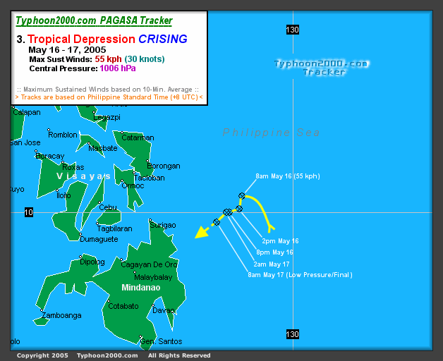
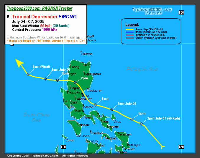