

Tropical Cyclone Formation Alert
Encyclopedia
United States Navy
The United States Navy is the naval warfare service branch of the United States Armed Forces and one of the seven uniformed services of the United States. The U.S. Navy is the largest in the world; its battle fleet tonnage is greater than that of the next 13 largest navies combined. The U.S...
-operated Joint Typhoon Warning Center
Joint Typhoon Warning Center
The Joint Typhoon Warning Center is a joint United States Navy – United States Air Force task force located at the Naval Maritime Forecast Center in Pearl Harbor, Hawaii...
in Honolulu, Hawaii
Honolulu, Hawaii
Honolulu is the capital and the most populous city of the U.S. state of Hawaii. Honolulu is the southernmost major U.S. city. Although the name "Honolulu" refers to the urban area on the southeastern shore of the island of Oahu, the city and county government are consolidated as the City and...
or the Naval Maritime Forecast Center in Norfolk, Virginia
Norfolk, Virginia
Norfolk is an independent city in the Commonwealth of Virginia in the United States. With a population of 242,803 as of the 2010 Census, it is Virginia's second-largest city behind neighboring Virginia Beach....
, warning of the possibility of a tropical cyclone
Tropical cyclone
A tropical cyclone is a storm system characterized by a large low-pressure center and numerous thunderstorms that produce strong winds and heavy rain. Tropical cyclones strengthen when water evaporated from the ocean is released as the saturated air rises, resulting in condensation of water vapor...
forming from a tropical disturbance that has been monitored. Such alerts are generally always issued when it is fairly certain that a tropical cyclone will form and are not always released prior to cyclone genesis, particularly if the cyclone appears suddenly. The TCFA consists of several different checks that are performed by the on-duty meteorologist of the system and its surroundings. If the condition being checked is met, a certain amount of points are given to the system.
Section 1
The first section of the TCFA contains information on the area of the alert as well as the estimated center of the circulation. The estimated maximum sustained winds are provided as well.Section 2
The second section generally contains more specific information pertaining to the system. Information such as location relative to nearby cities or places of interest can usually be found in this section. Some of the reasoning for the issuance of the TCFA, which usually consists of recent changes in the system, can be found here. The section always ends with a statement as to the potential for development, which the JTWCJoint Typhoon Warning Center
The Joint Typhoon Warning Center is a joint United States Navy – United States Air Force task force located at the Naval Maritime Forecast Center in Pearl Harbor, Hawaii...
will rank as either poor, fair, or good.
Section 3
This final section contains the time of the next bulletin on this system, which will update the system's progress over the elapsed time. The bulletin will be either another TCFA, a cancellation message, or the first advisory/warning on the system. The issuance of another TCFA would occur if the system remains in a state similar to its current state. A cancellation message would indicate that the likelihood of the system to develop into a tropical cyclone at the current time has decreased. An advisory would indicate that a tropical cyclone has indeed formed, and poses a future threat to the areas in the box defined in Section 1.Sample alert
MSGID/GENADMIN/NAVPACMETOCCEN PEARL HARBOR HI/JTWC//
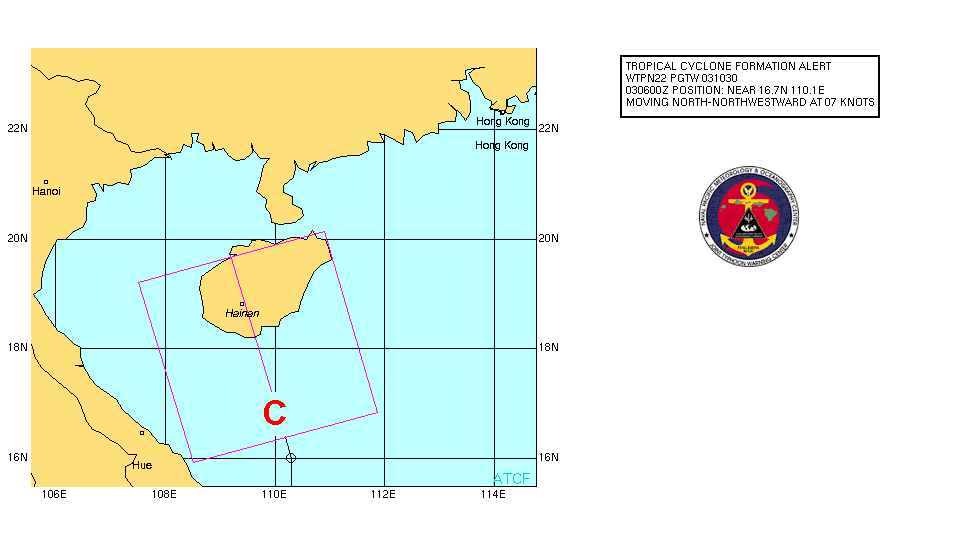
SUBJ/TROPICAL CYCLONE FORMATION ALERT 031021Z JUL 06//
RMKS
1. FORMATION OF A SIGNIFICANT TROPICAL CYCLONE IS POSSIBLE WITHIN
100 NM EITHER SIDE OF A LINE FROM 16.4N 110.2E TO 19.7N 109.2E
WITHIN THE NEXT 12 TO 24 HOURS. AVAILABLE DATA DOES NOT JUSTIFY
ISSUANCE OF NUMBERED TROPICAL CYCLONE WARNINGS AT THIS TIME.
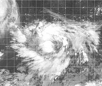
WINDS IN THE AREA ARE ESTIMATED TO BE 20 TO 25 KNOTS. METSAT IMAGERY
AT 030900Z INDICATES THAT A CIRCULATION CENTER IS LOCATED
NEAR 16.7N 110.1E. THE SYSTEM IS MOVING NORTH-NORTHWESTWARD AT
07 KNOTS.
2. REMARKS: THE AREA OF CONVECTION PREVIOUSLY LOCATED NEAR 16.3N
110.2E, IS NOW LOCATED NEAR 16.7N 110.1E, APPROXIMATELY 130 NM SOUTH-
SOUTHEAST OF HAINAN, CHINA. RECENT ANIMATED INFRARED IMAGERY SHOWS
CONVECTION HAS CONTINUED TO BECOME MORE CONSOLIDATED AND THERE IS NOW
NORTHERLY RETURN FLOW IN THE NORTHWESTERN QUADRANT OF SYSTEM. UPPER
LEVEL ANALYSIS INDICATES FAVORABLE EQUATORWARD OUTFLOW AND MODERATE
VERTICAL WIND SHEAR. MAXIMUM SUSTAINED SURFACE WINDS ARE ESTIMATED AT
20 TO 25 KNOTS. MINIMUM SEA LEVEL PRESSURE IS ESTIMATED TO BE NEAR
1003 MB. THE POTENTIAL FOR THE DEVELOPMENT OF A SIGNIFICANT TROPICAL
CYCLONE WITHIN THE NEXT 24 HOURS IS UPGRADED TO GOOD.
3. THIS ALERT WILL BE REISSUED, UPGRADED TO WARNING OR CANCELLED
BY 041030Z.//
Issuance checklist
The JTWC and NMFC follow a checklist when deciding whether or not to issue a TCFA on tropical disturbances. The checklist is updated every few years, and the JTWC checklist may differ slightly from the NLMOC checklist, which is shown below. If a system gets 35 to 38 points, a TCFA may be issued depending on DvorakDvorak technique
The Dvorak technique is a widely used system to subjectively estimate tropical cyclone intensity based solely on visible and infrared satellite images. Several agencies issue Dvorak intensity numbers for cyclones of sufficient intensity...
trends, and if a system gets 39 points or more a TCFA should be issued.
Surface
| Condition | Points |
|---|---|
| A circulation is evident using visible satellite, shortwave infrared, microwave imagery or QuikSCAT QuikSCAT The QuikSCAT is an earth-observing satellite that provided estimates of wind speed and direction over the oceans to National Oceanic and Atmospheric Administration and others. This "quick recovery" mission intended to replace the NASA Scatterometer , which failed in June 1997... /Windsat ambiguities |
|
| A circulation has been evident for at least 24 hours | |
| A westerly surface- or gradient-level wind of 5 kt that is within 200 nm Nautical mile The nautical mile is a unit of length that is about one minute of arc of latitude along any meridian, but is approximately one minute of arc of longitude only at the equator... (370 km, 230 mi) south of the centre of the disturbance |
|
| Any wind associated with the system is at least 20 kt | |
| Any wind associated with the system is at least 25 kt | |
| Any wind associated with the system is at least 30 kt | |
| A weather station Weather station A weather station is a facility, either on land or sea, with instruments and equipment for observing atmospheric conditions to provide information for weather forecasts and to study the weather and climate. The measurements taken include temperature, barometric pressure, humidity, wind speed, wind... within 200 nm of the system has reported had a pressure drop of 2 mb Bar (unit) The bar is a unit of pressure equal to 100 kilopascals, and roughly equal to the atmospheric pressure on Earth at sea level. Other units derived from the bar are the megabar , kilobar , decibar , centibar , and millibar... over 24 hours |
|
| A weather station within 200 nm of the system has had a pressure drop of 3 mb over 24 hours | |
| The estimated MSLP Atmospheric pressure Atmospheric pressure is the force per unit area exerted into a surface by the weight of air above that surface in the atmosphere of Earth . In most circumstances atmospheric pressure is closely approximated by the hydrostatic pressure caused by the weight of air above the measurement point... of the system is less than 1010 to 1009 mb |
|
| The estimated MSLP of the system is 1008 mb or less |
500 mb height
| Condition | Points |
|---|---|
| There is evidence of at least an inverted trough Trough (meteorology) A trough is an elongated region of relatively low atmospheric pressure, often associated with fronts.Unlike fronts, there is not a universal symbol for a trough on a weather chart. The weather charts in some countries or regions mark troughs by a line. In the United States, a trough may be marked... |
|
| There is evidence of a closed circulation in the system |
200 mb height
| Condition | Points |
|---|---|
| Westerly flow West wind A west wind is a wind that blows from the west, in an eastward direction. In Western tradition, it has usually been considered the mildest and most favorable of the directional winds.... of at least 15 kt over the disturbance |
|
| There is evidence of anticyclonic Anticyclone An anticyclone is a weather phenomenon defined by the United States' National Weather Service's glossary as "[a] large-scale circulation of winds around a central region of high atmospheric pressure, clockwise in the Northern Hemisphere, counterclockwise in the Southern Hemisphere"... outflow over the centre of the disturbance |
|
| Easterly flow East wind An east wind is a wind that originates in the east and blows west. In Greek mythology, Eurus, the east wind, was the only wind not associated with any of the three Greek seasons, and is the only one of these four Anemoi not mentioned in Hesiod's Theogony or in the Orphic Hymns.-Biblical... of at most 20 kt over the disturbance |
Sea surface temperature
| Condition | Points |
|---|---|
| The sea surface temperature Sea surface temperature Sea surface temperature is the water temperature close to the oceans surface. The exact meaning of surface varies according to the measurement method used, but it is between and below the sea surface. Air masses in the Earth's atmosphere are highly modified by sea surface temperatures within a... is 26 Celsius Celsius Celsius is a scale and unit of measurement for temperature. It is named after the Swedish astronomer Anders Celsius , who developed a similar temperature scale two years before his death... (78.8 Fahrenheit Fahrenheit Fahrenheit is the temperature scale proposed in 1724 by, and named after, the German physicist Daniel Gabriel Fahrenheit . Within this scale, the freezing of water into ice is defined at 32 degrees, while the boiling point of water is defined to be 212 degrees... ) or higher |
Satellite data
| Condition | Points |
|---|---|
| The system has persisted for at least 24 hours | |
| The system has persisted for at least 48 hours | |
| The system has persisted for at least 72 hours | |
| The system has a Dvorak Dvorak technique The Dvorak technique is a widely used system to subjectively estimate tropical cyclone intensity based solely on visible and infrared satellite images. Several agencies issue Dvorak intensity numbers for cyclones of sufficient intensity... classification of T1.0 to T1.5 from all three agencies (TAFB, SAB Satellite Analysis Branch The Satellite Analysis Branch, part of NESDIS' Satellite Services Division, is the operational focal point for real-time imagery products within NESDIS... , AFWA Air Force Weather Agency The Air Force Weather Agency is a Field Operating Agency and the lead military meteorology center of the United States Air Force... ) |
|
| The system has a Dvorak classification of T1.5 to T2.0 from all three agencies | |
| The Dvorak final-T number has decreased by T0.5 to T1.0 from two or more agencies |
Miscellaneous
| Condition | Points |
|---|---|
| The cloud system is at least 5 degrees latitude Latitude In geography, the latitude of a location on the Earth is the angular distance of that location south or north of the Equator. The latitude is an angle, and is usually measured in degrees . The equator has a latitude of 0°, the North pole has a latitude of 90° north , and the South pole has a... away from the equator Equator An equator is the intersection of a sphere's surface with the plane perpendicular to the sphere's axis of rotation and containing the sphere's center of mass.... |
|
| The tropical system is within 72 hours of reaching a Department of Defense United States Department of Defense The United States Department of Defense is the U.S... resource |
|
| The cloud system center and the satellite centre fixes for the system are within 2 degrees of each other |
See also
- National Hurricane CenterNational Hurricane CenterThe National Hurricane Center , located at Florida International University in Miami, Florida, is the division of the National Weather Service responsible for tracking and predicting weather systems within the tropics between the Prime Meridian and the 140th meridian west poleward to the 30th...
, which normally issues advisories without a TCFA being issued if certain conditions are met.