
2004-05 South-West Indian Ocean cyclone season
Encyclopedia
The 2004-05 South-West Indian Ocean
cyclone season was an annual event of tropical cyclone
formation. It started on November 15, 2004 and ended on April 30, 2005. For Mauritius
and the Seychelles
, the season continued until May 15. These dates conventionally delimit the period of each year when most tropical cyclones form in the basin, which is west of 90°E
and south of the Equator
. Tropical cyclones in this basin are monitored by the Regional Specialised Meteorological Centre in Réunion
.
developed near the edge of Météo-France
's area of responsibility within an unseasonably active monsoon
al band which coincided with the Madden-Julian oscillation
. Tracking towards the southeast, the low experience strong deep-level wind shear
which kept most of the convection
displaced from the center of circulation
. On August 31, convection managed to develop around the west and southwestern portions of the low before and was designated as Tropical Depression 01. The depression reached its peak intensity at this time with winds of 55 km/h (35 mph 10-minute winds) and a minimum pressure of 999 hPa
(mbar
). Shortly after, the depression entered Australian Bureau of Meteorology in Perth's area of responsibility. The depression later intensified into a tropical cyclone and was named Phoebe.
with winds of 25 knots (49 km/h) on October 25, while JTWC designated the storm as 02S. The storm moved westward, strengthening to 30 knots (58.8 km/h) sustained winds. The JTWC classified the storm as 35 knots (69 km/h) tropical storm. The storm weakened to a 25 knots (49 km/h) disturbance before making landfall near Dar es Salaam
, Tanzania
, on October 29.
on January 4. The depression moved southeastward, making landfall in western Madagascar
between Morombe
and Toliara
. It dissipated that same day.
.
, Madagascar
, with 40 knots (78.4 km/h) winds. As the storm moved into the Mozambique Channel
, it intensified rapidly reaching 65 knots (127 km/h) winds in 12 hours. After the intensity leveled off, the storm went through a rapid intensification a second time, reaching 90 knots (176.4 km/h) winds as it moved southward through the channel. Ernest turned to the southeast and began to slowly weaken as it neared the southern end of the channel. Ernest moved along the coastline of Madagascar on January 22 with 70 knots (137.2 km/h) sustained winds. After passing the island, Ernest accelerated out to sea and became extratropical on January 24. Tropical Cyclone Ernest brought significant rainfall to southern Madagascar. Just five days later, Tropical Storm Felapi affected the same area. 19 people died, 214 were missing, and 32,000 were homeless following the two storms.
, then the Sub-regional Tropical Cyclone Advisory Centre in Madagascar
assigns the appropriate name to the storm. If a tropical disturbance reaches moderate tropical storm status between 55°E
and 90°E
, then the Sub-regional Tropical Cyclone Advisory Centre in Mauritius
assigns the appropriate name to the storm. A new annual list is used every year so no names are retired.
Indian Ocean
The Indian Ocean is the third largest of the world's oceanic divisions, covering approximately 20% of the water on the Earth's surface. It is bounded on the north by the Indian Subcontinent and Arabian Peninsula ; on the west by eastern Africa; on the east by Indochina, the Sunda Islands, and...
cyclone season was an annual event of tropical cyclone
Tropical cyclone
A tropical cyclone is a storm system characterized by a large low-pressure center and numerous thunderstorms that produce strong winds and heavy rain. Tropical cyclones strengthen when water evaporated from the ocean is released as the saturated air rises, resulting in condensation of water vapor...
formation. It started on November 15, 2004 and ended on April 30, 2005. For Mauritius
Mauritius
Mauritius , officially the Republic of Mauritius is an island nation off the southeast coast of the African continent in the southwest Indian Ocean, about east of Madagascar...
and the Seychelles
Seychelles
Seychelles , officially the Republic of Seychelles , is an island country spanning an archipelago of 115 islands in the Indian Ocean, some east of mainland Africa, northeast of the island of Madagascar....
, the season continued until May 15. These dates conventionally delimit the period of each year when most tropical cyclones form in the basin, which is west of 90°E
90th meridian east
The meridian 90° east of Greenwich is a line of longitude that extends from the North Pole across the Arctic Ocean, Asia, the Indian Ocean, the Southern Ocean, and Antarctica to the South Pole.The Ninety East Ridge is named after the meridian....
and south of the Equator
Equator
An equator is the intersection of a sphere's surface with the plane perpendicular to the sphere's axis of rotation and containing the sphere's center of mass....
. Tropical cyclones in this basin are monitored by the Regional Specialised Meteorological Centre in Réunion
Réunion
Réunion is a French island with a population of about 800,000 located in the Indian Ocean, east of Madagascar, about south west of Mauritius, the nearest island.Administratively, Réunion is one of the overseas departments of France...
.
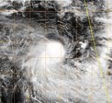
Tropical Depression 01 (Phoebe)
On August 30, an area of low pressureLow pressure area
A low-pressure area, or "low", is a region where the atmospheric pressure at sea level is below that of surrounding locations. Low-pressure systems form under areas of wind divergence which occur in upper levels of the troposphere. The formation process of a low-pressure area is known as...
developed near the edge of Météo-France
Météo-France
Météo-France is the French national meteorological service.The organisation was established by decree in June 1993 and is a department of the Ministry of Transportation. It is headquartered in Paris but many domestic operations have been decentralised to Toulouse...
's area of responsibility within an unseasonably active monsoon
Monsoon
Monsoon is traditionally defined as a seasonal reversing wind accompanied by corresponding changes in precipitation, but is now used to describe seasonal changes in atmospheric circulation and precipitation associated with the asymmetric heating of land and sea...
al band which coincided with the Madden-Julian oscillation
Madden-Julian oscillation
The Madden–Julian oscillation ' is the largest element of the intraseasonal variability in the tropical atmosphere. It is a large-scale coupling between atmospheric circulation and tropical deep convection...
. Tracking towards the southeast, the low experience strong deep-level wind shear
Wind shear
Wind shear, sometimes referred to as windshear or wind gradient, is a difference in wind speed and direction over a relatively short distance in the atmosphere...
which kept most of the convection
Atmospheric convection
Atmospheric convection is the result of a parcel-environment instability, or temperature difference, layer in the atmosphere. Different lapse rates within dry and moist air lead to instability. Mixing of air during the day which expands the height of the planetary boundary layer leads to...
displaced from the center of circulation
Eye (cyclone)
The eye is a region of mostly calm weather found at the center of strong tropical cyclones. The eye of a storm is a roughly circular area and typically 30–65 km in diameter. It is surrounded by the eyewall, a ring of towering thunderstorms where the second most severe weather of a cyclone...
. On August 31, convection managed to develop around the west and southwestern portions of the low before and was designated as Tropical Depression 01. The depression reached its peak intensity at this time with winds of 55 km/h (35 mph 10-minute winds) and a minimum pressure of 999 hPa
Pascal (unit)
The pascal is the SI derived unit of pressure, internal pressure, stress, Young's modulus and tensile strength, named after the French mathematician, physicist, inventor, writer, and philosopher Blaise Pascal. It is a measure of force per unit area, defined as one newton per square metre...
(mbar
Bar (unit)
The bar is a unit of pressure equal to 100 kilopascals, and roughly equal to the atmospheric pressure on Earth at sea level. Other units derived from the bar are the megabar , kilobar , decibar , centibar , and millibar...
). Shortly after, the depression entered Australian Bureau of Meteorology in Perth's area of responsibility. The depression later intensified into a tropical cyclone and was named Phoebe.
Tropical Depression 02
Tropical Depression 02R developed 675 nautical miles (1,250 km) west of Diego GarciaDiego Garcia
Diego Garcia is a tropical, footprint-shaped coral atoll located south of the equator in the central Indian Ocean at 7 degrees, 26 minutes south latitude. It is part of the British Indian Ocean Territory [BIOT] and is positioned at 72°23' east longitude....
with winds of 25 knots (49 km/h) on October 25, while JTWC designated the storm as 02S. The storm moved westward, strengthening to 30 knots (58.8 km/h) sustained winds. The JTWC classified the storm as 35 knots (69 km/h) tropical storm. The storm weakened to a 25 knots (49 km/h) disturbance before making landfall near Dar es Salaam
Dar es Salaam
Dar es Salaam , formerly Mzizima, is the largest city in Tanzania. It is also the country's richest city and a regionally important economic centre. Dar es Salaam is actually an administrative province within Tanzania, and consists of three local government areas or administrative districts: ...
, Tanzania
Tanzania
The United Republic of Tanzania is a country in East Africa bordered by Kenya and Uganda to the north, Rwanda, Burundi, and the Democratic Republic of the Congo to the west, and Zambia, Malawi, and Mozambique to the south. The country's eastern borders lie on the Indian Ocean.Tanzania is a state...
, on October 29.
Severe Tropical Storm Arola
Tropical Cyclone Arola developed from Tropical Depression 03R on November 8 approximately 400 nautical miles (740.8 km) east-southeast of Diego Garcia with 45 knots (88 km/h) winds. The storm moved west-southwest as it continued to intensify, reaching its peak intensity of 60 knots (117.6 km/h). The storm drifted westward as it weakened over the open waters never affecting land.Intense Tropical Cyclone Bento
Tropical Cyclone Bento developed from Tropical Depression 04S on November 21 approximately 375 nautical miles (695 km) east-southeast of Diego Garcia with 40 knots (78.4 km/h) winds. The storm continued to intensify, reaching cyclone status on November 22. Bento reached its peak intensity of 120 knots (235.2 km/h) on the 22nd, 175 nautical miles (324 km) east-southeast of Diego Garcia. Bento is the first South Indian tropical cyclone of this intensity located this close to the equator. Bento tracked to the west-southwest as it slowly began to weaken from its peak intensity. On November 25 the winds had dropped to 70 knots (137.2 km/h), and the storm was downgraded to a tropical storm. The storm weakened to a tropical depression on November 30, 615 nautical miles (1,139 km) south of Diego Garcia.Tropical Cyclone Chambo
Tropical Cyclone Chambo developed from Tropical Depression 06S on December 24, 750 nautical miles (1,389 km) west of the Cocos Islands and moving southwestward with 40 knots (78.4 km/h) winds. The system reached cyclone intensity the following day. The storm reached a peak intensity of 85 knots (167 km/h) on December 27. The storm continued on a southwestern track over the open waters, becoming extratropical on December 30.Tropical Depression 07
Tropical Depression 07 formed in the Mozambique ChannelMozambique Channel
The Mozambique Channel is a portion of the Indian Ocean located between the island nation of Madagascar and southeast Africa, primarily the country of Mozambique. It was a World War II clashpoint during the Battle of Madagascar...
on January 4. The depression moved southeastward, making landfall in western Madagascar
Madagascar
The Republic of Madagascar is an island country located in the Indian Ocean off the southeastern coast of Africa...
between Morombe
Morombe
Morombe is a coastal city in Atsimo-Andrefana Region, Madagascar. It is located at around and can be reached by pirogue from Morondava.- Literatur :...
and Toliara
Toliara
-References:...
. It dissipated that same day.
Severe Tropical Storm Daren
Tropical Storm Daren developed from Tropical Depression 11S (09M) on January 19, 450 nautical miles (833.4 km) south-southeast of Diego Garcia with winds of 40 knots (78.4 km/h). This would be the storm's peak intensity as it moved to the west-southwest. Increasing vertical wind shear would eventually cause the storm to weaken. The storm dissipated on January 22 150 nautical miles (277.8 km) north of MauritiusMauritius
Mauritius , officially the Republic of Mauritius is an island nation off the southeast coast of the African continent in the southwest Indian Ocean, about east of Madagascar...
.
Intense Tropical Cyclone Ernest
Tropical Cyclone Ernest developed from Tropical Depression 12S (08M) on January 20, 400 nautical miles (740.8 km) north-northwest of AntananarivoAntananarivo
Antananarivo , formerly Tananarive , is the capital and largest city in Madagascar. It is also known by its French colonial shorthand form Tana....
, Madagascar
Madagascar
The Republic of Madagascar is an island country located in the Indian Ocean off the southeastern coast of Africa...
, with 40 knots (78.4 km/h) winds. As the storm moved into the Mozambique Channel
Mozambique Channel
The Mozambique Channel is a portion of the Indian Ocean located between the island nation of Madagascar and southeast Africa, primarily the country of Mozambique. It was a World War II clashpoint during the Battle of Madagascar...
, it intensified rapidly reaching 65 knots (127 km/h) winds in 12 hours. After the intensity leveled off, the storm went through a rapid intensification a second time, reaching 90 knots (176.4 km/h) winds as it moved southward through the channel. Ernest turned to the southeast and began to slowly weaken as it neared the southern end of the channel. Ernest moved along the coastline of Madagascar on January 22 with 70 knots (137.2 km/h) sustained winds. After passing the island, Ernest accelerated out to sea and became extratropical on January 24. Tropical Cyclone Ernest brought significant rainfall to southern Madagascar. Just five days later, Tropical Storm Felapi affected the same area. 19 people died, 214 were missing, and 32,000 were homeless following the two storms.
Moderate Tropical Storm Felapi
Tropical Storm Felapi developed from Tropical Depression 11M on January 27, 115 nautical miles (213 km) northwest of Tulear. The storm moved southeastward where it made landfall in southwestern Madagascar on January 28. The storm was downgraded to a tropical depression as it moved over the southern portion of the island. The storm emerged in the South Indian Ocean on January 29, making a turn to the east, then northeast over the open waters. Felapi turned back to the southeast as a subtropical depression. See the Tropical Cyclone Ernest section above for fatalities associated with Tropical Storm Felapi.Severe Tropical Storm Gerard
Formed on January 28, became extratropical on February 5, 2005. Reached peak intensity of 60 knots (117.6 km/h).Tropical Depression 13
Formed on February 4, became extratropical on February 8, 2005.Severe Tropical Storm Hennie
Formed on March 21, became extratropical on March 27 and Reunion centre stopped issuing advisories on March 29, 2005. Reached peak intensity of 55 knots (108 km/h).- Tropical Cyclone 2005's tracking chart of Tropical Cyclone Hennie.
Severe Tropical Storm Isang
Formed on March 29, became extratropical on April 7, 2005. Reached peak intensity of 60 knots (117.6 km/h).Very Intense Tropical Cyclone Adeline-Juliet
The cyclone formed in Perth's area of responsibility (AOR) on April 1 and entered Reunion's AOR on April 5. It became extratropical on April 12. This would be the last very intense tropical cyclone until Edzani in 2010.Storm names
A tropical disturbance is named when it reaches moderate tropical storm strength. If a tropical disturbance reaches moderate tropical storm status west of 55°E55th meridian east
The meridian 55° east of Greenwich is a line of longitude that extends from the North Pole across the Arctic Ocean, Europe, Asia, the Indian Ocean, the Southern Ocean, and Antarctica to the South Pole....
, then the Sub-regional Tropical Cyclone Advisory Centre in Madagascar
Madagascar
The Republic of Madagascar is an island country located in the Indian Ocean off the southeastern coast of Africa...
assigns the appropriate name to the storm. If a tropical disturbance reaches moderate tropical storm status between 55°E
55th meridian east
The meridian 55° east of Greenwich is a line of longitude that extends from the North Pole across the Arctic Ocean, Europe, Asia, the Indian Ocean, the Southern Ocean, and Antarctica to the South Pole....
and 90°E
90th meridian east
The meridian 90° east of Greenwich is a line of longitude that extends from the North Pole across the Arctic Ocean, Asia, the Indian Ocean, the Southern Ocean, and Antarctica to the South Pole.The Ninety East Ridge is named after the meridian....
, then the Sub-regional Tropical Cyclone Advisory Centre in Mauritius
Mauritius
Mauritius , officially the Republic of Mauritius is an island nation off the southeast coast of the African continent in the southwest Indian Ocean, about east of Madagascar...
assigns the appropriate name to the storm. A new annual list is used every year so no names are retired.
|
|
See also
- Tropical cyclone scalesTropical cyclone scalesTropical systems are officially ranked on one of several tropical cyclone scales according to their maximum sustained winds and in what oceanic basin they are located...
- List of Southern Hemisphere tropical cyclone seasons
- Atlantic hurricane seasons: 20042004 Atlantic hurricane seasonThe 2004 Atlantic hurricane season officially began on June 1, 2004, and lasted until November 30, 2004. These dates conventionally delimit the period of each year when most tropical cyclones form in the Atlantic basin...
, 20052005 Atlantic hurricane seasonThe 2005 Atlantic hurricane season was the most active Atlantic hurricane season in recorded history, repeatedly shattering numerous records. The impact of the season was widespread and ruinous with an estimated 3,913 deaths and record damage of about $159.2 billion... - Pacific hurricane seasons: 20042004 Pacific hurricane seasonThe 2004 Pacific hurricane season officially started on May 15, 2004 in the eastern Pacific, and on June 1, 2004 in the central Pacific, and lasted until November 30, 2004...
, 20052005 Pacific hurricane seasonThe 2005 Pacific hurricane season officially began on May 15, 2005 in the eastern Pacific and on June 1, 2005 in the central Pacific, and lasted until November 30, 2005. These dates conventionally delimit the period of each year when most tropical cyclones form in the northeastern Pacific Ocean... - Pacific typhoon seasons: 20042004 Pacific typhoon seasonThe 2004 Pacific typhoon season has no official bounds; it ran year-round in 2004, but most tropical cyclones tend to form in the northwestern Pacific Ocean between May and November...
, 20052005 Pacific typhoon seasonThe 2005 Pacific typhoon season had no official bounds; it ran year-round in 2005, but most tropical cyclones tend to form in the northwestern Pacific Ocean between May and November... - North Indian Ocean cyclone seasons: 20042004 North Indian Ocean cyclone seasonThe 2004 North Indian Ocean cyclone season had no bounds, but cyclones tend to form between April and December, with peaks in May and November. These dates conventionally delimit the period of each year when most tropical cyclones form in the northern Indian Ocean.-Season summary:In 2004, RSMC New...
, 2005