

Atmospheric convection
Encyclopedia
Air parcel
In fluid dynamics, within the framework of continuum mechanics, a fluid parcel is a very small amount of fluid, identifiable throughout its dynamic history while moving with the fluid flow. As it moves, the mass of a fluid parcel remains constant, while—in a compressible flow—its volume may...
-environment instability, or temperature difference, layer in the atmosphere. Different lapse rates within dry and moist air lead to instability. Mixing of air during the day which expands the height of the planetary boundary layer
Planetary boundary layer
The planetary boundary layer , also known as the atmospheric boundary layer , is the lowest part of the atmosphere and its behavior is directly influenced by its contact with a planetary surface. On Earth it usually responds to changes in surface forcing in an hour or less...
leads to increased winds, cumulus cloud
Cumulus cloud
Cumulus clouds are a type of cloud with noticeable vertical development and clearly defined edges. Cumulus means "heap" or "pile" in Latin. They are often described as "puffy" or "cotton-like" in appearance. Cumulus clouds may appear alone, in lines, or in clusters...
development, and decreased surface dewpoints. Moist convection leads to thunderstorm
Thunderstorm
A thunderstorm, also known as an electrical storm, a lightning storm, thundershower or simply a storm is a form of weather characterized by the presence of lightning and its acoustic effect on the Earth's atmosphere known as thunder. The meteorologically assigned cloud type associated with the...
development, which is often responsible for severe weather
Severe weather
Severe weather phenomena are weather conditions that are hazardous to human life and property.- Examples Include :Severe weather can occur under a variety of situations, but three characteristics are generally needed: a temperature or moisture boundary, moisture, and , instability in the...
throughout the world. Special threats from thunderstorms include hail
Hail
Hail is a form of solid precipitation. It consists of balls or irregular lumps of ice, each of which is referred to as a hail stone. Hail stones on Earth consist mostly of water ice and measure between and in diameter, with the larger stones coming from severe thunderstorms...
, downburst
Downburst
A downburst is created by an area of significantly rain-cooled air that, after reaching ground level, spreads out in all directions producing strong winds. Unlike winds in a tornado, winds in a downburst are directed outwards from the point where it hits land or water...
s, and tornado
Tornado
A tornado is a violent, dangerous, rotating column of air that is in contact with both the surface of the earth and a cumulonimbus cloud or, in rare cases, the base of a cumulus cloud. They are often referred to as a twister or a cyclone, although the word cyclone is used in meteorology in a wider...
es.
Overview
There are a few general archetypeArchetype
An archetype is a universally understood symbol or term or pattern of behavior, a prototype upon which others are copied, patterned, or emulated...
s of atmospheric instability that correspond to convection and lack thereof. Steeper and/or positive lapse rate
Lapse rate
The lapse rate is defined as the rate of decrease with height for an atmospheric variable. The variable involved is temperature unless specified otherwise. The terminology arises from the word lapse in the sense of a decrease or decline; thus, the lapse rate is the rate of decrease with height and...
s (environmental air cools quickly with height) suggests atmospheric convection is more likely, while weaker and/or negative environmental lapse rates suggest it is less likely. This is because any displaced air parcels will become more (less) buoyant, given their sign of adiabatic temperature change, in the steep (weak) lapse rate environments.
Convection begins at the Level of Free Convection (LFC)
Level of free convection
The level of free convection is the altitude in the atmosphere where the temperature of the environment decreases faster than the moist adiabatic lapse rate of a saturated air parcel at the same level....
, where it begins its ascent through the Free Convective Layer (FCL)
Free convective layer
In atmospheric sciences, the free convective layer is the layer of conditional or potential instability in the troposphere. It is a layer of positive buoyancy and is the layer where deep, moist convection can occur. On an atmospheric sounding, it is the layer between the level of free...
, and then stops at the equilibrium level. The rising parcel, if having enough momentum, will continue to rise to the Maximum Parcel Level (MPL) until negative buoyancy decelerates the parcel to a stop.
As long as a parcel is convecting, it theoretically will be accelerating
Acceleration
In physics, acceleration is the rate of change of velocity with time. In one dimension, acceleration is the rate at which something speeds up or slows down. However, since velocity is a vector, acceleration describes the rate of change of both the magnitude and the direction of velocity. ...
. The exception to this is if drag produced by the updraft creates an equal, albeit opposite force to counter that from the buoyancy.http://www.flame.org/~cdoswell/publications/Overview_Chapter.pdf. This could be thought of as similar to the terminal velocity
Terminal velocity
In fluid dynamics an object is moving at its terminal velocity if its speed is constant due to the restraining force exerted by the fluid through which it is moving....
of a falling object. This force from buoyancy can be measured by Convective Available Potential Energy (CAPE), or the joules of energy available per kilogram of potentially buoyant air. A theoretical updraft velocity can be derived from this value via substitution into the kinetic energy equation
Kinetic energy
The kinetic energy of an object is the energy which it possesses due to its motion.It is defined as the work needed to accelerate a body of a given mass from rest to its stated velocity. Having gained this energy during its acceleration, the body maintains this kinetic energy unless its speed changes...
. Although this value will be an underestimation given the aforementioned drag
Drag (physics)
In fluid dynamics, drag refers to forces which act on a solid object in the direction of the relative fluid flow velocity...
or entrainment
Entrainment (meteorology)
Entrainment is a phenomenon of the atmosphere which occurs when a turbulent flow captures a non-turbulent flow. It is typically used to refer to the capture of a wind flow of high moisture content, or in the case of tropical cyclones, the capture of drier air....
effects holding back further acceleration at some point. See the CAPE
Convective available potential energy
In meteorology, convective available potential energy , sometimes, simply, available potential energy , is the amount of energy a parcel of air would have if lifted a certain distance vertically through the atmosphere...
, buoyancy
Buoyancy
In physics, buoyancy is a force exerted by a fluid that opposes an object's weight. In a column of fluid, pressure increases with depth as a result of the weight of the overlying fluid. Thus a column of fluid, or an object submerged in the fluid, experiences greater pressure at the bottom of the...
, and parcel
Air parcel
In fluid dynamics, within the framework of continuum mechanics, a fluid parcel is a very small amount of fluid, identifiable throughout its dynamic history while moving with the fluid flow. As it moves, the mass of a fluid parcel remains constant, while—in a compressible flow—its volume may...
links for a more in depth mathematical explanation of these processes.
Initiation
A thermal column (or thermal) is a vertical section of rising air in the lower altitudes of the Earth's atmosphere. Thermals are created by the uneven heating of the Earth's surface from solar radiation. The Sun warms the ground, which in turn warms the air directly above it. The warmer air expands, becoming less dense than the surrounding air mass, and creating a thermal lowThermal low
Thermal lows, or heat lows, are non-frontal low-pressure areas that occur over the continents in the subtropics such as near the Sonoran Desert, the Mexican plateau, Sahara, South America over northwest Argentina, Australia, the Iberian peninsula, and Tibetan plateau during the warm season as the...
. The mass of lighter air rises, and as it does, it cools due to its expansion at lower high-altitude pressures. It stops rising when it has cooled to the same temperature as the surrounding air. Associated with a thermal is a downward flow surrounding the thermal column. The downward moving exterior is caused by colder air being displaced at the top of the thermal. Another convection-driven weather effect is the sea breeze
Sea breeze
A sea-breeze is a wind from the sea that develops over land near coasts. It is formed by increasing temperature differences between the land and water; these create a pressure minimum over the land due to its relative warmth, and forces higher pressure, cooler air from the sea to move inland...
.
Thunderstorms
Warm air has a lower density than cool air, so warm air rises within cooler air, similar to hot air balloonHot air balloon
The hot air balloon is the oldest successful human-carrying flight technology. It is in a class of aircraft known as balloon aircraft. On November 21, 1783, in Paris, France, the first untethered manned flight was made by Jean-François Pilâtre de Rozier and François Laurent d'Arlandes in a hot air...
s. Clouds form as relatively warmer air carrying moisture rises within cooler air. As the moist air rises, it cools causing some of the water vapor
Water vapor
Water vapor or water vapour , also aqueous vapor, is the gas phase of water. It is one state of water within the hydrosphere. Water vapor can be produced from the evaporation or boiling of liquid water or from the sublimation of ice. Under typical atmospheric conditions, water vapor is continuously...
in the rising packet of air to condense
Condensation
Condensation is the change of the physical state of matter from gaseous phase into liquid phase, and is the reverse of vaporization. When the transition happens from the gaseous phase into the solid phase directly, the change is called deposition....
. When the moisture condenses, it releases energy known as latent heat
Latent heat
Latent heat is the heat released or absorbed by a chemical substance or a thermodynamic system during a process that occurs without a change in temperature. A typical example is a change of state of matter, meaning a phase transition such as the melting of ice or the boiling of water. The term was...
of fusion which allows the rising packet of air to cool less than its surrounding air, continuing the cloud's ascension. If enough instability
Convective available potential energy
In meteorology, convective available potential energy , sometimes, simply, available potential energy , is the amount of energy a parcel of air would have if lifted a certain distance vertically through the atmosphere...
is present in the atmosphere, this process will continue long enough for cumulonimbus clouds to form, which support lightning and thunder. Generally, thunderstorms require three conditions to form: moisture, an unstable airmass, and a lifting force (heat).
All thunderstorm
Thunderstorm
A thunderstorm, also known as an electrical storm, a lightning storm, thundershower or simply a storm is a form of weather characterized by the presence of lightning and its acoustic effect on the Earth's atmosphere known as thunder. The meteorologically assigned cloud type associated with the...
s, regardless of type, go through three stages: the developing stage, the mature stage, and the dissipation stage. The average thunderstorm has a 24 km (14.9 mi) diameter. Depending on the conditions present in the atmosphere, these three stages take an average of 30 minutes to go through.
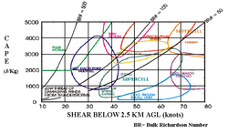
There are four main types of thunderstorms: single-cell, multicell, squall line (also called multicell line) and supercell. Which type forms depends on the instability and relative wind conditions at different layers of the atmosphere ("wind shear
Wind shear
Wind shear, sometimes referred to as windshear or wind gradient, is a difference in wind speed and direction over a relatively short distance in the atmosphere...
"). Single-cell thunderstorms form in environments of low vertical wind shear and last only 20–30 minutes. Organized thunderstorms and thunderstorm clusters/lines can have longer life cycles as they form in environments of significant vertical wind shear, which aids the development of stronger updrafts as well as various forms of severe weather. The supercell is the strongest of the thunderstorms, most commonly associated with large hail, high winds, and tornado formation.
The latent heat release from condensation is the determinate between significant convection and almost no convection at all. The fact that air is generally cooler during winter months, and therefore can not hold as much water vapor and associated latent heat, is why significant convection (thunderstorms) are infrequent in cooler areas during that period. Thundersnow
Thundersnow
Thundersnow, also known as a winter thunderstorm or a thunder snowstorm, is a relatively rare kind of thunderstorm with snow falling as the primary precipitation instead of rain. It typically falls in regions of strong upward motion within the cold sector of an extratropical cyclone...
is one situation where forcing mechanisms provide support for very steep environmental lapse rates, which as mentioned before is an archetype for favored convection. The small amount of latent heat released from air rising and condensing moisture in a thundersnow also serves to increase this convective potential, although minimally.
Boundaries and Forcing
Despite the fact that there might be a layer in the atmosphere that has positive values of CAPE, if the parcel does not reach or begin rising to that level, the most significant convection that occurs in the FCL will not be realized. This can occur for numerous reasons. Primarily, it is the result of a cap, or convective inhibition (CIN/CINH). Processes that can erode this inhibition are heating of the Earth's surface and forcing. Such forcing mechanisms encourage upward verticalvelocity, characterized by a speed that is relatively low to what you find in a thunderstorm updraft. Because of this, it is not the actual air being pushed to its LFC that "breaks through" the inhibition, but rather the forcing cools the inhibition adiabatically. This would counter, or "erode" the increase of temperature with height that is present during a capping inversion.
Forcing mechanisms that can lead to the eroding of inhibition are ones that create some sort of evacuation of mass in the upper parts of the atmosphere, or a surplus of mass in the low levels of the atmosphere, which would lead to upper level divergence or lower level convergence, respectively. Upward vertical motion will often follow. Specifically, a cold front
Cold front
A cold front is defined as the leading edge of a cooler mass of air, replacing a warmer mass of air.-Development of cold front:The cooler and denser air wedges under the less-dense warmer air, lifting it...
, sea/lake breeze
Sea breeze
A sea-breeze is a wind from the sea that develops over land near coasts. It is formed by increasing temperature differences between the land and water; these create a pressure minimum over the land due to its relative warmth, and forces higher pressure, cooler air from the sea to move inland...
, outflow boundary
Outflow boundary
An outflow boundary, also known as a gust front, is a storm-scale or mesoscale boundary separating thunderstorm-cooled air from the surrounding air; similar in effect to a cold front, with passage marked by a wind shift and usually a drop in temperature and a related pressure jump...
, or forcing through vorticity dynamics (differential positive vorticity advection
Positive vorticity advection
Positive vorticity advection, or PVA, is the result of more cyclonic values of vorticity advecting into lower values of vorticity. It is more generally referred to as "Cyclonic Vorticity Advection"...
) of the atmosphere such as with troughs, both shortwave
Shortwave (meteorology)
A shortwave or shortwave trough is an embedded kink in the trough / ridge pattern. This is the opposite of longwaves, which are responsible for synoptic scale systems, although shortwaves may be contained within or found ahead of longwaves and range from the mesocale to the synoptic scale...
and longwave
Rossby wave
Atmospheric Rossby waves are giant meanders in high-altitude winds that are a major influence on weather.They are not to be confused with oceanic Rossby waves, which move along the thermocline: that is, the boundary between the warm upper layer of the ocean and the cold deeper part of the...
. Jet streak
Jet stream
Jet streams are fast flowing, narrow air currents found in the atmospheres of some planets, including Earth. The main jet streams are located near the tropopause, the transition between the troposphere and the stratosphere . The major jet streams on Earth are westerly winds...
dynamics through the imbalance of Coriolis and pressure gradient forces, causing subgeostrophic and supergeostrophic flows
Geostrophic wind
The geostrophic wind is the theoretical wind that would result from an exact balance between the Coriolis effect and the pressure gradient force. This condition is called geostrophic balance. The geostrophic wind is directed parallel to isobars . This balance seldom holds exactly in nature...
, can also create upward vertical velocities.There are numerous other atmospheric setups in which upward vertical velocities can be created.
Concerns regarding severe deep moist convection
Buoyancy is key to thunderstorm growth and is necessary for any of the severe threats within a thunderstorm. There are other processes, not necessarily thermodynamic, that can increase updraft strength. These include updraft rotationMesocyclone
A mesocyclone is a vortex of air, approximately 2 to 10 miles in diameter , within a convective storm....
, low level convergence, and evacuation of mass out of the top of the updraft via strong upper level winds and the jet stream
Jet stream
Jet streams are fast flowing, narrow air currents found in the atmospheres of some planets, including Earth. The main jet streams are located near the tropopause, the transition between the troposphere and the stratosphere . The major jet streams on Earth are westerly winds...
.
Hail


Water
Water is a chemical substance with the chemical formula H2O. A water molecule contains one oxygen and two hydrogen atoms connected by covalent bonds. Water is a liquid at ambient conditions, but it often co-exists on Earth with its solid state, ice, and gaseous state . Water also exists in a...
and will freeze on contact with condensation nuclei. A cross-section through a large hailstone shows an onion-like structure. This means the hailstone is made of thick and translucent layers, alternating with layers that are thin, white and opaque. Former theory suggested that hailstones were subjected to multiple descents and ascents, falling into a zone of humidity and refreezing as they were uplifted. This up and down motion was thought to be responsible for the successive layers of the hailstone. New research (based on theory and field study) has shown this is not necessarily true.
The storm's updraft
Vertical draft
An updraft or downdraft is the vertical movement of air as a weather related phenomenon. One of two forces causes the air to move. Localized regions of warm or cool air will exhibit vertical movement. A mass of warm air will typically be less dense than the surrounding region, and so will rise...
, with upwardly directed wind speeds as high as 110 miles per hour (177 km/h), blow the forming hailstones up the cloud. As the hailstone ascends it passes into areas of the cloud where the concentration of humidity and supercooled water droplets varies. The hailstone’s growth rate changes depending on the variation in humidity and supercooled water droplets that it encounters. The accretion rate of these water droplets is another factor in the hailstone’s growth. When the hailstone moves into an area with a high concentration of water droplets, it captures the latter and acquires a translucent layer. Should the hailstone move into an area where mostly water vapour is available, it acquires a layer of opaque white ice.
Furthermore, the hailstone’s speed depends on its position in the cloud’s updraft and its mass. This determines the varying thicknesses of the layers of the hailstone. The accretion rate of supercooled water droplets onto the hailstone depends on the relative velocities between these water droplets and the hailstone itself. This means that generally the larger hailstones will form some distance from the stronger updraft where they can pass more time growing As the hailstone grows it releases latent heat
Latent heat
Latent heat is the heat released or absorbed by a chemical substance or a thermodynamic system during a process that occurs without a change in temperature. A typical example is a change of state of matter, meaning a phase transition such as the melting of ice or the boiling of water. The term was...
, which keeps its exterior in a liquid phase. Undergoing 'wet growth', the outer layer is sticky, or more adhesive, so a single hailstone may grow by collision with other smaller hailstones, forming a larger entity with an irregular shape.
The hailstone will keep rising in the thunderstorm until its mass can no longer be supported by the updraft. This may take at least 30 minutes based on the force of the updrafts in the hail-producing thunderstorm, whose top is usually greater than 10 km high. It then falls toward the ground while continuing to grow, based on the same processes, until it leaves the cloud. It will later begin to melt as it passes into air above freezing temperature
Thus, a unique trajectory in the thunderstorm is sufficient to explain the layer-like structure of the hailstone. The only case in which we can discuss multiple trajectories is in a multicellular thunderstorm where the hailstone may be ejected from the top of the "mother" cell and captured in the updraft of a more intense "daughter cell". This however is an exceptional case.
Downburst
A downburst is created by a column of sinking air that, after hitting ground level, spreads out in all directions and is capable of producing damaging straight-line winds of over 150 mph (240 km/h), often producing damage similar to, but distinguishable from, that caused by tornadoTornado
A tornado is a violent, dangerous, rotating column of air that is in contact with both the surface of the earth and a cumulonimbus cloud or, in rare cases, the base of a cumulus cloud. They are often referred to as a twister or a cyclone, although the word cyclone is used in meteorology in a wider...
es. This is because the physical properties of a downburst are completely different from those of a tornado. Downburst damage will radiate from a central point as the descending column spreads out when impacting the surface, whereas tornado damage tends towards convergent damage consistent with rotating winds. To differentiate between tornado damage and damage from a downburst, the term straight-line winds is applied to damage from microbursts.
Downbursts are particularly strong downdrafts from thunderstorms. Downbursts in air that is precipitation
Precipitation (meteorology)
In meteorology, precipitation In meteorology, precipitation In meteorology, precipitation (also known as one of the classes of hydrometeors, which are atmospheric water phenomena is any product of the condensation of atmospheric water vapor that falls under gravity. The main forms of precipitation...
free or contains virga
Virga
In meteorology, virga is an observable streak or shaft of precipitation that falls from a cloud but evaporates before reaching the ground. At high altitudes the precipitation falls mainly as ice crystals before melting and finally evaporating; this is usually due to compressional heating, because...
are known as dry downbursts; those accompanied with precipitation are known as wet downbursts. Most downbursts are less than 2.5 miles (4 km) in extent: these are called microburst
Microburst
A microburst is a very localized column of sinking air, producing damaging divergent and straight-line winds at the surface that are similar to, but distinguishable from, tornadoes, which generally have convergent damage. There are two types of microbursts: wet microbursts and dry microbursts...
s. Downbursts larger than 2.5 miles (4 km) in extent are sometimes called macrobursts. Downbursts can occur over large areas. In the extreme case, a derecho
Derecho
A derecho is a widespread and long-lived, violent convectively induced straight-line windstorm that is associated with a fast-moving band of severe thunderstorms in the form of a squall line usually taking the form of a bow echo...
can cover a huge area more than 200 miles (320 km) wide and over 1000 miles (1600 km) long, lasting up to 12 hours or more, and is associated with some of the most intense straight-line winds, but the generative process is somewhat different from that of most downbursts.
Tornadoes

Cumulonimbus cloud
Cumulonimbus is a towering vertical cloud that is very tall, dense, and involved in thunderstorms and other inclement weather. Cumulonimbus originates from Latin: Cumulus "Heap" and nimbus "rain". It is a result of atmospheric instability. These clouds can form alone, in clusters, or along a cold...
(thundercloud) or a cumulus cloud
Cumulus cloud
Cumulus clouds are a type of cloud with noticeable vertical development and clearly defined edges. Cumulus means "heap" or "pile" in Latin. They are often described as "puffy" or "cotton-like" in appearance. Cumulus clouds may appear alone, in lines, or in clusters...
, in rare cases. Tornadoes come in many sizes but typically form a visible condensation funnel
Funnel cloud
A funnel cloud is a funnel-shaped cloud of condensed water droplets, associated with a rotating column of wind and extending from the base of a cloud but not reaching the ground or a water surface. A funnel cloud is usually visible as a cone-shaped or needle like protuberance from the main cloud...
whose narrowest end reaches the earth and surrounded by a cloud of debris
Debris
Debris is rubble, wreckage, ruins, litter and discarded garbage/refuse/trash, scattered remains of something destroyed, or, in geology, large rock fragments left by a melting glacier etc. The singular form of debris is debris...
and dust
Dust
Dust consists of particles in the atmosphere that arise from various sources such as soil dust lifted up by wind , volcanic eruptions, and pollution...
.
Tornadoes wind speeds generally average between 40 miles per hour (64.4 km/h) and 110 miles per hour (177 km/h). They are approximately 250 feet (76.2 m) across and travel a few miles (kilometers) before dissipating. Some attain wind speeds in excess of 300 miles per hour (482.8 km/h), may stretch more than a mile (1.6 km) across, and maintain contact with the ground for dozens of miles (more than 100 km).
Tornadoes, despite being one of the most destructive weather phenomena are generally short-lived. A long-lived tornado generally lasts no more than an hour, but some have been known to last for 2 hours or longer (for example, the Tri-state tornado
Tri-State Tornado
The Tri-State Tornado of Wednesday, March 18, 1925, was the deadliest tornado in U.S. history. With 695 confirmed fatalities, the tornado killed more than twice as many as the second deadliest, the 1840 Great Natchez Tornado...
). Due to their relatively short duration, less information is known about the development and formation of tornadoes.
Measurement
The potential for convection in the atmosphere is often measured by an atmospheric temperature/dewpoint profile with height. This is often displayed on a Skew-TSkew-T log-P diagram
A Skew-T Log-P diagram is one of four thermodynamic diagrams commonly used in weather analysis and forecasting. In 1947, N. Herlofson proposed a modification to the emagram which allows straight, horizontal isobars, and provides for a large angle between isotherms and dry adiabats, similar to that...
chart or other similar thermodynamic diagram. These can be plotted by a measured sounding analysis
Atmospheric sounding
An atmospheric sounding is a measurement of vertical distribution of physical properties of the atmospheric column such as pressure, temperature, wind speed and wind direction , liquid water content, ozone concentration, pollution, and other properties...
, which is the sending of a radiosonde
Radiosonde
A radiosonde is a unit for use in weather balloons that measures various atmospheric parameters and transmits them to a fixed receiver. Radiosondes may operate at a radio frequency of 403 MHz or 1680 MHz and both types may be adjusted slightly higher or lower as required...
attached to a balloon into the atmosphere to take the measurements with height. Forecast models
Atmospheric model
An atmospheric model is a mathematical model constructed around the full set of primitive dynamical equations which govern atmospheric motions. It can supplement these equations with parameterizations for turbulent diffusion, radiation, moist processes , heat exchange, soil, vegetation, surface...
can also create these diagrams, but are less accurate due to model uncertainties and biases, and have lower spatial resolution. Although, the temporal resolution of forecast model soundings is greater than the direct measurements, where the former can have plots for intervals of up to every 3 hours, and the latter as having only 2 per day (although when a convective event is expected a special sounding might be taken outside of the normal schedule of 00Z and then 12Z.).http://www.stormchaser.niu.edu/machine/fcstsound.html