

Roadgeek
Encyclopedia
Road
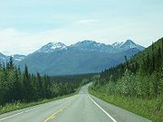
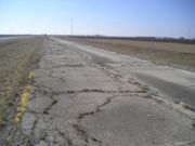
A road is a thoroughfare, route, or way on land between two places, which typically has been paved or otherwise improved to allow travel by some conveyance, including a horse, cart, or motor vehicle. Roads consist of one, or sometimes two, roadways each with one or more lanes and also any...
s, and especially going on road trip
Road trip
A road trip is any journey taken on roads, regardless of stops en route. Typically, road trips are long distances traveled by automobile.-Pre-automobile road trips:...
s, as a hobby
Hobby
A hobby is a regular activity or interest that is undertaken for pleasure, typically done during one's leisure time.- Etymology :A hobby horse is a wooden or wickerwork toy made to be ridden just like a real horse...
. A person with such an interest is also referred to as a road buff, roadfan or Roads Scholar, the latter being a play on the term Rhodes Scholar
Rhodes Scholarship
The Rhodes Scholarship, named after Cecil Rhodes, is an international postgraduate award for study at the University of Oxford. It was the first large-scale programme of international scholarships, and is widely considered the "world's most prestigious scholarship" by many public sources such as...
.
Interest
Roadgeeks view their interest as an appreciation of engineering and planning feats:
Cartography
Cartography is the study and practice of making maps. Combining science, aesthetics, and technique, cartography builds on the premise that reality can be modeled in ways that communicate spatial information effectively.The fundamental problems of traditional cartography are to:*Set the map's...
and map design. Enthusiasts may focus on a single activity related to roads, such as driving
Driving
Driving is the controlled operation and movement of a land vehicle, such as a car, truck or bus.Although direct operation of a bicycle and a mounted animal are commonly referred to as riding, such operators are legally considered drivers and are required to obey the rules of the road...
the full length of the highway system in a specific area, researching the history, planning and quirks of a particular road or national highway system. They occasionally are quoted in the press on topics related to the history of roads. Sometimes, road geeks are called "highway historians" for the knowledge and interests.
Even the numbering system can be a subject of deep interest, as Joe Moran describes in his book "On Roads: A Hidden History":
Activity
Example activities include:- Creating fonts and other graphic elements to share with other enthusiasts

- Taking road tripRoad tripA road trip is any journey taken on roads, regardless of stops en route. Typically, road trips are long distances traveled by automobile.-Pre-automobile road trips:...
s for the roads rather than for the destination, sometimes referred to as roadgeeking or Roads Scholaring - Comparing the extent of their travels with other enthusiasts, such as the number of Interstate Highway sections that have been wholly traveled.
- Photography of road signs, bridges or various highway artefacts
- Collecting old road mapMapA map is a visual representation of an area—a symbolic depiction highlighting relationships between elements of that space such as objects, regions, and themes....
s - Writing about the history of highways, highway terminology and the design of graphics or fonts to facilitate the work of others.
Roadgeeking online
In 2002, the St. Louis Post-DispatchSt. Louis Post-Dispatch
The St. Louis Post-Dispatch is the major city-wide newspaper in St. Louis, Missouri. Although written to serve Greater St. Louis, the Post-Dispatch is one of the largest newspapers in the Midwestern United States, and is available and read as far west as Kansas City, Missouri, as far south as...
reported that road enthusiasm was an Internet phenomenon. There is a Usenet
Usenet
Usenet is a worldwide distributed Internet discussion system. It developed from the general purpose UUCP architecture of the same name.Duke University graduate students Tom Truscott and Jim Ellis conceived the idea in 1979 and it was established in 1980...
newsgroup, misc.transport.road, where participants discuss all facets of roads and road trips from "construction projects to quirks and inconsistencies in signage". These individuals who anticipated each Rand McNally
Rand McNally
Rand McNally is an American publisher of maps, atlases, textbooks, and globes for travel, reference, commercial, and educational uses. It also provides online consumer street maps and directions, as well as commercial transportation routing software and mileage data...
road atlas release each year found a community of others online who were also interested in roads as a hobby. These communities of people could share photos, swap their thoughts on the highways in their areas and "debate the finer points of interchange design."
SABRE
Started in 1999, the Society for All British and Irish Road Enthusiasts (SABRE), originally known as "Study and Appreciation of the British Roads Experience", is one of the larger and most prominent communities of road enthusiasts online. The organization hosts a large collection of articles and histories of particular roads and terminology, online photo galleries, discussion forums, and an application to overlay and compare historical roadmaps. Although SABRE is primarily an online group, members organize group tours to visit sites of interest.Taiwan websites
In 2006, a board called "Road" in the PTT Bulletin Board System, which is a famous forum in TaiwanTaiwan
Taiwan , also known, especially in the past, as Formosa , is the largest island of the same-named island group of East Asia in the western Pacific Ocean and located off the southeastern coast of mainland China. The island forms over 99% of the current territory of the Republic of China following...
, was established. Nevertheless, there were some people that didn't know how to use a terminal
Terminal emulator
A terminal emulator, terminal application, term, or tty for short, is a program that emulates a video terminal within some other display architecture....
or BBS
Bulletin board system
A Bulletin Board System, or BBS, is a computer system running software that allows users to connect and log in to the system using a terminal program. Once logged in, a user can perform functions such as uploading and downloading software and data, reading news and bulletins, and exchanging...
reader to find and access it, so a web forum named Gonglubang was started in 2008. There are some boards in Gonglubang for users to discuss the policies, news about highways or to post the pictures of highways.
Sites of interest to roadgeeks
Republic of IrelandRepublic of IrelandIreland , described as the Republic of Ireland , is a sovereign state in Europe occupying approximately five-sixths of the island of the same name. Its capital is Dublin. Ireland, which had a population of 4.58 million in 2011, is a constitutional republic governed as a parliamentary democracy,...
- The Mad Cow Roundabout located at junction 9 on the M50M50 motorway (Ireland)The M50 motorway is a motorway in Ireland running in a C-shaped ring around the north-eastern, northern, western and southern sides of the capital city, Dublin. The northern end of the route is located at the entrance to the Dublin Port Tunnel. Anti-clockwise it heads northwest through the tunnel...
was notoriously congested and locally known as the Mad Cow roundabout instead of its actual name the Red Cow interchange.
United KingdomUnited KingdomThe United Kingdom of Great Britain and Northern IrelandIn the United Kingdom and Dependencies, other languages have been officially recognised as legitimate autochthonous languages under the European Charter for Regional or Minority Languages...
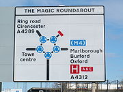
- The Magic RoundaboutMagic Roundabout (Swindon)The Magic Roundabout in Swindon, England was constructed in 1972 and consists of five mini-roundabouts arranged in a circle. It is located near the County Ground, home of Swindon Town F.C. Its name comes from the popular children's television series The Magic Roundabout...
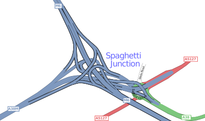
in Swindon, England consists of five mini-roundabouts arranged in a circle. - Gravelly Hill InterchangeGravelly Hill InterchangeGravelly Hill Interchange, better known by its nickname Spaghetti Junction, is junction 6 of the M6 motorway where it meets the A38 Aston Expressway in Birmingham, England.- Overview :...
, one of many known as Spaghetti JunctionSpaghetti Junction"Spaghetti Junction" is a nickname sometimes given to a complicated or massively intertwined road traffic interchange that resembles a plate of spaghetti. The term is believed to have been coined by a journalist at the Birmingham Evening Mail in the 1970s to refer to the Gravelly Hill Interchange...
, is junction 6 of the M6 motorway where it meets the A38(M) Aston Expressway in Birmingham, United Kingdom. - The A64(M) portion of Leeds Inner Ring RoadLeeds Inner Ring RoadThe Leeds Inner Ring Road is part-motorway and part-A roads in Leeds, West Yorkshire, England, which forms a ring road around the city centre. It has six different road numbers that are all sections of longer roads...
is classified as a "pathetic motorway" by one SABRE member because it is "sadly, only 800 yards long and that's if you go the long way." - The expansive but unrealised London RingwaysLondon RingwaysThe London Ringways were a series of four ring roads planned in the 1960s to circle London at various distances from the city centre. They were part of a comprehensive scheme developed by the Greater London Council to alleviate traffic congestion on the city's road system by providing high speed...
system.
United StatesUnited StatesThe United States of America is a federal constitutional republic comprising fifty states and a federal district...
- List of gaps in Interstate Highways
- US Route 66, an iconic highway across the western USA whose remnants attracts enthusiasts from around the globe. There are several Route 66 museums and attractions along the road.
ArkansasArkansasArkansas is a state located in the southern region of the United States. Its name is an Algonquian name of the Quapaw Indians. Arkansas shares borders with six states , and its eastern border is largely defined by the Mississippi River...
- Arkansas Highway 43/Oklahoma State Highway 20 concurrencyConcurrency (road)A concurrency, overlap, or coincidence in a road network is an instance of one physical road bearing two or more different highway, motorway, or other route numbers...
, possibly unique instance of two highways from different states overlapping.
CaliforniaCaliforniaCalifornia is a state located on the West Coast of the United States. It is by far the most populous U.S. state, and the third-largest by land area...

- The Ridge RouteRidge RouteThe Ridge Route, officially the Castaic-Tejon Route, was a two-lane highway running between Los Angeles and Kern counties, California. Opened in 1915 and paved with concrete between 1917 and 1921, the road was the first paved highway directly linking the Los Angeles Basin with the San Joaquin...
, the first paved highway directly linking the Los Angeles BasinLos Angeles BasinThe Los Angeles Basin is the coastal sediment-filled plain located between the Peninsular and Transverse ranges in southern California in the United States containing the central part of the city of Los Angeles as well as its southern and southeastern suburbs...
with the San Joaquin ValleySan Joaquin ValleyThe San Joaquin Valley is the area of the Central Valley of California that lies south of the Sacramento – San Joaquin River Delta in Stockton...
over the Tejon PassTejon PassThe Tejon Pass is a mountain pass at the southwest end of the Tehachapi Mountains linking Southern to Central California.-Geography:The apex of the pass is near the northwesternmost corner of Los Angeles County, north of Gorman...
, a portion of which is in the National Register of Historic PlacesNational Register of Historic PlacesThe National Register of Historic Places is the United States government's official list of districts, sites, buildings, structures, and objects deemed worthy of preservation...
. It was documented by author and roadgeek, Harrison Irving Scott, in 2002. in Ridge Route: The Road That United California. - Skyline Boulevard, the road that spans the highest ridge of Santa Cruz MountainsSanta Cruz MountainsThe Santa Cruz Mountains, part of the Pacific Coast Ranges, are a mountain range in central California, United States. They form a ridge along the San Francisco Peninsula, south of San Francisco, separating the Pacific Ocean from San Francisco Bay and the Santa Clara Valley, and continuing south,...
, making it possible to see the Pacific OceanPacific OceanThe Pacific Ocean is the largest of the Earth's oceanic divisions. It extends from the Arctic in the north to the Southern Ocean in the south, bounded by Asia and Australia in the west, and the Americas in the east.At 165.2 million square kilometres in area, this largest division of the World...
and San Francisco BaySan Francisco BaySan Francisco Bay is a shallow, productive estuary through which water draining from approximately forty percent of California, flowing in the Sacramento and San Joaquin rivers from the Sierra Nevada mountains, enters the Pacific Ocean...
simultaneously. - Decommissioned portions of U.S. Route 6, now part of State Route 14, are the subject of significant roadgeek interest.
- Zzyzx RoadZzyzx, CaliforniaZzyzx, California , formerly Camp Soda and Soda Springs, is a settlement in San Bernardino County, California. It is the former site of the Zzyzx Mineral Springs and Health Spa and now the site of the Desert Studies Center...
, a landmark about halfway between Los AngelesLos ÁngelesLos Ángeles is the capital of the province of Biobío, in the commune of the same name, in Region VIII , in the center-south of Chile. It is located between the Laja and Biobío rivers. The population is 123,445 inhabitants...
and Las VegasLas Vegas, NevadaLas Vegas is the most populous city in the U.S. state of Nevada and is also the county seat of Clark County, Nevada. Las Vegas is an internationally renowned major resort city for gambling, shopping, and fine dining. The city bills itself as The Entertainment Capital of the World, and is famous...
, known for its unusual name. It is the last place on Earth in the English alphabetical order. - Interstate 238Interstate 238Interstate 238 is a short auxiliary route of the Interstate Highway System in the San Francisco Bay Area, California, United States. Part of State Route 238 until 1983, and still considered the same route by the California Department of Transportation , it connects Interstate 580 in Castro Valley...
in the San Francisco Bay AreaSan Francisco Bay AreaThe San Francisco Bay Area, commonly known as the Bay Area, is a populated region that surrounds the San Francisco and San Pablo estuaries in Northern California. The region encompasses metropolitan areas of San Francisco, Oakland, and San Jose, along with smaller urban and rural areas...
which defies numbering logic both by location and the absence of its parent, Interstate 38. - The portion where Interstate 580Interstate 580 (California)Interstate 580 is an 80-mile east–west Interstate Highway in Northern California. The heavily traveled spur route of Interstate 80 runs from San Rafael in the San Francisco Bay Area to Interstate 5 near Tracy in the Central Valley...
and Interstate 80Interstate 80Interstate 80 is the second-longest Interstate Highway in the United States, following Interstate 90. It is a transcontinental artery running from downtown San Francisco, California to Teaneck, New Jersey in the New York City Metropolitan Area...
run concurrently (through Berkeley), which happens to be a wrong-way concurrency. This means that one road goes east and the other goes west at the same time.
ColoradoColoradoColorado is a U.S. state that encompasses much of the Rocky Mountains as well as the northeastern portion of the Colorado Plateau and the western edge of the Great Plains...
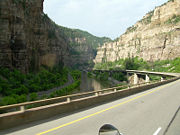
- Interstate 70Interstate 70 in ColoradoInterstate 70 is a transcontinental Interstate Highway in the United States, stretching from Cove Fort, Utah to Baltimore, Maryland. In Colorado, the highway traverses an east–west route across the center of the state. In western Colorado, the highway connects the metropolitan areas of Grand...
's route through Glenwood CanyonGlenwood CanyonGlenwood Canyon is a rugged scenic canyon on the Colorado River in western Colorado in the United States. Its canyon walls climb as high as above the Colorado River. It is the largest such canyon on the Upper Colorado...
, an engineering marvel - Eisenhower TunnelEisenhower TunnelThe Eisenhower Tunnel, officially the Eisenhower–Johnson Memorial Tunnel, is a dual-bore, four-lane vehicular tunnel approximately west of Denver, Colorado, United States. The tunnel carries Interstate 70 under the Continental Divide in the Rocky Mountains. With a maximum elevation of above sea...
, the highest point on the Interstate Highway SystemInterstate Highway SystemThe Dwight D. Eisenhower National System of Interstate and Defense Highways, , is a network of limited-access roads including freeways, highways, and expressways forming part of the National Highway System of the United States of America...
MarylandMarylandMaryland is a U.S. state located in the Mid Atlantic region of the United States, bordering Virginia, West Virginia, and the District of Columbia to its south and west; Pennsylvania to its north; and Delaware to its east...
- I-70's eastern terminusInterstate 70 in MarylandInterstate 70 is a part of the Interstate Highway System that runs from Cove Fort, Utah to Baltimore, Maryland. In Maryland, the Interstate Highway runs from the Pennsylvania state line in Hancock east to the Interstate's eastern terminus near its junction with I-695 at a park and ride in...
at a Park & Ride on Security Boulevard in Baltimore, one of the more unusual Interstate termini
MissouriMissouriMissouri is a US state located in the Midwestern United States, bordered by Iowa, Illinois, Kentucky, Tennessee, Arkansas, Oklahoma, Kansas and Nebraska. With a 2010 population of 5,988,927, Missouri is the 18th most populous state in the nation and the fifth most populous in the Midwest. It...
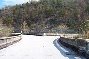
- Galena Y-BridgeY-Bridge (Galena, Missouri)The Y-Bridge is an old highway bridge over the James River located at Galena, Missouri and opened in 1927. It is named the Y-Bridge because it is shaped like the letter "Y". The bridge is such that , one could then either head north or south upon reaching the east end, where the highway was...
, an unusual bridge with three land connections
MontanaMontanaMontana is a state in the Western United States. The western third of Montana contains numerous mountain ranges. Smaller, "island ranges" are found in the central third of the state, for a total of 77 named ranges of the Rocky Mountains. This geographical fact is reflected in the state's name,...
- Going-to-the-Sun RoadGoing-to-the-Sun RoadGoing-to-the-Sun Road is the only road through the heart of Glacier National Park in Montana, USA. It was completed in 1932, and it is the only road that crosses the park, going over the Continental Divide at Logan Pass. A fleet of 1930s red tour buses "jammers", rebuilt in 2001 to run on propane...
, a scenic road crossing Glacier National Park, designated both a National Historic LandmarkNational Historic LandmarkA National Historic Landmark is a building, site, structure, object, or district, that is officially recognized by the United States government for its historical significance...
and a Historic Civil Engineering Landmark.
OklahomaOklahomaOklahoma is a state located in the South Central region of the United States of America. With an estimated 3,751,351 residents as of the 2010 census and a land area of 68,667 square miles , Oklahoma is the 28th most populous and 20th-largest state...
- Arkansas Highway 43/Oklahoma State Highway 20 concurrencyConcurrency (road)A concurrency, overlap, or coincidence in a road network is an instance of one physical road bearing two or more different highway, motorway, or other route numbers...
, possibly unique instance of two highways from different states overlapping.
OregonOregonOregon is a state in the Pacific Northwest region of the United States. It is located on the Pacific coast, with Washington to the north, California to the south, Nevada on the southeast and Idaho to the east. The Columbia and Snake rivers delineate much of Oregon's northern and eastern...
- Historic Columbia River Highway, the first paved highway in the Pacific Northwest, an engineering and scenic marvel, designated both a National Historic LandmarkNational Historic LandmarkA National Historic Landmark is a building, site, structure, object, or district, that is officially recognized by the United States government for its historical significance...
and a Historic Civil Engineering Landmark.
PennsylvaniaPennsylvaniaThe Commonwealth of Pennsylvania is a U.S. state that is located in the Northeastern and Mid-Atlantic regions of the United States. The state borders Delaware and Maryland to the south, West Virginia to the southwest, Ohio to the west, New York and Ontario, Canada, to the north, and New Jersey to...
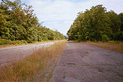
- Abandoned Pennsylvania TurnpikeAbandoned Pennsylvania TurnpikeThe Abandoned Pennsylvania Turnpike is the common name of a 13 mile stretch of the Pennsylvania Turnpike that was bypassed in 1968 when a modern stretch opened to ease traffic congestion in the tunnels. In this case, the Sideling Hill Tunnel and Rays Hill Tunnel were bypassed, as was one of the...
, an example of 1930's-era highway standards - Breezewood, PennsylvaniaBreezewood, PennsylvaniaBreezewood is an unincorporated town in Bedford County in south-central Pennsylvania.Along a traditional pathway for Native Americans, European settlers, and British troops during colonial times, in the early 20th century, the small valley that became known as Breezewood was a popular stopping...
, a gap in Interstate 70Interstate 70Interstate 70 is an Interstate Highway in the United States that runs from Interstate 15 near Cove Fort, Utah, to a Park and Ride near Baltimore, Maryland. It was the first Interstate Highway project in the United States. I-70 approximately traces the path of U.S. Route 40 east of the Rocky...
that routes traffic down US 30 through town - Centralia, PennsylvaniaCentralia, PennsylvaniaCentralia is a borough and ghost town in Columbia County, Pennsylvania, United States. Its population has dwindled from over 1,000 residents in 1981 to 12 in 2005, 9 in 2007, and 10 in 2010, as a result of a mine fire burning beneath the borough since 1962...
, site of underground coal fires undermining the area highways - Interstate 99Interstate 99Interstate 99 is an intrastate Interstate Highway located in central Pennsylvania in the United States. The southern terminus of the route is at exit 146 of the Pennsylvania Turnpike north of Bedford, where the road continues south as U.S. Route 220 . The northern terminus is at...
, which lies west of several lower-numbered interstates, such as Interstate 81Interstate 81Interstate 81 is an Interstate Highway in the eastern part of the United States. Its southern terminus is at Interstate 40 in Dandridge, Tennessee; its northern terminus is on Wellesley Island at the Canadian border, where the Thousand Islands Bridge connects it to Highway 401, the main freeway...
and Interstate 95Interstate 95Interstate 95 is the main highway on the East Coast of the United States, running parallel to the Atlantic Ocean from Maine to Florida and serving some of the most populated urban areas in the country, including Boston, Providence, New Haven, New York City, Newark, Philadelphia, Baltimore,...
VirginiaVirginiaThe Commonwealth of Virginia , is a U.S. state on the Atlantic Coast of the Southern United States. Virginia is nicknamed the "Old Dominion" and sometimes the "Mother of Presidents" after the eight U.S. presidents born there...
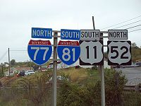
- The wrong-way concurrency of Interstate 81Interstate 81Interstate 81 is an Interstate Highway in the eastern part of the United States. Its southern terminus is at Interstate 40 in Dandridge, Tennessee; its northern terminus is on Wellesley Island at the Canadian border, where the Thousand Islands Bridge connects it to Highway 401, the main freeway...
and Interstate 77Interstate 77Interstate 77 is an Interstate Highway in the eastern United States. It traverses diverse terrain, from the mountainous state of West Virginia to the rolling farmlands of North Carolina and Ohio. It largely supplants the old U.S...
, where one goes north on one route and south on the other at the same time. Located near Wytheville, VA
Washington
- Interstate 82Interstate 82Interstate 82 is a Interstate Highway that extends from I-90 in Ellensburg, Washington to I-84 near Umatilla, Oregon in the United States. In the state of Washington, it serves the cities of Ellensburg, Yakima, and the Tri Cities , and in Oregon, it serves Umatilla and Hermiston...
, which is not only completely north of Interstate 84Interstate 84Interstate 84 may refer to:*Interstate 84 , a freeway extending from Scranton, Pennsylvania to Sturbridge, Massachusetts at the Massachusetts Turnpike *Interstate 84 , a freeway extending from Portland, Oregon to Echo, Utah...
, but also runs predominantly north-south, despite its even number.
Examples
- [news://misc.transport.road misc.transport.road] (UsenetUsenetUsenet is a worldwide distributed Internet discussion system. It developed from the general purpose UUCP architecture of the same name.Duke University graduate students Tom Truscott and Jim Ellis conceived the idea in 1979 and it was established in 1980...
); charter approved November 27, 1995 - misc.transport.road FAQ
- Glasgows Motorways Fan & Info Site
- Roadgeek Yahoo List; founded April 25, 1999
- Society for All British and Irish Road Enthusiasts (SABRE), founded August 13, 1999
- UK sites CBRD, roadsUK and Pathetic Motorways
- Brad's Australian Highways Page; founded September 19, 1999
- Ozroads; founded July 13, 2003
- Great Lakes Roads Yahoo Forum; founded February 16, 2002
- http://www.boards.ie/vbulletin/forumdisplay.php?f=1394Roads forum on boards.ieBoards.ieboards.ie is an Internet forum based in Ireland. It is considered one of the largest indigenous Irish websites online. As of July 2010, the site has 365,000 registered accounts, more than 1,300,000 threads and more than 20 million posts...
] - Northern Ireland Road Site
- Highways and Autobahns on SkyscraperCity
See also
- Spotting: trainspotting, Plane spottingAircraft spottingAircraft spotting or plane spotting is the observation and logging of the registration numbers of aircraft: gliders, powered aircraft, balloons, airships, helicopters, and microlights....
or Bus spottingBus spottingBus spotting is a pastime in which one seeks to see all buses in a particular fleet or those produced by a particular manufacturer. A person who engages in these activities is known as a bus spotter, bus fan , bus nut or bus enthusiast... - Metrophile
- RailfanRailfanA railfan or rail buff , railway enthusiast or railway buff , or trainspotter , is a person interested in a recreational capacity in rail transport...
- Road tripRoad tripA road trip is any journey taken on roads, regardless of stops en route. Typically, road trips are long distances traveled by automobile.-Pre-automobile road trips:...
- Sport touringSport touringA Sport touring motorcycle is a type of motorcycle that blends the performance of a sport bike with the long-distance capabilities of a touring motorcycle, while providing comfort and relative safety to the rider....
- OpenstreetmapOpenStreetMapOpenStreetMap is a collaborative project to create a free editable map of the world. Two major driving forces behind the establishment and growth of OSM have been restrictions on use or availability of map information across much of the world and the advent of inexpensive portable GPS devices.The...