
Santa Cruz Mountains
Encyclopedia
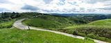
The Santa Cruz Mountains, part of the Pacific Coast Ranges
, are a mountain range
in central California
, United States
. They form a ridge along the San Francisco Peninsula
, south of San Francisco
, separating the Pacific Ocean
from San Francisco Bay
and the Santa Clara Valley
, and continuing south, bordering Monterey Bay
and ending at the Salinas Valley
. The range passes through San Francisco
, San Mateo
, Santa Clara
, Santa Cruz
, San Benito
and Monterey
counties, with San Francisco at the northern end and Salinas
as the southern end.
The northernmost portion of the Santa Cruz Mountains is known as Montara Mountain
, south of Half Moon Bay Road (California State Route 92
) the middle portion is known as the Sierra Morena, which includes a summit called Sierra Morena, and extends south to a gap at Lexington Reservoir
, south of the gap the mountain range is known as the Sierra Azul
.
The highest point in the range is Loma Prieta Peak 3786 feet (1,154 m), near which is the epicenter of the 1989 Loma Prieta earthquake
. Other major peaks include Mount Umunhum
3486 feet (1,062.5 m), Mount Bielawski
3231 feet (984.8 m), El Sombroso 2999 feet (914.1 m), Eagle Rock 2488 feet (758.3 m), Black Mountain
2800 feet (853.4 m), and Sierra Morena 2417 feet (736.7 m). The San Andreas Fault
runs along or near the ridge line throughout the range. The east side of the mountains drops abruptly towards this fault line especially near Woodside
and Saratoga
.
For much of the length of the range on the San Francisco Peninsula, State Route 35
runs along its ridge, and is known as "Skyline Boulevard". The major routes across the mountains are (from north to south) SR 92
from Half Moon Bay
to San Mateo
, SR 84
from San Gregorio
to Redwood City
, SR 9
from Santa Cruz
to Saratoga
, SR 17 from Santa Cruz
to Los Gatos
, SR 152
from Watsonville
to Gilroy
, SR 129
from Watsonville to San Juan Bautista
, and US Highway 101 from Salinas to Gilroy.
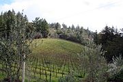
The Santa Cruz Mountains have been a legally defined American Viticultural Area
since 1981. Wine has been produced here since at least the 1840s
. The Santa Cruz Mountain AVA has emerged as premier producer of top wines, recognized in the historic Judgement of Paris on May 26, 1976.
There are over 30 wineries located in this area.
. The Salinian Block
basement rocks are overlain by Miocene
rock strata of the Lompico Sandstone
, the Vaqueros Sandstone
and the Santa Margarita Formation.
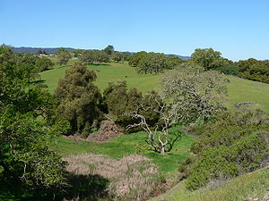
 The Santa Cruz Mountains are a region of large biological diversity, encompassing cool, moist coastal ecosystems as well as warm, dry chaparral
. Much of the area in the Santa Cruz mountains is considered temperate rainforest.
In valleys and moist ocean-facing slopes some of the southernmost coast redwoods grow, along with Coast Douglas-fir, which is at the southern extent of its range. Coast live oak, Pacific madrone, Pacific Wax Myrtle
, Big leaf maple, California bay laurel
, and California Black Oak
also occur in the Santa Cruz Mountains. There do exist several small and isolated stands of old-growth forest, most notably at Henry Cowell Redwoods
and Portola Redwoods State Park
s and one sizeable old-growth redwood forest at Big Basin
. At higher elevations and on sunny south slopes a more drought-resistant chaparral
vegetation dominates: manzanita
, California scrub oak
, chamise
, and chaparral pea
. Spring wildflowers are also widespread throughout the range.
The area welcomes a tremendous number of species of bird
s. (see: bird list). Black-tailed Deer, a subspecies of Mule deer
are common, as are Western Gray Squirrel
s, chipmunk
s and raccoon
s. Fox
es, coyote
s, bobcat
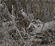
s, cougars and human-introduced Virginia Opossum
s also inhabit the region but are rarely seen. Rattlesnake
s are also inhabitants, mostly in the high, dry chaparral.
, this totals more than 127 centimetres (50 in) annually. Heavy summer fogs frequently cover the western ocean-facing slopes and valleys, resulting in drizzle and fog drip
caused by condensation on the redwoods, pines, and other trees, which sustains the moisture-loving redwood forests. Due to a rain shadow
effect, precipitation on the eastern side of the range is significantly less, about 28 centimetres (11 in) a year. Snow falls a few times a year on the highest ridges, and more rarely the higher valleys receive light dustings.
The National Weather Service
's cooperative weather stations in the mountains have included Black Mountain
2WSW – average annual rainfall 36.65 inches (930.9 mm), maximum annual rainfall 80.66 inches (2,048.8 mm), average annual snowfall 0.7 inches (17.8 mm), maximum annual snowfall 8 inches (203.2 mm); Los Gatos
5SW – average annual rainfall 26.45 inches (671.8 mm), maximum annual rainfall 103.23 inches (2,622 mm), average snowfall 2.7 inches (68.6 mm), maximum annual snowfall 9 inches (228.6 mm); and Wrights
– average annual rainfall 46.09 inches (1,170.7 mm), maximum annual rainfall 87.65 inches (2,226.3 mm), average annual snowfall 1.2 inches (30.5 mm), maximum annual snowfall 10.6 inches (269.2 mm). No temperature records were kept at these stations.
Normal winter temperatures range from the upper 30s °F (~3–4 °C) to the middle 50s °F (~13–14 °C), with valley frosts common but rarely widespread or deep. Summer temperatures regularly reach highs in the 80s °F (~28–29 °C) with nighttime usually in the upper 40s to lower 50s °F (~9–12 °C). Thermal inversions can occur any time of the year where cool air sinks and gets trapped in the valleys.
 The Santa Cruz Mountains are home to an unusual abundance of parks and protected open spaces, notable among them is California's oldest state park: Big Basin Redwoods State Park
. Other state parks include Castle Rock State Park
, Portola Redwoods State Park
, Butano State Park
, The Forest of Nisene Marks State Park
, McNee Ranch State Park
and Henry Cowell Redwoods State Park
with its famous Redwood Grove
walking trail. Additional land is protected by the Midpeninsula Regional Open Space District
, the Peninsula Open Space Trust (POST), the Sempervirens Fund and local county parks districts. Hiking, horse-riding, mountain biking, rock climbing, and backpacking are popular activities. There are two long-distance trails in the range: the Skyline-to-the-Sea Trail
, which winds 38 miles (58 km) from Castle Rock State Park through Big Basin to the Pacific Ocean, and the Bay Area Ridge Trail
, which, while still disjointed, here roughly parallels Skyline Boulevard along the spine of the range. There also exist several backcountry campsites in many of the state parks that enable long distance multi-day outings. Castle Rock State Park has open rock faces suitable for rock climbing and bouldering.
 The previous historic Old Almaden Winery
was located on the eastern slopes of the Santa Cruz Mountains. It was the first commercial winery in California, planting high quality European (French) varietal vines.
Film director Alfred Hitchcock
and his wife Alma had their primary residence near Scotts Valley, the Cornwall Ranch, purchased in September 1940.
In 1965, science fiction author Robert A. Heinlein
constructed a compound in Bonny Doon
, and lived there until shortly before his death in 1988.
Pacific Coast Ranges
The Pacific Coast Ranges and the Pacific Mountain System are the series of mountain ranges that stretch along the West Coast of North America from Alaska south to Northern and Central Mexico...
, are a mountain range
Mountain range
A mountain range is a single, large mass consisting of a succession of mountains or narrowly spaced mountain ridges, with or without peaks, closely related in position, direction, formation, and age; a component part of a mountain system or of a mountain chain...
in central California
California
California is a state located on the West Coast of the United States. It is by far the most populous U.S. state, and the third-largest by land area...
, United States
United States
The United States of America is a federal constitutional republic comprising fifty states and a federal district...
. They form a ridge along the San Francisco Peninsula
San Francisco Peninsula
The San Francisco Peninsula is a peninsula in the San Francisco Bay Area that separates the San Francisco Bay from the Pacific Ocean. On its northern tip is the City and County of San Francisco. Its southern base is in Santa Clara County, including the cities of Palo Alto, Los Altos, and Mountain...
, south of San Francisco
San Francisco, California
San Francisco , officially the City and County of San Francisco, is the financial, cultural, and transportation center of the San Francisco Bay Area, a region of 7.15 million people which includes San Jose and Oakland...
, separating the Pacific Ocean
Pacific Ocean
The Pacific Ocean is the largest of the Earth's oceanic divisions. It extends from the Arctic in the north to the Southern Ocean in the south, bounded by Asia and Australia in the west, and the Americas in the east.At 165.2 million square kilometres in area, this largest division of the World...
from San Francisco Bay
San Francisco Bay
San Francisco Bay is a shallow, productive estuary through which water draining from approximately forty percent of California, flowing in the Sacramento and San Joaquin rivers from the Sierra Nevada mountains, enters the Pacific Ocean...
and the Santa Clara Valley
Santa Clara Valley
The Santa Clara Valley is a valley just south of the San Francisco Bay in Northern California in the United States. Much of Santa Clara County and its county seat, San José, are in the Santa Clara Valley. The valley was originally known as the Valley of Heart’s Delight for its high concentration...
, and continuing south, bordering Monterey Bay
Monterey Bay
Monterey Bay is a bay of the Pacific Ocean, along the central coast of California. The bay is south of San Francisco and San Jose, between the cities of Santa Cruz and Monterey....
and ending at the Salinas Valley
Salinas Valley
The Salinas Valley lies south of San Francisco, California.The word "salina" is spanish for salt marsh, salt lake or salt pan.-Geography:The Salinas Valley runs approximately south-east from Salinas towards King City. The valley lends its name to the geologic province in which it's located, the...
. The range passes through San Francisco
San Francisco, California
San Francisco , officially the City and County of San Francisco, is the financial, cultural, and transportation center of the San Francisco Bay Area, a region of 7.15 million people which includes San Jose and Oakland...
, San Mateo
San Mateo County, California
San Mateo County is a county located in the San Francisco Bay Area of the U.S. state of California. It covers most of the San Francisco Peninsula just south of San Francisco, and north of Santa Clara County. San Francisco International Airport is located at the northern end of the county, and...
, Santa Clara
Santa Clara County, California
Santa Clara County is a county located at the southern end of the San Francisco Bay Area in the U.S. state of California. As of 2010 it had a population of 1,781,642. The county seat is San Jose. The highly urbanized Santa Clara Valley within Santa Clara County is also known as Silicon Valley...
, Santa Cruz
Santa Cruz County, California
Santa Cruz County is a county located on the Pacific coast of the U.S. state of California, on the California Central Coast. The county forms the northern coast of the Monterey Bay. . As of the 2010 U.S. Census, its population was 262,382. The county seat is Santa Cruz...
, San Benito
San Benito County, California
San Benito County is a county located in the Coast Range Mountains of the U.S. state of California, south of San Jose. As of 2010 the population was 55,269. The county seat is Hollister, which includes nearly two-thirds of the county's population. El Camino Real passes through the county and...
and Monterey
Monterey County, California
Monterey County is a county located on the Pacific coast of the U.S. state of California, its northwestern section forming the southern half of Monterey Bay. The northern half of the bay is in Santa Cruz County. As of 2010, the population was 415,057. The county seat and largest city is Salinas...
counties, with San Francisco at the northern end and Salinas
Salinas, California
Salinas is the county seat and the largest municipality of Monterey County, California. Salinas is located east-southeast of the mouth of the Salinas River, at an elevation of about 52 feet above sea level. The population was 150,441 at the 2010 census...
as the southern end.
The northernmost portion of the Santa Cruz Mountains is known as Montara Mountain
Montara Mountain
Montara Mountain, positioned between the unincorporated community of Montara, California to the southwest and the city of Pacifica, California to the north, forms the northern spur of the Santa Cruz Mountains, a narrow mountain range running the length of the San Francisco Peninsula that separates...
, south of Half Moon Bay Road (California State Route 92
California State Route 92
State Route 92 is an east-west highway in the San Francisco Bay area between Half Moon Bay near the coast in the west and downtown Hayward at its junction with State Route 238 and State Route 185. It is most notable for being the route that traverses the San Mateo Bridge. It has interchanges with...
) the middle portion is known as the Sierra Morena, which includes a summit called Sierra Morena, and extends south to a gap at Lexington Reservoir
Lexington Reservoir
Lexington Reservoir is an artificial lake on the Los Gatos Creek near Los Gatos, California. The James J. Lenihan Dam, a high, thick earthen dam, forms the third-largest reservoir in Santa Clara County.-Background:...
, south of the gap the mountain range is known as the Sierra Azul
Sierra Azul
The Sierra Azul is a mountain range in Santa Clara County, California. It is a part of the larger Santa Cruz Mountains. Part of the range is within the Sierra Azul Open Space Preserve....
.
The highest point in the range is Loma Prieta Peak 3786 feet (1,154 m), near which is the epicenter of the 1989 Loma Prieta earthquake
Loma Prieta earthquake
The Loma Prieta earthquake, also known as the Quake of '89 and the World Series Earthquake, was a major earthquake that struck the San Francisco Bay Area of California on October 17, 1989, at 5:04 p.m. local time...
. Other major peaks include Mount Umunhum
Mount Umunhum
Mount Umunhum is the fourth-highest peak in the Santa Cruz Mountains of California . The mountain is situated in Santa Clara County, southeast of Los Gatos and south of South San Jose...
3486 feet (1,062.5 m), Mount Bielawski
Mount Bielawski
Mount Bielawski or Mount Bielewski is located in the Santa Cruz Mountains of California, near the San Francisco Bay Area. The mountain rises to an elevation of just to the southwest of the Santa Cruz – Santa Clara county line and Highway 35.The summit is the highest point in Santa Cruz County...
3231 feet (984.8 m), El Sombroso 2999 feet (914.1 m), Eagle Rock 2488 feet (758.3 m), Black Mountain
Black Mountain (near Los Altos, California)
Black Mountain is a summit on Monte Bello Ridge in the Santa Cruz Mountains of west Santa Clara County, California, south of Los Altos and west of Cupertino. It is located on the border between Rancho San Antonio Open Space Preserve and Monte Bello Open Space Preserve, with the summit located in...
2800 feet (853.4 m), and Sierra Morena 2417 feet (736.7 m). The San Andreas Fault
San Andreas Fault
The San Andreas Fault is a continental strike-slip fault that runs a length of roughly through California in the United States. The fault's motion is right-lateral strike-slip...
runs along or near the ridge line throughout the range. The east side of the mountains drops abruptly towards this fault line especially near Woodside
Woodside, California
Woodside is a small incorporated town in San Mateo County, California, United States, on the San Francisco Peninsula. It uses a council-manager system of government. The U.S. Census estimated the population of the town to be 5,287 in 2010....
and Saratoga
Saratoga, California
Saratoga is a city in Santa Clara County, California, USA. It is located on the west side of the Santa Clara Valley, directly west of San Jose, in the San Francisco Bay area. The population was 29,926 at the 2010 census....
.
For much of the length of the range on the San Francisco Peninsula, State Route 35
California State Route 35
State Route 35 in the U.S. state of California, generally known as Skyline Boulevard, is a two-lane road running along the western ridge of Silicon Valley in California. It runs from Highway 17 to San Francisco at State Route 1. It provides scenic views of both the Santa Cruz Mountains, the...
runs along its ridge, and is known as "Skyline Boulevard". The major routes across the mountains are (from north to south) SR 92
California State Route 92
State Route 92 is an east-west highway in the San Francisco Bay area between Half Moon Bay near the coast in the west and downtown Hayward at its junction with State Route 238 and State Route 185. It is most notable for being the route that traverses the San Mateo Bridge. It has interchanges with...
from Half Moon Bay
Half Moon Bay, California
Half Moon Bay is a coastal city in San Mateo County, California, USA. Its population was 11,324 as of the 2010 census. Immediately at the north of Half Moon Bay is the Pillar Point Harbor and the unincorporated community of Princeton-by-the-Sea....
to San Mateo
San Mateo, California
San Mateo is a city in San Mateo County, California, United States, in the San Francisco Bay Area. With a population of approximately 100,000 , it is one of the larger suburbs on the San Francisco Peninsula, located between Burlingame to the north, Foster City to the east, Belmont to the south,...
, SR 84
California State Route 84
State Route 84 is a split-section California State Highway consisting of two sections. The first section is an east–west arterial road running from San Gregorio to Menlo Park, across the Dumbarton Bridge through Fremont and Newark and ending at I-580 in Livermore. The route overlaps the...
from San Gregorio
San Gregorio, California
-History:Named after Pope Gregory I , San Gregorio was a booming town in the 1850s, when wealthy San Franciscans would travel to the San Gregorio House by stagecoach to enjoy fishing, hunting, sea bathing, and boat races. The building still stands, but is no longer a functioning hotel. However, the...
to Redwood City
Redwood City, California
Redwood City is a California charter city located on the San Francisco Peninsula in Northern California, approximately 27 miles south of San Francisco, and 24 miles north of San Jose. Redwood City's history spans from its earliest inhabitation by the Ohlone people, to its tradition as a port for...
, SR 9
California State Route 9
State Route 9 is mainly a rural and mountainous route in the U.S. state of California that travels 35 miles from SR 1 near Santa Cruz to SR 17 in Los Gatos, passing through the San Lorenzo Valley and the Saratoga Gap...
from Santa Cruz
Santa Cruz, California
Santa Cruz is the county seat and largest city of Santa Cruz County, California in the US. As of the 2010 U.S. Census, Santa Cruz had a total population of 59,946...
to Saratoga
Saratoga, California
Saratoga is a city in Santa Clara County, California, USA. It is located on the west side of the Santa Clara Valley, directly west of San Jose, in the San Francisco Bay area. The population was 29,926 at the 2010 census....
, SR 17 from Santa Cruz
Santa Cruz, California
Santa Cruz is the county seat and largest city of Santa Cruz County, California in the US. As of the 2010 U.S. Census, Santa Cruz had a total population of 59,946...
to Los Gatos
Los Gatos, California
The Town of Los Gatos is an incorporated town in Santa Clara County, California, United States. The population was 29,413 at the 2010 census. It is located in the San Francisco Bay Area at the southwest corner of San Jose in the foothills of the Santa Cruz Mountains...
, SR 152
California State Route 152
State Route 152 is a state highway that runs near the latitudinal middle of the U.S. state of California from Watsonville to Route 99 southeast of Merced...
from Watsonville
Watsonville, California
Watsonville is a city in Santa Cruz County, California, United States. The population was 51,199 according to the 2010 census.Located on the central coast of California, the economy centers predominantly around the farming industry. It is known for growing strawberries, apples, lettuce and a host...
to Gilroy
Gilroy, California
Gilroy is the southernmost city in Santa Clara County, California, United States. The population was 48,821 at the 2010 census. Gilroy is well-known for its garlic crop and for the annual Gilroy Garlic Festival, featuring various garlicky foods, including garlic ice cream. Gilroy also produces...
, SR 129
California State Route 129
State Route 129 is a state highway in the U.S. state of California in Santa Cruz County. The highway connects State Route 1 in Watsonville east to U.S. Route 101.-Route description:...
from Watsonville to San Juan Bautista
San Juan Bautista, California
San Juan Bautista is a city in San Benito County, California, United States. The population was 1,862 at the 2010 census, up from 1,549 at the 2000 census. The city of San Juan Bautista was named after Mission San Juan Bautista...
, and US Highway 101 from Salinas to Gilroy.
The Santa Cruz Mountains have been a legally defined American Viticultural Area
American Viticultural Area
An American Viticultural Area is a designated wine grape-growing region in the United States distinguishable by geographic features, with boundaries defined by the Alcohol and Tobacco Tax and Trade Bureau , United States Department of the Treasury....
since 1981. Wine has been produced here since at least the 1840s
1840s
- Wars :*Mexican-American War was fought between Mexico and the United States of America. The latter emerged victorious and gained undisputed control over Texas while annexing portions of Arizona, California and New Mexico....
. The Santa Cruz Mountain AVA has emerged as premier producer of top wines, recognized in the historic Judgement of Paris on May 26, 1976.
There are over 30 wineries located in this area.
Geology
The Santa Cruz Mountains are largely the result of compressive uplift caused by a leftward bend of the San Andreas FaultSan Andreas Fault
The San Andreas Fault is a continental strike-slip fault that runs a length of roughly through California in the United States. The fault's motion is right-lateral strike-slip...
. The Salinian Block
Salinian Block
The Salinian Block or Salinian terrane is a geologic terrane which lies west of the main trace of the San Andreas Fault system in California. It is bounded on the south by the Big Pine Fault in Ventura County, and on the west by the Nacimiento Fault...
basement rocks are overlain by Miocene
Miocene
The Miocene is a geological epoch of the Neogene Period and extends from about . The Miocene was named by Sir Charles Lyell. Its name comes from the Greek words and and means "less recent" because it has 18% fewer modern sea invertebrates than the Pliocene. The Miocene follows the Oligocene...
rock strata of the Lompico Sandstone
Lompico Sandstone
The Lompico Sandstone is a sedimentary rock formation of lower to middle Miocene age. It overlies the Salinian basement rocks of Santa Cruz County, California. It interfingers with and is overlain by the Miocene Monterey Formation...
, the Vaqueros Sandstone
Vaqueros sandstone
The Vaqueros Formation is a sedimentary geologic unit primarily of Upper Oligocene and Lower Miocene age, which is widespread on the California coast and coastal ranges in approximately the southern half of the state. It is predominantly a medium-grained sandstone unit, deposited in a shallow...
and the Santa Margarita Formation.
Ecology
Chaparral
Chaparral is a shrubland or heathland plant community found primarily in the U.S. state of California and in the northern portion of the Baja California peninsula, Mexico...
. Much of the area in the Santa Cruz mountains is considered temperate rainforest.
In valleys and moist ocean-facing slopes some of the southernmost coast redwoods grow, along with Coast Douglas-fir, which is at the southern extent of its range. Coast live oak, Pacific madrone, Pacific Wax Myrtle
Myrica californica
Myrica californica Myrica californica Myrica californica (California Bayberry, California Wax Myrtle or Pacific Wax Myrtle; syn. Gale californica (Cham. & Schltdl.) Greene, Morella californica (Cham...
, Big leaf maple, California bay laurel
Umbellularia
Umbellularia californica is a large tree native to coastal forests of California and slightly extended into Oregon.It is the sole species in the genus Umbellularia....
, and California Black Oak
California Black Oak
Quercus kelloggii, the California Black Oak, also known as simply Black Oak, or Kellogg Oak, is an oak in the red oak section , native to western North America...
also occur in the Santa Cruz Mountains. There do exist several small and isolated stands of old-growth forest, most notably at Henry Cowell Redwoods
Henry Cowell Redwoods State Park
Henry Cowell Redwoods State Park is a California State Park located in Santa Cruz County, primarily in the area in-between the cities of Santa Cruz, Felton, and Scotts Valley, and the University of California at Santa Cruz, and it includes an extension in the Fall Creek area.-Geography:The main...
and Portola Redwoods State Park
Portola Redwoods State Park
Portola Redwoods State Park is a California state park, located in San Mateo County. Peters Creek and Pescadero Creek meet in Portola, and are the park's primary watercourses, and feature numerous tributaries. Tip Toe Falls is a small waterfall along Fall Creek, a tributary of Pescadero Creek...
s and one sizeable old-growth redwood forest at Big Basin
Big Basin Redwoods State Park
Big Basin Redwoods State Park is a state park in the U.S. state of California, located in Santa Cruz County, about northwest of Santa Cruz. The park contains almost all of the Waddell Creek watershed, which was formed by the seismic uplift of its rim, and the erosion of its center by the many...
. At higher elevations and on sunny south slopes a more drought-resistant chaparral
Chaparral
Chaparral is a shrubland or heathland plant community found primarily in the U.S. state of California and in the northern portion of the Baja California peninsula, Mexico...
vegetation dominates: manzanita
Manzanita
Manzanita is a common name for many species of the genus Arctostaphylos. They are evergreen shrubs or small trees present in the chaparral biome of western North America, where they occur from southern British Columbia, Washington to California, Arizona and New Mexico in the United States, and...
, California scrub oak
California Scrub Oak
Quercus berberidifolia, the California Scrub Oak, is a small evergreen or semi-evergreen shrubby oak in the white oak section Quercus sect. Quercus...
, chamise
Adenostoma fasciculatum
Adenostoma fasciculatum is a flowering plant native to California and northern Baja California. This shrub is one of the most widespread plants of the chaparral biome.-Description:...
, and chaparral pea
Pickeringia montana
Pickeringia is a monotypic genus containing only the legume Pickeringia montana, which is known by the common name chaparral pea. It is sometimes called Montana chaparral pea, but this plant is endemic-found only in California....
. Spring wildflowers are also widespread throughout the range.
The area welcomes a tremendous number of species of bird
Bird
Birds are feathered, winged, bipedal, endothermic , egg-laying, vertebrate animals. Around 10,000 living species and 188 families makes them the most speciose class of tetrapod vertebrates. They inhabit ecosystems across the globe, from the Arctic to the Antarctic. Extant birds range in size from...
s. (see: bird list). Black-tailed Deer, a subspecies of Mule deer
Mule Deer
The mule deer is a deer indigenous to western North America. The Mule Deer gets its name from its large mule-like ears. There are believed to be several subspecies, including the black-tailed deer...
are common, as are Western Gray Squirrel
Western Gray Squirrel
The Western Gray Squirrel is an arboreal rodent found along the western coast of the United States and Canada.In some places, this species has also been known as the Silver-gray Squirrel, the California Gray Squirrel, the Oregon Gray Squirrel, the Columbian Gray Squirrel and the Banner-tail...
s, chipmunk
Chipmunk
Chipmunks are small striped squirrels native to North America and Asia. They are usually classed either as a single genus with three subgenera, or as three genera.-Etymology and taxonomy:...
s and raccoon
Raccoon
Procyon is a genus of nocturnal mammals, comprising three species commonly known as raccoons, in the family Procyonidae. The most familiar species, the common raccoon , is often known simply as "the" raccoon, as the two other raccoon species in the genus are native only to the tropics and are...
s. Fox
Fox
Fox is a common name for many species of omnivorous mammals belonging to the Canidae family. Foxes are small to medium-sized canids , characterized by possessing a long narrow snout, and a bushy tail .Members of about 37 species are referred to as foxes, of which only 12 species actually belong to...
es, coyote
Coyote
The coyote , also known as the American jackal or the prairie wolf, is a species of canine found throughout North and Central America, ranging from Panama in the south, north through Mexico, the United States and Canada...
s, bobcat
Bobcat
The bobcat is a North American mammal of the cat family Felidae, appearing during the Irvingtonian stage of around 1.8 million years ago . With twelve recognized subspecies, it ranges from southern Canada to northern Mexico, including most of the continental United States...
s, cougars and human-introduced Virginia Opossum
Virginia Opossum
The Virginia opossum , commonly known as the North American opossum or tlacuache in Mexico, is the only marsupial found in North America north of Mexico. A solitary and nocturnal animal about the size of a domestic cat, and thus the largest opossum, it is a successful opportunist...
s also inhabit the region but are rarely seen. Rattlesnake
Rattlesnake
Rattlesnakes are a group of venomous snakes of the genera Crotalus and Sistrurus of the subfamily Crotalinae . There are 32 known species of rattlesnake, with between 65-70 subspecies, all native to the Americas, ranging from southern Alberta and southern British Columbia in Canada to Central...
s are also inhabitants, mostly in the high, dry chaparral.
Climate
The Santa Cruz Mountains have a Mediterranean type climate typical of most of California, with the majority of the annual precipitation falling between November and April. According to the National Weather ServiceNational Weather Service
The National Weather Service , once known as the Weather Bureau, is one of the six scientific agencies that make up the National Oceanic and Atmospheric Administration of the United States government...
, this totals more than 127 centimetres (50 in) annually. Heavy summer fogs frequently cover the western ocean-facing slopes and valleys, resulting in drizzle and fog drip
Fog drip
Fog drip is a type of precipitation that forms when fog droplets condense on the needles or leaves of trees or other objects, and drips to the ground....
caused by condensation on the redwoods, pines, and other trees, which sustains the moisture-loving redwood forests. Due to a rain shadow
Rain shadow
A rain shadow is a dry area on the lee side of a mountainous area. The mountains block the passage of rain-producing weather systems, casting a "shadow" of dryness behind them. As shown by the diagram to the right, the warm moist air is "pulled" by the prevailing winds over a mountain...
effect, precipitation on the eastern side of the range is significantly less, about 28 centimetres (11 in) a year. Snow falls a few times a year on the highest ridges, and more rarely the higher valleys receive light dustings.
The National Weather Service
National Weather Service
The National Weather Service , once known as the Weather Bureau, is one of the six scientific agencies that make up the National Oceanic and Atmospheric Administration of the United States government...
's cooperative weather stations in the mountains have included Black Mountain
Black Mountain (near Los Altos, California)
Black Mountain is a summit on Monte Bello Ridge in the Santa Cruz Mountains of west Santa Clara County, California, south of Los Altos and west of Cupertino. It is located on the border between Rancho San Antonio Open Space Preserve and Monte Bello Open Space Preserve, with the summit located in...
2WSW – average annual rainfall 36.65 inches (930.9 mm), maximum annual rainfall 80.66 inches (2,048.8 mm), average annual snowfall 0.7 inches (17.8 mm), maximum annual snowfall 8 inches (203.2 mm); Los Gatos
Los Gatos, California
The Town of Los Gatos is an incorporated town in Santa Clara County, California, United States. The population was 29,413 at the 2010 census. It is located in the San Francisco Bay Area at the southwest corner of San Jose in the foothills of the Santa Cruz Mountains...
5SW – average annual rainfall 26.45 inches (671.8 mm), maximum annual rainfall 103.23 inches (2,622 mm), average snowfall 2.7 inches (68.6 mm), maximum annual snowfall 9 inches (228.6 mm); and Wrights
Wrights, California
Wrights, California is a locale in Santa Clara County, California in the Santa Cruz Mountains, at , near Summit Road, east of State Route 17. It is located on the north bank of Los Gatos Creek....
– average annual rainfall 46.09 inches (1,170.7 mm), maximum annual rainfall 87.65 inches (2,226.3 mm), average annual snowfall 1.2 inches (30.5 mm), maximum annual snowfall 10.6 inches (269.2 mm). No temperature records were kept at these stations.
Normal winter temperatures range from the upper 30s °F (~3–4 °C) to the middle 50s °F (~13–14 °C), with valley frosts common but rarely widespread or deep. Summer temperatures regularly reach highs in the 80s °F (~28–29 °C) with nighttime usually in the upper 40s to lower 50s °F (~9–12 °C). Thermal inversions can occur any time of the year where cool air sinks and gets trapped in the valleys.
Recreation
Big Basin Redwoods State Park
Big Basin Redwoods State Park is a state park in the U.S. state of California, located in Santa Cruz County, about northwest of Santa Cruz. The park contains almost all of the Waddell Creek watershed, which was formed by the seismic uplift of its rim, and the erosion of its center by the many...
. Other state parks include Castle Rock State Park
Castle Rock State Park (California)
Castle Rock State Park is a state park of California, USA, located along the crest of the Santa Cruz Mountains. It embraces coast redwood, Douglas fir, and madrone forest, most of which has been left in its wild, natural state. Steep canyons are sprinkled with unusual rock formations that is a...
, Portola Redwoods State Park
Portola Redwoods State Park
Portola Redwoods State Park is a California state park, located in San Mateo County. Peters Creek and Pescadero Creek meet in Portola, and are the park's primary watercourses, and feature numerous tributaries. Tip Toe Falls is a small waterfall along Fall Creek, a tributary of Pescadero Creek...
, Butano State Park
Butano State Park
Butano State Park is a state park of California, USA, showcasing a secluded redwood-filled canyon. Located in San Mateo County near Pescadero, the park was established in 1956.....
, The Forest of Nisene Marks State Park
The Forest of Nisene Marks State Park
The Forest of Nisene Marks is a State Park located in Aptos, California and contains over of hiking trails and fire roads through approximately of variable terrain. The park was named for Nisene Marks, a passionate nature lover and the mother of a Salinas farming family that purchased the land...
, McNee Ranch State Park
McNee Ranch State Park
McNee Ranch State Park is located in the Santa Cruz Mountains of the United States, near the unincorporated community of Montara, California in San Mateo County. Its highest point rises to 1,898 feet above sea level. An unpaved fire road, the North Peak Access Road, accessible from the Pedro...
and Henry Cowell Redwoods State Park
Henry Cowell Redwoods State Park
Henry Cowell Redwoods State Park is a California State Park located in Santa Cruz County, primarily in the area in-between the cities of Santa Cruz, Felton, and Scotts Valley, and the University of California at Santa Cruz, and it includes an extension in the Fall Creek area.-Geography:The main...
with its famous Redwood Grove
Redwood Grove
The Redwood Grove of Henry Cowell Redwoods State Park, which is located in Santa Cruz County in Northern California, is a grove of Coast Redwoods with member trees extending into the 1400 to 1800-year-old range. This grove is notable because it allows for the use of self-guided tours of the flat, ...
walking trail. Additional land is protected by the Midpeninsula Regional Open Space District
Midpeninsula Regional Open Space District
The Midpeninsula Regional Open Space District is a special-purpose district that manages over of open space in 25 preserves in the San Francisco Bay Area. It includes parts of Santa Clara, San Mateo and Santa Cruz Counties. The District was created by voter initiative in 1972...
, the Peninsula Open Space Trust (POST), the Sempervirens Fund and local county parks districts. Hiking, horse-riding, mountain biking, rock climbing, and backpacking are popular activities. There are two long-distance trails in the range: the Skyline-to-the-Sea Trail
Skyline-to-the-Sea Trail
The Skyline-to-the-Sea Trail is a 29.5-mile hiking trail that descends from the ridge of the Santa Cruz Mountains in Northern California to the Pacific Ocean, passing through Castle Rock State Park and Big Basin Redwoods State Park. Big Basin is California's first state park...
, which winds 38 miles (58 km) from Castle Rock State Park through Big Basin to the Pacific Ocean, and the Bay Area Ridge Trail
Bay Area Ridge Trail
The Bay Area Ridge Trail is a planned 550+-mile multi-use trail along the hill and mountain ridgelines ringing the San Francisco Bay Area, in Northern California. When complete, the trail will connect over 75 parks and open spaces. The trail is being designed to provide access for hikers,...
, which, while still disjointed, here roughly parallels Skyline Boulevard along the spine of the range. There also exist several backcountry campsites in many of the state parks that enable long distance multi-day outings. Castle Rock State Park has open rock faces suitable for rock climbing and bouldering.
Cultural history
Old Almaden Winery
The Old Almaden Winery is an historic wine production site in Santa Clara County, California situated on the eastern slopes of the Santa Cruz Mountains...
was located on the eastern slopes of the Santa Cruz Mountains. It was the first commercial winery in California, planting high quality European (French) varietal vines.
Film director Alfred Hitchcock
Alfred Hitchcock
Sir Alfred Joseph Hitchcock, KBE was a British film director and producer. He pioneered many techniques in the suspense and psychological thriller genres. After a successful career in British cinema in both silent films and early talkies, Hitchcock moved to Hollywood...
and his wife Alma had their primary residence near Scotts Valley, the Cornwall Ranch, purchased in September 1940.
In 1965, science fiction author Robert A. Heinlein
Robert A. Heinlein
Robert Anson Heinlein was an American science fiction writer. Often called the "dean of science fiction writers", he was one of the most influential and controversial authors of the genre. He set a standard for science and engineering plausibility and helped to raise the genre's standards of...
constructed a compound in Bonny Doon
Bonny Doon, California
Bonny Doon is a census-designated place in Santa Cruz County, California. Bonny Doon sits at an elevation of . The 2010 United States census reported Bonny Doon's population was 2,678....
, and lived there until shortly before his death in 1988.
External links
- A resource book for the Santa Cruz Mountains with history and current information about living in the Santa Cruz Mountains.
- www.hiway17.com A community website founded in 1996. Occasionally has a web cam on Highway 17.
- peaklist.org Santa Cruz Mountains ranked by prominence
- summitpost.org Santa Cruz Mountains entry
- Bay Area Hiker South Bay Hikes