
London Ringways
Encyclopedia
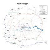
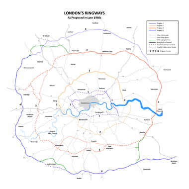
The London Ringways were a series of four ring road
s planned in the 1960s to circle London at various distances from the city centre. They were part of a comprehensive scheme developed by the Greater London Council
to alleviate traffic congestion on the city's road system by providing high speed motorway-standard roads within the capital linking a series of radial roads taking traffic into and out of the city. Following the campaign by Homes before Roads
, the scheme was cancelled in 1973 at which point only three sections had been constructed.
and Sir Edwin Lutyens
published a Ministry of Transport
report, The Highway Development Survey, 1937, which reviewed London's road needs and recommended the construction of many miles of new roads and the improvement of junctions at key congestion points. Amongst their proposals was the provision of a series of orbital roads around the city with the outer ones built as American-style Parkway
s – wide, landscaped roads with limited access and grade separated junctions.
County of London Plan
, 1943 and Greater London Plan, 1944. One of the topics that Abercrombie's two plans had examined was London's traffic congestion, and The County of London Plan proposed a series of ring roads labelled A to E to help remove traffic from the central area.
Even in a war-ravaged city with large areas requiring reconstruction, the building of the two innermost rings, A and B, would have involved considerable demolition and upheaval. The cost of the construction works needed to upgrade the existing London streets and roads to dual carriageway
or motorway standards would have been enormous. Abercrombie's plans were not intended to be carried out immediately but were, instead, an examination of the longer-term options for the future. The post-war austerity period meant that very little of his plan was carried out.
 By the start of the 1960s the number of private cars and commercial vehicles on the roads had increased considerably from the number before the war. The narrow and largely unplanned roads in central London were straining to cope with the traffic load and it was time to address the issue of traffic congestion in the capital.
The Ringway plan took Abercrombie's earlier schemes as a starting point and reused much of his proposals in the outlying areas but scrapped the plans in the inner zone. Abercrombie's A Ring was scrapped as being far too expensive and impractical. The innermost circuit, Ringway 1, was approximately the same distance from the centre as the B Ring, and it used some of Abercrombie's suggested route, but it was planned to use existing transport corridors such as railway lines much more than before. The location of these lines produced a ring that was distinctly box-shaped and Ringway 1 was unofficially called the London Motorway Box.
The 1960s plans were developed over a period of several years and were subject to a continuing process of review and modification. Roads were added and omitted as the overall scheme was altered and many alternative route alignments were considered during the planning process.
The plan was published in stages starting with Ringway 1 in 1966 and Ringway 2 in 1967.
The plan was hugely ambitious and met, almost immediately, with opposition from a number of directions. The report Motorways in London, published in 1969 by the architect/planner Lord Esher and Michael Thomson, a transport economist at the London School of Economics
, calculated that costs had been enormously underestimated and would show marginal economic returns. They predicted large quantities of additional traffic that would be generated purely as a result of the new roads. Access to the new roads would soon be overwhelmed even before the rings and radial roads were near capacity, while about 1 million Londoners would find their lives blighted by living within 200 yards of a motorway. The Treasury
and the Department of Transport
both came out against the scheme, primarily because of worries over the cost.
Despite this opposition the GLC continued to develop its plans and began the construction of some of the earlier parts of the scheme. The plan, still with much of the detail to be worked out, was included in the Greater London Development Plan, 1969 (GLDP) along with much else not related to roads and traffic management. In 1970, the GLC estimated that the cost of building Ringway 1 along with sections of 2 and 3 would be £1.7 billion (approximately £ today). Three-quarters of this would have to come from central government grants.
A public enquiry was held to review the GLDP in a climate of strong and vocal opposition from many of the London Borough
councils and residents associations that would have seen motorways driven through their neighbourhoods. Recognising that the South Cross Route
might prove impossible to build, in 1970 the GLC looked at the possibility of instead integrating public transport through a new park-and-ride scheme at Lewisham
that would serve a new Fleet line
on the London Underground
.
By 1972, in an attempt to placate the Ringway plan's vociferous opponents, the GLC removed the northern section of Ringway 1 and the southern section of Ringway 2 from the proposals and in January 1973, the enquiry recommended that Ringway 1 be built but that much of the rest of the Ringway schemes be abandoned.
The project was submitted to the Conservative government for approval and for a short period it appeared that the GLC may have made enough concessions for the scheme to proceed. After the Labour party made large gains in the GLC elections of April 1973 with a policy of fighting the ringways scheme, and given the continuing fierce opposition across London and the likely enormous cost, the cabinet cancelled funding and hence the project.
and part of the West Cross Route
of Ringway 1
were constructed together with the elevated Westway
which links Paddington
to North Kensington
. These were all begun and completed before the plan was cancelled and, with its elevated roadway on concrete pylons flying above the streets below at roof top height, the Westway provides a good example of how much of Ringway 1 would have appeared had it been constructed.
Improvements have been made to the North Circular Road
(A406) section of Ringway 2
over the decades since the plan was cancelled so that most of it is now dual carriageway. The improvements have been done in a piecemeal fashion so that the road varies in quality and capacity along its length and still has several unimproved single carriageway sections and awkward junctions. By comparison, very little has been done to improve the condition of the South Circular Road
(A205) (which has a number of complex junctions and forks) and no part of the southern part of Ringway 2 has been built, mainly because of the density of the residential areas through which the South Circular runs. The road remains predominantly single carriageway throughout.
Parts of Ringways 3
and 4
were started soon after Ringway 1 was cancelled. The first section of the northern half of Ringway 3 was constructed between South Mimms
and Potters Bar
and opened in 1975. The first section of Ringway 4 was built between Godstone
and Reigate
and opened in 1976. Before the first of these opened, the planned north and east sections of Ringway 3 and the planned south and west sections of Ringway 4 were combined as the M25
(the northern part was initially designated as the M16
during the planning stages but opened as the M25). The remaining sections of these two circular routes were never built.
A number of the radial routes that were planned to connect to the Ringway system were built much as planned: notably the M1
and M4
. Other radial roads, such as the M3 or M23
, were truncated in outer London far from their intended terminal junctions on Ringway 1. Others were simply not built at all in a form recognisable from the Ringway proposal.
Ring road
A ring road, orbital motorway, beltway, circumferential highway, or loop highway is a road that encircles a town or city...
s planned in the 1960s to circle London at various distances from the city centre. They were part of a comprehensive scheme developed by the Greater London Council
Greater London Council
The Greater London Council was the top-tier local government administrative body for Greater London from 1965 to 1986. It replaced the earlier London County Council which had covered a much smaller area...
to alleviate traffic congestion on the city's road system by providing high speed motorway-standard roads within the capital linking a series of radial roads taking traffic into and out of the city. Following the campaign by Homes before Roads
Homes before Roads
Homes before Roads was a 1970s political movement and campaign in the United Kingdom initially formed in London in 1970 to oppose plans to construct a system of four interlinked concentric motorways through and around London, known as Ringways...
, the scheme was cancelled in 1973 at which point only three sections had been constructed.
Ringways
- Ringway 1Ringway 1Ringway 1 or the London Motorway Box was the innermost of the series of four motorway standard roads, known as the London Ringways as part of a comprehensive scheme developed by the Greater London Council to provide high speed motorway-standard roads within the capital linking a series of radial...
- The London Motorway box, comprising the NorthNorth Cross RouteNorth Cross Route was a planned motorway-standard road which would have formed the northern section of Ringway 1 and would have formed the innermost circuit of the London Ringways network. The six-lane dual carriageway with grade separated junctions to an extended M1 Motorway was planned during...
, EastEast Cross RouteEast Cross Route is a dual-carriageway road constructed in east London as part of the uncompleted Ringway 1 as part of the London Ringways plan drawn up the 1960s to create a series of high speed roads circling and radiating out from central London...
, SouthSouth Cross RouteSouth Cross Route was the designation for the southern section of Ringway 1, the innermost circuit of the London Ringways network, a complex and comprehensive plan for a network of high speed roads circling and radiating out from central London designed to manage and control the flow of traffic...
and WestWest Cross RouteThe West Cross Route is a short, dual carriageway section of the A3220 route in central London in The Royal Borough of Kensington and Chelsea, with a small part being shared with borderlining borough Hammersmith and Fulham. It runs north-south between the northern elevated roundabout junction...
Cross Routes. - Ringway 2Ringway 2Ringway 2 was the second innermost of the series of four London Ringways, ring roads planned in the 1960s to circle London at various distances from the city centre...
- Upgrade of North Circular RoadA406 roadThe A406 or the North Circular Road is a road which crosses North London, UK, linking West and East London. It, together with the South Circular Road, forms a ring road through the inner part of Outer London...
and replacement for South Circular RoadA205 roadThe A205 or South Circular Road is a direct route which crosses South London, UK, running from Woolwich in the east to the junction of the A406 , the M4 and the A4 at Gunnersbury in the west....
. - Ringway 3Ringway 3Ringway 3 was the third from the centre of the series of four London Ringways, ring roads planned in the 1960s to circle London at various distances from the city centre...
- A new road, the north section of which became part of the M25M25 motorwayThe M25 motorway, or London Orbital, is a orbital motorway that almost encircles Greater London, England, in the United Kingdom. The motorway was first mooted early in the 20th century. A few sections, based on the now abandoned London Ringways plan, were constructed in the early 1970s and it ...
. - Ringway 4Ringway 4Ringway 4 was the outermost of the series of four London Ringways, ring roads planned in the 1960s to circle London at various distances from the city centre...
- A new road, the south section of which became part of the M25 and M26M26 motorwayThe M26 is a motorway in Kent, England. It provides a short link between the M25/A21 at Sevenoaks and the M20 near Wrotham.-Route:The motorway starts at junction 3 of the M20 and heads west, encountering almost immediately the single junction along its length where it has an interchange with the A20...
.
The Highway Development Survey, 1937
In May 1938, Sir Charles BresseyCharles Bressey
Sir Charles Herbert Bressey CB, CBE was a civil engineer and surveyor who specialised in road design. Bressey was Chief Engineer for Roads at the Ministry of Transport from 1921 to 1938...
and Sir Edwin Lutyens
Edwin Lutyens
Sir Edwin Landseer Lutyens, OM, KCIE, PRA, FRIBA was a British architect who is known for imaginatively adapting traditional architectural styles to the requirements of his era...
published a Ministry of Transport
Department for Transport
In the United Kingdom, the Department for Transport is the government department responsible for the English transport network and a limited number of transport matters in Scotland, Wales and Northern Ireland which are not devolved...
report, The Highway Development Survey, 1937, which reviewed London's road needs and recommended the construction of many miles of new roads and the improvement of junctions at key congestion points. Amongst their proposals was the provision of a series of orbital roads around the city with the outer ones built as American-style Parkway
Parkway
The term parkway has several distinct principal meanings and numerous synonyms around the world, for either a type of landscaped area or a type of road.Type of landscaped area:...
s – wide, landscaped roads with limited access and grade separated junctions.
County of London Plan, 1940s
The Ringway plan had developed from early schemes prior to the Second World War through Sir Patrick Abercrombie'sPatrick Abercrombie
Sir Leslie Patrick Abercrombie ) was an English town planner. Educated at Uppingham School, Rutland; brother of Lascelles Abercrombie, poet and literary critic.-Career:...
County of London Plan
County of London Plan
The County of London Plan was prepared for the London County Council in 1943. Its authors were John Henry Forshaw and Sir Leslie Patrick Abercrombie ....
, 1943 and Greater London Plan, 1944. One of the topics that Abercrombie's two plans had examined was London's traffic congestion, and The County of London Plan proposed a series of ring roads labelled A to E to help remove traffic from the central area.
Even in a war-ravaged city with large areas requiring reconstruction, the building of the two innermost rings, A and B, would have involved considerable demolition and upheaval. The cost of the construction works needed to upgrade the existing London streets and roads to dual carriageway
Dual carriageway
A dual carriageway is a class of highway with two carriageways for traffic travelling in opposite directions separated by a central reservation...
or motorway standards would have been enormous. Abercrombie's plans were not intended to be carried out immediately but were, instead, an examination of the longer-term options for the future. The post-war austerity period meant that very little of his plan was carried out.
Ringway Scheme, 1960s
The Ringway plan took Abercrombie's earlier schemes as a starting point and reused much of his proposals in the outlying areas but scrapped the plans in the inner zone. Abercrombie's A Ring was scrapped as being far too expensive and impractical. The innermost circuit, Ringway 1, was approximately the same distance from the centre as the B Ring, and it used some of Abercrombie's suggested route, but it was planned to use existing transport corridors such as railway lines much more than before. The location of these lines produced a ring that was distinctly box-shaped and Ringway 1 was unofficially called the London Motorway Box.
The 1960s plans were developed over a period of several years and were subject to a continuing process of review and modification. Roads were added and omitted as the overall scheme was altered and many alternative route alignments were considered during the planning process.
The plan was published in stages starting with Ringway 1 in 1966 and Ringway 2 in 1967.
The plan was hugely ambitious and met, almost immediately, with opposition from a number of directions. The report Motorways in London, published in 1969 by the architect/planner Lord Esher and Michael Thomson, a transport economist at the London School of Economics
London School of Economics
The London School of Economics and Political Science is a public research university specialised in the social sciences located in London, United Kingdom, and a constituent college of the federal University of London...
, calculated that costs had been enormously underestimated and would show marginal economic returns. They predicted large quantities of additional traffic that would be generated purely as a result of the new roads. Access to the new roads would soon be overwhelmed even before the rings and radial roads were near capacity, while about 1 million Londoners would find their lives blighted by living within 200 yards of a motorway. The Treasury
HM Treasury
HM Treasury, in full Her Majesty's Treasury, informally The Treasury, is the United Kingdom government department responsible for developing and executing the British government's public finance policy and economic policy...
and the Department of Transport
Department for Transport
In the United Kingdom, the Department for Transport is the government department responsible for the English transport network and a limited number of transport matters in Scotland, Wales and Northern Ireland which are not devolved...
both came out against the scheme, primarily because of worries over the cost.
Despite this opposition the GLC continued to develop its plans and began the construction of some of the earlier parts of the scheme. The plan, still with much of the detail to be worked out, was included in the Greater London Development Plan, 1969 (GLDP) along with much else not related to roads and traffic management. In 1970, the GLC estimated that the cost of building Ringway 1 along with sections of 2 and 3 would be £1.7 billion (approximately £ today). Three-quarters of this would have to come from central government grants.
A public enquiry was held to review the GLDP in a climate of strong and vocal opposition from many of the London Borough
London borough
The administrative area of Greater London contains thirty-two London boroughs. Inner London comprises twelve of these boroughs plus the City of London. Outer London comprises the twenty remaining boroughs of Greater London.-Functions:...
councils and residents associations that would have seen motorways driven through their neighbourhoods. Recognising that the South Cross Route
South Cross Route
South Cross Route was the designation for the southern section of Ringway 1, the innermost circuit of the London Ringways network, a complex and comprehensive plan for a network of high speed roads circling and radiating out from central London designed to manage and control the flow of traffic...
might prove impossible to build, in 1970 the GLC looked at the possibility of instead integrating public transport through a new park-and-ride scheme at Lewisham
Lewisham
Lewisham is a district in South London, England, located in the London Borough of Lewisham. It is situated south-east of Charing Cross. The area is identified in the London Plan as one of 35 major centres in Greater London.-History:...
that would serve a new Fleet line
Jubilee Line
The Jubilee line is a line on the London Underground , in the United Kingdom. It was built in two major sections—initially to Charing Cross, in central London, and later extended, in 1999, to Stratford, in east London. The later stations are larger and have special safety features, both aspects...
on the London Underground
London Underground
The London Underground is a rapid transit system serving a large part of Greater London and some parts of Buckinghamshire, Hertfordshire and Essex in England...
.
By 1972, in an attempt to placate the Ringway plan's vociferous opponents, the GLC removed the northern section of Ringway 1 and the southern section of Ringway 2 from the proposals and in January 1973, the enquiry recommended that Ringway 1 be built but that much of the rest of the Ringway schemes be abandoned.
The project was submitted to the Conservative government for approval and for a short period it appeared that the GLC may have made enough concessions for the scheme to proceed. After the Labour party made large gains in the GLC elections of April 1973 with a policy of fighting the ringways scheme, and given the continuing fierce opposition across London and the likely enormous cost, the cabinet cancelled funding and hence the project.
Legacy
In the central London area only the East Cross RouteEast Cross Route
East Cross Route is a dual-carriageway road constructed in east London as part of the uncompleted Ringway 1 as part of the London Ringways plan drawn up the 1960s to create a series of high speed roads circling and radiating out from central London...
and part of the West Cross Route
West Cross Route
The West Cross Route is a short, dual carriageway section of the A3220 route in central London in The Royal Borough of Kensington and Chelsea, with a small part being shared with borderlining borough Hammersmith and Fulham. It runs north-south between the northern elevated roundabout junction...
of Ringway 1
Ringway 1
Ringway 1 or the London Motorway Box was the innermost of the series of four motorway standard roads, known as the London Ringways as part of a comprehensive scheme developed by the Greater London Council to provide high speed motorway-standard roads within the capital linking a series of radial...
were constructed together with the elevated Westway
Westway (London)
The Westway is a long elevated dual carriageway section of the A40 route in west London running from Paddington to North Kensington. The road was constructed between 1964 and 1970 to relieve congestion at Shepherd's Bush caused by traffic from Western Avenue struggling to enter central London on...
which links Paddington
Paddington
Paddington is a district within the City of Westminster, in central London, England. Formerly a metropolitan borough, it was integrated with Westminster and Greater London in 1965...
to North Kensington
Kensington
Kensington is a district of west and central London, England within the Royal Borough of Kensington and Chelsea. An affluent and densely-populated area, its commercial heart is Kensington High Street, and it contains the well-known museum district of South Kensington.To the north, Kensington is...
. These were all begun and completed before the plan was cancelled and, with its elevated roadway on concrete pylons flying above the streets below at roof top height, the Westway provides a good example of how much of Ringway 1 would have appeared had it been constructed.
Improvements have been made to the North Circular Road
A406 road
The A406 or the North Circular Road is a road which crosses North London, UK, linking West and East London. It, together with the South Circular Road, forms a ring road through the inner part of Outer London...
(A406) section of Ringway 2
Ringway 2
Ringway 2 was the second innermost of the series of four London Ringways, ring roads planned in the 1960s to circle London at various distances from the city centre...
over the decades since the plan was cancelled so that most of it is now dual carriageway. The improvements have been done in a piecemeal fashion so that the road varies in quality and capacity along its length and still has several unimproved single carriageway sections and awkward junctions. By comparison, very little has been done to improve the condition of the South Circular Road
A205 road
The A205 or South Circular Road is a direct route which crosses South London, UK, running from Woolwich in the east to the junction of the A406 , the M4 and the A4 at Gunnersbury in the west....
(A205) (which has a number of complex junctions and forks) and no part of the southern part of Ringway 2 has been built, mainly because of the density of the residential areas through which the South Circular runs. The road remains predominantly single carriageway throughout.
Parts of Ringways 3
Ringway 3
Ringway 3 was the third from the centre of the series of four London Ringways, ring roads planned in the 1960s to circle London at various distances from the city centre...
and 4
Ringway 4
Ringway 4 was the outermost of the series of four London Ringways, ring roads planned in the 1960s to circle London at various distances from the city centre...
were started soon after Ringway 1 was cancelled. The first section of the northern half of Ringway 3 was constructed between South Mimms
South Mimms
South Mimms, sometimes spelt South Mymms, is a village and civil parish forming part of the Hertsmere district of Hertfordshire County Council in the East of England although geographically and historically is in the County of Middlesex.-History:...
and Potters Bar
Potters Bar
Potters Bar is a town in the Hertsmere borough of Hertfordshire, England, located north of Central London. In 2001 it had a population of 21,618....
and opened in 1975. The first section of Ringway 4 was built between Godstone
Godstone
Godstone is a village in the county of Surrey, England. It is located approximately six miles east of Reigate at the junction of the A22 and A25 major roads, and near the M25 motorway.-History:...
and Reigate
Reigate
Reigate is a historic market town in Surrey, England, at the foot of the North Downs, and in the London commuter belt. It is one of the main constituents of the Borough of Reigate and Banstead...
and opened in 1976. Before the first of these opened, the planned north and east sections of Ringway 3 and the planned south and west sections of Ringway 4 were combined as the M25
M25 motorway
The M25 motorway, or London Orbital, is a orbital motorway that almost encircles Greater London, England, in the United Kingdom. The motorway was first mooted early in the 20th century. A few sections, based on the now abandoned London Ringways plan, were constructed in the early 1970s and it ...
(the northern part was initially designated as the M16
M16 motorway
The M16 motorway was the designation planned in the late 1960s and early 1970s for use on Ringway 3, a new motorway planned as part of the London Ringways Plan to run a circular route around London....
during the planning stages but opened as the M25). The remaining sections of these two circular routes were never built.
A number of the radial routes that were planned to connect to the Ringway system were built much as planned: notably the M1
M1 motorway
The M1 is a north–south motorway in England primarily connecting London to Leeds, where it joins the A1 near Aberford. While the M1 is considered to be the first inter-urban motorway to be completed in the United Kingdom, the first road to be built to motorway standard in the country was the...
and M4
M4 motorway
The M4 motorway links London with South Wales. It is part of the unsigned European route E30. Other major places directly accessible from M4 junctions are Reading, Swindon, Bristol, Newport, Cardiff and Swansea...
. Other radial roads, such as the M3 or M23
M23 motorway
The M23 motorway is a motorway in England. The motorway runs from south of Hooley in Surrey, where it splits from the A23, to Pease Pottage, south of Crawley in West Sussex where it rejoins the A23. The northern end of the motorway starts at junction 7 on what is effectively a spur north from...
, were truncated in outer London far from their intended terminal junctions on Ringway 1. Others were simply not built at all in a form recognisable from the Ringway proposal.
Motorways
- M11 motorwayM11 motorwayThe M11 motorway in England is a major road running approximately north from the North Circular Road in South Woodford in north-east London to the A14, north-west of Cambridge.-Route:...
– was planned to connect to the Ringways plan; eventually in the 1990s the M11 link road (part of the A12) controversially connected to the North Circular Road (see M11 link road protestM11 link road protestThe M11 link road protest was a major anti-road protest in east London, United Kingdom, in the early 1990s opposing the construction of the "A12 Hackney to M11 link road", also known as the M11 Link Road...
) - M12 motorwayM12 motorwayThe M12 motorway was a planned motorway starting in north-east London and joining the A12 road in Essex. The 1960s scheme would have started at a junction with the M11 motorway and North Circular and ended near Brentwood, Chelmsford or at the proposed new Maplin Sands airport; the motorway was part...
– unbuilt motorway connecting M11 and Ringways 2 and 3 with BrentwoodBrentwood, EssexBrentwood is a town and the principal settlement of the Borough of Brentwood, in the county of Essex in the east of England. It is located in the London commuter belt, 20 miles east north-east of Charing Cross in London, and near the M25 motorway....
or ChelmsfordChelmsfordChelmsford is the county town of Essex, England and the principal settlement of the borough of Chelmsford. It is located in the London commuter belt, approximately northeast of Charing Cross, London, and approximately the same distance from the once provincial Roman capital at Colchester... - M15 motorway – unused motorway designation for Ringway 2
- M16 motorwayM16 motorwayThe M16 motorway was the designation planned in the late 1960s and early 1970s for use on Ringway 3, a new motorway planned as part of the London Ringways Plan to run a circular route around London....
– unused motorway designation for Ringway 3 - M23 motorwayM23 motorwayThe M23 motorway is a motorway in England. The motorway runs from south of Hooley in Surrey, where it splits from the A23, to Pease Pottage, south of Crawley in West Sussex where it rejoins the A23. The northern end of the motorway starts at junction 7 on what is effectively a spur north from...
– was once intended to extend northwards to Ringway 2
London orbital railways
- OrbirailOrbirailOrbirail was a name for a suggested orbital railway route around London. It would involve connecting the extended North London Line, East London Line, the Inner South London Line and the West London Line, possibly including the Gospel Oak to Barking Line. The combined line would orbit London in...
– unimplemented - London OvergroundLondon OvergroundLondon Overground is a suburban rail network in London and Hertfordshire. It has been operated by London Overground Rail Operations since 2007 as part of the National Rail network, under the franchise control and branding of Transport for London...
– similar plan, under construction
External links
- cbrd.co.uk - History of the Ringways
- Pathetic Motorways - Ringways for beginners
- Unfinished London - Episode 2 - video by Jay ForemanJay Foreman (comedian)Jay Foreman is a British musical comedian based in London. His brother is Beardyman, the UK beatboxing champion. They have collaborated on stage several times....