
Interstate 99
Encyclopedia
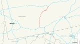
Interstate 99 is an intrastate Interstate Highway located in central Pennsylvania
in the United States. The southern terminus of the route is at exit 146 of the Pennsylvania Turnpike
(I-70
and I-76
) north of Bedford
, where the road continues south as U.S. Route 220 (US 220). The northern terminus is at I-80 near Bellefonte
. I-99 passes through Altoona
and State College
–the latter home to Pennsylvania State University
–and is entirely concurrent
to US 220. Long-term plans call for I-99 to be extended southward along the US 220 corridor to an interchange with I-68
in Cumberland, Maryland
, and northward along the US 220 and US 15
corridors to an interchange with I-86
west of Corning, New York
.
Unlike most Interstate Highway numbers, which were assigned by the American Association of State Highway and Transportation Officials
(AASHTO) to fit into a grid, I-99's number was written into Section 332 of the National Highway Designation Act of 1995 by Bud Shuster
, then-chair of the U.S. House Committee on Transportation and Infrastructure, the bill's sponsor, and the representative of the district through which the highway runs. I-99 violates the AASHTO numbering convention associated with Interstate Highways, since it lies east of I-79
but west of I-81
.
(designated as I-70 and I-76
) north of Bedford
. It begins concurrent with US 220, which continues south from the interchange toward the Maryland
state line as a two-lane highway known as the Appalachian Thruway. The interchange with the Turnpike requires drivers to use a short segment of US 220 Business to access the Turnpike at exit 146. North of the Turnpike junction, the limited-access highway becomes the Bud Shuster Highway as it heads through a rural portion of Bedford County
. It connects to Pennsylvania Route 56 (PA 56) just west of the Bedford County Airport
at exit 3 and PA 869
at exit 7 before crossing into Blair County
. Here, it meets PA 164
north of East Freedom at exit 23 prior to entering the Altoona
area.
In Hollidaysburg
, a borough south of the city, I-99 and US 220 connect to US 22 at exit 28, a large modified trumpet interchange. This junction allows travelers to head west towards Ebensburg
, Johnstown
, and Pittsburgh
. The freeway continues to Altoona itself, where it indirectly connects to PA 36
via exit 32. Unlike the original routing of US 220 which goes through the city center, I-99 and US 220 mostly bypass it to the east, connecting to the city via streets leading eastward from the downtown district. At the northern edge of Altoona, PA 764
joins the old alignment of US 220 and parallels I-99 north for 3 miles (5 km) toward Bellwood
. PA 764 leaves old US 220 about 2 miles (3.2 km) south of Bellwood, however, and terminates at I-99 exit 39. Bellwood itself is served by exit 41, which leads to PA 865
.
The highway veers northeastward from Bellwood to serve the borough of Tyrone
, located at the junction of old US 220 and PA 453
. Access to the borough is made by way of exit 48, which serves PA 453. Past Tyrone, I-99 and US 220 head through sparsely populated areas of Blair and Centre
Counties. For this reason, only three exits exist between Tyrone and State College
: exit 52, serving PA 350
and the small community of Bald Eagle
, and exits 61 and 62, which connect to US 322 and the borough of Port Matilda
. Here, US 322 joins I-99 and US 220 and follows them eastward to the State College area.
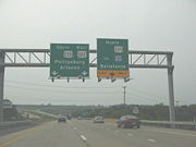
At exit 68 (US 322 Business
), I-99 merges into the Mount Nittany Expressway, an older, northerly bypass of State College. I-99, US 220, and US 322 follow the expressway to the Mount Nittany Interchange, a directional T interchange located on the northern fringe of the Pennsylvania State University
campus. US 322 continues east through the interchange to follow the Mount Nittany Expressway while I-99 and US 220 split from US 322 and head northeastward toward Pleasant Gap
, which I-99 connects to via exit 81 and PA 26
. At this point, PA 26 joins the freeway and follows it to Bellefonte
, served by exit 83 and PA 550
. I-99 ends about 2.5 miles (4 km) later at an interchange with I-80, where PA 26 continues north and US 220 joins I-80 east.
 Corridor O of the Appalachian Development Highway System
was assigned in 1925, running from Cumberland, Maryland
(Corridor E, now I-68
) to Bellefonte (I-80) along US 220
. The portion in Pennsylvania
, from Bedford
north to Bald Eagle
, was upgraded to a freeway in stages from the 1960s to the 1990s. The first section, from US 30 in Bedford to PA 56
near Cessna, opened in the latter half of the 1960s. Two more sections—from PA 56 north to modern exit 15 in Blair County
and from Charlottsville (exit 45) to Bald Eagle—were completed in the 1970s. The portion between exit 15 and Altoona
(exit 33) was finished in the 1980s while the segment between modern exits 33 and 45 was opened by 1997.
In 1991, the Intermodal Surface Transportation Efficiency Act
(ISTEA) was signed into law. It included a number of High Priority Corridors, one of which—Corridor 9—ran along US 220 from Bedford to Williamsport
, and then north on US 15
to Corning, New York
. The National Highway Designation Act of 1995 amended ISTEA; among these amendments were that "the portion of the route referred to in subsection (c)(9) [Corridor 9] is designated as Interstate Route I-99." This was the first Interstate Highway number to be written into law rather than to be assigned by AASHTO
. The number was specificated by Representative Bud Shuster
, who said that the standard spur numbering was not "catchy"; instead, I-99 was named after a street car, No. 99, that took people from Shuster's hometown of Glassport
to McKeesport
. I-99 violates the AASHTO numbering convention associated with Interstate Highways, since it lies east of I-79
but west of I-81
.
in Bedford to PA 350
in Bald Eagle. In 2002, plans were set in motion to extend I-99 northeast from Bald Eagle to State College
via Port Matilda
. The extension was fraught with issues, however. The proposed alignment for the highway north to Port Matilda proved to be controversial: while environmentalists called for I-99 to be constructed in the valley below Bald Eagle Ridge, the Pennsylvania Department of Transportation
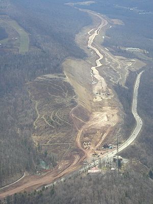
(PennDOT) and valley residents favored a routing that took the freeway above the valley and along the side of the ridge. Farther north, the widening of Skytop, the mountain cut that US 322 uses to traverse Bald Eagle Ridge, resulted in the exposure of acidic pyrite
rock in 2003.
 Work on the segment ceased one year later as PennDOT attempted to stop the flow of acidic runoff from the site. The state remedied the situation by removing 1000000 cubic yards (764,554.9 m³) of pyrite and replacing it with a mix of limestone
and fill, a process that took two years and cost $83 million. With the environmental issues settled, construction resumed on the portion of the freeway south of Skytop Mountain. The section from Bald Eagle to Port Matilda was opened to traffic on December 17, 2007, while the remaining section between Port Matilda and the west end of the Mount Nittany Expressway near State College was completely opened on November 17, 2008. In all, the Bald Eagle – State College section of I-99 cost $631 million to construct.
I-99 was extended northeastward to meet I-80 northeast of Bellefonte
following the completion of the Bald Eagle – State College segment. The connection was made by way of the pre-existing Mount Nittany Expressway and another, unnamed limited-access highway connecting the State College bypass to the Bellefonte area. The portion of the latter highway north of the PA 26
interchange was originally built in the 1970s as a two-lane freeway
connecting Pleasant Gap
to I-80. At the time, it was designated solely as PA 26. It was widened to four lanes in 1997. The piece connecting the PA 26 freeway to the Mount Nittany Expressway was completed in 2002. US 220 was rerouted via US 322 and the new road, and the old alignment of US 220 north of US 322 was designated US 220 Alternate on May 30, 2003.
to Williamsport
and northward along US 15
from Williamsport to I-86
in Corning, New York
. Signs have been placed along the present US 220 and US 15 between Bellefonte and Corning—much of which are built to Interstate Highway standards
—marking the route as the "Future I-99 Corridor". The entirety of US 15 north of Williamsport is a limited-access highway save for a 4.5 miles (7.2 km) segment in New York
between Lindley
and Presho. Construction on the missing piece is underway and is expected to be completed in 2012.
Pennsylvania
The Commonwealth of Pennsylvania is a U.S. state that is located in the Northeastern and Mid-Atlantic regions of the United States. The state borders Delaware and Maryland to the south, West Virginia to the southwest, Ohio to the west, New York and Ontario, Canada, to the north, and New Jersey to...
in the United States. The southern terminus of the route is at exit 146 of the Pennsylvania Turnpike
Pennsylvania Turnpike
The Pennsylvania Turnpike is a toll highway system operated by the Pennsylvania Turnpike Commission in the Commonwealth of Pennsylvania, United States. The three sections of the turnpike system total . The main section extends from Ohio to New Jersey and is long...
(I-70
Interstate 70
Interstate 70 is an Interstate Highway in the United States that runs from Interstate 15 near Cove Fort, Utah, to a Park and Ride near Baltimore, Maryland. It was the first Interstate Highway project in the United States. I-70 approximately traces the path of U.S. Route 40 east of the Rocky...
and I-76
Interstate 76 (east)
Interstate 76 is an Interstate Highway in the United States, running 435 miles from an interchange with Interstate 71 west of Akron, Ohio, east to Interstate 295 near Camden, New Jersey....
) north of Bedford
Bedford, Pennsylvania
Bedford is a borough in Bedford County, Pennsylvania, west of the State Capital, Harrisburg. It is the county seat of Bedford County. Bedford was established in the mid-18th century. Population counts follow: 1890, 2,242; 1900, 2,167; 1910, 2,385. The population was 3,141 at the 2000...
, where the road continues south as U.S. Route 220 (US 220). The northern terminus is at I-80 near Bellefonte
Bellefonte, Pennsylvania
Bellefonte is a borough in Centre County, Pennsylvania, United States. It lies about twelve miles northeast of State College and is part of the State College, Pennsylvania Metropolitan Statistical Area...
. I-99 passes through Altoona
Altoona, Pennsylvania
-History:A major railroad town, Altoona was founded by the Pennsylvania Railroad in 1849 as the site for a shop complex. Altoona was incorporated as a borough on February 6, 1854, and as a city under legislation approved on April 3, 1867, and February 8, 1868...
and State College
State College, Pennsylvania
State College is the largest borough in Centre County in the U.S. state of Pennsylvania. It is the principal city of the State College, Pennsylvania Metropolitan Statistical Area which encompasses all of Centre County. As of the 2010 census, the borough population was 42,034, and roughly double...
–the latter home to Pennsylvania State University
Pennsylvania State University
The Pennsylvania State University, commonly referred to as Penn State or PSU, is a public research university with campuses and facilities throughout the state of Pennsylvania, United States. Founded in 1855, the university has a threefold mission of teaching, research, and public service...
–and is entirely concurrent
Concurrency (road)
A concurrency, overlap, or coincidence in a road network is an instance of one physical road bearing two or more different highway, motorway, or other route numbers...
to US 220. Long-term plans call for I-99 to be extended southward along the US 220 corridor to an interchange with I-68
Interstate 68
Interstate 68 is a Interstate highway in the U.S. states of West Virginia and Maryland, connecting in Morgantown to in Hancock. is also Corridor E of the Appalachian Development Highway System. From 1965 until the freeway's construction was completed in 1991, it was designated as...
in Cumberland, Maryland
Cumberland, Maryland
Cumberland is a city in the far western, Appalachian portion of Maryland, United States. It is the county seat of Allegany County, and the primary city of the Cumberland, MD-WV Metropolitan Statistical Area. At the 2010 census, the city had a population of 20,859, and the metropolitan area had a...
, and northward along the US 220 and US 15
U.S. Route 15
U.S. Route 15 is a -long United States highway, designated along South Carolina, North Carolina, Virginia, Maryland, Pennsylvania, and New York. The route is signed north–south, from U.S. Route 17 Alternate in Walterboro, South Carolina to Interstate 86 and NY 17 in Painted Post, New York.US...
corridors to an interchange with I-86
Interstate 86 (east)
Interstate 86 is an Interstate Highway that extends for through northwestern Pennsylvania and southern New York in the United States...
west of Corning, New York
Corning (city), New York
Corning is a city in Steuben County, New York, United States, on the Chemung River. The population was 10,842 at the 2000 census. It is named for Erastus Corning, an Albany financier and railroad executive who was an investor in the company that developed the community.- Overview :The city of...
.
Unlike most Interstate Highway numbers, which were assigned by the American Association of State Highway and Transportation Officials
American Association of State Highway and Transportation Officials
AASHTO, the American Association of State Highway and Transportation Officials, is a standards setting body which publishes specifications, test protocols and guidelines which are used in highway design and construction throughout the United States...
(AASHTO) to fit into a grid, I-99's number was written into Section 332 of the National Highway Designation Act of 1995 by Bud Shuster
Bud Shuster
Elmer Greinert "Bud" Shuster is an American politician who represented Pennsylvania in the United States House of Representatives as a Republican from 1973 to 2001. He is best known for his advocacy of transportation projects that critics deride as "pork barrel" spending.-Career:Shuster was born...
, then-chair of the U.S. House Committee on Transportation and Infrastructure, the bill's sponsor, and the representative of the district through which the highway runs. I-99 violates the AASHTO numbering convention associated with Interstate Highways, since it lies east of I-79
Interstate 79
Interstate 79 is an Interstate Highway in the eastern United States, designated from Interstate 77 in Charleston, West Virginia to Pennsylvania Route 5 and Pennsylvania Route 290 in Erie, Pennsylvania...
but west of I-81
Interstate 81
Interstate 81 is an Interstate Highway in the eastern part of the United States. Its southern terminus is at Interstate 40 in Dandridge, Tennessee; its northern terminus is on Wellesley Island at the Canadian border, where the Thousand Islands Bridge connects it to Highway 401, the main freeway...
.
Route description
I-99 begins at an indirect interchange with US 220 and the Pennsylvania TurnpikePennsylvania Turnpike
The Pennsylvania Turnpike is a toll highway system operated by the Pennsylvania Turnpike Commission in the Commonwealth of Pennsylvania, United States. The three sections of the turnpike system total . The main section extends from Ohio to New Jersey and is long...
(designated as I-70 and I-76
Interstate 76 (east)
Interstate 76 is an Interstate Highway in the United States, running 435 miles from an interchange with Interstate 71 west of Akron, Ohio, east to Interstate 295 near Camden, New Jersey....
) north of Bedford
Bedford, Pennsylvania
Bedford is a borough in Bedford County, Pennsylvania, west of the State Capital, Harrisburg. It is the county seat of Bedford County. Bedford was established in the mid-18th century. Population counts follow: 1890, 2,242; 1900, 2,167; 1910, 2,385. The population was 3,141 at the 2000...
. It begins concurrent with US 220, which continues south from the interchange toward the Maryland
Maryland
Maryland is a U.S. state located in the Mid Atlantic region of the United States, bordering Virginia, West Virginia, and the District of Columbia to its south and west; Pennsylvania to its north; and Delaware to its east...
state line as a two-lane highway known as the Appalachian Thruway. The interchange with the Turnpike requires drivers to use a short segment of US 220 Business to access the Turnpike at exit 146. North of the Turnpike junction, the limited-access highway becomes the Bud Shuster Highway as it heads through a rural portion of Bedford County
Bedford County, Pennsylvania
Bedford County is a county located in the U.S. state of Pennsylvania. As of the 2010 census, the population was 49,762. The county seat is Bedford. It is part of the Altoona, Pennsylvania, Metropolitan Statistical Area.- History :...
. It connects to Pennsylvania Route 56 (PA 56) just west of the Bedford County Airport
Bedford County Airport
Bedford County Airport is a public use airport in Bedford County, Pennsylvania, United States. It is owned by the Bedford County Airport Authority and is located four nautical miles north of the central business district of the borough of Bedford, Pennsylvania. It opened in 1994.Although most U.S...
at exit 3 and PA 869
Pennsylvania Route 869
Pennsylvania Route 869 is an east–west state route located in Western Pennsylvania. Its western terminus is at Ragers Hill Road just west of US 219 in St...
at exit 7 before crossing into Blair County
Blair County, Pennsylvania
-Significant Topographic Features:*Brush Mountain*Logan Valley*Morrison Cove*Tussey Mountain-Demographics:As of the census of 2000, there were 129,144 people, 51,518 households, and 34,877 families residing in the county. The population density was 246 people per square mile . There were 55,061...
. Here, it meets PA 164
Pennsylvania Route 164
Pennsylvania Route 164 is an long state highway located in Cambria, Blair, Bedford counties in Pennsylvania. The western terminus is at an interchange with US 22 in Munster Township...
north of East Freedom at exit 23 prior to entering the Altoona
Altoona, Pennsylvania
-History:A major railroad town, Altoona was founded by the Pennsylvania Railroad in 1849 as the site for a shop complex. Altoona was incorporated as a borough on February 6, 1854, and as a city under legislation approved on April 3, 1867, and February 8, 1868...
area.
In Hollidaysburg
Hollidaysburg, Pennsylvania
Hollidaysburg is a borough in Blair County, Pennsylvania, on the Juniata River, south of Altoona. It is the county seat of Blair County. It is part of the Altoona, Pennsylvania, Metropolitan Statistical Area and is one of the communities that comprises the Altoona Urban Area...
, a borough south of the city, I-99 and US 220 connect to US 22 at exit 28, a large modified trumpet interchange. This junction allows travelers to head west towards Ebensburg
Ebensburg, Pennsylvania
Ebensburg is a borough located in, and is the seat of, Cambria County, Pennsylvania, west of Altoona and surrounded by Cambria Township. It is situated in the Alleghenies about 2025 feet above sea level. Ebensburg is located in a rich bituminous coal region. In the past, saw mills, tanneries,...
, Johnstown
Johnstown, Pennsylvania
Johnstown is a city in Cambria County, Pennsylvania, United States, west-southwest of Altoona, Pennsylvania and east of Pittsburgh. The population was 20,978 at the 2010 census. It is the principal city of the Johnstown, Pennsylvania, Metropolitan Statistical Area, which includes Cambria County...
, and Pittsburgh
Pittsburgh, Pennsylvania
Pittsburgh is the second-largest city in the US Commonwealth of Pennsylvania and the county seat of Allegheny County. Regionally, it anchors the largest urban area of Appalachia and the Ohio River Valley, and nationally, it is the 22nd-largest urban area in the United States...
. The freeway continues to Altoona itself, where it indirectly connects to PA 36
Pennsylvania Route 36
Pennsylvania Route 36 is a long state highway located in the U.S. state of Pennsylvania. The southern terminus is at Pennsylvania Route 26 near the Hopewell Township community of Yellow Creek...
via exit 32. Unlike the original routing of US 220 which goes through the city center, I-99 and US 220 mostly bypass it to the east, connecting to the city via streets leading eastward from the downtown district. At the northern edge of Altoona, PA 764
Pennsylvania Route 764
Pennsylvania Route 764 is a north–south state highway in Blair County, of the U.S. state of Pennsylvania. The route is one of many major north–south throughfares in Altoona. South of the city near Duncansville, a suburb and unofficial section of Altoona, it terminates at an interchange...
joins the old alignment of US 220 and parallels I-99 north for 3 miles (5 km) toward Bellwood
Bellwood, Pennsylvania
Bellwood is a borough in Blair County, Pennsylvania, United States. It is part of the Altoona, PA Metropolitan Statistical Area. The population was 2,016 at the 2000 census.-Geography:Bellwood is located at ....
. PA 764 leaves old US 220 about 2 miles (3.2 km) south of Bellwood, however, and terminates at I-99 exit 39. Bellwood itself is served by exit 41, which leads to PA 865
Pennsylvania Route 865
Pennsylvania Route 865 is an long state highway located in Blair, Cambria, and Clearfield counties in Pennsylvania. The southern terminus is at I 99/US 220 in Bellwood. The northern terminus is at PA 53 in Coalport.-Blair County:...
.
The highway veers northeastward from Bellwood to serve the borough of Tyrone
Tyrone, Pennsylvania
Tyrone is a borough in Blair County, Pennsylvania, northeast of Altoona, on the Little Juniata River. Tyrone was of considerable commercial importance in the twentieth century. It was an outlet for the Clearfield coal fields, and it was noted for the manufacture of paper products. There were...
, located at the junction of old US 220 and PA 453
Pennsylvania Route 453
Pennsylvania Route 453 is a long state highway located in Huntingdon, Blair, and Clearfield counties in Pennsylvania. The southern terminus is at US 22 in Water Street; the northern terminus is at PA 879 in Curwensville....
. Access to the borough is made by way of exit 48, which serves PA 453. Past Tyrone, I-99 and US 220 head through sparsely populated areas of Blair and Centre
Centre County, Pennsylvania
Centre County is a county located in the U.S. state of Pennsylvania. It is part of the State College, Pennsylvania Metropolitan Statistical Area. As of 2010, the population was 153,990....
Counties. For this reason, only three exits exist between Tyrone and State College
State College, Pennsylvania
State College is the largest borough in Centre County in the U.S. state of Pennsylvania. It is the principal city of the State College, Pennsylvania Metropolitan Statistical Area which encompasses all of Centre County. As of the 2010 census, the borough population was 42,034, and roughly double...
: exit 52, serving PA 350
Pennsylvania Route 350
Pennsylvania Route 350 is an long state highway located in Huntingdon, Blair, and Centre counties in Pennsylvania. The southern terminus is at PA 45 in Franklin Township...
and the small community of Bald Eagle
Bald Eagle, Blair County, Pennsylvania
Bald Eagle is an unincorporated populated place in Blair County, Pennsylvania, United States. It is located in the Bald Eagle Valley at the foot of the Bald Eagle Mountain ridge, along the Fill Run near its confluence with the headwaters of the Bald Eagle Creek tributary of the Little Juniata River...
, and exits 61 and 62, which connect to US 322 and the borough of Port Matilda
Port Matilda, Pennsylvania
Port Matilda is a borough in Centre County, Pennsylvania, United States. It is part of the State College, Pennsylvania Metropolitan Statistical Area...
. Here, US 322 joins I-99 and US 220 and follows them eastward to the State College area.
At exit 68 (US 322 Business
U.S. Route 322 Business (State College, Pennsylvania)
U.S. Route 322 Business is a business loop of U.S. 322 in Centre County, Pennsylvania. Its western terminus is at an interchange with I-99, U.S. 322, and U.S. 220 near State College; its eastern terminus is at U.S. 322 near Boalsburg....
), I-99 merges into the Mount Nittany Expressway, an older, northerly bypass of State College. I-99, US 220, and US 322 follow the expressway to the Mount Nittany Interchange, a directional T interchange located on the northern fringe of the Pennsylvania State University
Pennsylvania State University
The Pennsylvania State University, commonly referred to as Penn State or PSU, is a public research university with campuses and facilities throughout the state of Pennsylvania, United States. Founded in 1855, the university has a threefold mission of teaching, research, and public service...
campus. US 322 continues east through the interchange to follow the Mount Nittany Expressway while I-99 and US 220 split from US 322 and head northeastward toward Pleasant Gap
Pleasant Gap, Pennsylvania
Pleasant Gap is a census-designated place in Centre County, Pennsylvania, United States. It is part of the State College, Pennsylvania Metropolitan Statistical Area...
, which I-99 connects to via exit 81 and PA 26
Pennsylvania Route 26
Pennsylvania Route 26 is a highway in the south-central area of Pennsylvania. Its northern terminus is at Pennsylvania Route 150 northwest of Howard, Pennsylvania; its southern terminus is at the Maryland state line near Barnes Gap in Union Township...
. At this point, PA 26 joins the freeway and follows it to Bellefonte
Bellefonte, Pennsylvania
Bellefonte is a borough in Centre County, Pennsylvania, United States. It lies about twelve miles northeast of State College and is part of the State College, Pennsylvania Metropolitan Statistical Area...
, served by exit 83 and PA 550
Pennsylvania Route 550
Pennsylvania Route 550 is a 36 mile long state highway in Pennsylvania. The southern terminus of the route is at Pennsylvania Route 45 Truck and Pennsylvania Route 453 east of Tyrone...
. I-99 ends about 2.5 miles (4 km) later at an interchange with I-80, where PA 26 continues north and US 220 joins I-80 east.
Origins
Appalachian Development Highway System
The Appalachian Development Highway System is part of the Appalachian Regional Commission in the United States. See: .-History:...
was assigned in 1925, running from Cumberland, Maryland
Cumberland, Maryland
Cumberland is a city in the far western, Appalachian portion of Maryland, United States. It is the county seat of Allegany County, and the primary city of the Cumberland, MD-WV Metropolitan Statistical Area. At the 2010 census, the city had a population of 20,859, and the metropolitan area had a...
(Corridor E, now I-68
Interstate 68
Interstate 68 is a Interstate highway in the U.S. states of West Virginia and Maryland, connecting in Morgantown to in Hancock. is also Corridor E of the Appalachian Development Highway System. From 1965 until the freeway's construction was completed in 1991, it was designated as...
) to Bellefonte (I-80) along US 220
U.S. Route 220
U.S. Route 220 is a long U.S. Route in the eastern United States.US 220 is a spur route of U.S. Route 20 but at present, the two routes do not intersect nor do they connect via other spurs of US 20. The former U. S. Route 120, which was signed in Pennsylvania between 1926 and 1967, intersected...
. The portion in Pennsylvania
Pennsylvania
The Commonwealth of Pennsylvania is a U.S. state that is located in the Northeastern and Mid-Atlantic regions of the United States. The state borders Delaware and Maryland to the south, West Virginia to the southwest, Ohio to the west, New York and Ontario, Canada, to the north, and New Jersey to...
, from Bedford
Bedford, Pennsylvania
Bedford is a borough in Bedford County, Pennsylvania, west of the State Capital, Harrisburg. It is the county seat of Bedford County. Bedford was established in the mid-18th century. Population counts follow: 1890, 2,242; 1900, 2,167; 1910, 2,385. The population was 3,141 at the 2000...
north to Bald Eagle
Bald Eagle, Blair County, Pennsylvania
Bald Eagle is an unincorporated populated place in Blair County, Pennsylvania, United States. It is located in the Bald Eagle Valley at the foot of the Bald Eagle Mountain ridge, along the Fill Run near its confluence with the headwaters of the Bald Eagle Creek tributary of the Little Juniata River...
, was upgraded to a freeway in stages from the 1960s to the 1990s. The first section, from US 30 in Bedford to PA 56
Pennsylvania Route 56
Pennsylvania Route 56 is a major long state highway located in central Pennsylvania. Its western terminus is at the eastern approach to the C.L. Schmitt Bridge in New Kensington. Its eastern terminus is U.S. Route 30 west of Bedford.- Route description :...
near Cessna, opened in the latter half of the 1960s. Two more sections—from PA 56 north to modern exit 15 in Blair County
Blair County, Pennsylvania
-Significant Topographic Features:*Brush Mountain*Logan Valley*Morrison Cove*Tussey Mountain-Demographics:As of the census of 2000, there were 129,144 people, 51,518 households, and 34,877 families residing in the county. The population density was 246 people per square mile . There were 55,061...
and from Charlottsville (exit 45) to Bald Eagle—were completed in the 1970s. The portion between exit 15 and Altoona
Altoona, Pennsylvania
-History:A major railroad town, Altoona was founded by the Pennsylvania Railroad in 1849 as the site for a shop complex. Altoona was incorporated as a borough on February 6, 1854, and as a city under legislation approved on April 3, 1867, and February 8, 1868...
(exit 33) was finished in the 1980s while the segment between modern exits 33 and 45 was opened by 1997.
In 1991, the Intermodal Surface Transportation Efficiency Act
Intermodal Surface Transportation Efficiency Act
The Intermodal Surface Transportation Efficiency Act of 1991 is a United States federal law that posed a major change to transportation planning and policy, as the first U.S. federal legislation on the subject in the post-Interstate Highway System era...
(ISTEA) was signed into law. It included a number of High Priority Corridors, one of which—Corridor 9—ran along US 220 from Bedford to Williamsport
Williamsport, Pennsylvania
Williamsport is a city in and the county seat of Lycoming County, Pennsylvania in the United States. In 2009, the population was estimated at 29,304...
, and then north on US 15
U.S. Route 15
U.S. Route 15 is a -long United States highway, designated along South Carolina, North Carolina, Virginia, Maryland, Pennsylvania, and New York. The route is signed north–south, from U.S. Route 17 Alternate in Walterboro, South Carolina to Interstate 86 and NY 17 in Painted Post, New York.US...
to Corning, New York
Corning (city), New York
Corning is a city in Steuben County, New York, United States, on the Chemung River. The population was 10,842 at the 2000 census. It is named for Erastus Corning, an Albany financier and railroad executive who was an investor in the company that developed the community.- Overview :The city of...
. The National Highway Designation Act of 1995 amended ISTEA; among these amendments were that "the portion of the route referred to in subsection (c)(9) [Corridor 9] is designated as Interstate Route I-99." This was the first Interstate Highway number to be written into law rather than to be assigned by AASHTO
American Association of State Highway and Transportation Officials
AASHTO, the American Association of State Highway and Transportation Officials, is a standards setting body which publishes specifications, test protocols and guidelines which are used in highway design and construction throughout the United States...
. The number was specificated by Representative Bud Shuster
Bud Shuster
Elmer Greinert "Bud" Shuster is an American politician who represented Pennsylvania in the United States House of Representatives as a Republican from 1973 to 2001. He is best known for his advocacy of transportation projects that critics deride as "pork barrel" spending.-Career:Shuster was born...
, who said that the standard spur numbering was not "catchy"; instead, I-99 was named after a street car, No. 99, that took people from Shuster's hometown of Glassport
Glassport, Pennsylvania
Glassport is a borough in Allegheny County, Pennsylvania, United States, approximately south of Pittsburgh and the confluence of the Monongahela and Allegheny rivers where they form the Ohio River...
to McKeesport
McKeesport, Pennsylvania
McKeesport is a city in Allegheny County, Pennsylvania, in the United States; it is located at the confluence of the Monongahela and Youghiogheny rivers and is part of the Pittsburgh Metro Area. The population was 19,731 at the 2010 census...
. I-99 violates the AASHTO numbering convention associated with Interstate Highways, since it lies east of I-79
Interstate 79
Interstate 79 is an Interstate Highway in the eastern United States, designated from Interstate 77 in Charleston, West Virginia to Pennsylvania Route 5 and Pennsylvania Route 290 in Erie, Pennsylvania...
but west of I-81
Interstate 81
Interstate 81 is an Interstate Highway in the eastern part of the United States. Its southern terminus is at Interstate 40 in Dandridge, Tennessee; its northern terminus is on Wellesley Island at the Canadian border, where the Thousand Islands Bridge connects it to Highway 401, the main freeway...
.
Designation and Bald Eagle Ridge
On November 6, 1998, AASHTO formally approved the I-99 designation, which initially extended 51.2 miles (82.4 km) from the Pennsylvania TurnpikePennsylvania Turnpike
The Pennsylvania Turnpike is a toll highway system operated by the Pennsylvania Turnpike Commission in the Commonwealth of Pennsylvania, United States. The three sections of the turnpike system total . The main section extends from Ohio to New Jersey and is long...
in Bedford to PA 350
Pennsylvania Route 350
Pennsylvania Route 350 is an long state highway located in Huntingdon, Blair, and Centre counties in Pennsylvania. The southern terminus is at PA 45 in Franklin Township...
in Bald Eagle. In 2002, plans were set in motion to extend I-99 northeast from Bald Eagle to State College
State College, Pennsylvania
State College is the largest borough in Centre County in the U.S. state of Pennsylvania. It is the principal city of the State College, Pennsylvania Metropolitan Statistical Area which encompasses all of Centre County. As of the 2010 census, the borough population was 42,034, and roughly double...
via Port Matilda
Port Matilda, Pennsylvania
Port Matilda is a borough in Centre County, Pennsylvania, United States. It is part of the State College, Pennsylvania Metropolitan Statistical Area...
. The extension was fraught with issues, however. The proposed alignment for the highway north to Port Matilda proved to be controversial: while environmentalists called for I-99 to be constructed in the valley below Bald Eagle Ridge, the Pennsylvania Department of Transportation
Pennsylvania Department of Transportation
The Pennsylvania Department of Transportation oversees transportation issues in the Commonwealth of Pennsylvania. The administrator of PennDOT is the Pennsylvania Secretary of Transportation, currently Barry Schoch Presently, PennDOT supports over of state roads and highways, about 25,000...
(PennDOT) and valley residents favored a routing that took the freeway above the valley and along the side of the ridge. Farther north, the widening of Skytop, the mountain cut that US 322 uses to traverse Bald Eagle Ridge, resulted in the exposure of acidic pyrite
Pyrite
The mineral pyrite, or iron pyrite, is an iron sulfide with the formula FeS2. This mineral's metallic luster and pale-to-normal, brass-yellow hue have earned it the nickname fool's gold because of its resemblance to gold...
rock in 2003.
Limestone
Limestone is a sedimentary rock composed largely of the minerals calcite and aragonite, which are different crystal forms of calcium carbonate . Many limestones are composed from skeletal fragments of marine organisms such as coral or foraminifera....
and fill, a process that took two years and cost $83 million. With the environmental issues settled, construction resumed on the portion of the freeway south of Skytop Mountain. The section from Bald Eagle to Port Matilda was opened to traffic on December 17, 2007, while the remaining section between Port Matilda and the west end of the Mount Nittany Expressway near State College was completely opened on November 17, 2008. In all, the Bald Eagle – State College section of I-99 cost $631 million to construct.
I-99 was extended northeastward to meet I-80 northeast of Bellefonte
Bellefonte, Pennsylvania
Bellefonte is a borough in Centre County, Pennsylvania, United States. It lies about twelve miles northeast of State College and is part of the State College, Pennsylvania Metropolitan Statistical Area...
following the completion of the Bald Eagle – State College segment. The connection was made by way of the pre-existing Mount Nittany Expressway and another, unnamed limited-access highway connecting the State College bypass to the Bellefonte area. The portion of the latter highway north of the PA 26
Pennsylvania Route 26
Pennsylvania Route 26 is a highway in the south-central area of Pennsylvania. Its northern terminus is at Pennsylvania Route 150 northwest of Howard, Pennsylvania; its southern terminus is at the Maryland state line near Barnes Gap in Union Township...
interchange was originally built in the 1970s as a two-lane freeway
Two-lane freeway
A two-lane expressway is an expressway with only one lane in each direction, and usually no median barrier. It may be built that way because of constraints, or may be intended for expansion once traffic volumes rise. The term super two is often used by roadgeeks for this type of road, but traffic...
connecting Pleasant Gap
Pleasant Gap, Pennsylvania
Pleasant Gap is a census-designated place in Centre County, Pennsylvania, United States. It is part of the State College, Pennsylvania Metropolitan Statistical Area...
to I-80. At the time, it was designated solely as PA 26. It was widened to four lanes in 1997. The piece connecting the PA 26 freeway to the Mount Nittany Expressway was completed in 2002. US 220 was rerouted via US 322 and the new road, and the old alignment of US 220 north of US 322 was designated US 220 Alternate on May 30, 2003.
Future
Long-term plans for I-99 call for the freeway to be extended northeastward along US 220 from BellefonteBellefonte, Pennsylvania
Bellefonte is a borough in Centre County, Pennsylvania, United States. It lies about twelve miles northeast of State College and is part of the State College, Pennsylvania Metropolitan Statistical Area...
to Williamsport
Williamsport, Pennsylvania
Williamsport is a city in and the county seat of Lycoming County, Pennsylvania in the United States. In 2009, the population was estimated at 29,304...
and northward along US 15
U.S. Route 15
U.S. Route 15 is a -long United States highway, designated along South Carolina, North Carolina, Virginia, Maryland, Pennsylvania, and New York. The route is signed north–south, from U.S. Route 17 Alternate in Walterboro, South Carolina to Interstate 86 and NY 17 in Painted Post, New York.US...
from Williamsport to I-86
Interstate 86 (east)
Interstate 86 is an Interstate Highway that extends for through northwestern Pennsylvania and southern New York in the United States...
in Corning, New York
Corning (city), New York
Corning is a city in Steuben County, New York, United States, on the Chemung River. The population was 10,842 at the 2000 census. It is named for Erastus Corning, an Albany financier and railroad executive who was an investor in the company that developed the community.- Overview :The city of...
. Signs have been placed along the present US 220 and US 15 between Bellefonte and Corning—much of which are built to Interstate Highway standards
Interstate Highway standards
Standards for Interstate Highways in the United States are defined by the American Association of State Highway and Transportation Officials in the publication A Policy on Design Standards - Interstate System...
—marking the route as the "Future I-99 Corridor". The entirety of US 15 north of Williamsport is a limited-access highway save for a 4.5 miles (7.2 km) segment in New York
New York
New York is a state in the Northeastern region of the United States. It is the nation's third most populous state. New York is bordered by New Jersey and Pennsylvania to the south, and by Connecticut, Massachusetts and Vermont to the east...
between Lindley
Lindley, New York
Lindley is a town in southern Steuben County, New York, United States. The population was 1,913 at the 2000 census. The town was named after the early settler Eleazer Lindsley.The town is situated south of the city of Corning.-Geography:...
and Presho. Construction on the missing piece is underway and is expected to be completed in 2012.