
Abandoned Pennsylvania Turnpike
Encyclopedia
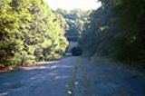
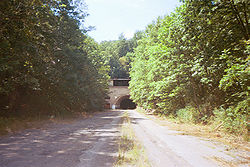
The Abandoned Pennsylvania Turnpike is the common name of a 13 mile (21 km) stretch of the Pennsylvania Turnpike
that was bypassed in 1968 when a modern stretch opened to ease traffic congestion in the tunnel
s. In this case, the Sideling Hill Tunnel
and Rays Hill Tunnel
were bypassed, as was one of the Turnpike's travel plazas. The bypass is located just east of the heavily congested Breezewood
interchange for I-70 eastbound at what is now I-76 exit 161.
 When the Turnpike opened in 1940, it was known as the "Tunnel Highway" because it contained seven tunnels from east to west: Blue Mountain
, Kittatinny Mountain
, Tuscarora Mountain
, Sideling Hill
, Rays Hill
, Allegheny Mountain
, and Laurel Hill
. There was one tunnel through each mountain, and the highway was reduced to a single lane in each direction through each tunnel.
Originally, this was not a problem, but by the late 1950s, the Turnpike was so heavily used that traffic congestion demanded expansion. The Pennsylvania Turnpike Commission
(PTC) conducted studies on either expanding or bypassing the tunnels. The result was the "twinning" of four tunnels (by constructing a second, parallel, two-lane tunnel), and outright bypass and closure of the other three. The tunnels through the Blue
, Kittatinny
, Tuscarora
, and Allegheny
mountains were expanded through the "twinning" process, while the other three were bypassed. The Laurel Hill Tunnel, located on the border of Westmoreland County
and Somerset County
, was one of these tunnels, though the bypass was only around two miles (3 km) long.
The Sideling Hill and Rays Hill tunnels, on the other hand, were near each other, and a 13 miles (20.9 km) bypass was required. As a result, the Cove Valley Travel Plaza, which was located between the eastern portal of the Sideling Hill Tunnel and the main Turnpike, was bypassed. It was replaced with a new Sideling Hill Travel Plaza, which, unlike the plaza it replaced, was a single building serving travelers from both directions of the highway.
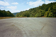
 Today, the Abandoned Turnpike, as it is commonly known, has become a popular tourist attraction. The PTC sold most of the property to the Southern Alleghenies Conservancy
(SAC) for $1 in 2001. The property is managed by Friends of the Pike 2 Bike, a coalition of non-profit groups (including the SAC) to eventually convert the stretch into a bike trail. The property is officially closed to the public (see below), and no motor vehicles are allowed on the property, but riders are free to use it at their own risk. The trail requires helmets and lights. Because this stretch sits on parts of the former right-of-way of the South Pennsylvania Railroad
that was never completed but later formed the basis of the mainline Turnpike, this makes the Pike2Bike unofficially a rail trail
. The PTC still owns a stretch of about one quarter mile on the west and 3.5 miles (5.6 km) on the east for maintenance purposes.
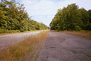
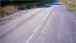
The entranceways to the tunnels were in respectable shape through the early 1980s, when vandalism and time began to take their toll; thieves stole even the lettering of the signs of the tunnels, sometime between 1981 and 1999. The tunnels themselves are still standing and, despite not having been maintained for decades, are still structurally sound.
A business plan/feasibility study was completed by Gannett Flemming in 2005. It proposed various ideas to make the trail as accessible as possible for cyclists, hikers, roller bladers, and equestrians.
, the trail is in the process of changing ownership to Bedford County
. This is in response to the Department of Conservation and Natural Resources' need for a governmental body to own the trail before it can give out grants. The Friends of the Pike 2 Bike will continue to run and oversee the trail.
was used as the test vehicle.
 The PTC and PennDOT used the highway to train maintenance workers, as well as for testing of rumble strip
s.
There have also been numerous military uses for the highway; the tunnels were considered as a storage area for weapons, as was the open highway for aircraft. The military also used the highway for training soldiers for Iraq in the early 2000s, even after the highway was sold to the SAC.
The site of the former Cove Valley Travel Plaza was used as a shooting range for the Pennsylvania State Police
. Since the SAC bought the property, the site has not been used as a shooting range, although warning signs are still posted in the area.
In 2008 the highway was used for the filming of the Dimension Films
movie The Road starring Viggo Mortensen
. The studios mildly restored the exterior of the eastern portal of the Sideling Hill Tunnel when it was used for filming.
 The Abandoned Turnpike is perhaps the best-known of tunnel bypasses on toll roads. Among the other bypassed tunnels:
 In late 2005, the PTC restricted access to the Abandoned Turnpike by demolishing an overpass over US 30
in Breezewood as well as an overpass on Pump Station Road near the site of the old Cove Valley Travel Plaza. The removal of the overpasses, while preventing motorized vehicles from easily entering the Abandoned Turnpike, was done to remove the liability and expense of repairing the aging bridges, as well as to mark the property lines between the Pike2Bike Trail and the PTC-owned sections.
The original plans for the removal included an access road, but somewhere along the way, it was removed and not known to Pike 2 Bike officials until it was too late. , the Friends of the Pike 2 Bike are seeking to obtain grants that will allow the building of an access road and to rebuild on it the last remaining original toll booth, which was obtained in 2006. The toll booth will be used to collect a parking donation that will be used to pay for maintenance. An access road was, however, later built in the late 2000s on the PTC-owned side of the former Pump Station Road overpass, making the 3.5-mile section still owned by the PTC a de facto access road to the active Turnpike in itself. Like other access roads along the Turnpike, it is gated and is only used by the PTC or Pennsylvania State Police.
People who wish to ride the Pike 2 Bike may park at the intersection of Tannery Road and US 30 in Breezewood in front of the orange snow fence
, and walk their bikes up the hill. There is also a parking lot on the trail at the eastern end off Pump Station Road north of US 30. The entrance is a service road just south of where the bridge was removed.
Pennsylvania Turnpike
The Pennsylvania Turnpike is a toll highway system operated by the Pennsylvania Turnpike Commission in the Commonwealth of Pennsylvania, United States. The three sections of the turnpike system total . The main section extends from Ohio to New Jersey and is long...
that was bypassed in 1968 when a modern stretch opened to ease traffic congestion in the tunnel
Tunnel
A tunnel is an underground passageway, completely enclosed except for openings for egress, commonly at each end.A tunnel may be for foot or vehicular road traffic, for rail traffic, or for a canal. Some tunnels are aqueducts to supply water for consumption or for hydroelectric stations or are sewers...
s. In this case, the Sideling Hill Tunnel
Sideling Hill Tunnel
Sideling Hill Tunnel is one of three original Pennsylvania Turnpike tunnels abandoned after two massive realignment projects. The others are nearby Rays Hill Tunnel, and further west, the Laurel Hill Tunnel. It was less expensive to realign the Turnpike than to bore a second tube for four lane...
and Rays Hill Tunnel
Rays Hill Tunnel
Rays Hill Tunnel is one of three original Pennsylvania Turnpike tunnels which were abandoned after two massive realignment projects. The others included the Sideling Hill Tunnel, and further west, the Laurel Hill Tunnel. The reason for abandonment was because it was thought to be less expensive...
were bypassed, as was one of the Turnpike's travel plazas. The bypass is located just east of the heavily congested Breezewood
Breezewood, Pennsylvania
Breezewood is an unincorporated town in Bedford County in south-central Pennsylvania.Along a traditional pathway for Native Americans, European settlers, and British troops during colonial times, in the early 20th century, the small valley that became known as Breezewood was a popular stopping...
interchange for I-70 eastbound at what is now I-76 exit 161.
History
Blue Mountain Tunnel
The Blue Mountain Tunnel is one of two tunnels through Blue Mountain in Pennsylvania, located west of Newburg. It is one of seven tunnels completed for the Pennsylvania Turnpike mainline, and at in length, is the shortest of the four still in use today. The Blue Mountain Tunnel is to the east...
, Kittatinny Mountain
Kittatinny Mountain Tunnel
The Kittatinny Mountain Tunnel is a tunnel through Kittatinny Mountain in Franklin County, Pennsylvania. It is one of seven tunnels completed for the Pennsylvania Turnpike, and one of four still in use today. The Kittatinny Mountain Tunnel is 4727 feet in length, and is located 600 feet west of...
, Tuscarora Mountain
Tuscarora Mountain Tunnel
Tuscarora Mountain Tunnel is one of four original Pennsylvania Turnpike tunnels still in active use. A second tube was bored in the late 1960s to ease traffic conditions. The Tuscarora Mountain tunnels measure 1.1 miles in length and are the second-longest active tunnels on the Pennsylvania...
, Sideling Hill
Sideling Hill
Sideling Hill is a long, steep, narrow mountain ridge in the Ridge-and-Valley physiographic province of the Appalachian Mountains, located in Washington County in western Maryland and adjacent West Virginia and Pennsylvania, USA...
, Rays Hill
Rays Hill
Rays Hill is a mountain ridge in Pennsylvania's Ridge and Valley Appalachians region. Rays Hill is bordered to the east by Sideling Hill. About halfway along its run, the west side of Rays Hill ties into Broad Top Mountain, a large plateau...
, Allegheny Mountain
Allegheny Mountain Tunnel
The Allegheny Mountain Tunnel is a vehicular tunnel carrying the Pennsylvania Turnpike through the Allegheny Mountains. At this point, the Turnpike carries Interstates 70 and 76. The original Allegheny Mountain Tunnel was built in the late 19th century for the South Pennsylvania Railroad, which was...
, and Laurel Hill
Laurel Hill Tunnel
Laurel Hill Tunnel is one of three original Pennsylvania Turnpike tunnels which were abandoned after two massive realignment projects.The Laurel Hill Tunnel was bored under the border between Westmoreland and Somerset Counties...
. There was one tunnel through each mountain, and the highway was reduced to a single lane in each direction through each tunnel.
Originally, this was not a problem, but by the late 1950s, the Turnpike was so heavily used that traffic congestion demanded expansion. The Pennsylvania Turnpike Commission
Pennsylvania Turnpike Commission
The Pennsylvania Turnpike Commission was created in 1937 to construct, finance, operate and maintain the Pennsylvania Turnpike. The commission consists of five members. Four members are appointed by the Governor of Pennsylvania. The fifth member is the Pennsylvania Secretary of Transportation.In...
(PTC) conducted studies on either expanding or bypassing the tunnels. The result was the "twinning" of four tunnels (by constructing a second, parallel, two-lane tunnel), and outright bypass and closure of the other three. The tunnels through the Blue
Blue Mountain (Pennsylvania)
Blue Mountain is a ridge that forms the eastern edge of the Appalachian mountain range in the U.S. state of Pennsylvania. It cuts across the eastern half of the state from New Jersey to Maryland, providing a distinct boundary between a number of Pennsylvania's geographical and cultural regions...
, Kittatinny
Kittatinny Mountains
The Kittatinny Mountains are a long ridge traversing across northwestern New Jersey running in a northeast-southwest axis. It is the first major ridge in the far northeastern extension of the Ridge and Valley province of the Appalachian Mountains...
, Tuscarora
Tuscarora, Pennsylvania
Tuscarora is a census-designated place in Schuylkill County, Pennsylvania, United States. The population was 939 at the 2000 census.-Geography:Tuscarora is located at ....
, and Allegheny
Allegheny Mountains
The Allegheny Mountain Range , also spelled Alleghany, Allegany and, informally, the Alleghenies, is part of the vast Appalachian Mountain Range of the eastern United States and Canada...
mountains were expanded through the "twinning" process, while the other three were bypassed. The Laurel Hill Tunnel, located on the border of Westmoreland County
Westmoreland County, Pennsylvania
-Demographics:As of the census of 2000, there were 369,993 people, 149,813 households, and 104,569 families residing in the county. The population density was 361 people per square mile . There were 161,058 housing units at an average density of 157 per square mile...
and Somerset County
Somerset County, Pennsylvania
Somerset County is a county located in the state of Pennsylvania. As of 2010, the population was 77,742. Somerset County was created on April 17, 1795, from part of Bedford County and named for Somerset, United Kingdom. Its county seat is Somerset. It is part of the Johnstown, Pennsylvania,...
, was one of these tunnels, though the bypass was only around two miles (3 km) long.
The Sideling Hill and Rays Hill tunnels, on the other hand, were near each other, and a 13 miles (20.9 km) bypass was required. As a result, the Cove Valley Travel Plaza, which was located between the eastern portal of the Sideling Hill Tunnel and the main Turnpike, was bypassed. It was replaced with a new Sideling Hill Travel Plaza, which, unlike the plaza it replaced, was a single building serving travelers from both directions of the highway.
Today
Southern Alleghenies Conservancy
Southern Alleghenies Conservancy is a non-profit nature group preserving the environment in South Western and South Central Pennsylvania, covering Bedford, Blair, Cambria, Fulton, Huntingdon, and Somerset counties.-Current projects:...
(SAC) for $1 in 2001. The property is managed by Friends of the Pike 2 Bike, a coalition of non-profit groups (including the SAC) to eventually convert the stretch into a bike trail. The property is officially closed to the public (see below), and no motor vehicles are allowed on the property, but riders are free to use it at their own risk. The trail requires helmets and lights. Because this stretch sits on parts of the former right-of-way of the South Pennsylvania Railroad
South Pennsylvania Railroad
The South Pennsylvania Railroad is the name given to two proposed but never completed Pennsylvania railroads in the nineteenth-century. Parts of the right of way for the second South Pennsylvania Railroad were reused for the Pennsylvania Turnpike....
that was never completed but later formed the basis of the mainline Turnpike, this makes the Pike2Bike unofficially a rail trail
Rail trail
A rail trail is the conversion of a disused railway easement into a multi-use path, typically for walking, cycling and sometimes horse riding. The characteristics of former tracks—flat, long, frequently running through historical areas—are appealing for various development. The term sometimes also...
. The PTC still owns a stretch of about one quarter mile on the west and 3.5 miles (5.6 km) on the east for maintenance purposes.
The entranceways to the tunnels were in respectable shape through the early 1980s, when vandalism and time began to take their toll; thieves stole even the lettering of the signs of the tunnels, sometime between 1981 and 1999. The tunnels themselves are still standing and, despite not having been maintained for decades, are still structurally sound.
A business plan/feasibility study was completed by Gannett Flemming in 2005. It proposed various ideas to make the trail as accessible as possible for cyclists, hikers, roller bladers, and equestrians.
, the trail is in the process of changing ownership to Bedford County
Bedford County, Pennsylvania
Bedford County is a county located in the U.S. state of Pennsylvania. As of the 2010 census, the population was 49,762. The county seat is Bedford. It is part of the Altoona, Pennsylvania, Metropolitan Statistical Area.- History :...
. This is in response to the Department of Conservation and Natural Resources' need for a governmental body to own the trail before it can give out grants. The Friends of the Pike 2 Bike will continue to run and oversee the trail.
Usage
In the early 1970s, the emission levels of unleaded gasoline were tested in Rays Hill Tunnel. A Plymouth SatellitePlymouth Satellite
The Plymouth Satellite is an automobile introduced in 1965 as the top model in Plymouth's mid-size Belvedere line. The Satellite remained the top of the line model until the 1967 model year, where it became the mid-price model with the GTX taking its place as the top model. The Fury name was moved...
was used as the test vehicle.
Rumble strip
Rumble strips, also known as sleeper lines, are a road safety feature that alert inattentive drivers to potential danger by causing a tactile vibration and audible rumbling, transmitted through the wheels into the car body...
s.
There have also been numerous military uses for the highway; the tunnels were considered as a storage area for weapons, as was the open highway for aircraft. The military also used the highway for training soldiers for Iraq in the early 2000s, even after the highway was sold to the SAC.
The site of the former Cove Valley Travel Plaza was used as a shooting range for the Pennsylvania State Police
Pennsylvania State Police
The Pennsylvania State Police is the state police force of Pennsylvania, responsible for statewide law enforcement. It was founded in 1905 by order of Governor Samuel Pennypacker, in response to the private police forces used by mine and mill owners to stop worker strikes and the inability or...
. Since the SAC bought the property, the site has not been used as a shooting range, although warning signs are still posted in the area.
In 2008 the highway was used for the filming of the Dimension Films
Dimension Films
Dimension Films is a motion picture unit currently a part of The Weinstein Company. It was formerly used as Bob Weinstein's label within Miramax Films, to produce and release genre films...
movie The Road starring Viggo Mortensen
Viggo Mortensen
Viggo Peter Mortensen, Jr. is a Danish-American actor, poet, musician, photographer and painter. He made his film debut in Peter Weir's 1985 thriller Witness, and subsequently appeared in many notable films of the 1990s, including The Indian Runner , Carlito's Way , Crimson Tide , Daylight , The...
. The studios mildly restored the exterior of the eastern portal of the Sideling Hill Tunnel when it was used for filming.
Other tunnel bypasses
- The aforementioned bypass of the Laurel Hill TunnelLaurel Hill TunnelLaurel Hill Tunnel is one of three original Pennsylvania Turnpike tunnels which were abandoned after two massive realignment projects.The Laurel Hill Tunnel was bored under the border between Westmoreland and Somerset Counties...
, which preceded the Sideling Hill and Rays Hill bypass by four years. - The Memorial TunnelMemorial TunnelThe Memorial Tunnel is a two-lane vehicular tunnel that formerly carried the West Virginia Turnpike through/under Paint Creek Mountain in Standard, West Virginia in Kanawha County...
on the West Virginia TurnpikeWest Virginia TurnpikeThe West Virginia Turnpike is a toll road in the US state of West Virginia. It is also signed as Interstate 77 for its entire length as well as Interstate 64 from Charleston to just south of Beckley. From Beckley, the road extends south to Princeton...
was bypassed in 1987 to complete bringing that highway up to Interstate standards. Unlike the PA Turnpike, the West Virginia Turnpike was built two lanes for its entire length, and needed an additional two lanes in order to get the Interstate 77Interstate 77Interstate 77 is an Interstate Highway in the eastern United States. It traverses diverse terrain, from the mountainous state of West Virginia to the rolling farmlands of North Carolina and Ohio. It largely supplants the old U.S...
and Interstate 64Interstate 64Interstate 64 is an Interstate Highway in the Midwestern and Southeastern United States. Its western terminus is at I-70, U.S. 40, and U.S. 61 in Wentzville, Missouri. Its eastern terminus is at an interchange with I-264 and I-664 at Bowers Hill in Chesapeake, Virginia. As I-64 is concurrent with...
designations. - The PTC considered bypassing the Lehigh TunnelLehigh TunnelThe Lehigh Tunnel is a pair of road tunnels that carries the Pennsylvania Turnpike Northeast Extension under the Blue Mountain north from Interstate 78 to the Scranton/Wilkes-Barre area between mileposts 70.7 to 71.5. The tunnel was called the Lehigh Tunnel to avoid confusion with the existing...
on the Northeast ExtensionInterstate 476Interstate 476 is a auxiliary Interstate Highway in the U.S. state of Pennsylvania designated between Interstate 95 near Chester and Interstate 81 near Scranton, serving as the primary north–south Interstate corridor through eastern Pennsylvania....
before ultimately deciding on twinning the tunnel. Cost for the bypass and unnecessary added mileage to the highway were deciding factors. - The PTC has been considering bypassing the deteriorating Allegheny Mountain TunnelAllegheny Mountain TunnelThe Allegheny Mountain Tunnel is a vehicular tunnel carrying the Pennsylvania Turnpike through the Allegheny Mountains. At this point, the Turnpike carries Interstates 70 and 76. The original Allegheny Mountain Tunnel was built in the late 19th century for the South Pennsylvania Railroad, which was...
to alleviate traffic congestion. Boring a third tunnel is also being considered.
Access
U.S. Route 30
U.S. Route 30 is an east–west main route of the system of United States Numbered Highways, with the highway traveling across the northern tier of the country. It is the third longest U.S. route, after U.S. Route 20 and U.S. Route 6. The western end of the highway is at Astoria, Oregon; the...
in Breezewood as well as an overpass on Pump Station Road near the site of the old Cove Valley Travel Plaza. The removal of the overpasses, while preventing motorized vehicles from easily entering the Abandoned Turnpike, was done to remove the liability and expense of repairing the aging bridges, as well as to mark the property lines between the Pike2Bike Trail and the PTC-owned sections.
The original plans for the removal included an access road, but somewhere along the way, it was removed and not known to Pike 2 Bike officials until it was too late. , the Friends of the Pike 2 Bike are seeking to obtain grants that will allow the building of an access road and to rebuild on it the last remaining original toll booth, which was obtained in 2006. The toll booth will be used to collect a parking donation that will be used to pay for maintenance. An access road was, however, later built in the late 2000s on the PTC-owned side of the former Pump Station Road overpass, making the 3.5-mile section still owned by the PTC a de facto access road to the active Turnpike in itself. Like other access roads along the Turnpike, it is gated and is only used by the PTC or Pennsylvania State Police.
People who wish to ride the Pike 2 Bike may park at the intersection of Tannery Road and US 30 in Breezewood in front of the orange snow fence
Snow fence
A snow fence is a structure, similar to a sand fence, that forces drifting snow to accumulate in a desired place. They are primarily employed to minimize the amount of snowdrift on roadways and railways. Farmers and ranchers may use temporary snow fences to create large drifts in basins for a...
, and walk their bikes up the hill. There is also a parking lot on the trail at the eastern end off Pump Station Road north of US 30. The entrance is a service road just south of where the bridge was removed.