
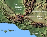
Tejon Pass
Encyclopedia
The Tejon Pass is a mountain pass
at the southwest end of the Tehachapi Mountains
linking Southern
to Central California
.
, north of Gorman
. Its highest point is 4,160 feet (1,268 m) or 4,144 feet (the sources differ), 75 miles northwest of downtown Los Angeles
and 47 miles south of Bakersfield
.
Through it winds the route of Interstate 5, which at this point connects the southern part of the state with the San Joaquin Valley
to the north.
The pass has a mostly gradual rise from its southern approach of 1,362 feet at Santa Clarita
, but a precipitous descent toward the Central Valley on the north, where it ends at the Grapevine
at 1,499 feet.
On its northward slope lies Fort Tejon State Historic Park
, the site of a former U.S. Army post, first garrisoned in 1854.
"would have stopped there when it was the Tataviam
village of Kulshra'jek."
In 1772 Pedro Fages
in pursuit of deserters, crossed the pass and named it Portezuelo de Cortes (Cortes Pass). Fages also named the canyon beyond the pass leading down into the Tulare Basin, Cañada de las Uvas (Canyon of the Grapes) for all the grape vines growing in it.
In 1806, Father Jose Maria Zalvidea, diarist for the expedition of First Lieutenant Francisco Ruiz, into the San Joaquin Valley, named the canyon, creek and pass discovered by padre Francisco Garces
in 1776, "Tejon" (badger
) after a dead badger found at the canyon mouth. This original Tejon Pass, was 15 miles to the northeast of what is now Tejon Pass, in the Tehachapi Mountains, at the top of the divide between Tejon Creek Canyon in the San Joaquin Valley and Cottonwood Creek Canyon in Antelope Valley
.
In 1820, El Camino Viejo
, a road between what is now Oakland and Los Angeles
began to be used to travel north and south in western San Joaquin Valley passed over the pass and turned westward up Cuddy Canyon and down San Emigdio Creek to the San Joaquin Valley. In 1843, Rancho Castac
was established in La Cañada de las Uvas. By the time the Rancho Los Alamos y Agua Caliente
was established in 1846, the pass was called Portezuela de Castac (Castac Pass).
Before 1854, the route of travel into the San Joaquin Valley was directly north from Elizabeth Lake (Laguna de Chico Lopez) across the Antelope Valley, over the original Tejon Pass, into Tejon Canyon and then west along Tejon Creek into the lands of the Rancho Tejon. After the establishment of Fort Tejon and the Stockton - Los Angeles Road
, the Portezuela de Castac began to be called the Fort Tejon Pass. The poor wagon route of the old Tejon Pass route was soon abandoned and the Fort Tejon Pass took the shortened name it has today.
In 1858 the Butterfield Overland Mail
stagecoach line ran through the pass. The Butterfield Overland was discontinued in 1861 but was replaced by the Telegraph Stage Line, which stopped at almost all the former stations, including Gorman's, where the horses were changed. Six of them were used for the pull up from Bakersfield to Gorman's.
The first automobile highway linking the Central Valley with the Los Angeles Basin
, called the Ridge Route
, was laid in a sinuous fashion through the ridges and gullys of the Tejon Pass around 1910. The northern portion of this highway, which became a part of U.S. Route 99, was known as "The Grapevine," after the Cañada de las Uvas, the canyon through which it passed.
, generally because of the icy conditions combined with the steep grade of the pass, and the high traffic during the winter holidays. The Highway Patrol is also concerned that one accident in the snowy conditions might force traffic to slow down or come to a complete stop, leaving hundreds of vehicles to become stalled at once, especially with the number of big-rigs
that pass through. Whenever there is such a closure, traffic must then either wait or endure a multi-hour detour between Bakersfield and Los Angeles (normally a two-hour drive).
. Beginning on the south at Santa Clarita
, it passes through Castaic
, Gorman
, and Lebec
, to end at Grapevine
. It skirts the Tejon Ranch
, where two large planned communities—Centennial
and Tejon Mountain Village
—are proposed.
Mountain pass
A mountain pass is a route through a mountain range or over a ridge. If following the lowest possible route, a pass is locally the highest point on that route...
at the southwest end of the Tehachapi Mountains
Tehachapi Mountains
The Tehachapi Mountains , regionally also called The Tehachapis, are a mountain range in the Transverse Ranges system of California in the Western United States...
linking Southern
Southern California
Southern California is a megaregion, or megapolitan area, in the southern area of the U.S. state of California. Large urban areas include Greater Los Angeles and Greater San Diego. The urban area stretches along the coast from Ventura through the Southland and Inland Empire to San Diego...
to Central California
Central California
Central California, sometimes referenced as Mid-State, is an area of California south of the San Francisco Bay Area and north of Southern California...
.
Geography
The apex of the pass is near the northwesternmost corner of Los Angeles CountyLos Angeles County, California
Los Angeles County is a county in the U.S. state of California. As of 2010 U.S. Census, the county had a population of 9,818,605, making it the most populous county in the United States. Los Angeles County alone is more populous than 42 individual U.S. states...
, north of Gorman
Gorman, California
Gorman, California, is an unincorporated community in northwestern Los Angeles County. As of 2005 it had just 15 homes and a few registered voters, but tens of thousands of motorists traveled through it daily on the Interstate 5 freeway....
. Its highest point is 4,160 feet (1,268 m) or 4,144 feet (the sources differ), 75 miles northwest of downtown Los Angeles
Los Ángeles
Los Ángeles is the capital of the province of Biobío, in the commune of the same name, in Region VIII , in the center-south of Chile. It is located between the Laja and Biobío rivers. The population is 123,445 inhabitants...
and 47 miles south of Bakersfield
Bakersfield, California
Bakersfield is a city near the southern end of the San Joaquin Valley in Kern County, California. It is roughly equidistant between Fresno and Los Angeles, to the north and south respectively....
.
Through it winds the route of Interstate 5, which at this point connects the southern part of the state with the San Joaquin Valley
San Joaquin Valley
The San Joaquin Valley is the area of the Central Valley of California that lies south of the Sacramento – San Joaquin River Delta in Stockton...
to the north.
The pass has a mostly gradual rise from its southern approach of 1,362 feet at Santa Clarita
Santa Clarita, California
Santa Clarita is the fourth largest city in Los Angeles County, California, United States and the twenty-fourth largest city in the state of California. The 2010 US Census reported the city's population grew 16.7% from the year 2000 to 176,320 residents. It is located about northwest of downtown...
, but a precipitous descent toward the Central Valley on the north, where it ends at the Grapevine
Grapevine, California
Grapevine is an unincorporated community in Kern County, California. At an elevation of 1499 feet , the community is located at the foot of a road grade known as The Grapevine through the Grapevine Canyon to Tejon Pass in the Tehachapi Mountains at the southern end of the San Joaquin Valley along...
at 1,499 feet.
On its northward slope lies Fort Tejon State Historic Park
Fort Tejon
Fort Tejon in California is a former United States Army outpost which was intermittently active from June 24, 1854, until September 11, 1864. It is located in the Grapevine Canyon area of Tejon Pass along Interstate 5, the main route through the mountains separating the Central Valley from Los...
, the site of a former U.S. Army post, first garrisoned in 1854.
History
Historian Bonnie Ketterl Kane wrote that Gorman, just south of the crest of the Tejon Pass, is "one of the oldest continuously used roadside rest stops in California," explaining that native AmericansNative Americans in the United States
Native Americans in the United States are the indigenous peoples in North America within the boundaries of the present-day continental United States, parts of Alaska, and the island state of Hawaii. They are composed of numerous, distinct tribes, states, and ethnic groups, many of which survive as...
"would have stopped there when it was the Tataviam
Tataviam
The Tataviam , were called the Alliklik by their neighbors the Chumash , are a Native American group in southern California...
village of Kulshra'jek."
In 1772 Pedro Fages
Pedro Fages
Pere Fages Beleta , nicknamed L'Ós , was a soldier, explorer, and the second Spanish military Governor of Las Californias Province of New Spain from 1770 to 1774, and the Governor of Las Californias from 1782 to 1791.-Life:...
in pursuit of deserters, crossed the pass and named it Portezuelo de Cortes (Cortes Pass). Fages also named the canyon beyond the pass leading down into the Tulare Basin, Cañada de las Uvas (Canyon of the Grapes) for all the grape vines growing in it.
In 1806, Father Jose Maria Zalvidea, diarist for the expedition of First Lieutenant Francisco Ruiz, into the San Joaquin Valley, named the canyon, creek and pass discovered by padre Francisco Garces
Francisco Garcés
Francisco Hermenegildo Tomás Garcés was a Spanish Franciscan missionary who explored much of the southwestern part of North America, including what are now Arizona, southern California, and northeastern Baja California. Garcés was born April 12, 1738, in Morata de Jalón , Zaragoza province,...
in 1776, "Tejon" (badger
Badger
Badgers are short-legged omnivores in the weasel family, Mustelidae. There are nine species of badger, in three subfamilies : Melinae , Mellivorinae , and Taxideinae...
) after a dead badger found at the canyon mouth. This original Tejon Pass, was 15 miles to the northeast of what is now Tejon Pass, in the Tehachapi Mountains, at the top of the divide between Tejon Creek Canyon in the San Joaquin Valley and Cottonwood Creek Canyon in Antelope Valley
Antelope Valley
The Antelope Valley in California, United States, is located in northern Los Angeles County and the southeastern portion of Kern County, California, and constitutes the western tip of the Mojave Desert...
.
In 1820, El Camino Viejo
El Camino Viejo
El Camino Viejo à Los Angeles , also known as the Old Los Angeles Trail, established in 1820's, was the oldest north-south trail in the interior of Alta California...
, a road between what is now Oakland and Los Angeles
Los Ángeles
Los Ángeles is the capital of the province of Biobío, in the commune of the same name, in Region VIII , in the center-south of Chile. It is located between the Laja and Biobío rivers. The population is 123,445 inhabitants...
began to be used to travel north and south in western San Joaquin Valley passed over the pass and turned westward up Cuddy Canyon and down San Emigdio Creek to the San Joaquin Valley. In 1843, Rancho Castac
Rancho Castac
This is an article about a former California rancho. For a community of a similar name in the same general area, see Castaic, California.Rancho Castac or Rancho Castec was a Mexican land grant in present-day Kern and Los Angeles counties, California, made by Governor Manuel Micheltorena to Jose...
was established in La Cañada de las Uvas. By the time the Rancho Los Alamos y Agua Caliente
Rancho Los Alamos y Agua Caliente
Rancho Los Alamos y Agua Caliente was a Mexican land grant in present day Kern County, California given in 1846 by Governor Pio Pico to Francisco Lopes, Luis Jordan and Vicente Botiller. The name means "Cottonwoods and Warm Water Ranch" in Spanish. The native riparian Fremont Cotonwood grow...
was established in 1846, the pass was called Portezuela de Castac (Castac Pass).
Before 1854, the route of travel into the San Joaquin Valley was directly north from Elizabeth Lake (Laguna de Chico Lopez) across the Antelope Valley, over the original Tejon Pass, into Tejon Canyon and then west along Tejon Creek into the lands of the Rancho Tejon. After the establishment of Fort Tejon and the Stockton - Los Angeles Road
Stockton - Los Angeles Road
Stockton-Los Angeles Road, also known as the Millerton Road, Stockton-Mariposa Road, Stockton-Fort Miller Road or the Stockton-Visalia Road was established about 1853 following the discovery of gold on the Kern River in Old Tulare County...
, the Portezuela de Castac began to be called the Fort Tejon Pass. The poor wagon route of the old Tejon Pass route was soon abandoned and the Fort Tejon Pass took the shortened name it has today.
In 1858 the Butterfield Overland Mail
Butterfield Overland Mail
The Butterfield Overland Mail Trail was a stagecoach route in the United States, operating from 1857 to 1861. It was a conduit for the U.S. mail from two eastern termini, Memphis, Tennessee and St. Louis, Missouri, meeting Fort Smith, Arkansas, and continuing through Indian Territory, New Mexico,...
stagecoach line ran through the pass. The Butterfield Overland was discontinued in 1861 but was replaced by the Telegraph Stage Line, which stopped at almost all the former stations, including Gorman's, where the horses were changed. Six of them were used for the pull up from Bakersfield to Gorman's.
The first automobile highway linking the Central Valley with the Los Angeles Basin
Los Angeles Basin
The Los Angeles Basin is the coastal sediment-filled plain located between the Peninsular and Transverse ranges in southern California in the United States containing the central part of the city of Los Angeles as well as its southern and southeastern suburbs...
, called the Ridge Route
Ridge Route
The Ridge Route, officially the Castaic-Tejon Route, was a two-lane highway running between Los Angeles and Kern counties, California. Opened in 1915 and paved with concrete between 1917 and 1921, the road was the first paved highway directly linking the Los Angeles Basin with the San Joaquin...
, was laid in a sinuous fashion through the ridges and gullys of the Tejon Pass around 1910. The northern portion of this highway, which became a part of U.S. Route 99, was known as "The Grapevine," after the Cañada de las Uvas, the canyon through which it passed.
Weather
The pass is sunny in the summer, spring, and fall, but is subject to severe weather and closure to traffic in the winter. The 40-mile stretch of Interstate 5 between Grapevine and Castaic is sometimes closed by the California Highway PatrolCalifornia Highway Patrol
The California Highway Patrol is a law enforcement agency of the U.S. state of California. The CHP has patrol jurisdiction over all California highways and also acts as the state police....
, generally because of the icy conditions combined with the steep grade of the pass, and the high traffic during the winter holidays. The Highway Patrol is also concerned that one accident in the snowy conditions might force traffic to slow down or come to a complete stop, leaving hundreds of vehicles to become stalled at once, especially with the number of big-rigs
Semi-trailer truck
A semi-trailer truck, also known as a semi, tractor-trailer, or articulated truck or articulated lorry, is an articulated vehicle consisting of a towing engine , and a semi-trailer A semi-trailer truck, also known as a semi, tractor-trailer, or (in the United Kingdom and Ireland) articulated truck...
that pass through. Whenever there is such a closure, traffic must then either wait or endure a multi-hour detour between Bakersfield and Los Angeles (normally a two-hour drive).
Communities
This historic gap has given its name to the Mountain Communities of the Tejon PassMountain Communities of the Tejon Pass
The Mountain Communities of the Tejon Pass, or the Frazier Mountain Communities, in the San Emigdio Mountains is a region of California that includes Lebec, Frazier Park, Lake of the Woods, Lockwood Valley, Pinon Pines, and Pine Mountain Club, in Kern County, California, and Gorman in Los Angeles...
. Beginning on the south at Santa Clarita
Santa Clarita, California
Santa Clarita is the fourth largest city in Los Angeles County, California, United States and the twenty-fourth largest city in the state of California. The 2010 US Census reported the city's population grew 16.7% from the year 2000 to 176,320 residents. It is located about northwest of downtown...
, it passes through Castaic
Castaic, California
Castaic, California, is an unincorporated community and census-designated place in Los Angeles County, California, north of Santa Clarita and a few miles from Six Flags Magic Mountain amusement park. It is approximately 39 miles from the downtown Los Angeles Civic Center. As of the 2010...
, Gorman
Gorman, California
Gorman, California, is an unincorporated community in northwestern Los Angeles County. As of 2005 it had just 15 homes and a few registered voters, but tens of thousands of motorists traveled through it daily on the Interstate 5 freeway....
, and Lebec
Lebec, California
Lebec is an unincorporated area and census-designated place in Kern County, California. It is one of the Mountain Communities of the Tejon Pass, and the home of the Tejon Ranch Company. Lebec is south of Bakersfield. The population was 1,468 in the 2010 census, up from 1,224 in...
, to end at Grapevine
Grapevine, California
Grapevine is an unincorporated community in Kern County, California. At an elevation of 1499 feet , the community is located at the foot of a road grade known as The Grapevine through the Grapevine Canyon to Tejon Pass in the Tehachapi Mountains at the southern end of the San Joaquin Valley along...
. It skirts the Tejon Ranch
Tejon Ranch
The Tejon Ranch Company , based in Lebec, California, is one of the largest private landowners in California. [The federally-gifted lands still held by the Catellus Corporation, a successor to the Southern Pacific Land Company, are much more extensive.] It was incorporated in 1936 to organise the...
, where two large planned communities—Centennial
Centennial, California
Centennial, California, is a proposed planned community between Bakersfield and Los Angeles in Los Angeles County located north of Highway 138, and just east of Interstate 5; specifically, surrounding the north and east sides of Quail Lake...
and Tejon Mountain Village
Tejon Mountain Village
Tejon Mountain Village is a proposed residential, commercial, and recreational development of pristine, rugged property in the Tehachapi Mountains owned by the Tejon Ranch Company in Lebec, southern Kern County, California. The development includes the largest conservation and land-use agreement in...
—are proposed.
External links
- Map and profile of the Tejon Pass : from explorations and surveys / made under the direction of the Hon. Jefferson Davis, Secretary of War by Lieut. R. S. Williamson, Topl. Engrs. assisted by Lieut. J. G. Parke, Topl. Engrs. and Mr. Isaac Williams Smith, Civ. Engr., 1853
- Map and profile of the Canada de las Uvas : from explorations and surveys / made under the direction of the Hon. Jefferson Davis, Secretary of War by Lieut. R. S. Williamson. Topl. Engrs. assisted by Lieut. J. G. Parke. Topl. Engrs. and Mr. Isaac Williams Smith, Civ. Engr., 1853.
- Passes in the Sierra Nevada from Walker's Pass to the Coast Range : from explorations and surveys / made under the direction of the Hon. Jefferson Davis, Secretary of War by Lieut. R. S. Williamson Topl. Engr. assisted by Lieut. J. G. Parke Topl. Engr. and Mr. Isaac Williams Smith, Civ. Engr., 1853.
- California Department of Transportation - Current road closures