

Muhammad al-Idrisi
Encyclopedia
Islamic geography
Geography and cartography in medieval Islam refers to the advancement of geography, cartography and the earth sciences in the medieval Islamic civilization....
, cartographer
Cartography
Cartography is the study and practice of making maps. Combining science, aesthetics, and technique, cartography builds on the premise that reality can be modeled in ways that communicate spatial information effectively.The fundamental problems of traditional cartography are to:*Set the map's...
, Egyptologist
Egyptology
Egyptology is the study of ancient Egyptian history, language, literature, religion, and art from the 5th millennium BC until the end of its native religious practices in the AD 4th century. A practitioner of the discipline is an “Egyptologist”...
and traveller who lived in Sicily
Sicily
Sicily is a region of Italy, and is the largest island in the Mediterranean Sea. Along with the surrounding minor islands, it constitutes an autonomous region of Italy, the Regione Autonoma Siciliana Sicily has a rich and unique culture, especially with regard to the arts, music, literature,...
, at the court of King Roger II
Roger II of Sicily
Roger II was King of Sicily, son of Roger I of Sicily and successor to his brother Simon. He began his rule as Count of Sicily in 1105, later became Duke of Apulia and Calabria , then King of Sicily...
. Muhammed al-Idrisi was born in Ceuta
Ceuta
Ceuta is an autonomous city of Spain and an exclave located on the north coast of North Africa surrounded by Morocco. Separated from the Iberian peninsula by the Strait of Gibraltar, Ceuta lies on the border of the Mediterranean Sea and the Atlantic Ocean. Ceuta along with the other Spanish...
then belonging to the Almoravid Empire
Almoravids
The Almoravids were a Berber dynasty of Morocco, who formed an empire in the 11th-century that stretched over the western Maghreb and Al-Andalus. Their capital was Marrakesh, a city which they founded in 1062 C.E...
and died in Sicily
Sicily
Sicily is a region of Italy, and is the largest island in the Mediterranean Sea. Along with the surrounding minor islands, it constitutes an autonomous region of Italy, the Regione Autonoma Siciliana Sicily has a rich and unique culture, especially with regard to the arts, music, literature,...
. Al Idrisi was a descendent of the Idrisids, who in turn were descendants of Hasan bin Ali, the son of Ali
Ali
' |Ramaḍān]], 40 AH; approximately October 23, 598 or 600 or March 17, 599 – January 27, 661).His father's name was Abu Talib. Ali was also the cousin and son-in-law of the Islamic prophet Muhammad, and ruled over the Islamic Caliphate from 656 to 661, and was the first male convert to Islam...
and the grandson of the Islamic prophet
Prophets of Islam
Muslims identify the Prophets of Islam as those humans chosen by God and given revelation to deliver to mankind. Muslims believe that every prophet was given a belief to worship God and their respective followers believed it as well...
Muhammad
Muhammad
Muhammad |ligature]] at U+FDF4 ;Arabic pronunciation varies regionally; the first vowel ranges from ~~; the second and the last vowel: ~~~. There are dialects which have no stress. In Egypt, it is pronounced not in religious contexts...
.
Early life
Al-Idrisi traced his descent through long line of Princes, Caliphs and Sufi leaders, to The Prophet Muhammad. His immediate forebears, the Hammudids (1016–1058), were an offshoot of the IdrisidIdrisid
The Idrisids were a Zaydi-Shia dynasty of Arab origins in Morocco, ruling from 788 to 985, named after its first leader, Idriss I.-History:...
s (789-985).
Al-Idrisi's was born in Ceuta
Ceuta
Ceuta is an autonomous city of Spain and an exclave located on the north coast of North Africa surrounded by Morocco. Separated from the Iberian peninsula by the Strait of Gibraltar, Ceuta lies on the border of the Mediterranean Sea and the Atlantic Ocean. Ceuta along with the other Spanish...
, where his great-grandfather had fled after the fall of Málaga
Málaga
Málaga is a city and a municipality in the Autonomous Community of Andalusia, Spain. With a population of 568,507 in 2010, it is the second most populous city of Andalusia and the sixth largest in Spain. This is the southernmost large city in Europe...
in Al-Andalus
Al-Andalus
Al-Andalus was the Arabic name given to a nation and territorial region also commonly referred to as Moorish Iberia. The name describes parts of the Iberian Peninsula and Septimania governed by Muslims , at various times in the period between 711 and 1492, although the territorial boundaries...
(1057). He spent much of his early life travelling through North Africa
North Africa
North Africa or Northern Africa is the northernmost region of the African continent, linked by the Sahara to Sub-Saharan Africa. Geopolitically, the United Nations definition of Northern Africa includes eight countries or territories; Algeria, Egypt, Libya, Morocco, South Sudan, Sudan, Tunisia, and...
, and Spain
Spain
Spain , officially the Kingdom of Spain languages]] under the European Charter for Regional or Minority Languages. In each of these, Spain's official name is as follows:;;;;;;), is a country and member state of the European Union located in southwestern Europe on the Iberian Peninsula...
and seems to have acquired a detail information on both regions. He visited Anatolia
Anatolia
Anatolia is a geographic and historical term denoting the westernmost protrusion of Asia, comprising the majority of the Republic of Turkey...
when he was barely 16. He is known to have studied in Córdoba
Córdoba, Spain
-History:The first trace of human presence in the area are remains of a Neanderthal Man, dating to c. 32,000 BC. In the 8th century BC, during the ancient Tartessos period, a pre-urban settlement existed. The population gradually learned copper and silver metallurgy...
, and later taught in Constantine
Constantine, Algeria
Constantine is the capital of Constantine Province in north-eastern Algeria. It was the capital of the same-named French département until 1962. Slightly inland, it is about 80 kilometres from the Mediterranean coast, on the banks of Rhumel river...
, Algeria
Algeria
Algeria , officially the People's Democratic Republic of Algeria , also formally referred to as the Democratic and Popular Republic of Algeria, is a country in the Maghreb region of Northwest Africa with Algiers as its capital.In terms of land area, it is the largest country in Africa and the Arab...
.
Apparently his travels took him to many parts of Europe
Europe
Europe is, by convention, one of the world's seven continents. Comprising the westernmost peninsula of Eurasia, Europe is generally 'divided' from Asia to its east by the watershed divides of the Ural and Caucasus Mountains, the Ural River, the Caspian and Black Seas, and the waterways connecting...
including Portugal
Portugal
Portugal , officially the Portuguese Republic is a country situated in southwestern Europe on the Iberian Peninsula. Portugal is the westernmost country of Europe, and is bordered by the Atlantic Ocean to the West and South and by Spain to the North and East. The Atlantic archipelagos of the...
, the Pyrenees
Pyrenees
The Pyrenees is a range of mountains in southwest Europe that forms a natural border between France and Spain...
, the French
France
The French Republic , The French Republic , The French Republic , (commonly known as France , is a unitary semi-presidential republic in Western Europe with several overseas territories and islands located on other continents and in the Indian, Pacific, and Atlantic oceans. Metropolitan France...
Atlantic coast, Hungary
Hungary
Hungary , officially the Republic of Hungary , is a landlocked country in Central Europe. It is situated in the Carpathian Basin and is bordered by Slovakia to the north, Ukraine and Romania to the east, Serbia and Croatia to the south, Slovenia to the southwest and Austria to the west. The...
, and Jórvík
Jórvík
Scandinavian York is a term, like the terms Kingdom of Jórvík or Kingdom of York, used by historians for the kingdom of Northumbria in the late 9th century and first half of the 10th century, when it was dominated by Norse warrior-kings; in particular, it is used to refer to the city controlled by...
also known as York
York
York is a walled city, situated at the confluence of the Rivers Ouse and Foss in North Yorkshire, England. The city has a rich heritage and has provided the backdrop to major political events throughout much of its two millennia of existence...
, in England
England
England is a country that is part of the United Kingdom. It shares land borders with Scotland to the north and Wales to the west; the Irish Sea is to the north west, the Celtic Sea to the south west, with the North Sea to the east and the English Channel to the south separating it from continental...
.
Tabula Rogeriana
Born and raised in CeutaCeuta
Ceuta is an autonomous city of Spain and an exclave located on the north coast of North Africa surrounded by Morocco. Separated from the Iberian peninsula by the Strait of Gibraltar, Ceuta lies on the border of the Mediterranean Sea and the Atlantic Ocean. Ceuta along with the other Spanish...
, at an early age al-Idrisi travelled to Islamic Spain, Portugal, France and England, and visited Anatolia when he was barely 16. Because of conflict and instability in Andalusia al-Idrisi joined contemporaries such as Abu al-Salt
Abu al-Salt
Abū al‐Ṣalt, Umayya ibn ʿAbd al‐ʿAzīz ibn Abī al‐Ṣalt al‐Dānī al‐Andalusī was an Andalusian polymath whose works on astronomical instruments were read both in the Islamic world and Europe. He also worked as a physician, a teacher of alchemy, and wrote treatises on medicine, philosophy, music, and...
in Sicily
Sicily
Sicily is a region of Italy, and is the largest island in the Mediterranean Sea. Along with the surrounding minor islands, it constitutes an autonomous region of Italy, the Regione Autonoma Siciliana Sicily has a rich and unique culture, especially with regard to the arts, music, literature,...
, where the Normans had overthrown Arabs formerly loyal to the Fatimid
Fatimid
The Fatimid Islamic Caliphate or al-Fāṭimiyyūn was a Berber Shia Muslim caliphate first centered in Tunisia and later in Egypt that ruled over varying areas of the Maghreb, Sudan, Sicily, the Levant, and Hijaz from 5 January 909 to 1171.The caliphate was ruled by the Fatimids, who established the...
s. According to Ibn Jubayr
Ibn Jubayr
Ibn Jubayr was a geographer, traveler and poet from al-Andalus.-Early life:Born in Valencia in Spain, then the seat of an independent emirate. Ibn Jubayr was descendant of a tribe of Andalusian origins, Jubayr was the son of a civil servant...
: "the Normans tolerated and patronized a few Arab families in exchange for knowledge"
Al-Idrisi incorporated the knowledge of Africa
Africa
Africa is the world's second largest and second most populous continent, after Asia. At about 30.2 million km² including adjacent islands, it covers 6% of the Earth's total surface area and 20.4% of the total land area...
, the Indian Ocean
Indian Ocean
The Indian Ocean is the third largest of the world's oceanic divisions, covering approximately 20% of the water on the Earth's surface. It is bounded on the north by the Indian Subcontinent and Arabian Peninsula ; on the west by eastern Africa; on the east by Indochina, the Sunda Islands, and...
and the Far East
Far East
The Far East is an English term mostly describing East Asia and Southeast Asia, with South Asia sometimes also included for economic and cultural reasons.The term came into use in European geopolitical discourse in the 19th century,...
gathered by Islamic merchants
Islamic economics in the world
Islamic economics in practice, or economic policies supported by self-identified Islamic groups, has varied throughout its long history. Traditional Islamic concepts having to do with economics included...
and explorers and recorded on Islamic maps, with the information brought by the Normans voyagers to create the most accurate map of the world in pre-modern times, which served as a concrete illustration of his Kitab nuzhat al-mushtaq, (Latin: Opus Geographicum), which may be translated A Diversion for the Man Longing to Travel to Far-Off Places.
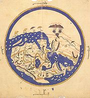
The Tabula Rogeriana
Tabula Rogeriana
The Nuzhat al-mushtaq fi'khtiraq al-afaq lit. "the book of pleasant journeys into faraway lands", most often known as the Tabula Rogeriana , is a description of the world and world map created by the Arab geographer, Muhammad al-Idrisi, in 1154...
was drawn by Al-Idrisi in 1154 for the Norman King Roger II of Sicily
Roger II of Sicily
Roger II was King of Sicily, son of Roger I of Sicily and successor to his brother Simon. He began his rule as Count of Sicily in 1105, later became Duke of Apulia and Calabria , then King of Sicily...
, after a stay of eighteen years at his court, where he worked on the commentaries and illustrations of the map. The map, with legends written in Arabic, while showing the Eurasia
Eurasia
Eurasia is a continent or supercontinent comprising the traditional continents of Europe and Asia ; covering about 52,990,000 km2 or about 10.6% of the Earth's surface located primarily in the eastern and northern hemispheres...
n continent in its entirety, only shows the northern part
North Africa
North Africa or Northern Africa is the northernmost region of the African continent, linked by the Sahara to Sub-Saharan Africa. Geopolitically, the United Nations definition of Northern Africa includes eight countries or territories; Algeria, Egypt, Libya, Morocco, South Sudan, Sudan, Tunisia, and...
of the African continent and lacks details of the Horn of Africa
Horn of Africa
The Horn of Africa is a peninsula in East Africa that juts hundreds of kilometers into the Arabian Sea and lies along the southern side of the Gulf of Aden. It is the easternmost projection of the African continent...
and Southeast Asia.
For Roger it was inscribed on a massive disc of solid silver, two metres in diameter.
On the geographical work of al-Idrisi, S.P. Scott wrote in 1904:
Al-Idrisi inspired Islamic geographers such as Ibn Battuta
Ibn Battuta
Abu Abdullah Muhammad Ibn Battuta , or simply Ibn Battuta, also known as Shams ad–Din , was a Muslim Moroccan Berber explorer, known for his extensive travels published in the Rihla...
, Ibn Khaldun
Ibn Khaldun
Ibn Khaldūn or Ibn Khaldoun was an Arab Tunisian historiographer and historian who is often viewed as one of the forerunners of modern historiography, sociology and economics...
and Piri Reis
Piri Reis
Piri Reis was an Turkish Ottoman admiral, geographer and cartographer born between 1465 and 1470 and died in 1554 or 1555....
. His map also inspired Christopher Columbus
Christopher Columbus
Christopher Columbus was an explorer, colonizer, and navigator, born in the Republic of Genoa, in northwestern Italy. Under the auspices of the Catholic Monarchs of Spain, he completed four voyages across the Atlantic Ocean that led to general European awareness of the American continents in the...
and Vasco Da Gama
Vasco da Gama
Vasco da Gama, 1st Count of Vidigueira was a Portuguese explorer, one of the most successful in the Age of Discovery and the commander of the first ships to sail directly from Europe to India...
.
Nuzhatul Mushtaq
.jpg)
Publication and translation
An abridged version of the Arabic text was published in Rome in 1592 with title: De geographia universali or Kitāb Nuzhat al-mushtāq fī dhikr al-amṣār wa-al-aqṭār wa-al-buldān wa-al-juzur wa-al-madā’ in wa-al-āfāq which in English would be Recreation of the desirer in the account of cities, regions, countries, islands, towns, and distant lands. This was one of the first Arabic books ever printed. The first translation from the original Arabic was into Latin. The Maronites Gabriel Sionita and Joannes Hesronita translated an abridged version of the text which was published in Paris in 1619 with the rather misleading title of Geographia nubiensis. Not until the middle of the 19th century was a complete translation of the Arabic text published. This was a translation into French by Pierre Amédée JaubertPierre Amédée Jaubert
Pierre Amédée Emilien Probe Jaubert was a French diplomat, academic, orientalist, translator, politician, and traveler. He was Napoleon's "favourite orientalist adviser and dragoman".-Biography:...
. More recently sections of the text have been translated for particular regions. In the 1970s a critical edition of the complete Arabic text was published.
Andalusian-American contact
Al-Idrisi's geographical text, Nuzhatul Mushtaq, is often cited by proponents of pre-Columbian Andalusian-Americas contact theories. In this text, al-Idrisi wrote the following on the Atlantic OceanAtlantic Ocean
The Atlantic Ocean is the second-largest of the world's oceanic divisions. With a total area of about , it covers approximately 20% of the Earth's surface and about 26% of its water surface area...
:
This translation by Professor Muhammad Hamidullah
Muhammad Hamidullah
Muhammad Hamidullah or Muhammad Hameedullah, D. Phil., D. Litt., HI., was a Hyderabadi from Hyderabad State , Muhaddith, Faqih, scholar of Islam and International Law, and foremost a prolific academic author Muhammad Hamidullah or Muhammad Hameedullah, D. Phil., D. Litt., HI., (Urdu: محمد...
is however questionable, since it reports, after having reached an area of "sticky and stinking waters", the Mugharrarin (also translated as "the adventurers") moved back and first reached an uninhabited island where they found "a huge quantity of sheep the meat of which was bitter and uneatable" and, then, "continued southward" and reached the above reported island where they were soon surrounded by barques and brought to "a village whose inhabitants were often fair-haired with long and flaxen hair and the women of a rare beauty". Among the villagers, one spoke Arabic and asked them where they came from. Then the king of the village ordered them to bring them back to the continent where they were surprised to be welcomed by Berbers.
Apart from the marvellous and fanciful reports of this history, the most probable interpretation is that the Mugharrarin reached the Sargasso Sea
Sargasso Sea
The Sargasso Sea is a region in the middle of the North Atlantic Ocean, surrounded by ocean currents. It is bounded on the west by the Gulf Stream; on the north, by the North Atlantic Current; on the east, by the Canary Current; and on the south, by the North Atlantic Equatorial Current. This...
, a part of the ocean covered by seaweed
Seaweed
Seaweed is a loose, colloquial term encompassing macroscopic, multicellular, benthic marine algae. The term includes some members of the red, brown and green algae...
) which is very close to Bermuda
Bermuda
Bermuda is a British overseas territory in the North Atlantic Ocean. Located off the east coast of the United States, its nearest landmass is Cape Hatteras, North Carolina, about to the west-northwest. It is about south of Halifax, Nova Scotia, Canada, and northeast of Miami, Florida...
yet one thousand miles away from the American mainland. Then while coming back, they may have landed either on the Azores
Azores
The Archipelago of the Azores is composed of nine volcanic islands situated in the middle of the North Atlantic Ocean, and is located about west from Lisbon and about east from the east coast of North America. The islands, and their economic exclusion zone, form the Autonomous Region of the...
, or on Madeira
Madeira
Madeira is a Portuguese archipelago that lies between and , just under 400 km north of Tenerife, Canary Islands, in the north Atlantic Ocean and an outermost region of the European Union...
or even on the westernmost Canary Island
Canary Islands
The Canary Islands , also known as the Canaries , is a Spanish archipelago located just off the northwest coast of mainland Africa, 100 km west of the border between Morocco and the Western Sahara. The Canaries are a Spanish autonomous community and an outermost region of the European Union...
, Hiero
Hiero
Hiero may refer to:* Hiero, a dialogue by Xenophon* Hiero I, tyrant of Syracuse, Italy * Hiero II, tyrant of Syracuse * Hiero Desteen, protagonist of two post-apocalypse novels by Sterling E...
(because of the sheep). Last, the story with the inhabited island might have occurred either on Tenerife
Tenerife
Tenerife is the largest and most populous island of the seven Canary Islands, it is also the most populated island of Spain, with a land area of 2,034.38 km² and 906,854 inhabitants, 43% of the total population of the Canary Islands. About five million tourists visit Tenerife each year, the...
or on Gran Canaria
Gran Canaria
Gran Canaria is the second most populous island of the Canary Islands, with a population of 838,397 which constitutes approximately 40% of the population of the archipelago...
, where the Mugharrarin presumably met some Guanche
Guanches
Guanches is the name given to the aboriginal Berber inhabitants of the Canary Islands. It is believed that they migrated to the archipelago sometime between 1000 BCE and 100 BCE or perhaps earlier...
tribe. This would explain why some of them could speak Arabic (some sporadic contacts had been maintained between the Canary Islands and Morocco) and why they were quickly deported to Morocco where they were welcomed by Berbers. Yet, the story reported by Idrisi is an indisputable account of a certain knowledge of the Atlantic Ocean by the Arabs and by their Andalusian and Moroccan vassals.
In popular culture
- Al Idrisi is the main character in Tariq AliTariq AliTariq Ali , , is a British Pakistani military historian, novelist, journalist, filmmaker, public intellectual, political campaigner, activist, and commentator...
's book entitled A Sultan in Palermo. - Al Idrisi is the title character in Jon Fasman's book entitled The Geographer's Library.
- Al-Idrisi's works had a profound influence on European writers such as: Marino Sanuto the ElderMarino Sanuto the ElderMarino Sanuto or Sanudo the Elder of Torcello was a Venetian statesman and geographer.He is best known for his life-long attempts to revive the crusading spirit and movement; with this object he wrote his great work, the Secreta Fidelium Crucis, otherwise called Historia Hierosolymitana, Liber de...
, Antonio MalfanteAntonio MalfanteAntonio Malfante was a Genoese trader, known for traveling to Africa on behalf of the Centurione Bank in 1447. In a letter written in Latin from the Saharan oasis of Tuwat to a merchant in Genoa, Malfante reported on what he learned from an informant about the trans-Saharan trade...
, Jaume FerrerJaume FerrerJaume Ferrer was a Majorcan sailor and explorer.Practically nothing is known of Jaume Ferrer, save that he was a Majorcan captain, who set out in a galley in 1346, and sailed down the West African coast in an attempt to reach the legendary "River of Gold". The results of this expedition, including...
and Alonso Fernández de LugoAlonso Fernández de LugoJavier Alonso Luis Fernández de Lugo was a Spanish military man, conquistador, city founder, and administrator. He conquered the islands of La Palma and Tenerife for the Castilian Crown; they were the last of the Canary Islands to be conquered by Europeans. He was also the founder of the towns...
.
The popular IDRISI
IDRISI
IDRISI is an integrated geographic information system and remote sensing software developed by Clark Labs at Clark University for the analysis and display of digital geospatial information...
GIS system, developed by Clark University, is named after Muhammad al-Idrisi
See also
- Al-Bakri
- Ibn JubayrIbn JubayrIbn Jubayr was a geographer, traveler and poet from al-Andalus.-Early life:Born in Valencia in Spain, then the seat of an independent emirate. Ibn Jubayr was descendant of a tribe of Andalusian origins, Jubayr was the son of a civil servant...
- Abu al-SaltAbu al-SaltAbū al‐Ṣalt, Umayya ibn ʿAbd al‐ʿAzīz ibn Abī al‐Ṣalt al‐Dānī al‐Andalusī was an Andalusian polymath whose works on astronomical instruments were read both in the Islamic world and Europe. He also worked as a physician, a teacher of alchemy, and wrote treatises on medicine, philosophy, music, and...
- History of cartographyHistory of cartographyCartography , or mapmaking, has been an integral part of the human story for a long time, possibly up to 8,000 years...
- Islamic geographyIslamic geographyGeography and cartography in medieval Islam refers to the advancement of geography, cartography and the earth sciences in the medieval Islamic civilization....
- List of Arab scientists
- Tabula RogerianaTabula RogerianaThe Nuzhat al-mushtaq fi'khtiraq al-afaq lit. "the book of pleasant journeys into faraway lands", most often known as the Tabula Rogeriana , is a description of the world and world map created by the Arab geographer, Muhammad al-Idrisi, in 1154...
- Roger I of SicilyRoger I of SicilyRoger I , called Bosso and the Great Count, was the Norman Count of Sicily from 1071 to 1101. He was the last great leader of the Norman conquest of southern Italy.-Conquest of Calabria and Sicily:...
External links
- BNF (Bibliothèque Nationale de France) http://mandragore.bnf.fr/jsp/rechercheExperte.jsp type "Arabe 2221" in the box "Cote", then hit "chercher", then "Images" for images of the manuscript of al-Idrisi
- Profile at IslamOnline
- Britannica
- Online exhibition, Bibliothèque nationale de FranceBibliothèque nationale de FranceThe is the National Library of France, located in Paris. It is intended to be the repository of all that is published in France. The current president of the library is Bruno Racine.-History:...
(French) - Idrisi's world map, Library of CongressLibrary of CongressThe Library of Congress is the research library of the United States Congress, de facto national library of the United States, and the oldest federal cultural institution in the United States. Located in three buildings in Washington, D.C., it is the largest library in the world by shelf space and...
. Konrad Miller's 1927 consolidation and transliteration, with high-resolution zoom browser. - Online Galleries, History of Science Collections, University of Oklahoma Libraries High resolution images of works by al-Idrisi in .jpg and .tiff format.
- IDRISI GIS home page