

List of nature parks in Germany
Encyclopedia
Ninety eight official nature parks have been established in Germany
under section 22, paragraph 4 of that country's Federal Nature Conservation Act (BNatSchG). They comprise about 25 percent of the total land area of Germany and are brought together under the Association of German Nature Parks. Parks that overlap into neighbouring countries are led by Europarc. The oldest is Lüneburg Heath Nature Park
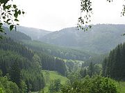
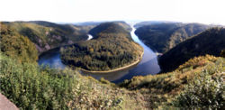
, whose core area was established in 1921 as a nature reserve; by 2007 it had expanded to more than four times its original area. The largest nature reserve in Germany, with 3750 square kilometre is the Nature Park of the Central and Northern Black Forest
and the smallest is Siebengebirge
with an area of 48 square kilometre.
The 14 national parks of Germany, under paragraph 24 of the Federal Nature Conservation Act, are not listed here. See List of national parks of Germany.
Germany
Germany , officially the Federal Republic of Germany , is a federal parliamentary republic in Europe. The country consists of 16 states while the capital and largest city is Berlin. Germany covers an area of 357,021 km2 and has a largely temperate seasonal climate...
under section 22, paragraph 4 of that country's Federal Nature Conservation Act (BNatSchG). They comprise about 25 percent of the total land area of Germany and are brought together under the Association of German Nature Parks. Parks that overlap into neighbouring countries are led by Europarc. The oldest is Lüneburg Heath Nature Park
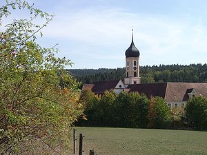
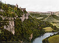
Lüneburg Heath Nature Park
In the north of the area known as the Lüneburg Heath in northern Germany, lies the Lüneburg Heath Nature Park with an area of...
, whose core area was established in 1921 as a nature reserve; by 2007 it had expanded to more than four times its original area. The largest nature reserve in Germany, with 3750 square kilometre is the Nature Park of the Central and Northern Black Forest
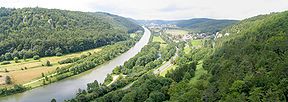
Black Forest
The Black Forest is a wooded mountain range in Baden-Württemberg, southwestern Germany. It is bordered by the Rhine valley to the west and south. The highest peak is the Feldberg with an elevation of 1,493 metres ....
and the smallest is Siebengebirge
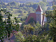
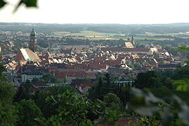
Siebengebirge
The Siebengebirge is a German range of hills to the East of the Rhine, southeast of Bonn, consisting of more than 40 mountains and hills. It is located in the municipalities of Bad Honnef and Königswinter. It is of volcanic origin and came into being between 28 and 15 million years ago...
with an area of 48 square kilometre.
The 14 national parks of Germany, under paragraph 24 of the Federal Nature Conservation Act, are not listed here. See List of national parks of Germany.
Nature parks
| Name | State |
Year |
Area (km²) |
Summary | Image |
|---|---|---|---|---|---|
| Altmühl Altmühl The Altmühl is a river in Bavaria, Germany. It is a left tributary of the Danube and is approximately 230 km in length.The source of the Altmühl is located close to the city of Ansbach. From here the river runs southeastwards as a narrow brook to enter the Altmühlsee north of Gunzenhausen... Valley |
 Kingdom of Bavaria Kingdom of Bavaria |
1969 | 2962 | The park is characterized by gently undulating plateaus and steep valleys with precipitous cliffs, and half of the park is wooded. The Altmühl Altmühl The Altmühl is a river in Bavaria, Germany. It is a left tributary of the Danube and is approximately 230 km in length.The source of the Altmühl is located close to the city of Ansbach. From here the river runs southeastwards as a narrow brook to enter the Altmühlsee north of Gunzenhausen... flows through a spectacular valley from west to east. |
 |
| Arnsberg Forest Nature Park Arnsberg Forest Nature Park The Arnsberg Forest Nature Park is a nature park in the districts of Hochsauerlandkreis and Soest within the administrictive region of Arnsberg in the German state of North Rhine-Westphalia... |
 North Rhine-Westphalia North Rhine-Westphalia |
1961 | 482 | The park includes the Arnsberg Forest in the west and the Warstein Forest in the east. It is an area of low, forested mountains with several ridge Ridge A ridge is a geological feature consisting of a chain of mountains or hills that form a continuous elevated crest for some distance. Ridges are usually termed hills or mountains as well, depending on size. There are several main types of ridges:... s. It is bordered by the Möhne Möhne The Möhne is a small-size river in western Germany , right tributary of the Ruhr. The Möhne passes the towns of Brilon, Rüthen, Warstein. There is large articifical lake near the mouth of the river, the Möhne Reservoir, used for hydro power generation and leisure activities.... in the north and the valley cut by the Ruhr in the south. |
|
| Augsburg-Western Woods Nature Park | Kingdom of Bavaria |
1974 | 1175 | This park is bordered by the Danube Danube The Danube is a river in the Central Europe and the Europe's second longest river after the Volga. It is classified as an international waterway.... , Wertach Wertach River The Wertach is a river in Bavaria, southern Germany, left tributary of the Lech. Its total length is 151 km. The Wertach originates in the Northern Limestone Alps, in Bad Hindelang, east of Sonthofen . It flows north along the towns Wertach, Nesselwang, Marktoberdorf, Kaufbeuren, Schwabmünchen and... , Schmutter Schmutter The Schmutter is a river in Bavaria, Germany, a right tributary of the Danube. Its source is 6 km southwest of Schwabmünchen, in the Swabia region of Bavaria. It flows north, and for several tens of kilometers it flows parallel to the Lech, at only a few km west of the Lech. It flows into the... , Flossach Flossach Flossach is a river of Bavaria, Germany.... and Mindel Mindel The Mindel is a river in Bavaria, southern Germany. The Mindel originates west of Kaufbeuren, in the Allgäu region, and flows generally north. It flows into the Danube in Gundremmingen, east of Günzburg. The towns Mindelheim, Burgau and Thannhausen lie along the Mindel.The Mindel gave its name to... . The biggest part of the nature park is located in Augsburg (district) Augsburg (district) Augsburg is a district in Bavaria, Germany. It is bounded by the city of Augsburg and the districts of Aichach-Friedberg, Landsberg, Ostallgäu, Unterallgäu, Günzburg, Dillingen and Donau-Ries... and extends to the edge of the districts Unterallgäu Unterallgäu Unterallgäu is a Kreis in the southwestern part of Bavaria, Germany. Neighboring districts are Neu-Ulm, Günzburg, Augsburg, Ostallgäu, Oberallgäu, and the districts Ravensburg und Biberach in Baden-Württemberg. The district-free city Memmingen in the west of the district is nearly surrounded by... , Günzburg (district) Günzburg (district) Günzburg is a district in Bavaria, Germany. It is bounded by the districts of Dillingen, Augsburg, Unterallgäu and Neu-Ulm, and by the state of Baden-Württemberg .... and Dillingen (district) Dillingen (district) Dillingen is a district in Bavaria, Germany. It is bounded by the districts of Donau-Ries, Augsburg and Günzburg, and by the state of Baden-Württemberg .-History:... . The gentle, hilly landscape of streams is fragmented by the gravel left behind by ice age Ice age An ice age or, more precisely, glacial age, is a generic geological period of long-term reduction in the temperature of the Earth's surface and atmosphere, resulting in the presence or expansion of continental ice sheets, polar ice sheets and alpine glaciers... Alpine glaciers and is nearly half forested. |
 |
| Aukrug Aukrug Aukrug is a municipality in the district of Rendsburg-Eckernförde, in Schleswig-Holstein, Germany. It is situated approx. 13 km west of Neumünster, and 35 km southwest of Kiel.-Overview:... |
 Schleswig-Holstein Schleswig-Holstein |
1970 | 384 | The park includes a flat and loamy ground moraine landscape with low hills and forests. In the south, the landscape is shaped by the Stör Stör The Stör is a river in Schleswig-Holstein, Germany, right tributary of the Elbe. Its total length is 87 km. The Stör rises east of Neumünster, and flows west through Neumünster, Kellinghusen, and Itzehoe. The Stör joins the Elbe near Glückstadt.... River, with moraines, heath Heath (habitat) A heath or heathland is a dwarf-shrub habitat found on mainly low quality acidic soils, characterised by open, low growing woody vegetation, often dominated by plants of the Ericaceae. There are some clear differences between heath and moorland... , forest, and numerous ponds. |
|
| Barnim Nature Park Barnim Nature Park Barnim Nature Park is a nature park and reserve in the state of Brandenburg, and partly in Berlin, Germany. It covers an area of 750 km² . It was established on September 24, 1998.-Overview:... |
 Brandenburg Brandenburg Berlin Berlin |
1999 | 749 | The park includes the Barnim Barnim Barnim is a district in Brandenburg, Germany. It is bounded by Poland, the district of Märkisch-Oderland, the city state of Berlin and the districts of Oberhavel and Uckermark.- History :... heath habitats dating back to the ice age. It lies between the glacial valleys of Eberswalde Eberswalde Eberswalde is a major town and the administrative seat of the district Barnim in the German Federal State of Brandenburg, about 50 km northeast of Berlin. Population 42144 , geographical location . The town is often called Waldstadt , because of the large forests around it, including the... in the north and Berlin Berlin Berlin is the capital city of Germany and is one of the 16 states of Germany. With a population of 3.45 million people, Berlin is Germany's largest city. It is the second most populous city proper and the seventh most populous urban area in the European Union... in the south, and is more than half forested. The region is shaped by many individual lakes and meltwater gullies. |
 |
| Bavarian Rhön Nature Park Bavarian Rhön Nature Park The Bavarian Rhön Nature Park straddles the junction of the German states of Bavaria,Hesse and Thuringia. 70 km² of the total 125 km² area of the nature park has been recognised by UNESCO as part of the Rhön Biosphere Reserve.... |
Kingdom of Bavaria |
1967 | 1245 | The park includes the area of the Rhön Mountains Rhön Mountains The Rhön Mountains are a group of low mountains in central Germany, located around the border area where the states of Hesse, Bavaria and Thuringia come together. These mountains, which are at the extreme southeast end of the East Hesse Highlands , are partly a result of ancient volcanic activity... and lies amongst many low mountain ranges Mittelgebirge A Mittelgebirge is a relatively low mountain range, a typical geographical feature of Central Europe, especially Central and Southern Germany; it refers to something between hill country and a proper mountain range... . In the south it extends to the Franconian Saale, and in its treeless Lange Rhön shares a part of the central region of the Hohe Rhön. The gently undulating surface is partially offset by basalt Basalt Basalt is a common extrusive volcanic rock. It is usually grey to black and fine-grained due to rapid cooling of lava at the surface of a planet. It may be porphyritic containing larger crystals in a fine matrix, or vesicular, or frothy scoria. Unweathered basalt is black or grey... hills. |
|
| Bavarian Spessart Spessart The Spessart is a low mountain range in northwestern Bavaria and southern Hesse, Germany. It is bordered on three sides by the Main River. The two most important towns located at the foot of the Spessart are Aschaffenburg and Würzburg.... |
Kingdom of Bavaria |
1963 | 1710 | The park is underlain by Buntsandstein Buntsandstein The Buntsandstein or Bunter sandstone is a lithostratigraphic and allostratigraphic unit in the subsurface of large parts of west and central Europe... , gently inclined to the south. It includes the largest contiguous broadleaf/mixed forest Temperate broadleaf and mixed forests Mixed forests are a temperate and humid biome. The typical structure of these forests includes four layers. The uppermost layer is the canopy composed of tall mature trees ranging from 33 to 66 m high. Below the canopy is the three-layered, shade-tolerant understory that is roughly 9 to... in Germany, and is characterized by deep valleys, gentle slopes and heights. |
|
| Bavarian Forest Bavarian Forest thumb|The village of Zell in the Bavarian ForestThe Bavarian Forest is a wooded low-mountain region in Bavaria, Germany. It extends along the Czech border and is continued on the Czech side by the Šumava . Geographically the Bavarian Forest and Bohemian Forest are sections of the same mountain range... |
Kingdom of Bavaria |
1967 | 3008 | The park lies between the Danube Danube The Danube is a river in the Central Europe and the Europe's second longest river after the Volga. It is classified as an international waterway.... and the heights of the Bavarian Forest Bavarian Forest thumb|The village of Zell in the Bavarian ForestThe Bavarian Forest is a wooded low-mountain region in Bavaria, Germany. It extends along the Czech border and is continued on the Czech side by the Šumava . Geographically the Bavarian Forest and Bohemian Forest are sections of the same mountain range... . The park, nearly half forested, includes the peaks of the mountains as well as the southwestern slope, and is crossed by deep valleys and bordered by the Nationalpark Bayerischer Wald. |
|
| Bergisches Land Bergisches Land The Bergisches Land is a low mountain range region within the state of Nordrhein-Westfalen, Germany, east of Rhine river, south of the Ruhr. The landscape is shaped by woods, meadows, rivers and creeks and contains over 20 artificial lakes... |
North Rhine-Westphalia |
1973 | 1917 | The park includes the northern part of the Rhenish Massif and the northern Siegerland Siegerland The Siegerland is a region of Germany covering the old district of Siegen and the upper part of the district of Altenkirchen, belonging to the Rhineland-Palatinate adjoining it to the west.Geologically, the Siegerland belongs to the Rheinisches Schiefergebirge... and is a typical forested low mountain range. It rises gradually from west to east, and includes a densely populated valley. |
|
| Bergstraße Bergstraße Bergstraße is the name of a mountainous theme route, and the area around it, stretching across the western edge of the Odenwald in southern Hesse and northern Baden-Württemberg, Germany.... -Odenwald Odenwald The Odenwald is a low mountain range in Hesse, Bavaria and Baden-Württemberg in Germany.- Location :The Odenwald lies between the Upper Rhine Rift Valley with the Bergstraße and the Hessisches Ried in the west, the Main and the Bauland in the east, the Hanau-Seligenstadt Basin – a subbasin of... Geopark Geopark A Geopark is defined by the United Nations Educational, Scientific and Cultural Organization in its UNESCO Geoparks International Network of Geoparks programme as follows:... |
 Hesse Kingdom of Bavaria Hesse Kingdom of Bavaria Baden-Württemberg Baden-Württemberg |
1960 | 3500 | The park includes the wooded low mountains of the Odenwald Odenwald The Odenwald is a low mountain range in Hesse, Bavaria and Baden-Württemberg in Germany.- Location :The Odenwald lies between the Upper Rhine Rift Valley with the Bergstraße and the Hessisches Ried in the west, the Main and the Bauland in the east, the Hanau-Seligenstadt Basin – a subbasin of... and extends east to the Maintal Maintal Maintal is the second largest town of the Main-Kinzig district, in Hesse, Germany. It is situated on the river Main, between Frankfurt am Main and Hanau.-Neighbouring places:... . It is borderd by the rivers Rhine, Main and Neckar Neckar The Neckar is a long river, mainly flowing through the southwestern state of Baden-Württemberg, but also a short section through Hesse, in Germany. The Neckar is a major right tributary of the River Rhine... . The region has stone run Stone run A stone run is a conspicuous rock landform, result of the erosion of particular rock varieties caused by myriad freezing-thawing cycles taking place in periglacial conditions during the last Ice Age.The actual formation of stone runs involved no less than five processes: weathering, solifluction,... s formed by huge granite blocks (Felsenmeer Felsenmeer The term felsenmeer comes from the German meaning 'sea of rock'. In a felsenmeer , freeze-thaw weathering has broken up the top layer of the rock, covering the underlying rock formation with jagged, angular bolders... ) and bizarre rock formations. |
 |
| Black Forest Black Forest The Black Forest is a wooded mountain range in Baden-Württemberg, southwestern Germany. It is bordered by the Rhine valley to the west and south. The highest peak is the Feldberg with an elevation of 1,493 metres .... (Central/North) |
Baden-Württemberg |
2000 | 3750 | The park is characterized by a varied landscape typical of the Black Forest Black Forest The Black Forest is a wooded mountain range in Baden-Württemberg, southwestern Germany. It is bordered by the Rhine valley to the west and south. The highest peak is the Feldberg with an elevation of 1,493 metres .... with deeply incised valleys, rocks, streams and large, contiguous forested area. The crests themselves are treeless. In the south the Naturpark Schwarzwald Mitte/Nord blends into the Naturpark Südschwarzwald. |
|
| Bourtanger Moor-Bargerveen International Nature Park |  Lower Saxony Lower Saxony Netherlands Netherlands |
2006 | 140 | The park includes the Bourtanger Moor, the largest contiguous raised bog in Europe. It has a variegated landscape and is characterized by heath regions, farming land, expanses of water and peat Peat Peat is an accumulation of partially decayed vegetation matter or histosol. Peat forms in wetland bogs, moors, muskegs, pocosins, mires, and peat swamp forests. Peat is harvested as an important source of fuel in certain parts of the world... digs. |
|
| Dahme-Heideseen Nature Park Dahme-Heideseen Nature Park Dahme-Heideseen Nature Park is a nature park and reserve in the state of Brandenburg, Germany. It covers an area of 594 km² . It was established September 19 1998 and is located southeast of Berlin.... |
Brandenburg |
1998 | 594 | The park is characterized by the lake-dominated landscape of the River Dahme and numerous streams. The region is littered with sandy valley plains, moors, distinctive terminal moraine Terminal moraine A terminal moraine, also called end moraine, is a moraine that forms at the end of the glacier called the snout.Terminal moraines mark the maximum advance of the glacier. An end moraine is at the present boundary of the glacier.... s and wind-generated inland dunes. |
|
| Diemelsee Diemelsee Diemelsee is a community in Waldeck-Frankenberg in northwest Hesse, Germany, and is part of the Upland region.-Location:Diemelsee lies in the River Diemel in the Diemelsee Nature Park just upstream from and southwest of the Diemelsee reservoir... |
Hesse North Rhine-Westphalia |
1965 | 334 | The park is part of the Rothaargebirge Rothaargebirge The Rothaargebirge is a low mountain range reaching heights of up to 843.1 m in North Rhine-Westphalia and Hesse, Germany.... and is characterized by large, contiguous areas of forest. In the southeast and east it is bounded by the Waldeck Waldeck -Places:* Waldeck Castle, a medieval fortress/castle in Germany* Waldeck, Hesse, a town in Hesse* Waldeck or Waldeck-Pyrmont, a principality in the German Empire and German Confederation, and a state in the Weimar Republic, named after the above castle and town* Waldeck, Bavaria, a village in the... er Plain, in the north and northwest by the high plain of Paderborn Paderborn Paderborn is a city in North Rhine-Westphalia, Germany, capital of the Paderborn district. The name of the city derives from the river Pader, which originates in more than 200 springs near Paderborn Cathedral, where St. Liborius is buried.-History:... and the Arnsberger Wald. |
|
| Drömling Nature Park |  Saxony-Anhalt Saxony-Anhalt |
1990 | 278 | The park is a marsh Marsh In geography, a marsh, or morass, is a type of wetland that is subject to frequent or continuous flood. Typically the water is shallow and features grasses, rushes, reeds, typhas, sedges, other herbaceous plants, and moss.... , which previously comprised mainly wetland Wetland A wetland is an area of land whose soil is saturated with water either permanently or seasonally. Wetlands are categorised by their characteristic vegetation, which is adapted to these unique soil conditions.... s. The landscape today is characterized by drainage and cultivation carried out in the 18th century and includes vast grasslands and dense forestry as well as a dense system of ditches. |
|
| Düben Heath Bad Düben Bad Düben is a town in the district of Nordsachsen in the Free State of Saxony in Germany. It is situated at the southern end of the national park Dübener Heide , between the rivers Elbe and Mulde, which runs through the city center.-History:... |
 Kingdom of Saxony Saxony-Anhalt Kingdom of Saxony Saxony-Anhalt |
1992 | 788 | The park includes the greater part of the Dueben Heath (Dübener Heide) with about two thirds of it forested. The landscape is characterized by a varied hilly heath formed in the ice age. It lies between the riverbeds of Elbe Elbe The Elbe is one of the major rivers of Central Europe. It rises in the Krkonoše Mountains of the northwestern Czech Republic before traversing much of Bohemia , then Germany and flowing into the North Sea at Cuxhaven, 110 km northwest of Hamburg... and Mulde Mulde The Mulde is a river in Saxony and Saxony-Anhalt, Germany. It is a left tributary of the Elbe and 124 km in length.The river is formed by the confluence, near Colditz, of the Zwickauer Mulde and the Freiberger Mulde , both rising from the Ore Mountains... . |
|
| Dümmer Nature Park Dümmer Nature Park The Dümmer Nature Park in North Germany is located in the Lower Saxon districts of Diepholz and Vechta and the North Rhine-Westphalian district of Minden-Lübbecke. It is about northeast of Osnabrück and lies between Diepholz and Bohmte, Bersenbrück and Rahden.The nature park covers an area of... |
Lower Saxony North Rhine-Westphalia |
1972 | 472 | The park includes the Dammer Berge, the Dümmer Dümmer The Dümmer See or Dümmer is a large lake in southern Lower Saxony . It has a surface of 13.5 km² and an average depth of one metre. Its elevation is 37 metres.... , the Stemweder Berg Stemweder Berg The Stemweder Berg is a ridge up to on the border of North Rhine-Westphalia and Lower Saxony in Germany and is the northernmost and smallest of Germany's Central Uplands ranges.... and numerous moors. The high ground in the area is crisscrossed by shallow dips created by the glacier Glacier A glacier is a large persistent body of ice that forms where the accumulation of snow exceeds its ablation over many years, often centuries. At least 0.1 km² in area and 50 m thick, but often much larger, a glacier slowly deforms and flows due to stresses induced by its weight... s of the Saalian Stage and the moraines they left behind. |
|
| Ebbegebirge Ebbegebirge The Ebbegebirge is a ridge of hills up to high in the German state of North Rhine-Westphalia. It has given its name to the Ebbegebirge Nature Park and is part of the Süderbergland range of hills within the Rhine Massif.- Location :... |
North Rhine-Westphalia |
1964 | 777 | This nature park lies within the diverse Ebbegebirge Ebbegebirge The Ebbegebirge is a ridge of hills up to high in the German state of North Rhine-Westphalia. It has given its name to the Ebbegebirge Nature Park and is part of the Süderbergland range of hills within the Rhine Massif.- Location :... , with two thirds of it covered by forest. It contains several dams such as the Biggertalsperre Biggesee The Biggesee or Bigge Reservoir is a reservoir in Germany. It lies in the southern part of the Sauerland between Olpe and Attendorn.- Purpose :The lake serves to regulate the Ruhr and Lenne as well as providing water for the Ruhrgebiet... and numerous rivers such as the Lenne Lenne The Lenne is a river in the Sauerland area in North Rhine-Westphalia, western Germany, a left tributary of the Ruhr.Having its source on top of the Kahler Asten near Winterberg in an intermittent spring at an elevation of 2,687 feet, the Lenne ends after a course of 128 km flowing into the... . |
 |
| Eggegebirge and Southern Teutoburg Forest Nature Park | North Rhine-Westphalia |
1965 | 2711 | The park includes the mountain ranges of the southern Teutoburg Forest Teutoburg Forest The Teutoburg Forest is a range of low, forested mountains in the German states of Lower Saxony and North Rhine-Westphalia which used to be believed to be the scene of a decisive battle in AD 9... and Eggegebirge Eggegebirge The Eggegebirge is a range of low, forested mountains in the very east of the German state of North Rhine-Westphalia.-Geography:The Eggegebirge extends from the southern tip of the Teutoburger Wald range near Horn-Bad Meinberg southwards to the northern parts of the Sauerland near Marsberg... . The landscape is characterized by a rich and varied low mountainous landscape and densely forested. |
 |
| Eichsfeld Eichsfeld The Eichsfeld is a historical region in the southeast of Lower Saxony and northwest of Thuringia in the south of the Harz mountains... -Hainich Hainich Hainich is a forested hill chain in the state of Thüringen in Germany, between the towns of Eisenach, Mühlhausen and Bad Langensalza. Hainich covers an area of around 160 km², of which, since 1998, half has been designated as Hainich National Park. The highest point in Hainich is Alte Berg at 494... -Werratal |
 Thuringia Thuringia |
1990 | 870 | The park is characterized by the hills of the Hainich Hainich Hainich is a forested hill chain in the state of Thüringen in Germany, between the towns of Eisenach, Mühlhausen and Bad Langensalza. Hainich covers an area of around 160 km², of which, since 1998, half has been designated as Hainich National Park. The highest point in Hainich is Alte Berg at 494... and the plateaus of the Eichsfeld Eichsfeld The Eichsfeld is a historical region in the southeast of Lower Saxony and northwest of Thuringia in the south of the Harz mountains... . The river Werra Werra The Werra is a river in central Germany, the right-source river of the Weser. The Werra has its source near Eisfeld in southern Thuringia. After 293 km the Werra joins the river Fulda in the town of Hann. Münden, forming the Weser.... has shaped and cut deeply into the area in the southwest of the landscape. |
|
| Elbhöhen-Wendland Nature Park | Lower Saxony |
1968 | 750 | The park includes two rather different major landscapes, the forested Drawehn Drawehn The Drawehn is a partly wooded and partly agricultural region of hills in the northeastern part of the German state of Lower Saxony, lying between the districts of Lüneburg and Uelzen in the west and Lüchow-Dannenberg in the east.- Definition :... ridge and the banks of the river Elbe Elbe The Elbe is one of the major rivers of Central Europe. It rises in the Krkonoše Mountains of the northwestern Czech Republic before traversing much of Bohemia , then Germany and flowing into the North Sea at Cuxhaven, 110 km northwest of Hamburg... . It is characterized by a varied relief with numerous slopes and valley on the Drawehn and the wide glacial valley of the Elbe (the Elbe-Urstromtal). |
 |
| Elm-Lappwald Nature Park Elm-Lappwald Nature Park The Elm-Lappwald Nature Park is a nature park in southwest Lower Saxony, east of Brunswick in central Germany. It is dominated by the forested hill ranges of the Elm, Lappwald and Dorm as well as the region known as the Helmstedt Bowl .... |
Lower Saxony |
1976 | 470 | The park includes the northern portion of the mid-German Harz Harz The Harz is the highest mountain range in northern Germany and its rugged terrain extends across parts of Lower Saxony, Saxony-Anhalt and Thuringia. The name Harz derives from the Middle High German word Hardt or Hart , latinized as Hercynia. The legendary Brocken is the highest summit in the Harz... mountains and the forested ridges of the Lappwald Lappwald The Lappwald is a heavily wooded range of hills, 20 km long and up to 5 km wide, in central Germany. It stretches northwards from the town of Helmstedt. The border between Lower Saxony and Saxony-Anhalt runs through the woods, of which about three quarters is on Lower Saxon terrain... , Dorm and Elm, as well as the Helmstedter Mulde in the east. It is characterized by undulating hills. The chalk deposits of the local mountains are rich in fossils. |
|
| Feldberger Seenlandschaft Feldberger Seenlandschaft Feldberger Seenlandschaft is a municipality in the district Mecklenburgische Seenplatte, in Mecklenburg-Vorpommern, Germany.... |
 Mecklenburg-Western Pomerania Mecklenburg-Western Pomerania |
1997 | 345 | The park is some 38 percent forested and dominated by hills, valleys and sandy plains. The western part of the region formed in the ice age, with ground moraines, terminal moraines, sandur Sandur A sandur is a glacial outwash plain formed of sediments deposited by meltwater at the terminus of a glacier.- Formation :Sandar are found in glaciated areas, such as Svalbard, Kerguelen Islands, and Iceland... s, and glacial valleys, belongs to Müritz National Park Müritz National Park The Müritz National Park is a national park situated roughly in the middle between Berlin and Rostock, in the south of the German state of Mecklenburg-Vorpommern. It extends over large portions of the Müritz lakeland in the district of Mecklenburgische Seenplatte. Müritz National Park was founded... . |
|
| Fichtelgebirge Fichtelgebirge The Fichtelgebirge is a mountain range in northeastern Bavaria, Germany. It extends from the valley of the Red Main River to the Czech border, a few foothills spilling over into the Czech Republic. It continues in a northeastern direction as the Ore Mountains, and in a southeastern direction as... |
Kingdom of Bavaria |
1971 | 1028 | The park includes the wooded highlands of the Fichtelgebirge Fichtelgebirge The Fichtelgebirge is a mountain range in northeastern Bavaria, Germany. It extends from the valley of the Red Main River to the Czech border, a few foothills spilling over into the Czech Republic. It continues in a northeastern direction as the Ore Mountains, and in a southeastern direction as... and the adjacent agriculturally used high plains. It is bounded by the Thuringian Forest Thuringian Forest The Thuringian Forest running northwest to southeast, forms a continuous stretch of ancient rounded mountains posing ample difficulties in transit routing save through a few navigable passes in the southern reaches of the German state of Thuringia. It is about long and wide... , Frankenwald Frankenwald thumb|View to DöbrabergThe Franconian Forest is a mid-altitude mountain range in Northern Bavaria, Germany. It is located in the district of Upper Franconia and forms the geological connection between the Fichtelgebirge and the Thuringian Forest... , Oberpfälzer Wald and the Erzgebirge. The region is characterized by extensive rock formations and pillars such as the Luisenburg Felsenlabyrinth. |
 |
| Fläming Nature Park Fläming Nature Park The Fläming Nature Park is a nature park with 824 km² in Saxony-Anhalt, Germany, opened in 2005. It is one of six nature parks in the state Saxony-Anhalt.... |
Saxony-Anhalt |
2005 | 824 | The park includes the region between the Elbe Elbe The Elbe is one of the major rivers of Central Europe. It rises in the Krkonoše Mountains of the northwestern Czech Republic before traversing much of Bohemia , then Germany and flowing into the North Sea at Cuxhaven, 110 km northwest of Hamburg... and, in the north, the neighboring Naturpark Hoher Fläming. The gentle hills of the southern Fläming gradually lower themselves towards the city of Wittenberg Wittenberg Wittenberg, officially Lutherstadt Wittenberg, is a city in Germany in the Bundesland Saxony-Anhalt, on the river Elbe. It has a population of about 50,000.... . |
|
| Frankenhöhe | Kingdom of Bavaria |
1974 | 1105 | This nature park is part of the cuesta Cuesta In structural geology and geomorphology, a cuesta is a ridge formed by gently tilted sedimentary rock strata in a homoclinal structure. Cuestas have a steep slope, where the rock layers are exposed on their edges, called an escarpment or, if more steep, a cliff... in the southwest of Germany and descends steeply towards both west and east towards the Hohenloher Ebene and the Tauberland, respectively. To the southeast and the Mittelfränkisches Becken the descent is more gentle. |
|
| Franconian Forest | Kingdom of Bavaria |
1971 | 1022 | The park is immediately adjacent to the Naturpark Thüringer Wald and the Naturpark Thüringer Schiefergebirge-Obere Saale. It consists of an undulating plateau, overlooked by individual mountain tops with more than half its area forested. | |
| Franconian Switzerland-Veldenstein Forest | Kingdom of Bavaria |
1968 | 2346 | The park includes varied valleys and plateau Plateau In geology and earth science, a plateau , also called a high plain or tableland, is an area of highland, usually consisting of relatively flat terrain. A highly eroded plateau is called a dissected plateau... s of the Franconian Jura Franconian Jura The Franconian Jura is an upland in Bavaria, Germany. Located between two rivers, the Danube in the south and the Main in the north, its peaks reach elevations of up to .Large portions of the Franconian Jura are part of the Altmühl Valley Nature Park... , with some bizarrely shaped rock formations. Erosion has created numerous caves in the area. In the central area lies Franconian Switzerland Franconian Switzerland The Little Switzerland is an upland in Upper Franconia, northern Bavaria and a popular tourist retreat. Located between the Pegnitz River in the east and the south, the Regnitz River in the west and the Main River in the north, its relief reaches 600 metres in height.The Franconian Switzerland is... . |
|
| German-Luxembourg Nature Park |  Rhineland-Palatinate Rhineland-Palatinate Luxembourg Luxembourg |
1958 | 432 | The park includes the western side of the Südeifel. It is characterized by a hilly, gently rolling landscape with deeply incised valleys and craggy rocks. The park is part of the international Deutsch-Luxemburgischer Naturpark. |  |
| Habichtswald Habichtswald For the town in Germany, see Habichtswald, Hesse.The Habichtswald is a small mountain range, covering some 35 km2 and rising to a height of 615 m, immediately west of the city of Kassel in northern Hesse in Germany.... |
Hesse |
1962 | 474 | The park includes the Habichtswald Habichtswald For the town in Germany, see Habichtswald, Hesse.The Habichtswald is a small mountain range, covering some 35 km2 and rising to a height of 615 m, immediately west of the city of Kassel in northern Hesse in Germany.... , a forested low mountain range, which is located in the northern part of the wide-ranging Hessisches Bergland. To the south and southwest, the landscape gradually descends into the valley of the river Eder Eder The Eder is a 177 km long river in Germany, and a tributary of the Fulda River. It was first mentioned by the Roman historian Tacitus as the Adrana in the territory of the Chatti.... . |
|
| Harz National Park Harz National Park The Harz National Park is a nature reserve in the German federal states of Lower Saxony and Saxony-Anhalt. It comprises large portions of the western Harz mountain range, extending from Herzberg and Bad Lauterberg at the southern edge to Bad Harzburg and Ilsenburg on the northern slopes... |
Lower Saxony Saxony-Anhalt |
1960 | 2335 | The park includes the Harz Harz The Harz is the highest mountain range in northern Germany and its rugged terrain extends across parts of Lower Saxony, Saxony-Anhalt and Thuringia. The name Harz derives from the Middle High German word Hardt or Hart , latinized as Hercynia. The legendary Brocken is the highest summit in the Harz... mountains, except for some of the highest portions, which belong to Harz National Park Harz National Park The Harz National Park is a nature reserve in the German federal states of Lower Saxony and Saxony-Anhalt. It comprises large portions of the western Harz mountain range, extending from Herzberg and Bad Lauterberg at the southern edge to Bad Harzburg and Ilsenburg on the northern slopes... . It is characterized by densely forested areas and short, steep valleys which alternate with mountain ridges and solitary mountains. |
|
| Haßberge Nature Park Haßberge Nature Park Haßberge Nature Park is a park of located in the north east of Franconian Keuperland in Bavaria, Germany.- Isolated castles and ruins:The park has a large number of isolated castles and ruins which are integrated into the park's well marked walking paths.... |
Kingdom of Bavaria |
1974 | 804 | The park is characterized by the hilly landscape of the Haßberge Haßberge Haßberge is a district in Bavaria, Germany. It is bounded by the districts of Coburg, Bamberg, Schweinfurt and Rhön-Grabfeld, and by the state of Thuringia .-History:... . The long ridge slopes steeply towards the west but more gently towards the east due to the makeup of the geological rock layers. In the south, it is borderd by the valley of the river Main. |
|
| Hessian Hesse Hesse or Hessia is both a cultural region of Germany and the name of an individual German state.* The cultural region of Hesse includes both the State of Hesse and the area known as Rhenish Hesse in the neighbouring Rhineland-Palatinate state... Rhön |
Hesse |
1963 | 700 | The park includes the northwestern Rhön as well as parts of its foreland Foreland Foreland is the easternmost point of the Isle of Wight. It is located three miles east of the town of Brading, and due south of the city of Portsmouth on the British mainland. It is characterised by a pub called the Crab and Lobster and various beach huts plus a beach cafe and a coast guard... . The border with the Naturpark Bayerische Rhön runs through the high, elongated plain. The landscape of low mountains is characterized by wooded summits and high areas free of forest. |
|
| Hessian Hesse Hesse or Hessia is both a cultural region of Germany and the name of an individual German state.* The cultural region of Hesse includes both the State of Hesse and the area known as Rhenish Hesse in the neighbouring Rhineland-Palatinate state... Spessart Spessart The Spessart is a low mountain range in northwestern Bavaria and southern Hesse, Germany. It is bordered on three sides by the Main River. The two most important towns located at the foot of the Spessart are Aschaffenburg and Würzburg.... |
Hesse |
1962 | 729 | The park is characterized by oak and beech forests, deep valleys, gentle slopes, and the Spessart Spessart The Spessart is a low mountain range in northwestern Bavaria and southern Hesse, Germany. It is bordered on three sides by the Main River. The two most important towns located at the foot of the Spessart are Aschaffenburg and Würzburg.... , which continues into Bavaria in the south. In the north it borders the Kinzig Kinzig (Main) The Kinzig is a river in southern Hesse, Germany. It is a right tributary of the Main. It is 82 km long. Its source is in the Spessart hills, near Schlüchtern. The Kinzig flows into the Main in Hanau. The Main-Kinzig-Kreis was named after the river... . |
 |
| Hirschwald | Kingdom of Bavaria |
2006 | 278 | The park was once the hunting ground of a Prince-elector Prince-elector The Prince-electors of the Holy Roman Empire were the members of the electoral college of the Holy Roman Empire, having the function of electing the Roman king or, from the middle of the 16th century onwards, directly the Holy Roman Emperor.The heir-apparent to a prince-elector was known as an... and is the smallest nature park in Bavaria. It is one of the oldest and largest forested areas in the entire region. It is characterized by riparian forest Riparian forest A riparian forest is a forested area of land adjacent to a body of water such as a river, stream, pond, lake, marshland, estuary, canal, sink or reservoir. -Etymology:... s and steep slopes towards Vils Vils (Naab) The Vils is a river in Bavaria, Germany, right tributary of the Naab. Its source is near Freihung. It is approx. 87 km long. It flows generally south through the towns Vilseck, Amberg and Schmidmühlen. It flows into the Naab in Kallmünz.... and the river Lauterach Lauterach Lauterach is a market town in the district of Bregenz, Vorarlberg, Austria. Its population was recorded as 9,183 in 2003.Honorary consulates of Finland, and the United Kingdom are located in Lauterach.... . |
 |
| High Taunus | Hesse |
1962 | 1202 | The park includes the main range of the Taunus Taunus The Taunus is a low mountain range in Hesse, Germany that composes part of the Rhenish Slate Mountains. It is bounded by the river valleys of Rhine, Main and Lahn. On the opposite side of the Rhine, the mountains are continued by the Hunsrück... proper, an undulating to craggy, forested low mountain range with the river Lahn Lahn The Lahn River is a -long, right tributary of the Rhine River in Germany. Its course passes through the federal states of North Rhine-Westphalia , Hesse , and Rhineland-Palatinate .... to the North. The Hochtaunus is dominated by coniferous trees, the Hintertaunus by deciduous forest. |
|
| Hohe Mark | North Rhine-Westphalia |
1964 | 1040 | The park includes the wooded ridges of the Haltern Hills Haltern Hills The Haltern Hills comprise the three ridges of Hohe Mark , Borkenberge and Haard located respectively northwest, east and south of the German town of Haltern am See in Westphalia. They are the only submontane subunit in the major natural region of Westmünsterland, and are found in the southeast... - the Hohe Mark (together with its western foothills the Rekener Berge and Die Berge), Haard and Borkenberge - with their gentle summits and which are located in the southern Münsterland. The region is characterised by a varied and changing landscape. It is bordered by the Haard and the Borkenberge hills. |
|
| High Fläming Nature Park High Fläming Nature Park High Fläming Nature Park is a 827 km² nature park in Potsdam-Mittelmark district in the German state Brandenburg. It is the third largest of 11 nature parks in the state of Brandenburg... |
Brandenburg |
1997 | 827 | The park includes two different regions: in the north the flat lowlands of the Belziger Landschaftswiesen and in the south the hilly and wooded landscape of the Hoher Fläming. The region is characterized by large, contiguous forest areas and a network of springs and burns. | |
| Hoher Vogelsberg | Hesse |
1958 | 384 | The park includes the central range of the Vogelsberg Vogelsberg Vogelsberg is a municipality in the Sömmerda district of Thuringia, Germany.... , a former shield volcano Shield volcano A shield volcano is a type of volcano usually built almost entirely of fluid lava flows. They are named for their large size and low profile, resembling a warrior's shield. This is caused by the highly fluid lava they erupt, which travels farther than lava erupted from more explosive volcanoes... complex with the largest basalt Basalt Basalt is a common extrusive volcanic rock. It is usually grey to black and fine-grained due to rapid cooling of lava at the surface of a planet. It may be porphyritic containing larger crystals in a fine matrix, or vesicular, or frothy scoria. Unweathered basalt is black or grey... mass in Europe. It is characterized by broadleaf/mixed forest, some 34%, as well as grasslands and wetlands. |
|
| Hohes Venn – Eifel Nature Park Hohes Venn – Eifel Nature Park The German-Belgian Hohes Venn – Eifel Nature Park , often called the North Eifel Nature Park , is a cross-border nature park with elements in the German federal states of North Rhine-Westphalia and Rhineland-Palatinate as well as the Belgian province of Liège... |
Rhineland-Palatinate North Rhine-Westphalia Belgium Belgium |
1960 | 1751 | The park includes the Eifel Eifel The Eifel is a low mountain range in western Germany and eastern Belgium. It occupies parts of southwestern North Rhine-Westphalia, northwestern Rhineland-Palatinate and the south of the German-speaking Community of Belgium.... with the Hocheifel and the High Fens High Fens The High Fens , which were declared a nature reserve in 1957, are an upland area, a plateau region in the province of Liège, in the east of Belgium and nearby parts of Germany, lying between the Ardennes and the Eifel highlands. It is the largest nature reserve or park in Belgium, with an area of ;... . The southern Hocheifel is characterized by forested ridges which are intersected by the rivers Prüm Prüm Prüm is a town in the Westeifel , Germany. Formerly a district capital, today it is the administrative seat of the Verbandsgemeinde Prüm.-Geography:... and Kyll Kyll The Kyll , noted by the Roman poet Ausonius as Celbis, is a 142km long river in western Germany , left tributary of the Moselle. It rises in the Eifel mountains, near the border with Belgium and flows generally south through the towns Stadtkyll, Gerolstein, Kyllburg and east of Bitburg... . The foreland of the Fens has gentle hills. |
 |
| Holstein Switzerland Holstein Switzerland Nature Park The Holstein Switzerland Nature Park is a German federal nature park in the Holstein Switzerland region of Schleswig-Holstein.In 1986 an association called the Naturpark Holsteinische Schweiz was founded... |
Schleswig-Holstein |
1986 | 753 | The park includes a multitude of lakes, such as the Lake of Plön Plön Plön is the district seat of the Plön district in Schleswig-Holstein, Germany, and has about 13,000 inhabitants. It lies right on the shores of Schleswig-Holstein's biggest lake, the Great Plön Lake, as well as on several smaller lakes, touching the town on virtually all sides... , which were created during the last ice age Ice age An ice age or, more precisely, glacial age, is a generic geological period of long-term reduction in the temperature of the Earth's surface and atmosphere, resulting in the presence or expansion of continental ice sheets, polar ice sheets and alpine glaciers... and lie within the Schleswig-Holsteinisches Hügelland, crisscrossed by the rivers Schwentine Schwentine The Schwentine is a river in the North German state of Schleswig-Holstein. It is approximately 62 kilometres long and rises on the hill of Bungsberg, the highest point in the state, near the village of Kasseedorf in Ostholstein. It then runs from its source to Kiel where it flows into the Kiel... and Kossau Kossau The Kossau is a stream in the district of Plön in eastern Schleswig-Holstein, Germany. It drains the Tresdorf lake and flows past Lütjenburg before entering the Großen Binnensee. The stream was dammed by Rantzau Castle in the Middle Ages to form a lake which existed until the 18th century. It is... . |
|
| Homert | North Rhine-Westphalia |
1965 | 550 | The park lies between valley of the Ruhr in the northeast and the valley of the Lenne Lenne The Lenne is a river in the Sauerland area in North Rhine-Westphalia, western Germany, a left tributary of the Ruhr.Having its source on top of the Kahler Asten near Winterberg in an intermittent spring at an elevation of 2,687 feet, the Lenne ends after a course of 128 km flowing into the... in the southwest. This varied, forested region is characterized by hills and ridges, river valleys, bizarre cliff and rock formations. |
 |
| Hüttener Berge Hüttener Berge Hüttener Berge is an Amt in the district of Rendsburg-Eckernförde, in Schleswig-Holstein, Germany. Its seat is in Groß Wittensee. It was formed on 1 January 2008 from the former Ämter Hütten and Wittensee.... |
Schleswig-Holstein |
1970 | 219 | The park includes the Hüttener Berge Hüttener Berge Hüttener Berge is an Amt in the district of Rendsburg-Eckernförde, in Schleswig-Holstein, Germany. Its seat is in Groß Wittensee. It was formed on 1 January 2008 from the former Ämter Hütten and Wittensee.... , the northernmost hill country in Germany, and is largely part of the Schleswig Geestland Geestland Geest is a type of slightly raised landscape that occurs in the plains of in Northern Germany, the Northern Netherlands and Denmark. It is a landscape of sandy and gravelly soils, usually mantled by a heathland vegetation, comprising glacial deposits left behind after the last ice age during the... . This landscape was created by rubble left behind by the glaciers during the last ice age. |
|
| Kellerwald-Edersee | Hesse |
2001 | 406 | The park is characterized by a low mountain range as well as gentle valleys and hills. It includes part of the Kellerwald Kellerwald The Kellerwald is a low mountain range reaching heights of up to 675 m in the western part of northern Hesse, Germany.Its assets include Germany's largest contiguous beech woodland and it contains Hesse's only national park, the Kellerwald-Edersee National Park.- Geography :The Kellerwald lies in... and stretches to the Edersee Edersee The Edersee Dam is a hydroelectric dam constructed between 1908 to 1914 across the Eder river, near the small town of Waldeck in northern Hesse, Germany, it lies at the northern edge of the Kellerwald... . It is dissected by the Eder Eder The Eder is a 177 km long river in Germany, and a tributary of the Fulda River. It was first mentioned by the Roman historian Tacitus as the Adrana in the territory of the Chatti.... river. The Naturpark comprises one of the largest protected beech Beech Beech is a genus of ten species of deciduous trees in the family Fagaceae, native to temperate Europe, Asia and North America.-Habit:... forests in Europe. |
|
| Kyffhäuser Kyffhäuser The Kyffhäuser is a range of hills located on the border of the German state of Thuringia with Saxony-Anhalt. It stands on the southern edge of the Harz. The range has a length of and a width of . It reaches its highest point at the Kulpenberg , situated in Thuringia... |
Thuringia |
1990 | 305 | The park is characterized by the geologically very different regions of the Kyffhäuser Kyffhäuser The Kyffhäuser is a range of hills located on the border of the German state of Thuringia with Saxony-Anhalt. It stands on the southern edge of the Harz. The range has a length of and a width of . It reaches its highest point at the Kulpenberg , situated in Thuringia... , the Windleite and the Hainleite Hainleite The Hainleite is a Muschelkalk ridge of hills up to in northern Thuringia, Germany.- Geography :This heavily-wooded landscape lies between Bleicherode in Nordhausen district, Sondershausen in Kyffhäuser district, Bad Frankenhausen, Dingelstädt, Oldisleben, Kindelbrück and Schernberg... . To the south the nature park borders the Goldene Aue Goldene Aue The Goldene Aue is a valley in eastern Germany, in the states Thuringia and Saxony-Anhalt. It is situated between the towns Nordhausen in the west, and Sangerhausen in the east. It is bordered by the mountain ranges Harz in the north, and Windleite and Kyffhäuser in the south... . It is completely forested and show several cliffs reaching 100 meters. |
 |
| Lahn-Dill Highlands | Hesse |
2007 | 874 | The park includes the region Lahn-Dill Highlands. In the northwest the park borders the Rothaargebirge Rothaargebirge The Rothaargebirge is a low mountain range reaching heights of up to 843.1 m in North Rhine-Westphalia and Hesse, Germany.... , in the southwest it borders the Westerwald Westerwald The Westerwald is a low mountain range on the right bank of the River Rhine in the German federal states of Rhineland-Palatinate, Hesse and North Rhine-Westphalia. It is a part of the Rhine Massif... and in the south the Taunus Taunus The Taunus is a low mountain range in Hesse, Germany that composes part of the Rhenish Slate Mountains. It is bounded by the river valleys of Rhine, Main and Lahn. On the opposite side of the Rhine, the mountains are continued by the Hunsrück... . The park is more than half forested and partly streaked with rocky landscapes. To the northwest it is bordered by the Rothaargebirge Nature Park. |
|
| Lauenburg Lakes Nature Park Lauenburg Lakes Nature Park The Lauenburg Lakes Nature Park was founded in 1961 and lies in the district of Lauenburg in the southeastern part of the German state of Schleswig-Holstein... |
Schleswig-Holstein |
1960 | 474 | The park includes the Lauenburg lakes such as the Ratzeburger See Ratzeburger See Ratzeburger See is a lake in Schleswig-Holstein, Germany. At an elevation of 4 m, its surface area is 14.3 km².- External links :... and the Schaalsee Schaalsee Schaalsee is a lake in Germany. It forms part of the border between Schleswig-Holstein and Mecklenburg-Vorpommern . The town of Zarrentin is located on its southern shores... ; roughly a quarter of the park is forest. It is characterized by terminal moraine heights and in the south by gently undulating sandur Sandur A sandur is a glacial outwash plain formed of sediments deposited by meltwater at the terminus of a glacier.- Formation :Sandar are found in glaciated areas, such as Svalbard, Kerguelen Islands, and Iceland... plains. |
|
| Lower Lusatian Heath Nature Park | Brandenburg |
1996 | 484 | The park is characterized by ground moraine and terminal moraine ridges, as well as glacial valleys and sandy areas, dating from the Wolstonian Stage. In the north vast contiguous forested areas extend on sandy plateaus. | |
| Lower Lusatian Ridge Nature Park | Brandenburg |
1997 | 586 | The park includes ridge of the Niederlausitzer Landrücken, a typical terminal moraine landscape from the ice age. The region is crossed by the northwesterly extending Glogau-Baruther Urstromtal, an ancient ice-parallel meltwater channel, toward which the park slopes steeply downward. | |
| Lower Saale Valley Nature Park | Saxony-Anhalt |
2005 | 408 | The park includes the lower Saale Saale The Saale, also known as the Saxon Saale and Thuringian Saale , is a river in Germany and a left-bank tributary of the Elbe. It is not to be confused with the smaller Franconian Saale, a right-bank tributary of the Main, or the Saale in Lower Saxony, a tributary of the Leine.-Course:The Saale... valley and is characterized by ice age deposits and round hills of porphyry Porphyry (geology) Porphyry is a variety of igneous rock consisting of large-grained crystals, such as feldspar or quartz, dispersed in a fine-grained feldspathic matrix or groundmass. The larger crystals are called phenocrysts... . The lowlands are interrupted by rocky mountain ridges with steep bluffs and slopes. |
|
| Lüneburg Heath Nature Park Lüneburg Heath Nature Park In the north of the area known as the Lüneburg Heath in northern Germany, lies the Lüneburg Heath Nature Park with an area of... (Lüneburger Heide) |
Lower Saxony |
1921 | 1130 | The park includes the Lüneburg Heath Lüneburg Heath The Lüneburg Heath is a large area of heath, geest and woodland in northeastern part of the state of Lower Saxony in northern Germany. It forms part of the hinterland for the cities of Hamburg, Hanover, and Bremen and is named after the town of Lüneburg. Most of the area is a nature reserve... , that includes typical vast heath regions; the Wümme has its source there, and runs through the park. The hilly landscape was formed by ice age glaciers. Large areas of the region are covered by pine Pine Pines are trees in the genus Pinus ,in the family Pinaceae. They make up the monotypic subfamily Pinoideae. There are about 115 species of pine, although different authorities accept between 105 and 125 species.-Etymology:... forest. |
|
| Maas-Schwalm-Nette | North Rhine-Westphalia Netherlands |
1965 | 435 | The park spans the border with the Netherlands Netherlands The Netherlands is a constituent country of the Kingdom of the Netherlands, located mainly in North-West Europe and with several islands in the Caribbean. Mainland Netherlands borders the North Sea to the north and west, Belgium to the south, and Germany to the east, and shares maritime borders... ; the borderland is characterized by vast forests. The region has quite varied terrain, crossed by the eponymous rivers Swalm Swalm The Swalm is a small river in Germany and the Netherlands, tributary to the river Meuse. Its source is near Wegberg, in the district Heinsberg, south-west of Mönchengladbach, in North Rhine-Westphalia . The Swalm flows through Wegberg and Brüggen before flowing into the Meuse just across the... and Nette Nette (Niers) The Nette is a small river in North Rhine-Westphalia, Germany, a left tributary of the Niers. It rises near Dülken, a borough of Viersen. The Nette flows through Nettetal before reaching the Niers in Wachtendonk. Its total length is 28 km; its drainage area is 180 km².... and including the areas Süchtelner Höhen and Hardter Wald. |
|
| Märkische Schweiz Nature Park Märkische Schweiz Nature Park Märkische Schweiz Nature Park is a nature park and reserve in the state of Brandenburg, Germany. It covers an area of 204 km² . It was established on October 1, 1990 and is located east of Berlin.... |
Brandenburg |
1990 | 205 | The park includes a varied hilly area, the Buckower Wald, and numerous lakes which were created by the glaciers of the last ice age. The region is dissected by valleys, and the nature park is divided by the Buckower Rinne, which was cut by meltwater of glaciers. | |
| Mecklenburgische Schweiz Mecklenburgische Schweiz Mecklenburgische Schweiz is an Amt in the district of Rostock, in Mecklenburg-Vorpommern, Germany. The seat of the Amt is in Teterow, itself not part of the Amt.The Amt Mecklenburgische Schweiz consists of the following municipalities:... and Kummerower See Kummerower See Kummerower See is a lake in the Mecklenburgische Seenplatte district, Mecklenburg-Vorpommern, Germany. At an elevation of 0.3 m, its surface area is 32.55 km². Its outflow is the Peene. It is situated southwest of Demmin. It is named after the village Kummerow on its southern shore.- External links :... |
Mecklenburg-Western Pomerania |
1997 | 673 | The nature park is only sparsely forested, it comprises several lakes as the Malchiner See Malchiner See betweenMalchiner See is a lake between the Mecklenburgische Seenplatte and betweenMalchiner See is a [[lake]] between the [[Mecklenburgische Seenplatte]] and... , the Kummerower See Kummerower See Kummerower See is a lake in the Mecklenburgische Seenplatte district, Mecklenburg-Vorpommern, Germany. At an elevation of 0.3 m, its surface area is 32.55 km². Its outflow is the Peene. It is situated southwest of Demmin. It is named after the village Kummerow on its southern shore.- External links :... and the Teterower See Teterower See The Teterower See is a lake within the Mecklenburgische Schweiz und Kummerower See Nature Park in Mecklenburg-Vorpommern, Germany. It is situated immediately to the north-east of the town of Teterow, and is about north of Berlin.... . The Peene Peene The Peene is a river in Germany. The Westpeene, Kleine Peene and Ostpeene flow into the Kummerower See, and from there as Peene proper to Anklam and into the Oder Lagoon.... river flows through the park. The region is characterized by hill chains in the centre of the park and valleys formed by glaciers of the ice age. |
|
| Mecklenburg Elbe Valley | Mecklenburg-Western Pomerania |
1998 | 426 | The park includes the pristine river-formed landscape of the Elbe Elbe The Elbe is one of the major rivers of Central Europe. It rises in the Krkonoše Mountains of the northwestern Czech Republic before traversing much of Bohemia , then Germany and flowing into the North Sea at Cuxhaven, 110 km northwest of Hamburg... and its tributaries. The landscape is characterized by inland dune Dune In physical geography, a dune is a hill of sand built by wind. Dunes occur in different forms and sizes, formed by interaction with the wind. Most kinds of dunes are longer on the windward side where the sand is pushed up the dune and have a shorter "slip face" in the lee of the wind... regions with specialized vegetation and the steep Elbe riverbed slopes. The region is criss-crossed by forests and heath. |
|
| Meißner-Kaufung Forest | Hesse |
1962 | 421 | The park includes parts of the Kaufunger Wald Kaufunger Wald The Kaufungen Forest is a range of steep, wooded hills straddling the border between the states of Hesse and Lower Saxony in central Germany.The hills lie in the fork of the Rivers Fulda and Werra, which meet at Hannoversch Münden just to the north. They are bounded to the west and north-west by... , the Söhre and of the Hoher Meißner Hoher Meißner Hoher Meissner is a mountain massif with a height of 753.6 m and is located in the Meissner Kaufunger nature park in Hesse, Germany.-Geography:... . It is characterized by a varied hilly mountain landscape bordering the Naturpark Münden to the north, and lies between Werra Werra The Werra is a river in central Germany, the right-source river of the Weser. The Werra has its source near Eisfeld in southern Thuringia. After 293 km the Werra joins the river Fulda in the town of Hann. Münden, forming the Weser.... and Fulda Fulda Fulda is a city in Hesse, Germany; it is located on the river Fulda and is the administrative seat of the Fulda district .- Early Middle Ages :... . |
 |
| Münden Nature Park Münden Nature Park The Münden Nature Park lies within the district of Göttingen, in south Lower Saxony in Germany.- Geography :This large and densely wooded nature park was founded in 1959 within the borders of the now defunct district of Münden... |
Lower Saxony |
1959 | 374 | The park includes the northern part of the Kaufungen Forest, the Bramwald Bramwald The Bramwald is a range of hills up to in the Weser Uplands in Lower Saxony . It is a unique, natural, wild, hill and forest landscape... and the Dransfeld Municipal Forest Dransfeld Municipal Forest The Dransfeld Municipal Forest is a ridge in Germany's Central Uplands that is up to high. It is located in the district of Göttingen, in South Lower Saxony.... . Its southern border adjoins the Meißner-Kaufung Forest Nature Park. It is characterized by hills and plateaus and vast, contiguous forested areas. |
|
| Nassau Nassau, Germany Nassau is a town located in the German Land of Rhineland-Palatinate. It lies in the Lahn River valley between the cities of Bad Ems and Limburg an der Lahn. Nassau is the seat of the Verbandsgemeinde of Nassau. The town is on the German-Dutch holiday road, the Orange Route... |
Rhineland-Palatinate |
1963 | 590 | The nature park lies in the Rhenish Massif and is dissected from east to west by the deeply incised, winding Lahn Lahn The Lahn River is a -long, right tributary of the Rhine River in Germany. Its course passes through the federal states of North Rhine-Westphalia , Hesse , and Rhineland-Palatinate .... . Several tributary valleys steeply climb to the heights of the Westerwald Westerwald The Westerwald is a low mountain range on the right bank of the River Rhine in the German federal states of Rhineland-Palatinate, Hesse and North Rhine-Westphalia. It is a part of the Rhine Massif... es. |
|
| Neckar Valley-Odenwald | Baden-Württemberg |
1980 | 1292 | The park includes the heavily forested low mountain landscape of the Odenwald Odenwald The Odenwald is a low mountain range in Hesse, Bavaria and Baden-Württemberg in Germany.- Location :The Odenwald lies between the Upper Rhine Rift Valley with the Bergstraße and the Hessisches Ried in the west, the Main and the Bauland in the east, the Hanau-Seligenstadt Basin – a subbasin of... , with deeply incised valleys. Bordering landscapes are the Bauland (a mostly unwooded area with good soils) in the east, the Bergstraße Bergstraße Bergstraße is the name of a mountainous theme route, and the area around it, stretching across the western edge of the Odenwald in southern Hesse and northern Baden-Württemberg, Germany.... in the west and the deeply incised Neckar Neckar The Neckar is a long river, mainly flowing through the southwestern state of Baden-Württemberg, but also a short section through Hesse, in Germany. The Neckar is a major right tributary of the River Rhine... valley in the south. |
 |
| Northern Upper Palatinate Forest Upper Palatinate Forest The Upper Palatinate Forest is a mountain range on the European continent that is divided between Germany and the Czech Republic. The German side of the range is in the Upper Palatinate region of Bavaria and borders the Bavarian Forest... (Oberpfälzer Wald) |
Kingdom of Bavaria |
1975 | 1380 | The park includes the hilly low mountain landscape of the northern Upper Palatinate Forest Upper Palatinate Forest The Upper Palatinate Forest is a mountain range on the European continent that is divided between Germany and the Czech Republic. The German side of the range is in the Upper Palatinate region of Bavaria and borders the Bavarian Forest... . In the west this gives way to forests, fields, meadows, and pastures. In the east are the higher altitudes of the Bavarian Forest Bavarian Forest thumb|The village of Zell in the Bavarian ForestThe Bavarian Forest is a wooded low-mountain region in Bavaria, Germany. It extends along the Czech border and is continued on the Czech side by the Šumava . Geographically the Bavarian Forest and Bohemian Forest are sections of the same mountain range... . |
|
| Nossentiner/Schwinzer Heide | Mecklenburg-Western Pomerania |
1994 | 365 | The park is at least 60 percent forested and contains nearly 60 partly infilled lakes and includes a wide flat landscape, with only a few hills rising above. The region is characterized by sandy land, which in places forms wind-formed dunes. | |
| Nuthe-Nieplitz Nature Park Nuthe-Nieplitz Nature Park Nuthe-Nieplitz Nature Park is a nature park and reserve in the state of Brandenburg, Germany. It covers an area of 623 km² . It was established on August 1999 and is located south-west of Berlin.... |
Brandenburg |
1999 | 623 | The park is characterized by the wet lowlands of the rivers Nuthe Nuthe The Nuthe is a river in Brandenburg, Germany, left tributary of the Havel. Its total length is 65 km. The Nuthe originates in the Fläming region, near Niedergörsdorf. It flows north through Jüterbog, Luckenwalde and Trebbin. The Nuthe joins the Havel in central Potsdam.It has been said that... and Nieplitz Nieplitz Nieplitz is a river of Brandenburg, Germany.-See also:*List of rivers of Brandenburg... and beech forests close to their natural state. The central area of the region was formed as a glacial meltwater feeder channel (Zwischenurstromtal) by a melting glacier at the end of the last glacial period. |
|
| Ore Mountains/Vogtland Vogtland The term Vogtland refers to a region reaching across the German free states of Bavaria, Saxony and Thuringia and into the Czech Republic . The name of the region contains a reference to the former leadership by the Vögte of Weida, Gera and Plauen, which translates approximately to advocates or lord... |
Kingdom of Saxony |
1990 | 1495 | The park includes the Erzgebirge and the Vogtland Vogtland The term Vogtland refers to a region reaching across the German free states of Bavaria, Saxony and Thuringia and into the Czech Republic . The name of the region contains a reference to the former leadership by the Vögte of Weida, Gera and Plauen, which translates approximately to advocates or lord... and forms a diversified landscape. A forested area runs along an undulating plateau in the Vogtland, which rises gently to the south. Deeply sunken valleys run across the Erzgebirge. |
|
| Palatinate Forest Nature Park Palatinate Forest Nature Park The Palatinate Forest Nature Park lies in the south of Rhineland-Palatinate in Germany and borders on France. The nature park covers an area of and some 76 % of its area is under the woods of the Palatinate Forest, the largest contiguous forest region in Germany... |
Rhineland-Palatinate |
1958 | 1798 | With a forested area of 76 percent the park forms the largest contiguous forest in Germany. It is characterized by a varied and impressive landscape of Buntsandstein Buntsandstein The Buntsandstein or Bunter sandstone is a lithostratigraphic and allostratigraphic unit in the subsurface of large parts of west and central Europe... rocks found nowhere else in Germany. |
 |
| Rhine-Taunus Nature Park | Hesse |
1968 | 808 | The park includes the western part of the Taunus Taunus The Taunus is a low mountain range in Hesse, Germany that composes part of the Rhenish Slate Mountains. It is bounded by the river valleys of Rhine, Main and Lahn. On the opposite side of the Rhine, the mountains are continued by the Hunsrück... and extends over the Idsteiner Becken to the Rhine. It is characterized by a roughly 60 percent forested low mountain landscape, which falls away steeply toward the water gap Water gap A water gap is an opening or notch which flowing water has carved through a mountain range. Water gaps often offer a practical route for road and rail transport to cross mountain ridges.- Geology :... of the Rhine Gorge Rhine Gorge The Rhine Gorge is a popular name for the Upper Middle Rhine Valley, a 65 km section of the River Rhine between Koblenz and Bingen in Germany... . |
|
| Rhine-Westerwald | Rhineland-Palatinate |
1962 | 446 | The park is part of the Niederwesterwald Westerwald The Westerwald is a low mountain range on the right bank of the River Rhine in the German federal states of Rhineland-Palatinate, Hesse and North Rhine-Westphalia. It is a part of the Rhine Massif... , which in turn is part of the Rhenish Massif. The Wied River Wied River The Wied is a river in Rhineland-Palatinate, Germany, right tributary of the Rhine. It is 102 km long. It flows generally south-west, through the Westerwald hills. Its source is near Dreifelden. It flows through Altenkirchen, Neustadt and Waldbreitbach, and ends in the Rhine in Neuwied.... crosses the nature park in a valley that is broad in some places and gorge-like in others. Some 45 percent is forested. |
|
| Rhineland Nature Park | North Rhine-Westphalia |
1978 | 1052 | The park is characterized by a diverse landscape and lies between the plain of the Rhine at the edge of the Kölner Bucht and the Erft Erft The Erft is a river in North Rhine-Westphalia, Germany. It flows through the foothills of the Eifel, and joins the Lower Rhine . Its origin is near Nettersheim, and its mouth in Neuss-Grimlinghausen south of the Josef-Cardinal-Frings-bridge. The river is 103 km long, which is significantly... . The Ville mountain ridge crosses the park parallel to the Rhine. |
|
| Rothaargebirge Rothaargebirge The Rothaargebirge is a low mountain range reaching heights of up to 843.1 m in North Rhine-Westphalia and Hesse, Germany.... |
North Rhine-Westphalia |
1963 | 1355 | The park includes the Rothaargebirge Rothaargebirge The Rothaargebirge is a low mountain range reaching heights of up to 843.1 m in North Rhine-Westphalia and Hesse, Germany.... and is roughly 65 percent spruce and beech forest. The region ist distinguished by a diverse hilly mountain landscape between Upper Ruhr and Lahn Lahn The Lahn River is a -long, right tributary of the Rhine River in Germany. Its course passes through the federal states of North Rhine-Westphalia , Hesse , and Rhineland-Palatinate .... rivers. The park is bordered to the west and northwest by Naturpark Ebbegebirge and Naturpark Homert, to the north by Naturpark Diemelsee and to the southeast by Naturpark Lahn-Dill-Bergland. |
|
| Saale-Unstrut-Triasland | Saxony-Anhalt |
1991 | 710 | The park includes part of the middle Saale Saale The Saale, also known as the Saxon Saale and Thuringian Saale , is a river in Germany and a left-bank tributary of the Elbe. It is not to be confused with the smaller Franconian Saale, a right-bank tributary of the Main, or the Saale in Lower Saxony, a tributary of the Leine.-Course:The Saale... valley and the lower Unstrut Unstrut The Unstrut is a river in Germany and a left tributary of the Saale. It originates in northern Thuringia near Dingelstädt and its catchment area is the whole of the Thuringian Basin... valley as well as the adjoining plateaus. It is characterized by gentle hills and mostly open landscape with viticulture Viticulture Viticulture is the science, production and study of grapes which deals with the series of events that occur in the vineyard. When the grapes are used for winemaking, it is also known as viniculture... and orchard Orchard An orchard is an intentional planting of trees or shrubs that is maintained for food production. Orchards comprise fruit or nut-producing trees which are grown for commercial production. Orchards are also sometimes a feature of large gardens, where they serve an aesthetic as well as a productive... s. |
 |
| Saar-Hunsrück | Rhineland-Palatinate Saarland Saarland |
1980 | 1938 | The park includes the Hunsrück Hunsrück The Hunsrück is a low mountain range in Rhineland-Palatinate, Germany. It is bounded by the river valleys of the Moselle , the Nahe , and the Rhine . The Hunsrück is continued by the Taunus mountains on the eastern side of the Rhine. In the north behind the Moselle it is continued by the Eifel... , its Schwarzwälder Hochwald and the Osburger Hochwald. The region is characterized by a low mountain landscape with deeply incised valleys, forested mountain ridges, meadows and rocks. |
 |
| Schlaube Valley Nature Park Schlaube Valley Nature Park Schlaube Valley Nature Park is a nature park and reserve in the state of Brandenburg, Germany. It covers an area of 225 km² . It was established on December 27, 1995.... |
Brandenburg |
1995 | 228 | The park includes in its north the heath habitat Reicherskreuzer Heide, and is characterized by ground and terminal moraine Terminal moraine A terminal moraine, also called end moraine, is a moraine that forms at the end of the glacier called the snout.Terminal moraines mark the maximum advance of the glacier. An end moraine is at the present boundary of the glacier.... s as well as thrust moraines, sandur Sandur A sandur is a glacial outwash plain formed of sediments deposited by meltwater at the terminus of a glacier.- Formation :Sandar are found in glaciated areas, such as Svalbard, Kerguelen Islands, and Iceland... plains and inland dunes. The region contains numerous meltwater channel systems generated in the last glacial period, notably the Schlaube Schlaube Schlaube is a river of Brandenburg, Germany.-See also:*List of rivers of Brandenburg... , Dorche Dorche Dorche is a river of Brandenburg, Germany.... , Oelse and Demnitz. |
|
| Schönbuch Nature Park | Baden-Württemberg |
1972 | 156 | The park includes the Schönbuch Schönbuch The Schönbuch is an almost completely wooded area south west of Stuttgart and part of the Southern German Escarpment Landscape . In 1972 the centre zone of the Schönbuch became the first natural park in Baden-Württemberg... and forms the largest contiguous forested area in the Stuttgart Stuttgart Stuttgart is the capital of the state of Baden-Württemberg in southern Germany. The sixth-largest city in Germany, Stuttgart has a population of 600,038 while the metropolitan area has a population of 5.3 million .... region. To the south it is confined by Ammer- Ammer (Neckar) The Ammer is a small river in Baden-Württemberg, Germany, a tributary of the Neckar.It has its source southwest of Herrenberg. Along the southern edge of the Schönbuch, it flows through Herrenberg, Ammerbuch, Unterjesingen and Tübingen, before it discharges into the Neckar at Tübingen-Lustnau after... and Neckar Neckar The Neckar is a long river, mainly flowing through the southwestern state of Baden-Württemberg, but also a short section through Hesse, in Germany. The Neckar is a major right tributary of the River Rhine... valleys. The eastern border is the Filder plateau and in the west the plain of the Gäu. |
|
| Swabian-Franconian Forest | Baden-Württemberg |
1979 | 904 | The park is divided into five small regions: Welzheimer Wald, Murrhardter Wald, Mainhardter Wald, Waldenburger Berge and Löwensteiner Berge. The region is characterized by bizarre rock formations and steep slopes in the Keuper Keuper The Keuper is a lithostratigraphic unit in the subsurface of large parts of west and central Europe. The Keuper consists of dolostone, shales or claystones and evaporites that were deposited during the Middle and Late Triassic epochs... group Group (stratigraphy) A group in stratigraphy is a lithostratigraphic unit, a part of the geologic record or rock column that consists of defined rock strata. Groups are divided into formations and are sometimes themselves grouped into "supergroups".... . |
|
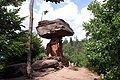
| Siebengebirge Nature Park | North Rhine-Westphalia |
1959 | 48 | The park includes the Siebengebirge Siebengebirge The Siebengebirge is a German range of hills to the East of the Rhine, southeast of Bonn, consisting of more than 40 mountains and hills. It is located in the municipalities of Bad Honnef and Königswinter. It is of volcanic origin and came into being between 28 and 15 million years ago... and it is the only nature park in Germany that is designated in its entirety as a nature preserve. The region is characterized by a unique rocky landscape of volcanic origin, showing the results of erosion of volcanic rock Volcanic rock Volcanic rock is a rock formed from magma erupted from a volcano. In other words, it is an igneous rock of volcanic origin... s and exposure of intrusive Intrusion An intrusion is liquid rock that forms under Earth's surface. Magma from under the surface is slowly pushed up from deep within the earth into any cracks or spaces it can find, sometimes pushing existing country rock out of the way, a process that can take millions of years. As the rock slowly... rocks. |
|
| Solling-Vogler Nature Park Solling-Vogler Nature Park The Solling-Vogler Nature Park is a nature park in South Lower Saxony in Germany. It has an area of and was established in 1966.The nature park includes the hill ranges of the Solling and the Vogler but also the Burgberg which lies east of Weser valley between the two upland regions... |
Lower Saxony |
1966 | 527 | The park includes both the low mountain ranges Solling Solling The Solling is a range of hills up to high in the Weser Uplands in the German state of Lower Saxony, whose extreme southerly foothills extend into Hesse and North Rhine-Westphalia.... and Vogler and the mountain ridge of the Burgberge that lies between them. On the west it borders on the Weser falley Upper Weser Valley The Upper Weser Valley in central Germany has been formed by the Upper Weser river cutting through the Weser Uplands for around between the towns of Hann. Münden and Minden. It lies in the German federal states of Lower Saxony, Hesse and North Rhine-Westphalia.- Course :The Upper Weser Valley... . The park is characterized by narrow crests, steep slopes, deeply incised valleys and large forested areas. |
 |
| Soonwald-Nahe | Rhineland-Palatinate |
2005 | 736 | The park features a diverse landscape in a small area. It comprises the Hunsrück Hunsrück The Hunsrück is a low mountain range in Rhineland-Palatinate, Germany. It is bounded by the river valleys of the Moselle , the Nahe , and the Rhine . The Hunsrück is continued by the Taunus mountains on the eastern side of the Rhine. In the north behind the Moselle it is continued by the Eifel... plateaus, the quartzite Quartzite Quartzite is a hard metamorphic rock which was originally sandstone. Sandstone is converted into quartzite through heating and pressure usually related to tectonic compression within orogenic belts. Pure quartzite is usually white to gray, though quartzites often occur in various shades of pink... crests of the Soonwald showing deeply incised streams and the Nahe River valley. The region is characterized by extensive deciduous forests. |
 |
| Southern Black Forest Nature Park | Baden-Württemberg |
1999 | 3330 | Two thirds of the park is covered by forest and deeply incised by valleys of the Black Forest. In the west and south it comes close to the Rhine, in the east to the Swabian Alb - Wutach Wutach River The Wutach is a river in Baden-Württemberg, Germany. It is formed in the southern part of the Black Forest by the confluence of two smaller rivers, the Haslach and the Gutach, near the town of Lenzkirch.... area and in the north to the Middle Black Forest. |
|
| Stechlin-Ruppiner Land Nature Park Stechlin-Ruppiner Land Nature Park Stechlin-Ruppiner Land Nature Park is a nature park and reserve in the state of Brandenburg, Germany. It covers an area of 1,080 km². It was established on July 1, 2001. It includes Lake Stechlin, home to the endemic Stechlin cisco.... |
Brandenburg |
2001 | 683 | The park is up to 62 percent forested, and borders the Naturpark Uckermärkische Seen. The region is characterized by long chain of lakes, some of them with very clear water, a rare feature in Middle Europe. The large beech forests are ecologically important. | |
| Steigerwald Nature Park Steigerwald Nature Park On 8 March 1988 the Bavarian State Ministry for State Development and the Environment designated an area of in North Bavaria, Germany, as the Steigerwald Nature Park . About half the area consists of protected landscapes... |
Kingdom of Bavaria |
1971 | 1280 | The park is characterized by a gentle low mountain landscape, covered with beech and partly with bright oak groves. The northern border is formed by a big loop of the Main and the southern limit by the river Aisch Aisch The Aisch is a nearly 68 km long tributary of the Regnitz in Middle- and Upper Franconia, in the state of Bavaria in southern Germany.... . |
|
| Steinhuder Meer Nature Park Steinhuder Meer Nature Park The Steinhuder Meer Nature Park , with northwest Germany's largest inland lake, the Steinhuder Meer, at its heart, covers an area of within the districts of Nienburg and Schaumburg and the region of Hanover... |
Lower Saxony |
1974 | 310 | The park includes the largest inland lake in northwestern Germany, the Steinhuder Meer, and is mostly bare of trees. The region is characterized by moorland, which takes up roughly a quarter of the park. The region was formed as a huge glacial ice-parallel meltwater channel (Urstromtal) during the Wolstonian Stage. | 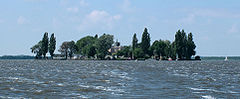 |
| Steinwald Steinwald The Steinwald is a mountain range up to in southern Germany and, at the same time, a nature park founded in 1970 with an area of in the province of Upper Palatinate, in North Bavaria.- Geographical location :... |
Kingdom of Bavaria |
1970 | 246 | The park includes the Steinwald Steinwald The Steinwald is a mountain range up to in southern Germany and, at the same time, a nature park founded in 1970 with an area of in the province of Upper Palatinate, in North Bavaria.- Geographical location :... and is embedded between Fichtelgebirge Fichtelgebirge The Fichtelgebirge is a mountain range in northeastern Bavaria, Germany. It extends from the valley of the Red Main River to the Czech border, a few foothills spilling over into the Czech Republic. It continues in a northeastern direction as the Ore Mountains, and in a southeastern direction as... and Upper Palatinate Forest. It shows a multitude of different landscapes. The western portion is characterized by a landscape of basalt domes with stone run Stone run A stone run is a conspicuous rock landform, result of the erosion of particular rock varieties caused by myriad freezing-thawing cycles taking place in periglacial conditions during the last Ice Age.The actual formation of stone runs involved no less than five processes: weathering, solifluction,... s and bizarre rock formations resembling castles. |
|
| Sternberger Seenland | Mecklenburg-Western Pomerania |
2005 | 540 | The park includes the middle Warnow Warnow The Warnow is a river in the state of Mecklenburg-Vorpommern in Germany. It flows into the Baltic Sea near the town of Rostock, in its borough Warnemünde.... valley and the Sternberg lakes. The region is characterized by forested sandur plains, meltwater channels (Urstromtal) of Warnow and Mildenitz Mildenitz (river) Mildenitz is a river of Mecklenburg-Vorpommern, Germany.-See also:*List of rivers of Mecklenburg-Vorpommern... rivers and meltwater lakes and terminal moraines. |
|
| Stromberg-Heuchelberg Nature Park | Baden-Württemberg |
1980 | 328 | The park includes the Stromberg hills and the Heuchelberg mountain ridge. It is characterized by a well wooded hilly landscape. Geologically, it belongs to the Keuper Keuper The Keuper is a lithostratigraphic unit in the subsurface of large parts of west and central Europe. The Keuper consists of dolostone, shales or claystones and evaporites that were deposited during the Middle and Late Triassic epochs... mountains. The north slopes are mostly forested, the south slopes are used by viticulture. |
|
| Südheide Nature Park Südheide Nature Park The Südheide Nature Park is a large protected area of forest and heathland in the southern part of the Lüneburg Heath in North Germany... |
Lower Saxony |
1963 | 500 | The park lies in the southern Lüneburg Heath and is characterized by large forest and heath areas. The landscape dates from the ice age and is characterized by undulating to gentle hilly terrain and large contiguous forested area. |  |
| Szczecin Lagoon | Mecklenburg-Western Pomerania |
2005 | 537 | The park extends south from lagoon Lagoon A lagoon is a body of shallow sea water or brackish water separated from the sea by some form of barrier. The EU's habitat directive defines lagoons as "expanses of shallow coastal salt water, of varying salinity or water volume, wholly or partially separated from the sea by sand banks or shingle,... s by the Baltic Sea Baltic Sea The Baltic Sea is a brackish mediterranean sea located in Northern Europe, from 53°N to 66°N latitude and from 20°E to 26°E longitude. It is bounded by the Scandinavian Peninsula, the mainland of Europe, and the Danish islands. It drains into the Kattegat by way of the Øresund, the Great Belt and... to the mountains of the Brohmer Berge, and is characterized by the partly flat and partly hilly terminal moraine Terminal moraine A terminal moraine, also called end moraine, is a moraine that forms at the end of the glacier called the snout.Terminal moraines mark the maximum advance of the glacier. An end moraine is at the present boundary of the glacier.... landscape, a coast with lagoon Lagoon A lagoon is a body of shallow sea water or brackish water separated from the sea by some form of barrier. The EU's habitat directive defines lagoons as "expanses of shallow coastal salt water, of varying salinity or water volume, wholly or partially separated from the sea by sand banks or shingle,... s. It comprises vast and contiguous forests of Ueckermünder Heide Ueckermünder Heide Ueckermünder Heide is a 1.000 km² large area of forest and heath in North Eastern Germany at the Oder river and the Szczecin Lagoon. Since 1945, the eastern part belongs to Poland, called Puszcza Wkrzańska... . |
|
| TERRA.vita Nature Park TERRA.vita Nature Park The TERRA.vita Nature Park is located in the German states of Lower Saxony and North Rhine-Westphalia and is divided into northern and southern areas... |
North Rhine-Westphalia Lower Saxony |
1962 | 1140 | The park includes parts of the Teutoburg Forest Teutoburg Forest The Teutoburg Forest is a range of low, forested mountains in the German states of Lower Saxony and North Rhine-Westphalia which used to be believed to be the scene of a decisive battle in AD 9... , the Wiehen Hills and the Weser hills. The park is characterized by a rich and varied low mountain landscape, crossed by many valleys. |
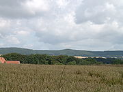 |
| Thuringian Highlands/ Upper Saale |
Thuringia |
1990 | 873 | The park is characterized by deeply incised valleys, above all the Saale Saale The Saale, also known as the Saxon Saale and Thuringian Saale , is a river in Germany and a left-bank tributary of the Elbe. It is not to be confused with the smaller Franconian Saale, a right-bank tributary of the Main, or the Saale in Lower Saxony, a tributary of the Leine.-Course:The Saale... , which winds through its valleys among the mountain ridges. The undulating plateaus are partly covered with dense spruce forests. |
|
| Thuringian Forest Nature Park Thuringian Forest Nature Park The Thuringian Forest Nature Park is one of the two nature parks in Thuringia.The 1990 founded park has a size of 2082 km². It extents around the Rennsteig and comprises almost the entire Thuringian Forest and the Thuringian Highlands with Eisenach in northwest and Sonneberg in the south... |
Thuringia |
1990 | 2082 | The Nature Park compices almost the entire Thuringian Forest Thuringian Forest The Thuringian Forest running northwest to southeast, forms a continuous stretch of ancient rounded mountains posing ample difficulties in transit routing save through a few navigable passes in the southern reaches of the German state of Thuringia. It is about long and wide... and the Thuringian Highland Thuringian Highland The Thuringian Highland or Thuringian Highlands is a low range of mountains in the German state of Thuringia.- Geography :The Thuringian Highland borders on the Thuringian Forest to the southwest... . The region is mostly forested and characterized by deeply incised valleys. The Rennsteig Rennsteig The Rennsteig is a ridge walk as well as an historical boundary path in the Thuringian Forest, Thuringian Highland and Franconian Forest in central Germany.... wends its walkway along the crest. |
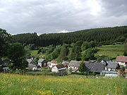 |
| Uckermark Lakes Nature Park Uckermark Lakes Nature Park Uckermark Lakes Nature Park is a nature park and reserve in the state of Brandenburg, Germany. It covers an area of 895 km² . It was established on May 3 1997 and is located on the northern edge of Brandenburg state.... |
Brandenburg |
1997 | 897 | The landscape of the park was shaped in the ice age; it is more than half forested. Terminal moraine hills and lakes alternate in a small area. Apart from rubble, the ice of the Wolstonian stage left sandur plain with many moors and small elongated lakes in glacial valleys. | |
| Upper Bavarian Forest Bavarian Forest thumb|The village of Zell in the Bavarian ForestThe Bavarian Forest is a wooded low-mountain region in Bavaria, Germany. It extends along the Czech border and is continued on the Czech side by the Šumava . Geographically the Bavarian Forest and Bohemian Forest are sections of the same mountain range... |
Kingdom of Bavaria |
1965 | 1738 | The park includes the northwestern Bavarian Forest Bavarian Forest thumb|The village of Zell in the Bavarian ForestThe Bavarian Forest is a wooded low-mountain region in Bavaria, Germany. It extends along the Czech border and is continued on the Czech side by the Šumava . Geographically the Bavarian Forest and Bohemian Forest are sections of the same mountain range... and extends from the crest line to the Falkensteiner Vorwald. The landscape is characterized by wide and gently rolling mountain ridges with their valleys and villages. |
|
| Upper Danube Nature Park | Baden-Württemberg |
1980 | 857 | The park includes the highest areas of the Swabian Jura between Lake Constance Lake Constance Lake Constance is a lake on the Rhine at the northern foot of the Alps, and consists of three bodies of water: the Obersee , the Untersee , and a connecting stretch of the Rhine, called the Seerhein.The lake is situated in Germany, Switzerland and Austria near the Alps... and the Black Forest Black Forest The Black Forest is a wooded mountain range in Baden-Württemberg, southwestern Germany. It is bordered by the Rhine valley to the west and south. The highest peak is the Feldberg with an elevation of 1,493 metres .... . The Jura plateau is covered by extensive woodland and descends gently to the south. The region's thick limestone Limestone Limestone is a sedimentary rock composed largely of the minerals calcite and aragonite, which are different crystal forms of calcium carbonate . Many limestones are composed from skeletal fragments of marine organisms such as coral or foraminifera.... layers are cut by the deeply incised Danube Danube The Danube is a river in the Central Europe and the Europe's second longest river after the Volga. It is classified as an international waterway.... . |
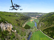 |
| Upper Palatinate Forest | Kingdom of Bavaria |
1971 | 724 | The park is nearly half forested and characterized by a vast undulating to hilly landscape with many small rivers and brooks. Essentially it includes the Upper and Lower Upper Palatinate Forest. | 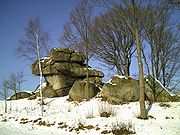 |
| Usedom Usedom Usedom is a Baltic Sea island on the border between Germany and Poland. It is situated north of the Szczecin Lagoon estuary of the River Oder in Pomerania... |
Mecklenburg-Western Pomerania |
1999 | 632 | The park includes the island of Usedom Usedom Usedom is a Baltic Sea island on the border between Germany and Poland. It is situated north of the Szczecin Lagoon estuary of the River Oder in Pomerania... , the water between Usedom and the mainland, and a small strip of mainland. Roughly 30 percent of the region is forested. The park has a great variety of landscaoe forms in a small area. |
|
| Weser Uplands-Schaumburg-Hamelin Nature Park Weser Uplands-Schaumburg-Hamelin Nature Park The Weser Uplands-Schaumburg-Hamelin Nature Park lies on the northern edge of the German Central Uplands where it transitions to the North German Plain, about southwest of Hanover. The sponsor of the nature park, which was founded in 1975, is the state of Lower Saxony... |
Lower Saxony |
1975 | 1116 | The park lies in the transition area from the low mountains to the North German plain North German plain The North German Plain or Northern Lowland is one of the major geographical regions of Germany. It is the German part of the North European Plain... and is divided by the River Weser. A gentle slope, covered by large, contiguous forests, alternate with small valleys. |
|
| Westensee Nature Park | Schleswig-Holstein |
1969 | 260 | The park includes domelike hills as well as the Westensee Westensee Westensee is a municipality in the district of Rendsburg-Eckernförde, in Schleswig-Holstein, Germany.The location of Westensee is south of the municipality of Bredenbek or Felde, but north of Emkendorf or Langwedel, and west of Schierensee.... , which dates from the end of the last glacial period and is crossed by Eider River Eider River The Eider is the longest river of the German state of Schleswig-Holstein. The river starts near Bordesholm and reaches the southwestern outskirts of Kiel on the shores of the Baltic Sea, but flows to the west, ending in the North Sea... . The landscape is characterized by gentle hills and valleys, forests, lakes and moors Moorland Moorland or moor is a type of habitat, in the temperate grasslands, savannas, and shrublands biome, found in upland areas, characterised by low-growing vegetation on acidic soils and heavy fog... . |
|
| Westhavelland Nature Park Westhavelland Nature Park Westhavelland Nature Park is a nature park and reserve in the state of Brandenburg, Germany. It covers an area of 1315 km². It was established on June 11, 1998.... |
Brandenburg |
1998 | 1315 | The park includes the largest contiguous wetland Wetland A wetland is an area of land whose soil is saturated with water either permanently or seasonally. Wetlands are categorised by their characteristic vegetation, which is adapted to these unique soil conditions.... in inland Europe and is of international significance. Large portions of the region consist of inland dune Dune In physical geography, a dune is a hill of sand built by wind. Dunes occur in different forms and sizes, formed by interaction with the wind. Most kinds of dunes are longer on the windward side where the sand is pushed up the dune and have a shorter "slip face" in the lee of the wind... s and sandur Sandur A sandur is a glacial outwash plain formed of sediments deposited by meltwater at the terminus of a glacier.- Formation :Sandar are found in glaciated areas, such as Svalbard, Kerguelen Islands, and Iceland... plains. The region is crossed by the river Havel Havel The Havel is a river in north-eastern Germany, flowing through the German states of Mecklenburg-Vorpommern, Brandenburg, Berlin and Saxony-Anhalt. It is a right tributary of the Elbe river and in length... and its tributaries. |
|
| Wildeshausen Geest Nature Park | Lower Saxony |
1984 | 1554 | The park includes the lowlands on both sides of the River Hunte Hunte The Hunte is a 189 km long river in north-western Germany , left tributary of the Weser. It rises in the Wiehengebirge hills. In the Northern German Plain it flows through lake Dümmer. It flows generally northwards through the towns Bad Essen, Diepholz, Wildeshausen and Oldenburg. It flows... . The thinly forested region is characterized by part of the northwest German Geest ridge and quiet river valleys and heath plains. The region gained its current geological configuration during the Wolstonian Stage. |
|
| Zittauer Gebirge Nature Park Zittauer Gebirge Nature Park Zittau Mountains Nature Park is a nature park in Germany, created in 2008. It lies near to borders of Poland and Czech Republic. It covers an area of of forests, lakes, meadows and peatlands.-Protected areas:... |
Kingdom of Saxony |
2007 | 133 | The park includes the Zittau Hills Zittau Hills The Zittau Mountains , formerly also called the Lusatian Ridge refers to the German part of the Lusatian Mountains that straddle the Saxon-Bohemian border in the extreme southeast of the German state of Saxony.- Location :The Zittau Mountains lie in the extreme south of the district of Görlitz in... (the German side of the Lusatian Mountains Lusatian Mountains The Lusatian Mountains are a mountain range of the Western Sudetes, located on the southeastern border of Germany with the Czech Republic east of the Elbe river, a continuation of the Ore Mountains range west of the Elbe valley... ), and lies in the tripoint Tripoint A tripoint, or trijunction , is a geographical point at which the borders of three countries or subnational entities meet.... with Poland Poland Poland , officially the Republic of Poland , is a country in Central Europe bordered by Germany to the west; the Czech Republic and Slovakia to the south; Ukraine, Belarus and Lithuania to the east; and the Baltic Sea and Kaliningrad Oblast, a Russian exclave, to the north... and the Czech Republic Czech Republic The Czech Republic is a landlocked country in Central Europe. The country is bordered by Poland to the northeast, Slovakia to the east, Austria to the south, and Germany to the west and northwest.... . This smallest of German low mountain ranges (Mittelgebirge) is characterized by variously shaped mountains of sandstone, rock formations, volcanic peaks and incised valleys. |
Literature
- Karl-Heinz Bochow, Klaus Bötig, et al.: Der große ADAC-Freizeitführer – Die letzten Paradiese – Unsere schönsten Natur- und Nationalparks in Deutschland. ADAC Verlag GmbH, München und Verlag Das Beste GmbH, Stuttgart, 1995. ISBN 3-87003-661-3.