

Cuesta
Encyclopedia
Structural geology
Structural geology is the study of the three-dimensional distribution of rock units with respect to their deformational histories. The primary goal of structural geology is to use measurements of present-day rock geometries to uncover information about the history of deformation in the rocks, and...
and geomorphology
Geomorphology
Geomorphology is the scientific study of landforms and the processes that shape them...
, a cuesta (from Spanish
Spanish language
Spanish , also known as Castilian , is a Romance language in the Ibero-Romance group that evolved from several languages and dialects in central-northern Iberia around the 9th century and gradually spread with the expansion of the Kingdom of Castile into central and southern Iberia during the...
: "slope") is a ridge
Ridge
A ridge is a geological feature consisting of a chain of mountains or hills that form a continuous elevated crest for some distance. Ridges are usually termed hills or mountains as well, depending on size. There are several main types of ridges:...
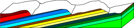
formed by gently tilted sedimentary rock
Sedimentary rock
Sedimentary rock are types of rock that are formed by the deposition of material at the Earth's surface and within bodies of water. Sedimentation is the collective name for processes that cause mineral and/or organic particles to settle and accumulate or minerals to precipitate from a solution....
strata
Stratum
In geology and related fields, a stratum is a layer of sedimentary rock or soil with internally consistent characteristics that distinguish it from other layers...
in a homoclinal structure. Cuestas have a steep slope, where the rock layers are exposed on their edges, called an escarpment
Escarpment
An escarpment is a steep slope or long cliff that occurs from erosion or faulting and separates two relatively level areas of differing elevations.-Description and variants:...
or, if more steep, a cliff
Cliff
In geography and geology, a cliff is a significant vertical, or near vertical, rock exposure. Cliffs are formed as erosion landforms due to the processes of erosion and weathering that produce them. Cliffs are common on coasts, in mountainous areas, escarpments and along rivers. Cliffs are usually...
. Usually an erosion
Erosion
Erosion is when materials are removed from the surface and changed into something else. It only works by hydraulic actions and transport of solids in the natural environment, and leads to the deposition of these materials elsewhere...
-resistant rock layer also has a more gentle slope on the other side of the ridge called a dip slope
Dip slope
A dip slope is a geological formation often created by erosion of tilted strata. Dip slopes are found on homoclinal ridges with one side that is steep and irregular and another side, the dip slope, that is generally planar with a dip parallel to the bedding...
. Because the slope of a homoclinal ridge dips in the same direction as the sedimentary strata, the dip angle of this bedding (Ө) can be calculated by v/h= tan(Ө) where v is equal to the vertical distance and h is equal to the horizontal distance perpendicular to the strike of the beds.
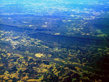
Examples of cuestas
Two well-known cuestas in western New York and southern OntarioOntario
Ontario is a province of Canada, located in east-central Canada. It is Canada's most populous province and second largest in total area. It is home to the nation's most populous city, Toronto, and the nation's capital, Ottawa....
are the Onondaga escarpment and the Niagara escarpment
Niagara Escarpment
The Niagara Escarpment is a long escarpment, or cuesta, in the United States and Canada that runs westward from New York State, through Ontario, Michigan, Wisconsin and Illinois...
, respectively. The dip
Strike and dip
Strike and dip refer to the orientation or attitude of a geologic feature. The strike line of a bed, fault, or other planar feature is a line representing the intersection of that feature with a horizontal plane. On a geologic map, this is represented with a short straight line segment oriented...
of the Onondaga is about 40 feet per mile (about 7.6 m/km) to the south. The escarpment edge faces north and, in its most populated section, runs roughly parallel to the southern Lake Ontario
Lake Ontario
Lake Ontario is one of the five Great Lakes of North America. It is bounded on the north and southwest by the Canadian province of Ontario, and on the south by the American state of New York. Ontario, Canada's most populous province, was named for the lake. In the Wyandot language, ontarío means...
shoreline.
The Gulf Coastal Plain
Gulf Coastal Plain
The Gulf Coastal Plain extends around the Gulf of Mexico in the Southern United States and eastern Mexico.The plain reaches from the western Florida Panhandle, the southwestern two thirds of Alabama, over most of Mississippi, some of western Tennessee and Kentucky, southwest Arkansas, the Florida...
in Texas
Texas
Texas is the second largest U.S. state by both area and population, and the largest state by area in the contiguous United States.The name, based on the Caddo word "Tejas" meaning "friends" or "allies", was applied by the Spanish to the Caddo themselves and to the region of their settlement in...
is punctuated by a series of cuestas that parallel the coast, as are most coastal plains. The Reynosa Plateau is the most coast-ward cuesta, which sees surface expression with the Bordes-Oakville escarpment, on the northwest side and a low ridge on the eastern boundary, called the Reynosa cuesta, where the deposits dip below later Pliocene
Pliocene
The Pliocene Epoch is the period in the geologic timescale that extends from 5.332 million to 2.588 million years before present. It is the second and youngest epoch of the Neogene Period in the Cenozoic Era. The Pliocene follows the Miocene Epoch and is followed by the Pleistocene Epoch...
-Pleistocene
Pleistocene
The Pleistocene is the epoch from 2,588,000 to 11,700 years BP that spans the world's recent period of repeated glaciations. The name pleistocene is derived from the Greek and ....
deposits of the Willis and Lissie Formation.
Cuestas have less dramatic expression in the United Kingdom, with two notable examples being the northwest-facing escarpment of the Jurassic
Jurassic
The Jurassic is a geologic period and system that extends from about Mya to Mya, that is, from the end of the Triassic to the beginning of the Cretaceous. The Jurassic constitutes the middle period of the Mesozoic era, also known as the age of reptiles. The start of the period is marked by...
chalk
Chalk
Chalk is a soft, white, porous sedimentary rock, a form of limestone composed of the mineral calcite. Calcite is calcium carbonate or CaCO3. It forms under reasonably deep marine conditions from the gradual accumulation of minute calcite plates shed from micro-organisms called coccolithophores....
White Horse Hills and the similarly-aligned escarpment of the Cotswolds
Cotswolds
The Cotswolds are a range of hills in west-central England, sometimes called the Heart of England, an area across and long. The area has been designated as the Cotswold Area of Outstanding Natural Beauty...
, sometimes called the Cotswold Edge.
In continental Europe, the Swabian Alb
Swabian Alb
The Swabian Alps or Swabian Jura is a low mountain range in Baden-Württemberg, Germany, extending 220 km from southwest to northeast and 40 to 70 km in width. It is named after the region of Swabia....
offers particularly good views of cuestas in Jurassic
Jurassic
The Jurassic is a geologic period and system that extends from about Mya to Mya, that is, from the end of the Triassic to the beginning of the Cretaceous. The Jurassic constitutes the middle period of the Mesozoic era, also known as the age of reptiles. The start of the period is marked by...
rock. In France
France
The French Republic , The French Republic , The French Republic , (commonly known as France , is a unitary semi-presidential republic in Western Europe with several overseas territories and islands located on other continents and in the Indian, Pacific, and Atlantic oceans. Metropolitan France...
, the term for a cuesta is the same as for a coastline: "côte". Notable French cuestas are the wine-growing regions of Côte d'Or
Côte d'Or (escarpment)
The Côte d'Or is a limestone escarpment in Burgundy, France that lends its name to the department which was formed around it...
and Côtes du Rhône.
See also
- EscarpmentEscarpmentAn escarpment is a steep slope or long cliff that occurs from erosion or faulting and separates two relatively level areas of differing elevations.-Description and variants:...
- Dip slopeDip slopeA dip slope is a geological formation often created by erosion of tilted strata. Dip slopes are found on homoclinal ridges with one side that is steep and irregular and another side, the dip slope, that is generally planar with a dip parallel to the bedding...
- Strike and dipStrike and dipStrike and dip refer to the orientation or attitude of a geologic feature. The strike line of a bed, fault, or other planar feature is a line representing the intersection of that feature with a horizontal plane. On a geologic map, this is represented with a short straight line segment oriented...
- HogbackHogback (geology)A hogback is a homoclinal ridge, formed from a monocline, composed of steeply tilted strata of rock protruding from the surrounding area. The name comes from the ridge resembling the high, knobby spine between the shoulders of a hog. In most cases, the two strata that compose a hogback are...