

High Fens
Encyclopedia
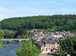
The High Fens which were declared a nature reserve in 1957, are an upland area, a plateau region in the province of Liège
, in the east of Belgium
and nearby parts of Germany
, lying between the Ardennes
and the Eifel
highlands. It is the largest nature reserve or park in Belgium, with an area of 4501.2 hectares (11,122.7 acre); it lies within the German-Belgian natural park Hohes Venn-Eifel
(700 square kilometre), in the Ardennes
. Its highest point, at 694 metres (2,276.9 ft) above sea level, is the Signal de Botrange
near Eupen
, which is also the highest point in Belgium. A 6 metres (19.7 ft) tower was built here that rises to 700 metres (2,296.6 ft). The reserve is ecologically a rich endowment of Belgium covered with alpine sphagnum
bogs both on the plateau and in valley basin; the bogs, which are over 10,000 years old, with their unique subalpine flora, fauna and microclimate, are key to the conservation work of the park.
In 1966, the European Council
awarded the "Diploma of Conservation" to the High Fens, for their ecological value.
and forest
. The provincial capital of Liège is to its west, the German border is to the east and the Ardennes dark forested hills encompass the southern part. The park stretches between Eupen
in the north, Monschau
in the east, Spa
in the west and Malmedy
in the south. It stretches north of Melmedy up as afar as Eupen and marks the end of the Ardennes proper. It is contiguous with the Eifel hills, which stretch east from the German border to form the large Deutsch–Belgischer Naturpark
. Signal de Botrange located in the Haute Fagnes is marked by a Telecom Tower erected over an older artificial, earthen mound with stone steps that was built to raise a small part of the broad plateau from 694–700 m (2,276.9–2,296.6 ft). Large urban centres in the vicinity of the reserve are Eupen, Verviers, Spa and Malmedy.
Part of the High Fens reserve remains closed during the spring because of the breeding season of the endangered black grouse
(Tetrao tetrix). During the summer season there is risk of fire in the forest area. Boardwalks cover the bogs permitting access across these areas. Paths cover many areas in the park and there are sign posts to guide visitors through the park. The nature reserve of the High Fens is coordinated under the Nature Division and Forests of the Walloon Region.
The annual maximum and minimum rainfall recorded are 2024 millimetres (79.7 in) and 762 millimetres (30 in) respectively, with maximum intensity of 156 millimetres (6.1 in) on 7 October 1982 at the Signal de Botrange. The maximum snowfall recorded at Signal de Botrange was 115 centimetres (45.3 in) in 1953. The maximum number of frost days (when temperate remains below 0 °C (32 °F) is reported to be 158 days and the minimum is 70 days. The lowest temperature recorded was -23.6 C in 1942, it was -25.2 C in 1952 at Baraque-Michel.
 Several rivers have their source in the High Fens: the Vesdre
, Hoëgne
, Warche
, Gileppe
, Eau Rouge
, Amblève
, Our, Kyll
, and Rur
. In winter all the water sources freeze into snow making the High Fens one of the best ski resorts in Belgium. During winter the swamps appear as if "wrapped in white fluffy snow shawl".
, breeds here. Zone D is a totally protected reserve area, without access to the public.
The High Venn's plateau thus is rich in flora and fauna some of which have become rare and threatened in the last more than three centuries. The heather
s and turf moors in the reserve have a significant role to maintain biodiversity for the rare and threatened flora and fauna as it ensures regulation of the water balance and maintains value of the landscape. However, since the 17th century, peat cutting, drainage, inappropriate spruce
plantations, infestation of the ground by the purple moor-grass, a herb, had caused problems for the ecology of the region. These negative aspects are now being rectified by special projects titled "Life-Nature Project".
in the family Ericaceae
is a shrub found at an altitude of 500 m; the rootless peat mosses (Sphagnum
) of about 40 centimetres (15.7 in) growing at 3 centimetres (1.2 in) a year form the basic turf moors with buildup of organic matter; cotton grass, a perennial plant in wet regions; sundew
(Drosera rotundfolia) found in the acid turfs of the reserve which are carnivores and consumes insects; and wintergreen chickweed
(cerastium
}, which is a seven-petal flower and also the logo of the park.
 Faunal species recorded are: wild boars, roe deer
, Lyre birds, hen harrier
, black grouse
(Tetrao tetrix), Mulot sylvestre, wood mouse deer, deer (Capreolus capreolus), Grasshopper Warbler
(Locustella naevia), Northern Shrike (Lanius excubitor), Meadow pipit
(Anthus pratensis), Stonechat (Saxicola
) (torquata) and Wheatear Oenanthe (Oenanthe
). The black grouse, a protected species, is found in small numbers. It is a sedentary bird. The male species has black plumage with a red wattle above the eyes while the female species has a brown plumage with black, grey and white stripes and possesses a light forked tail. Vertebrates, spiders and insects reported in the reserve are: orvet (Anguis fragilis
), Odonata Orthoptera, Heteroptera Lepidoptera, diptera
, crustaceans, myriapods and shellfish
.
, bicycling and trekking. Cross-country skiing in the High Fens is permitted on specified forest tracks which are located in the outskirts or even outside the nature reserve. Hiking trails have been reorganized outside the parks reserved areas. The walk routes would be limited to undergrowth adjacent to nature reserve. Bicycle routes have been specified outside the nature reserve in nearby forests. The Subalpine climate may change to subarctic condition and hence when taking adventure walks in the night through the park it could be hazardous unless one is properly equipped for taking such a risk.
, erected in High Fens at Gèyeté within the municipal boundary of Sart
and Jalhay
is in memory of eight American airmen who were the crew of 3 c-47 that collided in flight on 6 April 1945 due to fog and killed them. The memorial consists of a three-bladed propeller erected on a quartzite
pedestal, with a cross erected next to it with the inscription "For the American airmen."
Liège (province)
Liège is the easternmost province of Belgium and belongs to the Walloon Region. It is an area of French and German ethnicity. It borders on the Netherlands, Germany, Luxembourg, and in Belgium the provinces of Luxembourg, Namur, Walloon Brabant , and those of Flemish Brabant and Limburg . Its...
, in the east of Belgium
Belgium
Belgium , officially the Kingdom of Belgium, is a federal state in Western Europe. It is a founding member of the European Union and hosts the EU's headquarters, and those of several other major international organisations such as NATO.Belgium is also a member of, or affiliated to, many...
and nearby parts of Germany
Germany
Germany , officially the Federal Republic of Germany , is a federal parliamentary republic in Europe. The country consists of 16 states while the capital and largest city is Berlin. Germany covers an area of 357,021 km2 and has a largely temperate seasonal climate...
, lying between the Ardennes
Ardennes
The Ardennes is a region of extensive forests, rolling hills and ridges formed within the Givetian Ardennes mountain range, primarily in Belgium and Luxembourg, but stretching into France , and geologically into the Eifel...
and the Eifel
Eifel
The Eifel is a low mountain range in western Germany and eastern Belgium. It occupies parts of southwestern North Rhine-Westphalia, northwestern Rhineland-Palatinate and the south of the German-speaking Community of Belgium....
highlands. It is the largest nature reserve or park in Belgium, with an area of 4501.2 hectares (11,122.7 acre); it lies within the German-Belgian natural park Hohes Venn-Eifel
Hohes Venn – Eifel Nature Park
The German-Belgian Hohes Venn – Eifel Nature Park , often called the North Eifel Nature Park , is a cross-border nature park with elements in the German federal states of North Rhine-Westphalia and Rhineland-Palatinate as well as the Belgian province of Liège...
(700 square kilometre), in the Ardennes
Ardennes
The Ardennes is a region of extensive forests, rolling hills and ridges formed within the Givetian Ardennes mountain range, primarily in Belgium and Luxembourg, but stretching into France , and geologically into the Eifel...
. Its highest point, at 694 metres (2,276.9 ft) above sea level, is the Signal de Botrange
Signal de Botrange
The Signal de Botrange is the highest point in Belgium, located in the High Fens , at . It is the top of a broad plateau, and a road crosses the summit, passing an adjacent café. In 1923, the six-metre-high Baltia tower was built on the summit to allow visitors to reach an altitude of 700 m...
near Eupen
Eupen
Eupen is a municipality in the Belgian province of Liège, from the German border , from the Dutch border and from the "High Fens" nature reserve...
, which is also the highest point in Belgium. A 6 metres (19.7 ft) tower was built here that rises to 700 metres (2,296.6 ft). The reserve is ecologically a rich endowment of Belgium covered with alpine sphagnum
Sphagnum
Sphagnum is a genus of between 151 and 350 species of mosses commonly called peat moss, due to its prevalence in peat bogs and mires. A distinction is made between sphagnum moss, the live moss growing on top of a peat bog on one hand, and sphagnum peat moss or sphagnum peat on the other, the...
bogs both on the plateau and in valley basin; the bogs, which are over 10,000 years old, with their unique subalpine flora, fauna and microclimate, are key to the conservation work of the park.
In 1966, the European Council
European Council
The European Council is an institution of the European Union. It comprises the heads of state or government of the EU member states, along with the President of the European Commission and the President of the European Council, currently Herman Van Rompuy...
awarded the "Diploma of Conservation" to the High Fens, for their ecological value.
Geography
The High Fens, established as a reserve in 1957, with their high relief and unique location, consist mainly of moorland, peat bogs, and low, grass- or wood- covered hills, moorlandMoorland
Moorland or moor is a type of habitat, in the temperate grasslands, savannas, and shrublands biome, found in upland areas, characterised by low-growing vegetation on acidic soils and heavy fog...
and forest
Forest
A forest, also referred to as a wood or the woods, is an area with a high density of trees. As with cities, depending where you are in the world, what is considered a forest may vary significantly in size and have various classification according to how and what of the forest is composed...
. The provincial capital of Liège is to its west, the German border is to the east and the Ardennes dark forested hills encompass the southern part. The park stretches between Eupen
Eupen
Eupen is a municipality in the Belgian province of Liège, from the German border , from the Dutch border and from the "High Fens" nature reserve...
in the north, Monschau
Monschau
Monschau is a small resort town in the Eifel region of western Germany, located in the district Aachen, North Rhine-Westphalia.-Geography:The town is located in the hills of the North Eifel, within the Hohes Venn – Eifel Nature Park in the narrow valley of the Rur river.The historic town center...
in the east, Spa
Spa, Belgium
Spa is a municipality of Belgium. It lies in the country's Walloon Region and Province of Liège. It is situated in a valley in the Ardennes mountain chain, some southeast of Liège, and southwest of Aachen. As of 1 January 2006, Spa had a total population of 10,543...
in the west and Malmedy
Malmedy
Malmedy is a municipality of Belgium. It lies in the country's Walloon Region, Province of Liège. It belongs to the French Community of Belgium, within which it is French-speaking with facilities for German-speakers. On January 1, 2006 Malmedy had a total population of 11,829...
in the south. It stretches north of Melmedy up as afar as Eupen and marks the end of the Ardennes proper. It is contiguous with the Eifel hills, which stretch east from the German border to form the large Deutsch–Belgischer Naturpark
Hohes Venn – Eifel Nature Park
The German-Belgian Hohes Venn – Eifel Nature Park , often called the North Eifel Nature Park , is a cross-border nature park with elements in the German federal states of North Rhine-Westphalia and Rhineland-Palatinate as well as the Belgian province of Liège...
. Signal de Botrange located in the Haute Fagnes is marked by a Telecom Tower erected over an older artificial, earthen mound with stone steps that was built to raise a small part of the broad plateau from 694–700 m (2,276.9–2,296.6 ft). Large urban centres in the vicinity of the reserve are Eupen, Verviers, Spa and Malmedy.
Part of the High Fens reserve remains closed during the spring because of the breeding season of the endangered black grouse
Black Grouse
The Black Grouse or Blackgame is a large bird in the grouse family. It is a sedentary species, breeding across northern Eurasia in moorland and bog areas near to woodland, mostly boreal...
(Tetrao tetrix). During the summer season there is risk of fire in the forest area. Boardwalks cover the bogs permitting access across these areas. Paths cover many areas in the park and there are sign posts to guide visitors through the park. The nature reserve of the High Fens is coordinated under the Nature Division and Forests of the Walloon Region.
Climate
The reserve's climate, unlike other Belgian regions, is one of the wettest and coldest part of Belgium. It is frequently shrouded in mist and low clouds with a high level of rainfall. It experiences subalpine climate with strong winds and a fierce winter, which could turn subarctic. The plateau Fagnes obstructs the clouds from the prevailing Atlantic winds, which results in copious precipitation, an average of 1400 millimetres (55.1 in) of rain per year. However, below the fragile composition of the overlying soils, the basement is formed of rocky beds and clay that prevent infiltration of water and thus create conditions for wetlands, marshes and bogs.The annual maximum and minimum rainfall recorded are 2024 millimetres (79.7 in) and 762 millimetres (30 in) respectively, with maximum intensity of 156 millimetres (6.1 in) on 7 October 1982 at the Signal de Botrange. The maximum snowfall recorded at Signal de Botrange was 115 centimetres (45.3 in) in 1953. The maximum number of frost days (when temperate remains below 0 °C (32 °F) is reported to be 158 days and the minimum is 70 days. The lowest temperature recorded was -23.6 C in 1942, it was -25.2 C in 1952 at Baraque-Michel.
Vesdre
thumb|right|250px|The course of the VesdreThe Weser or Vesdre is a river in eastern Belgium, in the province of Liège, and is a right tributary to the river Ourthe. Its source lies in the High Fens , close to the border with Germany near Monschau...
, Hoëgne
Hoëgne
The Hoëgne is a river in Belgium, a left tributary of the Vesdre. Its source is in the High Fens of eastern Belgium, near the Signal de Botrange. The Hoëgne flows through Theux, and ends in the Vesdre in Pepinster....
, Warche
Warche
The Warche is a river in eastern Belgium .From its source at Losheimergraben on the Belgian-German border, it flows roughly west about 50 km, across the south of the Hautes Fagnes region....
, Gileppe
Gileppe
The Gileppe is a river in Belgium with a length of about 20 km. It is a left tributary of the Vesdre. Its source is in the High Fens of eastern Belgium. The Gileppe flows through an artificial lake , built in 1867-1878 and enlarged to 1.3 square kilometres in 1968-1971, creaed by the Gileppe Dam...
, Eau Rouge
Eau Rouge
The Eau Rouge is a small, 15 km long stream in the Belgian province of Liège, right tributary of the Amblève. It starts in the Hautes Fagnes and ends in Challes, near Stavelot in the river Amblève....
, Amblève
Amblève (river)
The Amblève or Amel is a 93 km long river in eastern Belgium in the province of Liège. It is a right tributary of the river Ourthe. It rises near Büllingen in the High Fens , close to the border with Germany.Tributaries of the Amblève are the rivers Warche, Eau Rouge, Salm and Lienne...
, Our, Kyll
Kyll
The Kyll , noted by the Roman poet Ausonius as Celbis, is a 142km long river in western Germany , left tributary of the Moselle. It rises in the Eifel mountains, near the border with Belgium and flows generally south through the towns Stadtkyll, Gerolstein, Kyllburg and east of Bitburg...
, and Rur
Rur
The Rur , — not to be confused with the Ruhr — is a river which flows through portions of Belgium, Germany and the Netherlands. It is a right tributary to the river Meuse...
. In winter all the water sources freeze into snow making the High Fens one of the best ski resorts in Belgium. During winter the swamps appear as if "wrapped in white fluffy snow shawl".
Zoning
The region has been zoned under a regulation of 1992 into specific zones, keeping in view the access areas provided for visitors and tourists. The areas are defined under three zones namely, Zones B, C, and D. Zone B, which is open daily to the public entails observing of specific civic rules: bicycles and dogs are forbidden in the Zone; identified tracks are not to be transgressed; waste is to be disposed only in trashcans; and silence is to be maintained. Zone C can be visited only accompanied by an authorised guide of the park administration. However, from mid-March to late June access to this zone of the reserve is also closed, when an endangered species, the black grouseBlack Grouse
The Black Grouse or Blackgame is a large bird in the grouse family. It is a sedentary species, breeding across northern Eurasia in moorland and bog areas near to woodland, mostly boreal...
, breeds here. Zone D is a totally protected reserve area, without access to the public.
Flora and fauna
In the High Fens the habitats of many plants and animals typically found further north or in the mountains, result from the geology and relief, the harsh climate, high rainfall, long and cold winters and low average temperatures in the region.The High Venn's plateau thus is rich in flora and fauna some of which have become rare and threatened in the last more than three centuries. The heather
Erica
Erica ,the heaths or heathers, is a genus of approximately 860 species of flowering plants in the family Ericaceae. The English common names "heath" and "heather" are shared by some closely related genera of similar appearance....
s and turf moors in the reserve have a significant role to maintain biodiversity for the rare and threatened flora and fauna as it ensures regulation of the water balance and maintains value of the landscape. However, since the 17th century, peat cutting, drainage, inappropriate spruce
Spruce
A spruce is a tree of the genus Picea , a genus of about 35 species of coniferous evergreen trees in the Family Pinaceae, found in the northern temperate and boreal regions of the earth. Spruces are large trees, from tall when mature, and can be distinguished by their whorled branches and conical...
plantations, infestation of the ground by the purple moor-grass, a herb, had caused problems for the ecology of the region. These negative aspects are now being rectified by special projects titled "Life-Nature Project".
Flora
The Common Heather or Calluna, a small bush of 20–50 cm (7.9–19.7 in) height is food source for the sheep grazing and also possess healing qualities; the bilberryBilberry
Bilberry is any of several species of low-growing shrubs in the genus Vaccinium , bearing edible berries. The species most often referred to is Vaccinium myrtillus L., but there are several other closely related species....
in the family Ericaceae
Ericaceae
The Ericaceae, commonly known as the heath or heather family, is a group of mostly calcifuge flowering plants. The family is large, with roughly 4000 species spread across 126 genera, making it the 14th most speciose family of flowering plants...
is a shrub found at an altitude of 500 m; the rootless peat mosses (Sphagnum
Sphagnum
Sphagnum is a genus of between 151 and 350 species of mosses commonly called peat moss, due to its prevalence in peat bogs and mires. A distinction is made between sphagnum moss, the live moss growing on top of a peat bog on one hand, and sphagnum peat moss or sphagnum peat on the other, the...
) of about 40 centimetres (15.7 in) growing at 3 centimetres (1.2 in) a year form the basic turf moors with buildup of organic matter; cotton grass, a perennial plant in wet regions; sundew
Sundew
Drosera, commonly known as the sundews, comprise one of the largest genera of carnivorous plants, with at least 194 species. These members of the family Droseraceae lure, capture, and digest insects using stalked mucilaginous glands covering their leaf surface. The insects are used to supplement...
(Drosera rotundfolia) found in the acid turfs of the reserve which are carnivores and consumes insects; and wintergreen chickweed
Chickweed
Chickweed, a common name, can refer to:* Cerastium - Mouse-ear Chickweed* Holosteum - Jagged Chickweed* Moenchia - Upright Chickweed* Paronychia - Chickweed* Stellaria pro parte - Chickweed...
(cerastium
Cerastium
Cerastium is a genus of annual, winter annual, or perennial plants belonging to the family Caryophyllaceae. The around 100 species are commonly called Mouse-ear chickweed; different species are found nearly worldwide but the greatest concentration is mainly from the northern temperate areas of the...
}, which is a seven-petal flower and also the logo of the park.
Fauna
Roe Deer
The European Roe Deer , also known as the Western Roe Deer, chevreuil or just Roe Deer, is a Eurasian species of deer. It is relatively small, reddish and grey-brown, and well-adapted to cold environments. Roe Deer are widespread in Western Europe, from the Mediterranean to Scandinavia, and from...
, Lyre birds, hen harrier
Hen Harrier
The Hen Harrier or Northern Harrier is a bird of prey. It breeds throughout the northern parts of the northern hemisphere in Canada and the northernmost USA, and in northern Eurasia. This species is polytypic, with two subspecies. Marsh Hawk is a historical name for the American form.It migrates...
, black grouse
Black Grouse
The Black Grouse or Blackgame is a large bird in the grouse family. It is a sedentary species, breeding across northern Eurasia in moorland and bog areas near to woodland, mostly boreal...
(Tetrao tetrix), Mulot sylvestre, wood mouse deer, deer (Capreolus capreolus), Grasshopper Warbler
Grasshopper Warbler
The Grasshopper Warbler, Locustella naevia, is an Old World warbler in the grass warbler genus Locustella. It breeds across much of temperate Europe and Asia. It is migratory, wintering from northwest Africa to India....
(Locustella naevia), Northern Shrike (Lanius excubitor), Meadow pipit
Meadow Pipit
The Meadow Pipit Anthus pratensis, is a small passerine bird which breeds in much of the northern half of Europe and also northwestern Asia, from southeastern Greenland and Iceland east to just east of the Ural Mountains in Russia, and south to central France and Romania; there is also an isolated...
(Anthus pratensis), Stonechat (Saxicola
Saxicola
The genus Saxicola , the stonechats or chats, is a genus of 15 species of small passerine birds restricted to the Old World...
) (torquata) and Wheatear Oenanthe (Oenanthe
Water dropwort
The water dropworts, Oenanthe , are a genus of plants in the family Apiaceae. Most of the species grow in damp ground, in marshes or in water....
). The black grouse, a protected species, is found in small numbers. It is a sedentary bird. The male species has black plumage with a red wattle above the eyes while the female species has a brown plumage with black, grey and white stripes and possesses a light forked tail. Vertebrates, spiders and insects reported in the reserve are: orvet (Anguis fragilis
Anguis fragilis
Anguis fragilis, or slow worm, slow-worm or slowworm, is a limbless reptile native to Eurasia. It is also sometimes referred to as the blindworm or blind worm, though the Royal Society for the Protection of Birds considers this to be incorrect.Slow worms are semi-fossorial lizards spending much...
), Odonata Orthoptera, Heteroptera Lepidoptera, diptera
Diptera
Diptera , or true flies, is the order of insects possessing only a single pair of wings on the mesothorax; the metathorax bears a pair of drumstick like structures called the halteres, the remnants of the hind wings. It is a large order, containing an estimated 240,000 species, although under half...
, crustaceans, myriapods and shellfish
Shellfish
Shellfish is a culinary and fisheries term for exoskeleton-bearing aquatic invertebrates used as food, including various species of molluscs, crustaceans, and echinoderms. Although most kinds of shellfish are harvested from saltwater environments, some kinds are found only in freshwater...
.
Fires
As the habitat consists of bogs, fire is a major hazard during the drought period, when Fens is closed except for a small fen area near Poleur. Triangular signs painted in red are fixed at the fire hazard locations. In April 2011, in a fire that broke out in the High Fens, 1000 hectares (2,471.1 acre) of land were destroyed. Stated to be the biggest ever fire in the Fens, 300 fire fighters supported by a helicopter were involved in dousing and controlling the fires.Activities
The winter sports activities allowed in the Fens in specified area and outside conserved area of the fens are skiingSkiing
Skiing is a recreational activity using skis as equipment for traveling over snow. Skis are used in conjunction with boots that connect to the ski with use of a binding....
, bicycling and trekking. Cross-country skiing in the High Fens is permitted on specified forest tracks which are located in the outskirts or even outside the nature reserve. Hiking trails have been reorganized outside the parks reserved areas. The walk routes would be limited to undergrowth adjacent to nature reserve. Bicycle routes have been specified outside the nature reserve in nearby forests. The Subalpine climate may change to subarctic condition and hence when taking adventure walks in the night through the park it could be hazardous unless one is properly equipped for taking such a risk.
Monument
Another notable monument, apart from the 6 metres (19.7 ft) tower built over the Signal de BotrangeSignal de Botrange
The Signal de Botrange is the highest point in Belgium, located in the High Fens , at . It is the top of a broad plateau, and a road crosses the summit, passing an adjacent café. In 1923, the six-metre-high Baltia tower was built on the summit to allow visitors to reach an altitude of 700 m...
, erected in High Fens at Gèyeté within the municipal boundary of Sart
Sart
Sart is a name for the settled inhabitants of Central Asia which has had shifting meanings over the centuries. Sarts, known sometimes as Ak-Sart in ancient times, did not have any particular ethnic identification, and were usually town-dwellers.-Origin:There are several theories about the origin...
and Jalhay
Jalhay
Jalhay is a municipality of Belgium. It lies in the country's Walloon Region and Province of Liege. On January 1, 2006 Jalhay had a total population of 7,953. The total area is 107.75 km² which gives a population density of 74 inhabitants per km². The highest point of the municipality is the...
is in memory of eight American airmen who were the crew of 3 c-47 that collided in flight on 6 April 1945 due to fog and killed them. The memorial consists of a three-bladed propeller erected on a quartzite
Quartzite
Quartzite is a hard metamorphic rock which was originally sandstone. Sandstone is converted into quartzite through heating and pressure usually related to tectonic compression within orogenic belts. Pure quartzite is usually white to gray, though quartzites often occur in various shades of pink...
pedestal, with a cross erected next to it with the inscription "For the American airmen."