
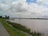
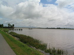
Eider River
Encyclopedia
Germany
Germany , officially the Federal Republic of Germany , is a federal parliamentary republic in Europe. The country consists of 16 states while the capital and largest city is Berlin. Germany covers an area of 357,021 km2 and has a largely temperate seasonal climate...
state
States of Germany
Germany is made up of sixteen which are partly sovereign constituent states of the Federal Republic of Germany. Land literally translates as "country", and constitutionally speaking, they are constituent countries...
of Schleswig-Holstein
Schleswig-Holstein
Schleswig-Holstein is the northernmost of the sixteen states of Germany, comprising most of the historical duchy of Holstein and the southern part of the former Duchy of Schleswig...
. The river starts near Bordesholm
Bordesholm
Bordesholm is a town in Schleswig-Holstein, Germany in the district Rendsburg-Eckernförde. Bordesholm is also the name of a former historical district of the Kingdom of Prussia and Weimar Republic for which it was the district capital...
and reaches the southwestern outskirts of Kiel
Kiel
Kiel is the capital and most populous city in the northern German state of Schleswig-Holstein, with a population of 238,049 .Kiel is approximately north of Hamburg. Due to its geographic location in the north of Germany, the southeast of the Jutland peninsula, and the southwestern shore of the...
on the shores of the Baltic Sea
Baltic Sea
The Baltic Sea is a brackish mediterranean sea located in Northern Europe, from 53°N to 66°N latitude and from 20°E to 26°E longitude. It is bounded by the Scandinavian Peninsula, the mainland of Europe, and the Danish islands. It drains into the Kattegat by way of the Øresund, the Great Belt and...
, but flows to the west, ending in the North Sea
North Sea
In the southwest, beyond the Straits of Dover, the North Sea becomes the English Channel connecting to the Atlantic Ocean. In the east, it connects to the Baltic Sea via the Skagerrak and Kattegat, narrow straits that separate Denmark from Norway and Sweden respectively...
. The middle part of the Eider was appropriated for use as part of the Kiel Canal
Kiel Canal
The Kiel Canal , known as the Kaiser-Wilhelm-Kanal until 1948, is a long canal in the German state of Schleswig-Holstein.The canal links the North Sea at Brunsbüttel to the Baltic Sea at Kiel-Holtenau. An average of is saved by using the Kiel Canal instead of going around the Jutland Peninsula....
.
In the Early Middle Ages
Early Middle Ages
The Early Middle Ages was the period of European history lasting from the 5th century to approximately 1000. The Early Middle Ages followed the decline of the Western Roman Empire and preceded the High Middle Ages...
the river is believed to have been the border between the related Germanic tribes the Jutes
Jutes
The Jutes, Iuti, or Iutæ were a Germanic people who, according to Bede, were one of the three most powerful Germanic peoples of their time, the other two being the Saxons and the Angles...
and the Angles
Angles
The Angles is a modern English term for a Germanic people who took their name from the ancestral cultural region of Angeln, a district located in Schleswig-Holstein, Germany...
who during this period, along with the neighboring Saxons
Old Saxony
Old Saxony is the original homeland of the Saxons in the northwest corner of modern Germany and roughly corresponds today with the contemporary Lower Saxony, Westphalia and western Saxony-Anhalt....
crossed the North Sea
North Sea
In the southwest, beyond the Straits of Dover, the North Sea becomes the English Channel connecting to the Atlantic Ocean. In the east, it connects to the Baltic Sea via the Skagerrak and Kattegat, narrow straits that separate Denmark from Norway and Sweden respectively...
from this region and settled in England. During the High Middle Ages
High Middle Ages
The High Middle Ages was the period of European history around the 11th, 12th, and 13th centuries . The High Middle Ages were preceded by the Early Middle Ages and followed by the Late Middle Ages, which by convention end around 1500....
the Eider was the border between the Saxons and the Danes, as reported by Adam of Bremen
Adam of Bremen
Adam of Bremen was a German medieval chronicler. He lived and worked in the second half of the eleventh century. He is most famous for his chronicle Gesta Hammaburgensis Ecclesiae Pontificum .-Background:Little is known of his life other than hints from his own chronicles...
in 1076. For centuries it divided Denmark
Denmark
Denmark is a Scandinavian country in Northern Europe. The countries of Denmark and Greenland, as well as the Faroe Islands, constitute the Kingdom of Denmark . It is the southernmost of the Nordic countries, southwest of Sweden and south of Norway, and bordered to the south by Germany. Denmark...
and the Holy Roman Empire
Holy Roman Empire
The Holy Roman Empire was a realm that existed from 962 to 1806 in Central Europe.It was ruled by the Holy Roman Emperor. Its character changed during the Middle Ages and the Early Modern period, when the power of the emperor gradually weakened in favour of the princes...
. Today it is the border between Schleswig
Schleswig
Schleswig or South Jutland is a region covering the area about 60 km north and 70 km south of the border between Germany and Denmark; the territory has been divided between the two countries since 1920, with Northern Schleswig in Denmark and Southern Schleswig in Germany...
and Holstein
Holstein
Holstein is the region between the rivers Elbe and Eider. It is part of Schleswig-Holstein, the northernmost state of Germany....
, the northern and southern parts, respectively, of the modern German state of Schleswig-Holstein.
The Eider flows through the following towns: Bordesholm
Bordesholm
Bordesholm is a town in Schleswig-Holstein, Germany in the district Rendsburg-Eckernförde. Bordesholm is also the name of a former historical district of the Kingdom of Prussia and Weimar Republic for which it was the district capital...
, Kiel
Kiel
Kiel is the capital and most populous city in the northern German state of Schleswig-Holstein, with a population of 238,049 .Kiel is approximately north of Hamburg. Due to its geographic location in the north of Germany, the southeast of the Jutland peninsula, and the southwestern shore of the...
, Rendsburg
Rendsburg
Rendsburg is a town on the River Eider and the Kiel Canal in the northeastern part of Schleswig-Holstein, Germany. It is the capital of the Kreis of Rendsburg-Eckernförde. As of 2006, it had a population of 28,476.-History:...
, Friedrichstadt
Friedrichstadt
Friedrichstadt is a town in the district of Nordfriesland, in Schleswig-Holstein, Germany. It is situated on the river Eider approx. 12 km south of Husum. It was founded in 1621 by Dutch settlers...
and Tönning
Tönning
Tönning is a town in the district of Nordfriesland in the German state of Schleswig-Holstein. During the Great Northern War, Tönning was besieged twice.-Geography:...
. Near Tönning it flows into the North Sea. The estuary
Estuary
An estuary is a partly enclosed coastal body of water with one or more rivers or streams flowing into it, and with a free connection to the open sea....
has tidal flats
Mudflat
Mudflats or mud flats, also known as tidal flats, are coastal wetlands that form when mud is deposited by tides or rivers. They are found in sheltered areas such as bays, bayous, lagoons, and estuaries. Mudflats may be viewed geologically as exposed layers of bay mud, resulting from deposition of...
and brackish water
Brackish water
Brackish water is water that has more salinity than fresh water, but not as much as seawater. It may result from mixing of seawater with fresh water, as in estuaries, or it may occur in brackish fossil aquifers. The word comes from the Middle Dutch root "brak," meaning "salty"...
. The mouth of the river is crossed by a closeable storm surge barrier
Flood barrier
A flood barrier, surge barrier of storm surge barrier is a specific type of floodgate, designed to prevent a storm surge or spring tide from flooding the protected area behind the barrier...
, the Eider Barrage
Eider Barrage
The Eider Barrage is located at the mouth of the river Eider near Tönning on Germany’s North Sea coast. Its main purpose is protection from storm surges by the North Seas. It is Germany’s largest coastal protection structure...
.
Navigation
A tidal lockLock (water transport)
A lock is a device for raising and lowering boats between stretches of water of different levels on river and canal waterways. The distinguishing feature of a lock is a fixed chamber in which the water level can be varied; whereas in a caisson lock, a boat lift, or on a canal inclined plane, it is...
provides access for boats through the Eider Barrage
Eider Barrage
The Eider Barrage is located at the mouth of the river Eider near Tönning on Germany’s North Sea coast. Its main purpose is protection from storm surges by the North Seas. It is Germany’s largest coastal protection structure...
. The fishing port of Tönning
Tönning
Tönning is a town in the district of Nordfriesland in the German state of Schleswig-Holstein. During the Great Northern War, Tönning was besieged twice.-Geography:...
lies 11 kilometres (6.8 mi) upstream of the barrier, whilst Friedrichstadt
Friedrichstadt
Friedrichstadt is a town in the district of Nordfriesland, in Schleswig-Holstein, Germany. It is situated on the river Eider approx. 12 km south of Husum. It was founded in 1621 by Dutch settlers...
is 15 kilometres (9.3 mi) further upstream. At Friedrichstadt a lock gives access to the River Treene.
The Eider remains tidal as far as the lock at Nordfeld, 6 kilometres (3.7 mi) above Friedrichstadt. There is a further lock at Lexfähre, 52 kilometres (32.3 mi) upstream of Nordfeld. A further 3 kilometres (1.9 mi) beyond Lexfähre is the junction with the short Gieselau Canal
Gieselau Canal
The Gieselau Canal, or Gieselaukanal in German, is a canal in the German state of Schleswig-Holstein. It is located close to Oldenbüttel and links the Kiel Canal with the River Eider....
, which provides a navigable link to the Kiel Canal
Kiel Canal
The Kiel Canal , known as the Kaiser-Wilhelm-Kanal until 1948, is a long canal in the German state of Schleswig-Holstein.The canal links the North Sea at Brunsbüttel to the Baltic Sea at Kiel-Holtenau. An average of is saved by using the Kiel Canal instead of going around the Jutland Peninsula....
at Oldenbüttel
Oldenbüttel
Oldenbüttel is a municipality in the district of Rendsburg-Eckernförde, in Schleswig-Holstein, Germany....
. The Eider therefore provides an alternative route from the North Sea
North Sea
In the southwest, beyond the Straits of Dover, the North Sea becomes the English Channel connecting to the Atlantic Ocean. In the east, it connects to the Baltic Sea via the Skagerrak and Kattegat, narrow straits that separate Denmark from Norway and Sweden respectively...
to the Kiel Canal, avoiding the tides of the estuary of the Elbe
Elbe
The Elbe is one of the major rivers of Central Europe. It rises in the Krkonoše Mountains of the northwestern Czech Republic before traversing much of Bohemia , then Germany and flowing into the North Sea at Cuxhaven, 110 km northwest of Hamburg...
.
The head of navigation lies a further 23 kilometres (14.3 mi) upstream at Rendsburg
Rendsburg
Rendsburg is a town on the River Eider and the Kiel Canal in the northeastern part of Schleswig-Holstein, Germany. It is the capital of the Kreis of Rendsburg-Eckernförde. As of 2006, it had a population of 28,476.-History:...
. Although it is adjacent to the Kiel Canal, through passage is no longer possible.