

Harz
Encyclopedia
The Harz is the highest mountain range
in northern Germany and its rugged terrain extends across parts of Lower Saxony
, Saxony-Anhalt
and Thuringia
. The name Harz derives from the Middle High German
word Hardt
or Hart (mountain forest), latinized as Hercynia
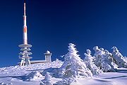
. The legendary Brocken is the highest summit in the Harz with a height of 1141.1 metres (3,743.8 ft) above sea level. The Wurmberg
(971 metres (3,185.7 ft)) is the highest peak located entirely within Lower Saxony.
 The Harz has a length of 110 kilometres (68.4 mi), stretching from the town of Seesen
in the northwest to Eisleben
in the east, and a width of 35 kilometres (21.7 mi). It occupies an area of 2226 sqkm, and is divided into the Upper Harz
(Oberharz) in the northwest, which is up to 800 m high, apart from the 1,100 m high Brocken massif, and the Lower Harz (Unterharz) in the east which is up to around 400 m high and whose plateaus are capable of supporting arable farming.
The following districts (Kreise) fall wholly or partly within the Harz: Goslar and Osterode am Harz in the west, Harz and Mansfeld-Südharz in the north and east, and Nordhausen in the south.The districts of the Upper Harz are Goslar and Osterode (both in Lower Saxony), whilst the Lower Harz is on the territory of Harz and Mansfeld-Südharz districts (both in Saxony-Anhalt). The Upper Harz is generally higher and features fir
forests, whilst the Lower Harz gradually descends into the surrounding area and has deciduous forests interspersed with meadows.
The dividing line between Upper and Lower Harz follows approximately a line from Ilsenburg
to Bad Lauterberg, which roughly separates the catchment areas for the Weser (Upper Harz) and Elbe
(Lower Harz). Only on the southeastern perimeter of the Upper Harz, which is also called the High Harz (Hochharz) (Goslar, Osterode and Harz districts), does the mountain range exceed on the Brocken massif. Its highest peak is the Brocken (1,141 m), its subsidiary peaks are the Heinrichshöhe
(1,044 m) to the southeast and the Königsberg
(1,023 m) to the southwest. Other prominent hills in the Harz are the Acker-Bruchberg
ridge (927 m), the Achtermannshöhe
(925 m) and the Wurmberg
(971 m) near Braunlage
. In the far east, the mountains merge into the East Harz foothills (Harz district, Saxony-Anhalt), which are dominated by the Selke Valley. Part of the south Harz lies in the Thuringian district of Nordhausen.
The Harz National Park
is located in the Harz; the protected area
covers the Brocken and surrounding wilderness area.
Approximately 600,000 people live in towns and villages of the Harz mountains.
 Because of the heavy rainfall in the region the rivers of the Harz Mountains were dammed from an early date. Examples of such masonry dams are the two largest: the Oker Dam
and the Rappbode Dam
. The clear, cool water of the mountain streams was also dammed by early mountain folk to form the various mountain ponds of the Upper Harz waterways, such as the Oderteich
.
The 17 dams in the Harz block a total of twelve rivers. Because the Harz is one of the regions of Germany that experiences the most rainfall, its water power was used from early times. Today the dams are primarily used to generate electricity
, to provide drinking water
, to prevent flooding
and to supply water in times of scarcity. Modern dam-building began in the Harz with the construction of the Söse Valley Dam, that was built between 1928 and 1931. The dams of the Upper Harz lakes are some of the oldest dams in Germany that are still in operation.
→ See List of dams in the Harz
The largest rivers in the Harz are the Innerste
, the Oker
and the Bode in the north; the Wipper in the east; and the Oder
in the south. The Innerste merges into the Leine
and its tributaries are the Nette
and the Grane
. The rivers Radau, Ecker
and Ilse all discharge into the Oker. The Hassel
, the Selke
and the Holtemme
(whose main tributary is the Zillierbach
) flow into the Bode. The Wipper is fed by the Eine
. The Rhume is joined by the Söse
and the Oder; the latter being fed by the Sieber
. The Zorge
, the Wieda
and the Uffe
all flow into the Helme.
→ See List of rock formations (crags, tors, etc.) in the Harz
, although it is overwhelmingly dominated by base-poor rocks. The most common rocks lying on the surface are argillaceous shale
s, slaty (geschieferte) greywacke
s and granite
intrusions in the shape of two large igneous rock masses or plutons. The Gießen-Harz surface layer of the Rhenohercynian zone
, which is widespread in the Harz, consists mainly of flysch
. Well-known and economically important are the limestone
deposits around Elbingerode and the Gabbro
of Bad Harzburg
. The landscapes of the Harz are characterised by steep mountain ridges, stone run
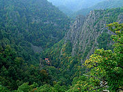
s, relatively flat plateaus with many raised bogs and long, narrow V-shaped valleys, of which the Bode Gorge
, the Oker
and Selke
valleys are the best known. A representative cross-section of all the Harz rocks is displayed on the Jordanshöhe near Sankt Andreasberg
near the car park (see photo).
The formation and geological folding
of the Harz mountains began during a prominent phase of the Palaeozoic era, in the course of the Hercynian mountain building of the Carboniferous period, about 350 to 250 million years ago. At that time in the history of the Earth, numerous high mountains appeared in Western Europe, including the Fichtelgebirge
and Rhenish Massif. They were, however, heavily eroded due to their height (up to 4 km) and were later covered over by Mesozoic
rocks. From the Early Cretaceous
and into Late Cretaceous
times the Harz was uplifted in a single block by tectonic movements and, particularly during the Tertiary
period, the younger overlying strata were eroded and the underlying base rock left standing as low mountains. The most important uplift movements were during the sub-Hercynian phase (83 mya), when the northern edge was steeply tilted. This formed a fault zone on the northern border of the Harz (the Northern Harz Boundary Fault
or Harznordrandverwerfung).
The Harz is a fault-block mountain range, that rises abruptly from the surrounding lowlands in the west and northeast and gradually dips towards the south. It is dissected by numerous deep valleys. North of the mountains lie the Cretaceous layers of the sub-Hercynian depression in the rolling hills of the Harz Foreland; south of the Harz, Permian
sediments lie flat on southwest-dipping Palaeozoic beds.
As a result of the northern fault zone and the vertical or, sometimes even overfolded, geological strata, the geology of the Harz sometimes changes frequently within a relatively small area of just a few square kilometres. As a consequence of this it is also referred to as the "Classic Geological Square Mile" (Klassischen Quadratmeile der Geologie).
There is a room devoted to geology in the Harz Museum in Wernigerode.
→ See Harz granite
:
From the edge of the Harz to 700 m above sea level beech woods dominate, especially the Wood-Rush beech woods on locations poorly supplied with nutrients where the common beech (Fagus sylvatica) is often the only tree species. In lower, drier locations the English oak (Quercus robur) and sessile oak
(Quercus petraea) occur as well. Sycamore trees
(Acer pseudoplatanus) may be found growing in wetter places. During times of decay and rejuvenation when there is plenty of light, light-dependent pioneers such as rowan (Sorbus aucuparia), silver birch
(Betula pendula) and pussy willow
(Salix caprea) play a role. Melic grass
beech woods are found in the few places where there is an abundance of nutrients and bases
, e. g. over dolerite and gneiss
formations, and they have a vegetation layer rich in variety and luxuriant growth. Here, too, the common beech dominates, mixed, for example, with sycamore, ash (Fraxinus excelsior), hornbeam (Carpinus betulus) and Scots elm (Ulmus glabra). As a result of the increasingly continental climate on the eastern edge of the Harz, the common beech gives way to mixed forests of sessile oak.
At intermediate heights of between 700 and 800 m above sea level, mixed woods of spruce
(Picea abies) and common beech would predominantly be found under natural conditions. Apart from a few remnants, these were however supplanted a long time ago by spruce stands as a result of deliberate forest management
. The sycamore also occurs in these woods.
Spruce woods thrive in the highest locations from about 800 m to the tree line at around 1,000 m above sea level. These woods are also home to some deciduous trees such as rowan, silver and downy birch
es (Betula pendula and Betula pubescens) and willow
s (Salix spec.). Conditions of high humidity foster an environment rich in moss
es and lichen
s. In spite of the near-natural habitat there are only a few, indigenous, genetically adapted (autochthone) spruce trees. Wood-reed spruce woods dominate. A well developed ground vegetation thrives on their moderately rocky and fresh, but certainly not wet, soils, characterised in appearance especially by grasses such as shaggy wood-reed
(Calamagrostis villosa) and wavy hair-grass
(Avenella flexuosa). The soils in the higher regions are, as in most of the Harz, comparatively poor in nutrients and bases, so that only a few herbaceous plants occur here, such as heath bedstraw (Galium saxatile). For that reason it is more the ferns, mosses, lichens and fungi that, in addition to spruce trees, characterise these woods. Boulders and stone runs occur in the areas of weather-resistant rock in the high (alti-)montane and montane zones – these are extreme habitats for vegetation. Due to the lack of soil material, only weak, straggly, very open spruce woods thrive here. They have an especially high variety of trees and allow more room of light-loving species such as silver birch, rowan, sycamore, willow and dwarf bushes such as the blueberry
(Vaccinium myrtillus). Mosses and ferns are also common here. One unusual species is the Carpathian birch
(Betula carpatica). Bog-spruce woods are found around the raised bogs on marshy and boggy soils. In these sorts of places spruce woods can, in exceptional cases, also form the natural woodland in lower down the mountains. These wet, moorland woods have a high proportion of peat mosses (Sphagnum spec.). The ground vegetation may also have a rich proliferation of low bushes such as cowberry (Vaccinium vitis-idaea). Clumps of purple moor grass (Molinia caerulea) are also typical of this type of woodland habitat. The characteristic species of fungi in natural spruce woods are Phellinus viticola
and prunes and custard
(Tricholomopsis decora).
Ravine (Schluchtwald), riparian (Auwald) and river source (Quellwald) woods only occur in small areas. In these places the common beech gives way to hardier deciduous species such as sycamore, large-leaved lime (Tilia platyphyllos), Scots elm or ash. The herbaceous layer is similar to that of the better-nourished beech woods. Notable species amongst the plant communities here include the Alpine blue-sow-thistle
(Cicerbita alpina), perennial honesty
(Lunaria rediviva), hard shield fern
(Polystichum aculeatum) and long beech fern
(Phegopteris connectilis).
about 10,000 years ago. A significant proportion of the vegetation on these raised bogs is made up of peat mosses (Sphagnum spec.). The wetter areas (Schlenken) and the higher-lying, drier areas (Bulten) are home to different species of flora. In the Schlenken, for example, Sphagnum cuspidatum is found, whereas the Bulten are preferred by Sphagnum magellanicum. The blanket of peat moss is penetrated by dwarf bushes such as cowberry and blueberry
. Bog-rosemary
(Andromeda polifolia) is a relict of the ice age. Other such ice age plants include the dwarf birch
(Betula nana) and few-flowered sedge (Carex pauciflora). Cranberries (Vaccinium oxicoccus) bloom from May to June. The black crowberry (Empetrum nigrum) may also be seen amongst those bearing black fruit. Common heather (Calluna vulgaris) grows on the drier Bulten and occasionally the cross-leaved heath (Erica tetralix) may be found. Typical grasses are the sheathed cottongrass (Eriophorum vaginatum), known for its bright, white clusters of fruit and deergrass
(Scirpus cespitosus), which is rust-red in the autumn. One fascinating moorland plant is the round-leaved sundew (Drosera rotundifolia). Bog or northern bilberry (Vaccinium uliginosum) grows on the drier bog perimeters.
 A multitude of wild animals live in the beech forests of the Harz mountains. Over 5,000 species, most of them insects, have their home in these woods. They include many species that help to decompose leaves and work them into the soil and ground cover, including springtail
s, oribatid mites
, woodlice, roundworms, millipede
s, earthworm
s and snail
s. Characteristic breeding birds in the beech woods, with their abundance of dead wood, are the black woodpecker
(Dryocopus martius) and stock dove (Columba oenas). An indication of the natural state of the beech woods in the Harz is the return of the black stork
(Ciconia nigra). This shy and susceptible resident of richly diverse deciduous and mixed forest has become very rare in central Europe due to increasing disturbance of its habitat (caused by a lack of old trees and natural brooks). Through improvements to its habitat, including the renaturalisation of waterways and the creation of relatively undisturbed peaceful areas, the black stork population has now recovered. A typical mammal of such deciduous woods is the wild cat
(Felis felis), that has established a stable population in the Harz. It prefers the diverse wooded areas, which offer a rich variety of food.
The animal kingdom of the mixed beech and spruce woods is also diverse. Species that thrive in mixed forest are especially at home. For example, the mixed mountain forest is the natural habitat of the capercaillie
(Tetrao urogallus). The Tengmalm's owl
(Aegolius funereus) may also be found here. It breeds almost exclusively in black woodpecker
holes in old beeches, and needs, unlike the spruce woods, more open beech forest with its higher population of small mammals in its search for food. For cover, however, it prefers the darker, denser spruce trees.
A large number of the animals that live in natural spruce forest are suited to the special conditions of life in the higher parts of the Harz. Typical residents amongst the bird population include the crested tit
(Parus cristatus), goldcrest
and Firecrest (Regulus regulus und Regulus ignicapillus), siskin
(Carduelis spinus),
treecreeper (Certhia familiaris), coal tit
(Parus ater) and crossbill
(Loxia curvirostra). Special mention should be made here of the pygmy owl (Glaucidium passerinum) which is threatened with extinction and which lives in the submontane to subalpine zones within mixed and pine forests interspersed with open areas. They prefer spruce woods for breeding, but feed in more open stands of trees or on open moorland. Like the black stork
, the pygmy owl had long since disappeared from the Harz, but returned in the 1980s of its own volition, as its ancestral homeland once again became more natural, so that there was sufficient food to support it (insects, small mammals and small birds) as well as standing dead wood (spruce trees with woodpecker holes).
In addition to the many species of birds, there is a range of large butterflies in the various spruce woods that, outside of the Harz, are seriously endangered or simply non-existent. Two species will be mentioned here as examples. Gnophos sordarius occurs in old, open wood-reed spruce forest, sometimes in connection with stone runs or bog spruce forests; Enthephria caesiata is a native of the bilberry-rich bog spruce woods.
Only a few animals are able to survive the extreme conditions of the raised bogs. Examples of these are the Alpine emerald dragonfly (Somatochlora alpestris), which only occurs in Lower Saxony in the Harz, and is endangered in Germany, and the Subarctic darner
(Aeshna subarctica), a damselfly
which is threatened with extinction.
Rocks and stone run
s are important habitat components for the peregrine falcon
(Falco peregrinus) and ring ouzel
(Turdus torquatus). The peregrine, which is threatened with extinction here, needs steep rock outcrops with little vegetation. After its population had died out in the Harz, a breeding pair was re-established in the region. A crucial contribution has been made by extensive efforts to promote quiet areas in the ancestral breeding grounds of this shy species. Since 1980, a breeding pair has settled in the eastern Harz as the result of a wildlife reintroduction project. The ring ouzel prefers semi-open stone runs and lightly wooded transition zones between treeless raised bogs and forest
s. The Harz is home to one of its few, isolated breeding areas in central Europe. Its main distribution area extends across northwest Europe, including large parts of England and Scotland, as well as the high mountains of southern and eastern Europe.
The waterways, with their distinct mountain stream character, play an important role right across the Harz. In comparison with the other natural regions of Lower Saxony, they are still very natural and varied, and the water is very clean. As a result of the high water velocity of the Harz streams, flowers rarely gain a foothold in the water. Even the animals in these streams need to be well suited to high velocities. Only a few species, such as fish, swim actively against the stream. The most common species are brown trout
(Salmon trutta forma fario) and bullhead
(Cottus gobio). Much richer in variety, by contrast, is the range of species in the system of crevices under the streambed. In addition to the insects and fish hatchlings that thrive here, may be found protozoons, flatworms (Turbellaria
) and water mites (Hygrobatoidea). Other species of animals cling fast to the stones, e. g. caddis fly larvae (Trichoptera) and snails, or can only live in the reduced water velocities on the bed of the stream or on stones by having flat body shapes, e. g. stonefly larvae. In the calmer parts of the stream, behind stones or in blankets of moss, there are also water beetle
s (Hydrophilidae) and small shrimp-like amphipods.
Occasionally the golden-ringed dragonfly (Cordulegaster boltoni) and Beautiful Demoiselle
(Calopteryx virgo), a type of damselfly
, can be seen by streams in the Harz.
The dipper
(Cinclus cinclus), which is found everywhere on Harz streams, occurs almost exclusively in the highlands. Its habitat is very fast-flowing, clear mountain streams with wooded banks. It can dive and run under water along the stream bed. It turns stones over in its search for food. The grey wagtail
(Motacilla cinerea) also uses the rich food supplies of the mountain brooks.
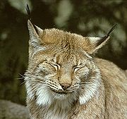
In 2000, the lynx
was successfully reintroduced by the Harz National Park
, and it has since fitted well into the ecology of the region. Through specific conservation measures in past years, the retreat of the bat population in the Harz has been halted. Amongst the mammals that may be hunted are the red deer
, roe deer
, wild boar and mouflon
.
King Louis the Pious
. Settlement within the mountains began only 1000 years ago, as in ancient times dense forests made the region almost inaccessible. The suffix -rode (from , to stub) denotes a place where woodland had been cleared to develop a settlement.
The year 968 saw the discovery of silver
deposits near the town of Goslar
, and mine
s became established in the following centuries throughout the mountains. During the Middle Ages
, ore from this region was exported along trade routes to far-flung places, such as Mesopotamia
. The wealth of the region declined after these mines became exhausted in the early 19th century. People abandoned the towns for a short time, but prosperity eventually returned with tourism. Between 1945 and 1990, the inner German border ran through the Harz, the west belonging to the Federal Republic of Germany
(West Germany) and the east to the German Democratic Republic
(East Germany). Today the Harz forms a popular tourist destination for summer hiking as well as winter sports.
hunted in and around the Harz near Bilzingsleben
(Thuringia), Hildesheim
and Schöningen
(Lower Saxony). The Neanderthal
s entered the stage about 250,000 years ago and hunted aurochs
, bison
, brown bear
and cave bear
, mammoth
s, rhinos
, horses, reindeer
, forest elephants and other animals in the Harz region. Tools used by Neanderthals were discovered inter alia in the Einhorn Cave in the southern Harz (100,000 years ago) and in the Rübeland Caves. Finds of birch pitch near Aschersleben on the northern edge of the Harz point to the use of this prehistoric adhesive
by Neanderthals about 50,000 years ago. The Upper Palaeolithic Revolution, about 40,000 years ago, saw Homo sapiens move from Africa into Europe, including to the Harz region, where they appear to have ousted the Neanderthals and subsequently settled here.
Many discoveries in the Harz, such as the bronze club of Thale, which was found by the Roßtrappe
, could indicate an earlier Celtic occupation of the Harz.
itself was first mentioned in a deed by the Emperor, Louis the Pious
, from the year 814, in which it was referred to by its High German form, Hartingowe. According to the Fulda
annals of 852, the Harzgau was occupied by the Harudes
and after whom the Harudengau (Harudorum pagus) was named. Harud, from which Hard, Hart and Harz are derived, means forest or forested mountains, and the Harudes were the residents or dwellers in the Harud.
Of more recent origin are settlements whose names end in –rode, a suffix that is first discernable in the Harzgau from the mid-9th century. Where the founders of these villages came from is unknown.
Charlemagne
declared the Harz a restricted imperial forest or Reichsbannwald. The Saxon Mirror (Sachsenspiegel
), the oldest German law book (Rechtsbuch), probably published around 1220/30 at Falkenstein Castle in the Selke valley, later made the imperial restriction clear: "Whoever rides through the Harz Forest, must unstring his bow and crossbow and keep dogs on a line – only crowned royalty (gekrönte Häupter) are allowed to hunt here". Eike von Repkow's Sachsenspiegel which, for centuries, formed the basis on which German law was administered, described the Harz as a place where wild animals are guaranteed protection in the king's restricted forests. There were three restricted forests, so described, in the state of Saxony, where there was no longer unfettled access for everyone.
This ban did not last forever. Mining, ironworks, water management, increasing settlement, woodland clearances, cattle driving, agriculture and, later, tourism, all undermined this imperial protection over the centuries.
As early as 1224, monks who had settled in Walkenried bought extensive tracts of forest in the western Harz, to secure economically the one quarter of the Rammelsberg ore profits promised to them by Frederick Barbarossa in 1129. From that it can be deduced that there was already a shortage of wood then. From the 12th to the 14th centuries, large parts of the Harz were managed economically by the Cistercian Abbey of Walkenried
. As well as agriculture and fishing, they also controlled the silver mining indusry in the Upper Harz and in Goslar.
In the middle of the 14th century, the settlements in the Harz became heavily depopulated as a result of the Black Death
, and a systematic resettlement of mining villages in the Upper Harz did not take place until the first half of the 16th century.
In 1668, Rudolph Augustus, Duke of Brunswick-Lüneburg
granted the first conservation order for Baumann's Cave
. The ducal decree stated, inter alia, that the cave should be permanently preserved by all those responsible as a special, natural wonder. It also stated that nothing should be spoiled or destroyed, and that groups of ordinary strangers should not be allowed to enter without prior arrangement. A resident mine worker was entrusted to oversee the natural monument
. Until the issue of this conservation order, there had only been an order for the protection of the forest, which had been issued by the ruling princes for real, practical considerations. But for the first time the 1668 cave order took ethical-aesthetic considerations into account. The year 1668 was the birth of classic nature conservation in the Harz. The order had been precipitated by the earlier, serious destruction of the cave's features by vandals. The first Harz 'rangers' were formed.
In 1705, the last bear was killed in the Harz, on the Brocken.
The steadily increasing consumption of wood by the pits and smelting works led to overexploitation
of the forests and, from about 1700, to their outright destruction. There were no less than 30,000 charcoal piles in the Harz. In 1707, an order by Count Ernst of Stolberg forbade Brocken guides to take strangers or local folk to the Brocken without special permission, and the lighting of fires was forbidden.
The first attempts at forest conservation in the Harz were centred on the Brocken, and began with a far-sighted nature conservation act over 275 years ago. In 1718, Count Christian Ernest of the House of Stolberg
issued an ordinance in which destruction or damage to the forest on the Brocken would be severely punished. In 1736, Christian Ernest also built the Wolkenhäuschen ("Little House in the Clouds") on the Brocken.
As a young man, the famous German poet, Goethe
visited the Harz several times and had a number of important lifetime experiences. These included his walks on the Brocken and his visit to the mines in Rammelsberg. Later, his observations of the rocks on the Brocken led to his geological research. His first visit to the Harz awakened in him a keen interest in science (see Goethes: Wahrheit und Dichtung). In 1777, Goethe climbed the Brocken, departing from Torfhaus.
At that time, there was still no mass tourism on the Brocken; in the year 1779 only 421 walkers were recorded. Goethe described his feelings on the summit later, as follows: So lonely, I say to myself, while looking down at this peak, will it feel to the person, who only wants to open his soul to the oldest, first, deepest feelings of truth.
On 23 March 1798, the last wolf was killed in the Harz near the Plessenburg.
The count's guest house on the Heinrichshöhe had become too small and suffered from overcrowding; in 1799 it burned down. In 1800, a new guest house was built on the Brocken to replace it.
Around 1800, large swathes of the Harz were deforested. The less resistant spruce monoculture, that arose as a consequence of the mining industry in the Upper Harz, was largely destroyed by a bark beetle
outbreak and a storm of hurricane proportions in November 1800. This largest known bark beetle infestation in the Harz was known as the Große Wurmtrocknis, and destroyed about 30000 hectares (74,131.5 acre) of spruce forest and lasted about for 20 years. The woods were largely reforested with spruce. Continuous problems with bark beetle and storms were the negative side effects of mining in the Harz mountains.
In 1818, a mounted forester, Spellerberg, from Lautenthal, killed the last lynx in the Harz on the Teufelsberg.
At the start of the 19th century, the increasing changes to the natural landscape wrought by the man and the extinction of large mammals like the bear, wolf and lynx raised awareness of the threat to nature.
In 1852, the district administrator of Quedlinburg placed the Teufelsmauer
, "a rock outcrop famous as an object of folklore and as a rare natural curiosity", near Thale under protection, because the inhabitants of neighbouring districts were using the rocks as a quarry. This protection order survived in spite of all protests from the local villages. Thus, a valuable natural monument was saved from destruction, and it is of note that the authorities felt that the 'romantic' reasons for its preservation were entirely justified.
Professor Dr. Albert Peter laid out the Brocken Garden in 1890. This was the first Alpine flower garden to be established on German soil. And, in terms of its scientific concept and scope, the Brocken Garden was the first of its type worldwide.
The Brocken Railway was began service in 1899, against the already strong concerns of conservationist
s. For example, the botanist, Bley, wanted to prevent trains from climbing the Brocken, because it he felt it would threaten the Brocken's flora.
In 1907, Hermann Löns uttered his famous cry "More Protection for the Brocken" (Mehr Schutz für den Brocken) in light of the mass tourism that was beginning to affect the Brocken. By 1912, he effectively pressed for the establishment of a Harz National Park, without calling it such, in Der Harzer Heimatspark (Verlag E. Appelhans u. Co., Braunschweig 1912), a brochure that has remained relatively unknown. The Harz played a special role in the life of the famous regional poet, naturalist and local patriot, undoubtedly not least because his second wife, Lisa Hausmann, came from Barbis in the South Harz.
Around 1920, the capercaillie
population in the Harz died out.
The Wernigerode rector, W. Voigt, wrote, in 1926, in his famous Brockenbuch: In America it has long become the business of the people, to create a sacrosanct haven for the native flora and fauna of the regions in national parks. North and South Germany have their heath and alpine parks. May the joint efforts of the royal authorities, the local police, the Wernigerode Nature Conservation Society and individual friends of the Brocken also succeed now in central Germany, through caring nurture across the board, in establishing and preserving the Brocken too, as a small, but unique, nature reserve for the German people.
In the 1930s, national park planning in Germany became specific again. There were concrete plans for the national parks of the Lüneburg Heath, Bavarian - Bohemian Forest, High Tauern, Höllengebirge, Neusiedler See and Kurische Nehrung. The Second World War prevented these national park plans from being taken forward; nevertheless, in 1937, an Upper Harz Nature Reserve (Naturschutzgebietes Oberharz) was designated.
During the Nazi era, the Harz became an important area for the armaments industry. Many factories, important to the war effort, were located here and, as the war neared its conclusion, they were increasingly staffed with forced labour. As a result, the Harz was the location of several hundred forced labour camps and KZs at that time. KZ Dora near Nordhausen in the South Harz became particularly well-known.
In the last weeks of the Second World War, the so-called Harz Fortress (Harzfestung) is worth mentioning. In February/March 1945 the SS Reichsführer, Heinrich Himmler
, established the Harz Fortress to defend central Germany
from the western allies. Its headquarters
was at Blankenburg. Amongst the formations mobilised were divisions belonging to the 11th Army
, divisions of the Waffen SS and the Volkssturm
. When the 1st U.S. Army reached Nordhausen
in the southern Harz, and went to advance northwards, it met with resistance, especially in the hills around the towns of Ilfeld
and Ellrich
. Not until 7 May 1945 did the last formations of the 11th Army and Waffen SS surrender in the mountains of the Harz. Several units of Volkssturm troops fought on against the Americans during May. Seen objectively, the Harz was, however, at the end of the Second World War not a strategic location militarily; the western allies bypassed the Harz relatively effortlessly on their way to Berlin.
.
. The seven Upper Harz mining towns - Clausthal, Zellerfeld, Bad Grund, Sankt Andreasberg
, Lautenthal
, Altenau
and Wildemann
- and around 30 other villages within and on the edge of the Harz can thank the Upper Harz mining
and smelting industries
for their boom. The former imperial town of Goslar
, too, whose splendour depended on the ore treasures of the Rammelsberg, mined argentiferous lead ore for centuries. Mining heavily dominated the economic life of the Harz as well as its scenery. Miners created the famous engineering system for the management of water in the Upper Harz, the Upper Harz Water Regale
, of which 70 kilometres of ditch
and 68 'ponds'
(with a volume of 8 million cubic metres) are still used today. Without using their considerable hydropower
output, silver mining in the Harz would never have been able to attain its major economic significance.
In the eastern Harz Foreland (Mansfelder Land
and Sangerhäuser Mulde) copper
schist was mined until 1990. The early beginnings of this industry were first mentioned in 1199, and it was considered in its heyday, at the end of the 15th century, as the most important in Europe. In addition, at Ilfeld
is the only stone coal mine in the Harz, the former Rabenstein Gallery Mine (Bergwerk Rabensteiner Stollen). In the North Thuringian mining area, there were numerous potash
mines and, in the vicinity of Röblingen, geological waxes were extracted by a mining concern.
The last mine in the Upper Harz – the Wolkenhügel Pit in Bad Lauterberg – closed its operations in June 2007 for economic reasons. Having formerly had 1,000 workers, the mine employed just 14 people towards the end, using the most modern technology to extract barite
. With the closure of this facility, mining operations that had begun in the Middle Ages
and had continued unbroken since the 16th century, extracting silver
, lead
and zinc
, came to an end. Bearing witness to the industry are cultural monuments as well as the negative consequences of mining for the environment such as e. g. pollution of the ecosystem
with heavy metals
.
, iron
, copper
, lead
and zinc
– has declined markedly. However, the heavy metal residues in the soils of the Upper Harz, which in some cases are significant, represent a serious environmental hazard today.
Copper workings are still important today in the area of Mansfeld
. The last centres of mining were the Rammelsberg near Goslar (closed 1988) and the Hilfe Gottes Pit near Bad Grund (closed 1992). In Bad Lauterberg, barite
- used today primarily for the manufacture of paint and in sound insulation - was extracted until July 2007 at the Wolkenhügel Pit, the last mine in the entire Harz. Furthermore, limestone is still mined at Elbingerode in three large open pits (Werk Rübeland
, Werk Kaltes Tal and Werk Hornberg). Another important employer is the Clausthal University of Technology
. In addition to the classical disciplines of mining and metallurgy, many engineering and science subjects, as well as business studies
courses, are taught and researched.
The extensive woods of the Harz mean that forestry
plays an important economic role, as do the associated wood-working industries. In the first millennium AD, hardwood
trees (mainly common beech) were predominant on the higher ground - typical of a natural highland forest. Hence one spoke of going in die Harten ("into the hardwood forest"), a term which gave the Harz its name. Today, however, the commercially managed areas are mainly monoculture
s of Norway spruce
. A cause of this development was the mining history in the Harz region, with its high demand for wood and the consequent overuse and devastation of the stands of forest. In addition, there were the climatic change
s of the so-called Little Ice Age
. The reforestation
with relatively easily managed and undemanding spruce trees since the middle of the 18th century was mainly due to the proposals of the Senior Forester and Master Hunter, Johann Georg von Langen.
is very important to the Harz. There are many spa town
s, and almost every village in the Harz and Harz Foreland caters to tourists. Well-known destinations are the Harz National Park
and the Brocken, as well as the historic towns on the edge of the Harz. Concepts like the Western town, Pullman City Harz, or the rock operas on the Brocken are intended to be particularly attractive to foreign tourists. The Harzer Verkehrsverband (HVV) is responsible for the marketing of the Harz to tourists.
, Ore Mountains, Black Forest
or even the Alps
, there are plenty of winter sport facilities. Of particular note are the villages and towns of Altenau (including Torfhaus
), Benneckenstein
, Braunlage (including Hohegeiß
), Goslar-Hahnenklee
, Hasselfelde
, Sankt Andreasberg (including Sonnenberg
and Oderbrück) and Schierke. Due to the high altitude and length of their runs, Nordic skiing
is very popular. International winter sport competitions take place on the Wurmberg
ski jump near Braunlage and the biathlon
facility at Sonnenberg.
Also worth mentioning are the many cross-country skiing
runs (Loipen) in the Harz. Their quality and features are ensured by the land owners, particularly in the Harz National Park, where snow is still relatively guaranteed during the winter months, and also by individual communities and societies. The Förderverein Loipenverbund Harz, for example, is particularly well known in this regard. It was founded in 1996 on the initiative of the Harz National Park, Harz winter sport parishes, the cable car and lift operators, hotels and transport companies, and has the aim of promoting ski tourism in the Harz and looking after the interests of nature conservation.
The mountain rescue service on the cross-country routes, the toboggan slopes, footpaths, alpine ski pistes and rough terrain is provided by the Bergwacht Harz.
has become increasingly popular.
On several reservoirs in the Harz, a variety of water sports is permitted and, on a number of rivers originating in the Harz, there are opportunities for canoeing
and other sports on white water sections. International canoe and kayak
competitions take place on the Oker below the Oker Dam. The white water on this stretch of river is partly a result of the raised levels of discharge from the Oker Reservoir and so is largely independent of the weather.
Several mountains provide a good base for airborne activities, such as gliding
and hang-gliding, notably the Rammelsberg near Goslar.
The Harz offers a range of climbing areas like, the Oker valley, with its rock outcrops (Klippen); the Adlerklippen being especially popular.
The Harz has also developed in recent years into a very good mountain bike
region, with 62 signed mountain bike routes and four bike parks with lift facilities in Braunlage, Hahnenklee, Schulenberg and Thale. The bike parks offer freeride
, downhill and fourcross
routes. Both the signed cycle paths and the bike parks are suitable for every level of cyclist.
Roads in the Harz are used by racing bikes and touring bikes, despite their sometimes heavy use by lorries, because in the whole of North Germany there is no other region with such long, and in places very steep, routes. In addition, there are a large number of railway connections on the edge of the Harz which allow bicycle
s to be taken on trains.
The Harz Mountain Rescue (Bergwacht Harz) service also operates in summer, rescuing people involved in accidents on difficult terrain.
. In addition, there are several long distance paths (the Harzer Hexenstieg
, Kaiserweg
, Karstwanderweg
and Selketalstieg
), as well as a trans-regional project, the Harzer Wandernadel
, with 222 checkpoints and a range of walking badges that may be earned for various levels of achievement.
By the Oker Valley and Roßtrappe near Thale, there are rocks on the Hohneklippen (the Höllenklippe or the Feuerstein near Schierke, among several) that are used by climbers.
and Thuringian.
A feature of the Upper Harz is, or was, the Upper Harz dialect (Oberharzer Mundart). Unlike the Lower Saxon, Eastphalian and Thuringian dialects of the surrounding region, this was an Ore Mountain dialect
from Saxony and Bohemia, that went back to the settlement of mining folk from that area in the 16th century.
The Upper Harz dialect was used only in a few places. The most well-known are Altenau, Sankt Andreasberg, Clausthal-Zellerfeld, Lautenthal and Hahnenklee. Today the dialect is heard only rarely in the Upper Harz in everyday life and it is mainly members of the older generations that still use it, so occasional articles in the local papers are printed in "Upper Harz" which helps to preserve it.
By way of illustration here is the refrain from a St. Andreasberg folk song:
...which in high German is
... which translates as:
 Geomorphological processes have led to the formation of caves in the gypsum
, dolomite
and limestone
layers of the Harz. These dripstone caves include Baumann's Cave
, the Unicorn Cave
, Hermann's Cave, the Iberg Dripstone Cave
and, on the southern edge of the Harz, the Heimkehle
.
Because the older formations contained many mineral deposits, they were explored very early on by the mining industry. The mines have often been turned into show mines. For example, the Samson Pit
was for a long time the deepest mine in the world. Other show mines are the Büchenberg, Drei Kronen & Ehrt, the Röhrigschacht show mine, the Lange Wand show mine in Ilfeld and the Rabensteiner Stollen show mine in Netzkater.
Others have been turned into mining museums, like the Upper Harz Mining Museum
in Clausthal-Zellerfeld, the Lautenthal
Mining Museum with its pit railway or the Rammelsberg Mining Museum near Goslar, which is a UNESCO
world heritage site. The Roter Bär Pit
in St. Andreasberg also served as a training mine until the 20th century and is today, preserved true to the original, as a visitor mine.
 The following towns and villages are found in or around the Harz region:
, Ilsenburg
, Michaelstein
and Walkenried
are found mainly on the edge of the Harz. In Hahnenklee is a wooden stave church
, the Gustav Adolf Stave Church
which was consecrated in 1908.
or observation tower
s. These include the Carlshaushöhe
near Trautenstein
, the observation tower on the Großer Knollen
or the Josephskreuz.
In historical times, high ridges and spurs were used as sites for fortified castles (Burgen). In the Harz these include Falkenstein Castle
, where Eike von Repkow probably drew up the Sachsenspiegel
, the most important legal code
of the German Middle Ages, Hohnstein Castle near Neustadt/Harz, Lauenburg Castle
near Stecklenberg, Plessenburg
and Stecklenburg
, as well as the ruined castles of Harzburg
, Anhalt
, Königsburg
, Scharzfels
.
In addition to these defensive structures, palatial castles (Schlösser) were also built, such as Herzberg Castle
, Blankenburg Castle
, Stolberg Castle and Wernigerode Castle
.
 The Harz Narrow Gauge Railways, an old fashioned, steam and diesel-powered railway network is a very popular mode of transport, especially with tourists. The railways link Wernigerode
, Nordhausen
, Quedlinburg
and the Brocken. Prior to the closure of the Inner German Border the network was joined at Braunlage
to the South Harz Railway Company.
Main line railways serve the major towns around the Harz including Halberstadt
, Wernigerode, Thale
, Quedlinburg and Nordhausen. The Harz used to be served by a number of branch lines, some of which are still open. Those operating regular passenger services are the Halberstadt–Blankenburg, Quedlinburg–Thale, Klostermansfeld
–Wippra
and Berga
-Kelbra
–Stolberg
lines. All the branch line in Lower Saxony (the Innerste Valley Railway
and Oder Valley Railway
) have been closed. The Rübeland Railway
is only used by goods traffic at present, but there are plans to run it as a heritage railway
.
Around the Harz a number of railway lines form a ring. They are, clockwise from the north, the Heudeber–Danstedt–Vienenburg, the Halberstadt–Vienenburg railway
, the Halle–Halberstadt railway
, the Berlin-Blankenheim Railway, the Halle-Kassel Railway, the South Harz Line, the Herzberg–Seesen railway
, the Goslar–Seesen railway and the Vienenburg–Goslar railway
.
runs along the southwestern perimeter of the Harz via Osterode to Bad Lauterberg. In addition there is a good federal road (the B 6
, B 4
) from Goslar to Braunlage. The North Harz Foreland benefits from the newly-built B 6n
. Both the B 4 and the B 6n have been upgraded almost to motorway standard. The B 4 crosses the Harz from Bad Harzburg on a north-south axis running through Torfhaus and Braunlage as far as Ilfeld on the edge of the South Harz. The rest of the Harz is also well served by federal roads. Important ones include the Harz high road (Harzhochstraße, the B 242
), which crosses the Harz in an east-west direction (from Seesen to Mansfeld) and the B 241
, which runs from Goslar in the north over the Upper Harz (Clausthal-Zellerfeld) as far as Osterode in the south.
Mountain range
A mountain range is a single, large mass consisting of a succession of mountains or narrowly spaced mountain ridges, with or without peaks, closely related in position, direction, formation, and age; a component part of a mountain system or of a mountain chain...
in northern Germany and its rugged terrain extends across parts of Lower Saxony
Lower Saxony
Lower Saxony is a German state situated in north-western Germany and is second in area and fourth in population among the sixteen states of Germany...
, Saxony-Anhalt
Saxony-Anhalt
Saxony-Anhalt is a landlocked state of Germany. Its capital is Magdeburg and it is surrounded by the German states of Lower Saxony, Brandenburg, Saxony, and Thuringia.Saxony-Anhalt covers an area of...
and Thuringia
Thuringia
The Free State of Thuringia is a state of Germany, located in the central part of the country.It has an area of and 2.29 million inhabitants, making it the sixth smallest by area and the fifth smallest by population of Germany's sixteen states....
. The name Harz derives from the Middle High German
Middle High German
Middle High German , abbreviated MHG , is the term used for the period in the history of the German language between 1050 and 1350. It is preceded by Old High German and followed by Early New High German...
word Hardt
Hardt
Hardt may refer to:* Hardt, Westerwaldkreis, a municipality in Rhineland-Palatinate, Germany* Hardt, Baden-Württemberg, a municipality in Baden-Württemberg, Germany* Hardtwald, a forest near Karlsruhe, Germany* Ernst Hardt, a German author...
or Hart (mountain forest), latinized as Hercynia
Rhenohercynian Zone
The Rhenohercynian Zone is in structural geology a fold belt of west and central Europe, formed during the Hercynian orogeny . The zone consists of folded and thrusted Devonian and early Carboniferous sedimentary rocks that were deposited in a back-arc basin along the southern margin of the then...
. The legendary Brocken is the highest summit in the Harz with a height of 1141.1 metres (3,743.8 ft) above sea level. The Wurmberg
Wurmberg (Harz)
At the Wurmberg is the second highest mountain in the Harz and the highest in Lower Saxony .- Geography :The Wurmberg lies north of Braunlage, in the district of Goslar, and west of Schierke. Its summit is located due south of the Brocken and roughly 400 m south of the state border with...
(971 metres (3,185.7 ft)) is the highest peak located entirely within Lower Saxony.
Geography
Location and extent
Seesen
Seesen is a town and municipality in the district of Goslar, in Lower Saxony, Germany. It is situated on the northwestern edge of the Harz mountain range, approx...
in the northwest to Eisleben
Eisleben
Eisleben is a town in Saxony-Anhalt, Germany. It is famous as the hometown of Martin Luther, hence its official name is Lutherstadt Eisleben. As of 2005, Eisleben had a population of 24,552...
in the east, and a width of 35 kilometres (21.7 mi). It occupies an area of 2226 sqkm, and is divided into the Upper Harz
Upper Harz
The Upper Harz refers to the western and higher part of the Harz mountain range in central Germany. Much of the Upper Harz is over , but at its eastern edge in the High Harz it climbs to over on the Brocken massif.- Geography :...
(Oberharz) in the northwest, which is up to 800 m high, apart from the 1,100 m high Brocken massif, and the Lower Harz (Unterharz) in the east which is up to around 400 m high and whose plateaus are capable of supporting arable farming.
The following districts (Kreise) fall wholly or partly within the Harz: Goslar and Osterode am Harz in the west, Harz and Mansfeld-Südharz in the north and east, and Nordhausen in the south.The districts of the Upper Harz are Goslar and Osterode (both in Lower Saxony), whilst the Lower Harz is on the territory of Harz and Mansfeld-Südharz districts (both in Saxony-Anhalt). The Upper Harz is generally higher and features fir
Fir
Firs are a genus of 48–55 species of evergreen conifers in the family Pinaceae. They are found through much of North and Central America, Europe, Asia, and North Africa, occurring in mountains over most of the range...
forests, whilst the Lower Harz gradually descends into the surrounding area and has deciduous forests interspersed with meadows.
The dividing line between Upper and Lower Harz follows approximately a line from Ilsenburg
Ilsenburg
Ilsenburg is a town in the district of Harz, in Saxony-Anhalt in Germany. It is situated under the north foot of the Harz Mountains, at the entrance to the Ilsetal valley of the small Ilse river, a tributary of the Oker, about six north-west of the town of Wernigerode. It received town privileges...
to Bad Lauterberg, which roughly separates the catchment areas for the Weser (Upper Harz) and Elbe
Elbe
The Elbe is one of the major rivers of Central Europe. It rises in the Krkonoše Mountains of the northwestern Czech Republic before traversing much of Bohemia , then Germany and flowing into the North Sea at Cuxhaven, 110 km northwest of Hamburg...
(Lower Harz). Only on the southeastern perimeter of the Upper Harz, which is also called the High Harz (Hochharz) (Goslar, Osterode and Harz districts), does the mountain range exceed on the Brocken massif. Its highest peak is the Brocken (1,141 m), its subsidiary peaks are the Heinrichshöhe
Heinrichshöhe
The Heinrichshöhe is a subsidiary peak of the Brocken and, at , the second highest elevation in the Harz Mountains. The summit lies about 1.4 km southeast of the top of the Brocken near the Brocken Road in the Harz National Park....
(1,044 m) to the southeast and the Königsberg
Königsberg (Brocken)
The Königsberg is a neighbouring peak of the Brocken and, at 1034 m above sea level the third highest elevation in the Harz mountains. It lies on a long ridge that runs from southeast to northwest about 1.5 km south of the Brocken's summit....
(1,023 m) to the southwest. Other prominent hills in the Harz are the Acker-Bruchberg
Bruchberg
At the Bruchberg in the Upper Harz is the second highest mountain in Lower Saxony and the third highest in the Harz mountains in North Germany. It lies between Altenau and Torfhaus in the middle of the Harz National Park. The Bruchberg is more like a plateau and has no real summit...
ridge (927 m), the Achtermannshöhe
Achtermannshöhe
At , the Achtermannshöhe in the Harz National Park is the third highest mountain in Lower Saxony and the fourth highest in the Harz mountains....
(925 m) and the Wurmberg
Wurmberg (Harz)
At the Wurmberg is the second highest mountain in the Harz and the highest in Lower Saxony .- Geography :The Wurmberg lies north of Braunlage, in the district of Goslar, and west of Schierke. Its summit is located due south of the Brocken and roughly 400 m south of the state border with...
(971 m) near Braunlage
Braunlage
Braunlage is a town and health resort in the Goslar district in Lower Saxony in Germany. It lies within the Harz mountain range, south of the Brocken.Nowadays Braunlage's main business is tourism, particularly ski tourists...
. In the far east, the mountains merge into the East Harz foothills (Harz district, Saxony-Anhalt), which are dominated by the Selke Valley. Part of the south Harz lies in the Thuringian district of Nordhausen.
The Harz National Park
Harz National Park
The Harz National Park is a nature reserve in the German federal states of Lower Saxony and Saxony-Anhalt. It comprises large portions of the western Harz mountain range, extending from Herzberg and Bad Lauterberg at the southern edge to Bad Harzburg and Ilsenburg on the northern slopes...
is located in the Harz; the protected area
Protected area
Protected areas are locations which receive protection because of their recognised natural, ecological and/or cultural values. There are several kinds of protected areas, which vary by level of protection depending on the enabling laws of each country or the regulations of the international...
covers the Brocken and surrounding wilderness area.
Approximately 600,000 people live in towns and villages of the Harz mountains.
Rivers and lakes
Oker Dam
The Oker Dam is a dam in the Harz mountains in Lower Saxony, Germany. It is fed by the River Oker.- Technology :The dam is in the shape of an arch . It is 75 m high, 260 m long, can impound up to 47 million m³ of water and provides hydropower, flood protection and water...
and the Rappbode Dam
Rappbode Dam
The Rappbode Dam is the largest dam in the Harz region as well as the highest dam in Germany. Together with several other dams and retention basins, it forms the flood protection system for the eastern Harz.- The individual dams :...
. The clear, cool water of the mountain streams was also dammed by early mountain folk to form the various mountain ponds of the Upper Harz waterways, such as the Oderteich
Oderteich
The Oderteich is an historic reservoir about seven kilometres northeast of Sankt Andreasberg in the Upper Harz in central Germany. It was built by miners from St. Andreasberg in the years 1715 to 1722 and, today, is an important component of the water supply network known as the Upper Harz Water...
.
The 17 dams in the Harz block a total of twelve rivers. Because the Harz is one of the regions of Germany that experiences the most rainfall, its water power was used from early times. Today the dams are primarily used to generate electricity
Electricity generation
Electricity generation is the process of generating electric energy from other forms of energy.The fundamental principles of electricity generation were discovered during the 1820s and early 1830s by the British scientist Michael Faraday...
, to provide drinking water
Drinking water
Drinking water or potable water is water pure enough to be consumed or used with low risk of immediate or long term harm. In most developed countries, the water supplied to households, commerce and industry is all of drinking water standard, even though only a very small proportion is actually...
, to prevent flooding
Flood control
In communications, flood control is a feature of many communication protocols designed to prevent overwhelming of a destination receiver. Such controls can be implemented either in software or in hardware, and will often request that the message be resent after the receiver has finished...
and to supply water in times of scarcity. Modern dam-building began in the Harz with the construction of the Söse Valley Dam, that was built between 1928 and 1931. The dams of the Upper Harz lakes are some of the oldest dams in Germany that are still in operation.
→ See List of dams in the Harz
The largest rivers in the Harz are the Innerste
Innerste
The Innerste is a river in Lower Saxony, Germany. It is a right tributary of the Leine river and 95 km in length.- Origin of the name :...
, the Oker
Oker
The Oker is a river in Lower Saxony, Germany, that has historically formed an important political boundary. It is a left tributary of the River Aller, in length and runs in a generally northerly direction.- Course :...
and the Bode in the north; the Wipper in the east; and the Oder
Oder (Harz)
The Oder is a 56 km long river in Lower Saxony, Germany. It is a right tributary of the Rhume. Its source is in the Harz mountains, near Sankt Andreasberg. It flows southwest through Bad Lauterberg, Pöhlde and Hattorf am Harz...
in the south. The Innerste merges into the Leine
Leine
The Leine is a river in Thuringia and Lower Saxony, Germany. It is a left tributary of the Aller river and 281 km in length.The river's source is located close to the town of Leinefelde in Thuringia...
and its tributaries are the Nette
Nette (Innerste)
The Nette is a small river in Lower Saxony, Germany, a left tributary of the Innerste. It rises in the Harz, in the municipality of Seesen. The Nette flows through Bockenem before reaching the Innerste in Holle, between Hildesheim and Salzgitter....
and the Grane
Grane (river)
The Grane is a right tributary of the Innerste river near Goslar.It rises in the vicinity of Hahnenklee in the Upper Harz and discharges about 12 km later into the Innerste near Langelsheim . At Herzog Juliushütte, in the municipality of Astfeld near Goslar, it is controlled by the Grane Dam....
. The rivers Radau, Ecker
Ecker
Ecker is a river in Germany. It may also refer to:Entertainment*Meng and Ecker As a name:*Danny Ecker*Janet Ecker*Guy Ecker*Haylie Ecker*William Ecker*Tyler Ecker*Enrique Ecker*Alexander Ecker*Johnny Ecker...
and Ilse all discharge into the Oker. The Hassel
Hassel (river)
The Hassel is a river in the East Harz Mountains in Germany. It flows through several municipalities including Stiege and the town of Hasselfelde. Its sources is located not far from Stiege. After about it flows into the Hassel Auxiliary Dam and later into the Rappbode Reservoir....
, the Selke
Selke
-People:*Frank J. Selke, Canadian hockey manager*Margrit Selke, Agriculturist*Walter Selke, German physicist-Awards:*Frank J. Selke Trophy *Frank J. Selke Memorial Trophy -Other uses:...
and the Holtemme
Holtemme
The Holtemme is a 47 km long tributary of the river Bode in Saxony-Anhalt, Germany.It rises in the Harz mountains at the eastern foot of the Brocken, descends during its upper course as the Steinerne Renne, a steep stream bed riddled with granite rocks, flows through Hasserode, Wernigerode and past...
(whose main tributary is the Zillierbach
Zillierbach
The Zillierbach is a stream in the Harz mountains of central Germany The Zillierbach (until 1558 called the Zilgerbach) is a stream in the Harz mountains of central Germany The Zillierbach (until 1558 called the Zilgerbach) is a stream in the Harz mountains of central Germany (Harz district in the...
) flow into the Bode. The Wipper is fed by the Eine
Eine (river)
The Eine is a river, just under long in the German state of Saxony-Anhalt, which rises southeast of Harzgerode in the Harz mountains at 420 m above sea level. The Eine flows north of the B 242 federal road to Friedrichsrode in an easterly direction and then swings northeast into the Harz Foreland...
. The Rhume is joined by the Söse
Söse
The Söse is a right tributary of the river Rhume, 38 kilometres long, in Lower Saxony, Germany.- Geography :The river rises on the plateau of Auf dem Acker in the district of Osterode in the southwestern part of the Harz Mountains in Germany...
and the Oder; the latter being fed by the Sieber
Sieber (river)
The Sieber is a 35 km long, right hand tributary of the Oder in the Harz mountains of Germany.It rises at 760 m on the Bruchberg massif and flows through Herzberg before discharging at Hattorf into the Oder which, in turn, flows into the Rhume...
. The Zorge
Zorge
Zorge is a municipality in the district of Osterode, in Lower Saxony, Germany. The river of the same name starts in the village....
, the Wieda
Wieda (river)
The river Wieda in the German state of Lower Saxony has its source above the village of Wieda, flows through the village of Walkenried, the hamlet of Wiedigshof and the village of Gudersleben before discharging in the Harz river, the Zorge near Woffleben. Its channel regularly dries up in the...
and the Uffe
Uffe (Wieda)
The Uffe is a German river in the states of Lower Saxony and Thuringia.It has its source on the Großer Bockstalskopf in Lower Saxony, a subpeak of the Ravensberg mountain, and flows through the town of Bad Sachsa down to the village Neuhof...
all flow into the Helme.
Mountains
→ See List of mountains in the Harz→ See List of rock formations (crags, tors, etc.) in the Harz
Climate
Climatically a mountain range has lower temperatures and higher levels of precipitation than the surrounding land. The Harz is characterised by regular precipitation throughout the year. Exposed to westerly winds from the Atlantic, heavy with rain, the windward side of the mountains has up to 1,600 mm of rain annually (West Harz, Upper Harz, High Harz); in contrast, the leeward side only receives an average of 600 mm of precipitation per annum (East Harz, Lower Harz, Eastern Harz foothills).Origins
The Harz is the most geologically diverse of the German Central UplandsCentral Uplands
The Central Uplands is one of the three major natural regions of Germany and covers most of the land area of the country. To the north lies the North German Plain or Northern Lowland; to the south, the Alps and the Alpine Foreland.- Formation :...
, although it is overwhelmingly dominated by base-poor rocks. The most common rocks lying on the surface are argillaceous shale
Shale
Shale is a fine-grained, clastic sedimentary rock composed of mud that is a mix of flakes of clay minerals and tiny fragments of other minerals, especially quartz and calcite. The ratio of clay to other minerals is variable. Shale is characterized by breaks along thin laminae or parallel layering...
s, slaty (geschieferte) greywacke
Greywacke
Greywacke or Graywacke is a variety of sandstone generally characterized by its hardness, dark color, and poorly sorted angular grains of quartz, feldspar, and small rock fragments or lithic fragments set in a compact, clay-fine matrix. It is a texturally immature sedimentary rock generally found...
s and granite
Granite
Granite is a common and widely occurring type of intrusive, felsic, igneous rock. Granite usually has a medium- to coarse-grained texture. Occasionally some individual crystals are larger than the groundmass, in which case the texture is known as porphyritic. A granitic rock with a porphyritic...
intrusions in the shape of two large igneous rock masses or plutons. The Gießen-Harz surface layer of the Rhenohercynian zone
Rhenohercynian Zone
The Rhenohercynian Zone is in structural geology a fold belt of west and central Europe, formed during the Hercynian orogeny . The zone consists of folded and thrusted Devonian and early Carboniferous sedimentary rocks that were deposited in a back-arc basin along the southern margin of the then...
, which is widespread in the Harz, consists mainly of flysch
Flysch
Flysch is a sequence of sedimentary rocks that is deposited in a deep marine facies in the foreland basin of a developing orogen. Flysch is typically deposited during an early stage of the orogenesis. When the orogen evolves the foreland basin becomes shallower and molasse is deposited on top of...
. Well-known and economically important are the limestone
Limestone
Limestone is a sedimentary rock composed largely of the minerals calcite and aragonite, which are different crystal forms of calcium carbonate . Many limestones are composed from skeletal fragments of marine organisms such as coral or foraminifera....
deposits around Elbingerode and the Gabbro
Gabbro
Gabbro refers to a large group of dark, coarse-grained, intrusive mafic igneous rocks chemically equivalent to basalt. The rocks are plutonic, formed when molten magma is trapped beneath the Earth's surface and cools into a crystalline mass....
of Bad Harzburg
Bad Harzburg
Bad Harzburg is a town in central Germany, in the Goslar district of Lower Saxony. It lies on the northern edge of the Harz mountains and is a recognised saltwater spa and climatic health resort.- Location :...
. The landscapes of the Harz are characterised by steep mountain ridges, stone run
Stone run
A stone run is a conspicuous rock landform, result of the erosion of particular rock varieties caused by myriad freezing-thawing cycles taking place in periglacial conditions during the last Ice Age.The actual formation of stone runs involved no less than five processes: weathering, solifluction,...
s, relatively flat plateaus with many raised bogs and long, narrow V-shaped valleys, of which the Bode Gorge
Bode Gorge
The Bode Gorge is a long, ravine that forms part of the Bode valley between Treseburg and Thale in the Harz Mountains of central Germany. The German term, Bodetal , is also used in a wider sense to refer to the valleys of the Warme and Kalte Bode rivers that feed the River Bode.At the Bode Gorge,...
, the Oker
Oker
The Oker is a river in Lower Saxony, Germany, that has historically formed an important political boundary. It is a left tributary of the River Aller, in length and runs in a generally northerly direction.- Course :...
and Selke
Selke
-People:*Frank J. Selke, Canadian hockey manager*Margrit Selke, Agriculturist*Walter Selke, German physicist-Awards:*Frank J. Selke Trophy *Frank J. Selke Memorial Trophy -Other uses:...
valleys are the best known. A representative cross-section of all the Harz rocks is displayed on the Jordanshöhe near Sankt Andreasberg
Sankt Andreasberg
Sankt Andreasberg is a town and a former municipality in the district of Goslar, in Lower Saxony, Germany. Since 1 November 2011, it is part of the town Braunlage. It is situated in the Harz, approximately 7 km west of Braunlage proper, and 20 km east of Osterode am Harz.- History :Sankt...
near the car park (see photo).
The formation and geological folding
Orogeny
Orogeny refers to forces and events leading to a severe structural deformation of the Earth's crust due to the engagement of tectonic plates. Response to such engagement results in the formation of long tracts of highly deformed rock called orogens or orogenic belts...
of the Harz mountains began during a prominent phase of the Palaeozoic era, in the course of the Hercynian mountain building of the Carboniferous period, about 350 to 250 million years ago. At that time in the history of the Earth, numerous high mountains appeared in Western Europe, including the Fichtelgebirge
Fichtelgebirge
The Fichtelgebirge is a mountain range in northeastern Bavaria, Germany. It extends from the valley of the Red Main River to the Czech border, a few foothills spilling over into the Czech Republic. It continues in a northeastern direction as the Ore Mountains, and in a southeastern direction as...
and Rhenish Massif. They were, however, heavily eroded due to their height (up to 4 km) and were later covered over by Mesozoic
Mesozoic
The Mesozoic era is an interval of geological time from about 250 million years ago to about 65 million years ago. It is often referred to as the age of reptiles because reptiles, namely dinosaurs, were the dominant terrestrial and marine vertebrates of the time...
rocks. From the Early Cretaceous
Early Cretaceous
The Early Cretaceous or the Lower Cretaceous , is the earlier or lower of the two major divisions of the Cretaceous...
and into Late Cretaceous
Late Cretaceous
The Late Cretaceous is the younger of two epochs into which the Cretaceous period is divided in the geologic timescale. Rock strata from this epoch form the Upper Cretaceous series...
times the Harz was uplifted in a single block by tectonic movements and, particularly during the Tertiary
Tertiary
The Tertiary is a deprecated term for a geologic period 65 million to 2.6 million years ago. The Tertiary covered the time span between the superseded Secondary period and the Quaternary...
period, the younger overlying strata were eroded and the underlying base rock left standing as low mountains. The most important uplift movements were during the sub-Hercynian phase (83 mya), when the northern edge was steeply tilted. This formed a fault zone on the northern border of the Harz (the Northern Harz Boundary Fault
Northern Harz Boundary Fault
The Northern Harz Boundary Fault is a geological fault where the Harz Block, which consists of rocks formed during the Palaeozoic Era and folded in the course of Hercynian mountain building, borders on the Subhercynian Basin or Harz Foreland...
or Harznordrandverwerfung).
The Harz is a fault-block mountain range, that rises abruptly from the surrounding lowlands in the west and northeast and gradually dips towards the south. It is dissected by numerous deep valleys. North of the mountains lie the Cretaceous layers of the sub-Hercynian depression in the rolling hills of the Harz Foreland; south of the Harz, Permian
Permian
The PermianThe term "Permian" was introduced into geology in 1841 by Sir Sir R. I. Murchison, president of the Geological Society of London, who identified typical strata in extensive Russian explorations undertaken with Edouard de Verneuil; Murchison asserted in 1841 that he named his "Permian...
sediments lie flat on southwest-dipping Palaeozoic beds.
As a result of the northern fault zone and the vertical or, sometimes even overfolded, geological strata, the geology of the Harz sometimes changes frequently within a relatively small area of just a few square kilometres. As a consequence of this it is also referred to as the "Classic Geological Square Mile" (Klassischen Quadratmeile der Geologie).
There is a room devoted to geology in the Harz Museum in Wernigerode.
→ See Harz granite
Harz granite
Harz granite is found in the Harz Mountains of central Germany. It may be divided into five types, all of which were widely used as natural stone: Knaupsholz granite, Birkenkopf granite, Wurmberg granite, Königskopf granite and Ilsestein granite...
Flora
The vegetation of the Harz mountains is divided into six altitudinal zonesAltitudinal zonation
Altitudinal zonation in mountainous regions describes the natural layering of ecosystems that occurs at distinct altitudes due to varying environmental conditions. Temperature, humidity, soil composition, and solar radiation are important factors in determining altitudinal zones, which consequently...
:
- Subalpine zone: Brocken summit, over
- Altimontane zone: highest areas (except the Brocken summit) between 850 and
- Mean montane zone: higher areas between 750 and
- MontaneMontaneIn biogeography, montane is the highland area located below the subalpine zone. Montane regions generally have cooler temperatures and often have higher rainfall than the adjacent lowland regions, and are frequently home to distinct communities of plants and animals.The term "montane" means "of the...
zone: medium height areas between 525 and - Submontane zone: lower areas between 300 and
- Colin zone: areas around the edge of the Harz between 250 and
Woods
Beech woods
From the edge of the Harz to 700 m above sea level beech woods dominate, especially the Wood-Rush beech woods on locations poorly supplied with nutrients where the common beech (Fagus sylvatica) is often the only tree species. In lower, drier locations the English oak (Quercus robur) and sessile oak
Sessile Oak
Quercus petraea , the Sessile Oak, also known as the Durmast Oak, is a species of oak native to most of Europe, and into Anatolia.-Description:...
(Quercus petraea) occur as well. Sycamore trees
Sycamore
Sycamore is a name which is applied at various times and places to three very different types of trees, but with somewhat similar leaf forms....
(Acer pseudoplatanus) may be found growing in wetter places. During times of decay and rejuvenation when there is plenty of light, light-dependent pioneers such as rowan (Sorbus aucuparia), silver birch
Silver Birch
Betula pendula is a widespread European birch, though in southern Europe it is only found at higher altitudes. Its range extends into southwest Asia in the mountains of northern Turkey and the Caucasus...
(Betula pendula) and pussy willow
Pussy Willow
Pussy willow is a name given to many of the smaller species of the genus Salix when their furry catkins are young in early spring...
(Salix caprea) play a role. Melic grass
Melica
Melica is a genus of perennial grasses known generally as melic or melic grass. They are found in most temperate regions of the world. They are clumping grasses with long, erect stems bearing spikelets of papery grass flowers...
beech woods are found in the few places where there is an abundance of nutrients and bases
Base-rich
Base-richness in ecology is the level in water or soil of chemical bases, such as calcium or magnesium ions. Many organisms are restricted to base-rich or base-poor environments. Chemical bases are alkalis, and so base-rich environments are neutral or alkaline...
, e. g. over dolerite and gneiss
Gneiss
Gneiss is a common and widely distributed type of rock formed by high-grade regional metamorphic processes from pre-existing formations that were originally either igneous or sedimentary rocks.-Etymology:...
formations, and they have a vegetation layer rich in variety and luxuriant growth. Here, too, the common beech dominates, mixed, for example, with sycamore, ash (Fraxinus excelsior), hornbeam (Carpinus betulus) and Scots elm (Ulmus glabra). As a result of the increasingly continental climate on the eastern edge of the Harz, the common beech gives way to mixed forests of sessile oak.
Mixed woods
At intermediate heights of between 700 and 800 m above sea level, mixed woods of spruce
Spruce
A spruce is a tree of the genus Picea , a genus of about 35 species of coniferous evergreen trees in the Family Pinaceae, found in the northern temperate and boreal regions of the earth. Spruces are large trees, from tall when mature, and can be distinguished by their whorled branches and conical...
(Picea abies) and common beech would predominantly be found under natural conditions. Apart from a few remnants, these were however supplanted a long time ago by spruce stands as a result of deliberate forest management
Forest management
200px|thumb|right|[[Sustainable development|Sustainable]] forest management carried out by [[Complejo Forestal y Maderero Panguipulli|Complejo Panguipulli]] has contributed to the preservation of the forested landscape around [[Neltume]], a sawmill town in Chile...
. The sycamore also occurs in these woods.
Spruce woods
Spruce woods thrive in the highest locations from about 800 m to the tree line at around 1,000 m above sea level. These woods are also home to some deciduous trees such as rowan, silver and downy birch
Downy Birch
Betula pubescens is a species of birch, native and abundant throughout northern Europe, Iceland, northern Asia and also Greenland....
es (Betula pendula and Betula pubescens) and willow
Willow
Willows, sallows, and osiers form the genus Salix, around 400 species of deciduous trees and shrubs, found primarily on moist soils in cold and temperate regions of the Northern Hemisphere...
s (Salix spec.). Conditions of high humidity foster an environment rich in moss
Moss
Mosses are small, soft plants that are typically 1–10 cm tall, though some species are much larger. They commonly grow close together in clumps or mats in damp or shady locations. They do not have flowers or seeds, and their simple leaves cover the thin wiry stems...
es and lichen
Lichen
Lichens are composite organisms consisting of a symbiotic organism composed of a fungus with a photosynthetic partner , usually either a green alga or cyanobacterium...
s. In spite of the near-natural habitat there are only a few, indigenous, genetically adapted (autochthone) spruce trees. Wood-reed spruce woods dominate. A well developed ground vegetation thrives on their moderately rocky and fresh, but certainly not wet, soils, characterised in appearance especially by grasses such as shaggy wood-reed
Calamagrostis
Calamagrostis, or Small-reed or Reedgrass, is a genus in the Grass family Poaceae with about 260 species that occur mainly in temperate regions of the Northern Hemisphere and the southern hemisphere. Towards equatorial latitudes, species of Calamagrostis generally occur at higher elevations in...
(Calamagrostis villosa) and wavy hair-grass
Deschampsia flexuosa
-Introduction:Deschampsia flexuosa Trin. or Wavy Hair-grass is a species of bunchgrass in the Poaceae family with a Holarctic distribution.-Habitat and distribution:...
(Avenella flexuosa). The soils in the higher regions are, as in most of the Harz, comparatively poor in nutrients and bases, so that only a few herbaceous plants occur here, such as heath bedstraw (Galium saxatile). For that reason it is more the ferns, mosses, lichens and fungi that, in addition to spruce trees, characterise these woods. Boulders and stone runs occur in the areas of weather-resistant rock in the high (alti-)montane and montane zones – these are extreme habitats for vegetation. Due to the lack of soil material, only weak, straggly, very open spruce woods thrive here. They have an especially high variety of trees and allow more room of light-loving species such as silver birch, rowan, sycamore, willow and dwarf bushes such as the blueberry
Blueberry
Blueberries are flowering plants of the genus Vaccinium with dark-blue berries and are perennial...
(Vaccinium myrtillus). Mosses and ferns are also common here. One unusual species is the Carpathian birch
Birch
Birch is a tree or shrub of the genus Betula , in the family Betulaceae, closely related to the beech/oak family, Fagaceae. The Betula genus contains 30–60 known taxa...
(Betula carpatica). Bog-spruce woods are found around the raised bogs on marshy and boggy soils. In these sorts of places spruce woods can, in exceptional cases, also form the natural woodland in lower down the mountains. These wet, moorland woods have a high proportion of peat mosses (Sphagnum spec.). The ground vegetation may also have a rich proliferation of low bushes such as cowberry (Vaccinium vitis-idaea). Clumps of purple moor grass (Molinia caerulea) are also typical of this type of woodland habitat. The characteristic species of fungi in natural spruce woods are Phellinus viticola
Phellinus
Phellinus is a genus of fungi in the family Hymenochaetaceae. Many species cause white rot. Fruiting bodies, which are found growing on wood, are resupinate, sessile, and perennial. The flesh is tough and woody or cork-like, and brown in color. Clamp connections are absent, and the skeletal hyphae...
and prunes and custard
Tricholomopsis
Tricholomopsis is a genus of fungi closely related to the large genus Tricholoma. Its best known member and type species is Tricholomopsis rutilans. The name means appearing like Tricholoma. The genus has a widespread distribution, and contains about 30 species...
(Tricholomopsis decora).
Ravine (Schluchtwald), riparian (Auwald) and river source (Quellwald) woods only occur in small areas. In these places the common beech gives way to hardier deciduous species such as sycamore, large-leaved lime (Tilia platyphyllos), Scots elm or ash. The herbaceous layer is similar to that of the better-nourished beech woods. Notable species amongst the plant communities here include the Alpine blue-sow-thistle
Cicerbita alpina
Cicerbita alpina or Alpine Blue-sow-thistle is a perennial herbaceous plant species belonging to the genus Cicerbita of the Asteraceae family.-Description:...
(Cicerbita alpina), perennial honesty
Perennial honesty
Perennial Honesty is a tall , hairy-stemmed perennial found throughout Europe in damp woods, and on lime. It has large, pointed oval leaves with marked serrations...
(Lunaria rediviva), hard shield fern
Polystichum aculeatum
Polystichum aculeatum is an evergreen fern native to Europe. It is most abundant in upland regions of the British Isles and western France, where it benefits from the combination of mild winters and moist summers, but also occurs more locally across most of Europe except northern Scandinavia,...
(Polystichum aculeatum) and long beech fern
Phegopteris connectilis
Phegopteris connectilis, commonly known as Long Beech Fern, is a species of fern native to forests of the Holarctic Kingdom.Unlike its close relative, Phegopteris hexagonoptera, which is terrestrial, this species is often epipetric as well as terrestrial.This species is normally apogamous, with a...
(Phegopteris connectilis).
Raised bogs
The Harz moors or bogs are some of the best preserved in central Europe. They were formed at the end of the last ice ageIce age
An ice age or, more precisely, glacial age, is a generic geological period of long-term reduction in the temperature of the Earth's surface and atmosphere, resulting in the presence or expansion of continental ice sheets, polar ice sheets and alpine glaciers...
about 10,000 years ago. A significant proportion of the vegetation on these raised bogs is made up of peat mosses (Sphagnum spec.). The wetter areas (Schlenken) and the higher-lying, drier areas (Bulten) are home to different species of flora. In the Schlenken, for example, Sphagnum cuspidatum is found, whereas the Bulten are preferred by Sphagnum magellanicum. The blanket of peat moss is penetrated by dwarf bushes such as cowberry and blueberry
Blueberry
Blueberries are flowering plants of the genus Vaccinium with dark-blue berries and are perennial...
. Bog-rosemary
Bog-rosemary
Andromeda polifolia, commonly known as Bog-rosemary, is a heath found across northern parts of the Northern Hemisphere. It is the only member of its genus. Bog rosemary is only found in bogs in cold peat-accumulating areas....
(Andromeda polifolia) is a relict of the ice age. Other such ice age plants include the dwarf birch
Dwarf Birch
Betula nana is a species of birch in the family Betulaceae, found mainly in the tundra of the Arctic region.-Description:...
(Betula nana) and few-flowered sedge (Carex pauciflora). Cranberries (Vaccinium oxicoccus) bloom from May to June. The black crowberry (Empetrum nigrum) may also be seen amongst those bearing black fruit. Common heather (Calluna vulgaris) grows on the drier Bulten and occasionally the cross-leaved heath (Erica tetralix) may be found. Typical grasses are the sheathed cottongrass (Eriophorum vaginatum), known for its bright, white clusters of fruit and deergrass
Scirpus
The plant genus Scirpus consists of a large number of aquatic, grass-like species in the family Cyperaceae , many with the common names club-rush or bulrush . Other common names are deergrass or grassweed.The genus has a cosmopolitan distribution, and grows in wetlands and moist soil...
(Scirpus cespitosus), which is rust-red in the autumn. One fascinating moorland plant is the round-leaved sundew (Drosera rotundifolia). Bog or northern bilberry (Vaccinium uliginosum) grows on the drier bog perimeters.
Fauna
Springtail
Springtails form the largest of the three lineages of modern hexapods that are no longer considered insects...
s, oribatid mites
MITES
MITES, or Minority Introduction to Engineering and Science, is a highly selective six-week summer program for rising high school seniors held at the Massachusetts Institute of Technology. Its purpose is to expose students from minority, or otherwise disadvantaged backgrounds, to the fields of...
, woodlice, roundworms, millipede
Millipede
Millipedes are arthropods that have two pairs of legs per segment . Each segment that has two pairs of legs is a result of two single segments fused together as one...
s, earthworm
Earthworm
Earthworm is the common name for the largest members of Oligochaeta in the phylum Annelida. In classical systems they were placed in the order Opisthopora, on the basis of the male pores opening posterior to the female pores, even though the internal male segments are anterior to the female...
s and snail
Snail
Snail is a common name applied to most of the members of the molluscan class Gastropoda that have coiled shells in the adult stage. When the word is used in its most general sense, it includes sea snails, land snails and freshwater snails. The word snail without any qualifier is however more often...
s. Characteristic breeding birds in the beech woods, with their abundance of dead wood, are the black woodpecker
Black Woodpecker
The Black Woodpecker, Dryocopus martius, is a large woodpecker, 45–50 cm long with a 64–84 cm wingspan. Body weight is approximately 300-400 grams on average. It is easily the largest woodpecker in its range...
(Dryocopus martius) and stock dove (Columba oenas). An indication of the natural state of the beech woods in the Harz is the return of the black stork
Black Stork
The Black Stork Ciconia nigra is a large wading bird in the stork family Ciconiidae. It is a widespread, but rare, species that breeds in the warmer parts of Europe, predominantly in central and eastern regions. This is a shy and wary species, unlike the closely related White Stork. It is seen in...
(Ciconia nigra). This shy and susceptible resident of richly diverse deciduous and mixed forest has become very rare in central Europe due to increasing disturbance of its habitat (caused by a lack of old trees and natural brooks). Through improvements to its habitat, including the renaturalisation of waterways and the creation of relatively undisturbed peaceful areas, the black stork population has now recovered. A typical mammal of such deciduous woods is the wild cat
Wild cat
The wildcat is a small cat with several subspecies and a very broad distribution, found throughout most of Africa, Europe, and southwest and central Asia into India, China, and Mongolia. It is a hunter of small mammals, birds, and other creatures of a similar or smaller size. Sometimes included is...
(Felis felis), that has established a stable population in the Harz. It prefers the diverse wooded areas, which offer a rich variety of food.
The animal kingdom of the mixed beech and spruce woods is also diverse. Species that thrive in mixed forest are especially at home. For example, the mixed mountain forest is the natural habitat of the capercaillie
Capercaillie
The Western Capercaillie , also known as the Wood Grouse, Heather Cock or Capercaillie , is the largest member of the grouse family, reaching over 100 cm in length and 6.7 kg in weight. The largest one ever recorded in captivity had a weight of 7.2 kg....
(Tetrao urogallus). The Tengmalm's owl
Tengmalm's Owl
Boreal Owl, Aegolius funereus, is a small owl. It is also known as the Tengmalm's Owl after Swedish naturalist Peter Gustaf Tengmalm. Other names for the owl include Richardson's Owl, Funeral Owl , Sparrow Owl and Pearl Owl...
(Aegolius funereus) may also be found here. It breeds almost exclusively in black woodpecker
Black Woodpecker
The Black Woodpecker, Dryocopus martius, is a large woodpecker, 45–50 cm long with a 64–84 cm wingspan. Body weight is approximately 300-400 grams on average. It is easily the largest woodpecker in its range...
holes in old beeches, and needs, unlike the spruce woods, more open beech forest with its higher population of small mammals in its search for food. For cover, however, it prefers the darker, denser spruce trees.
A large number of the animals that live in natural spruce forest are suited to the special conditions of life in the higher parts of the Harz. Typical residents amongst the bird population include the crested tit
Crested Tit
The Crested Tit, Lophophanes cristatus , is a passerine bird in the tit family Paridae. It is a widespread and common resident breeder in coniferous forests throughout central and northern Europe and in deciduous woodland in France and the Iberian peninsula...
(Parus cristatus), goldcrest
Goldcrest
The Goldcrest, Regulus regulus, is a very small passerine bird in the kinglet family. Its colourful golden crest feathers gives rise to its English and scientific names, and possibly to it being called the "king of the birds" in European folklore. Several subspecies are recognised across the very...
and Firecrest (Regulus regulus und Regulus ignicapillus), siskin
Eurasian Siskin
The Eurasian Siskin is a small passerine bird in the finch family Fringillidae. It is also called the European Siskin, Common Siskin or just Siskin. Other names include Black-headed Goldfinch, barley bird and aberdevine. It is very common throughout Europe and Asia...
(Carduelis spinus),
treecreeper (Certhia familiaris), coal tit
Coal Tit
The Coal Tit, Periparus ater, is a passerine bird in the tit family Paridae. It is a widespread and common resident breeder throughout temperate to subtropical Eurasia and northern Africa. The Spot-winged Tit The Coal Tit, Periparus ater, is a passerine bird in the tit family Paridae. It is a...
(Parus ater) and crossbill
Common Crossbill
The Common Crossbill is a small passerine bird in the finch family Fringillidae. It breeds in the spruce forests of North America, where it is known as Red Crossbill, as well as Europe and Asia; some populations breed in pine forests in certain areas of all three continents, and in North...
(Loxia curvirostra). Special mention should be made here of the pygmy owl (Glaucidium passerinum) which is threatened with extinction and which lives in the submontane to subalpine zones within mixed and pine forests interspersed with open areas. They prefer spruce woods for breeding, but feed in more open stands of trees or on open moorland. Like the black stork
Black Stork
The Black Stork Ciconia nigra is a large wading bird in the stork family Ciconiidae. It is a widespread, but rare, species that breeds in the warmer parts of Europe, predominantly in central and eastern regions. This is a shy and wary species, unlike the closely related White Stork. It is seen in...
, the pygmy owl had long since disappeared from the Harz, but returned in the 1980s of its own volition, as its ancestral homeland once again became more natural, so that there was sufficient food to support it (insects, small mammals and small birds) as well as standing dead wood (spruce trees with woodpecker holes).
In addition to the many species of birds, there is a range of large butterflies in the various spruce woods that, outside of the Harz, are seriously endangered or simply non-existent. Two species will be mentioned here as examples. Gnophos sordarius occurs in old, open wood-reed spruce forest, sometimes in connection with stone runs or bog spruce forests; Enthephria caesiata is a native of the bilberry-rich bog spruce woods.
Only a few animals are able to survive the extreme conditions of the raised bogs. Examples of these are the Alpine emerald dragonfly (Somatochlora alpestris), which only occurs in Lower Saxony in the Harz, and is endangered in Germany, and the Subarctic darner
Aeshna
Aeshna is the scientific name of a genus of dragonflies from the family Aeshnidae. They are also known as hawker dragonflies, or, in North America, as mosaic darners.-Description:These are relatively large dragonflies...
(Aeshna subarctica), a damselfly
Damselfly
Damselflies are insects in the order Odonata. Damselflies are similar to dragonflies, but the adults can be distinguished by the fact that the wings of most damselflies are held along, and parallel to, the body when at rest...
which is threatened with extinction.
Rocks and stone run
Stone run
A stone run is a conspicuous rock landform, result of the erosion of particular rock varieties caused by myriad freezing-thawing cycles taking place in periglacial conditions during the last Ice Age.The actual formation of stone runs involved no less than five processes: weathering, solifluction,...
s are important habitat components for the peregrine falcon
Peregrine Falcon
The Peregrine Falcon , also known as the Peregrine, and historically as the Duck Hawk in North America, is a widespread bird of prey in the family Falconidae. A large, crow-sized falcon, it has a blue-gray back, barred white underparts, and a black head and "moustache"...
(Falco peregrinus) and ring ouzel
Ring Ouzel
The Ring Ouzel is a European member of the thrush family Turdidae.It is the mountain equivalent of the closely related Common Blackbird, and breeds in gullies, rocky areas or scree slopes....
(Turdus torquatus). The peregrine, which is threatened with extinction here, needs steep rock outcrops with little vegetation. After its population had died out in the Harz, a breeding pair was re-established in the region. A crucial contribution has been made by extensive efforts to promote quiet areas in the ancestral breeding grounds of this shy species. Since 1980, a breeding pair has settled in the eastern Harz as the result of a wildlife reintroduction project. The ring ouzel prefers semi-open stone runs and lightly wooded transition zones between treeless raised bogs and forest
Forest
A forest, also referred to as a wood or the woods, is an area with a high density of trees. As with cities, depending where you are in the world, what is considered a forest may vary significantly in size and have various classification according to how and what of the forest is composed...
s. The Harz is home to one of its few, isolated breeding areas in central Europe. Its main distribution area extends across northwest Europe, including large parts of England and Scotland, as well as the high mountains of southern and eastern Europe.
The waterways, with their distinct mountain stream character, play an important role right across the Harz. In comparison with the other natural regions of Lower Saxony, they are still very natural and varied, and the water is very clean. As a result of the high water velocity of the Harz streams, flowers rarely gain a foothold in the water. Even the animals in these streams need to be well suited to high velocities. Only a few species, such as fish, swim actively against the stream. The most common species are brown trout
Brown trout
The brown trout and the sea trout are fish of the same species....
(Salmon trutta forma fario) and bullhead
European bullhead
The bullhead is a freshwater fish that is widely distributed in Europe, mainly in rivers. It is a member of the Cottidae family, a type of sculpin...
(Cottus gobio). Much richer in variety, by contrast, is the range of species in the system of crevices under the streambed. In addition to the insects and fish hatchlings that thrive here, may be found protozoons, flatworms (Turbellaria
Turbellaria
The Turbellaria are one of the traditional sub-divisions of the phylum Platyhelminthes , and include all the sub-groups that are not exclusively parasitic. There are about 4,500 species, which range from to in length...
) and water mites (Hygrobatoidea). Other species of animals cling fast to the stones, e. g. caddis fly larvae (Trichoptera) and snails, or can only live in the reduced water velocities on the bed of the stream or on stones by having flat body shapes, e. g. stonefly larvae. In the calmer parts of the stream, behind stones or in blankets of moss, there are also water beetle
Water beetle
A water beetle is a beetle adapted to living in water. Water beetles rise to the water surface and take atmospheric air into their tracheal systems. There are approximately 2000 species of water beetles. The rest marine species tend to live in the intertidal zone...
s (Hydrophilidae) and small shrimp-like amphipods.
Occasionally the golden-ringed dragonfly (Cordulegaster boltoni) and Beautiful Demoiselle
Beautiful Demoiselle
The Beautiful Demoiselle is a European damselfly. It is often found among fast-flowing waters.-Identification:The male has dark brown-black wingtips with blue veins. Immature insects often have much paler, browner wings...
(Calopteryx virgo), a type of damselfly
Damselfly
Damselflies are insects in the order Odonata. Damselflies are similar to dragonflies, but the adults can be distinguished by the fact that the wings of most damselflies are held along, and parallel to, the body when at rest...
, can be seen by streams in the Harz.
The dipper
Dipper
Dippers are members of the genus Cinclus in the bird family Cinclidae, named for their bobbing or dipping movements. They are unique among passerines for their ability to dive and swim underwater.-Description:...
(Cinclus cinclus), which is found everywhere on Harz streams, occurs almost exclusively in the highlands. Its habitat is very fast-flowing, clear mountain streams with wooded banks. It can dive and run under water along the stream bed. It turns stones over in its search for food. The grey wagtail
Grey Wagtail
The Grey Wagtail is a small member of the wagtail family, Motacillidae. The species looks similar to the Yellow Wagtail but has the yellow on its underside restricted to the throat and vent. Breeding males have a black throat...
(Motacilla cinerea) also uses the rich food supplies of the mountain brooks.
In 2000, the lynx
Eurasian Lynx
The Eurasian lynx is a medium-sized cat native to European and Siberian forests, South Asia and East Asia. It is also known as the European lynx, common lynx, the northern lynx, and the Siberian or Russian lynx...
was successfully reintroduced by the Harz National Park
Harz National Park
The Harz National Park is a nature reserve in the German federal states of Lower Saxony and Saxony-Anhalt. It comprises large portions of the western Harz mountain range, extending from Herzberg and Bad Lauterberg at the southern edge to Bad Harzburg and Ilsenburg on the northern slopes...
, and it has since fitted well into the ecology of the region. Through specific conservation measures in past years, the retreat of the bat population in the Harz has been halted. Amongst the mammals that may be hunted are the red deer
Red Deer
The red deer is one of the largest deer species. Depending on taxonomy, the red deer inhabits most of Europe, the Caucasus Mountains region, Asia Minor, parts of western Asia, and central Asia. It also inhabits the Atlas Mountains region between Morocco and Tunisia in northwestern Africa, being...
, roe deer
Roe Deer
The European Roe Deer , also known as the Western Roe Deer, chevreuil or just Roe Deer, is a Eurasian species of deer. It is relatively small, reddish and grey-brown, and well-adapted to cold environments. Roe Deer are widespread in Western Europe, from the Mediterranean to Scandinavia, and from...
, wild boar and mouflon
Mouflon
The mouflon is a subspecies group of the wild sheep Ovis aries. Populations of Ovis aries can be partitioned into the mouflons and urials or arkars...
.
History
The Harz was first mentioned as Hartingowe in an 814 deed by the CarolingianCarolingian
The Carolingian dynasty was a Frankish noble family with origins in the Arnulfing and Pippinid clans of the 7th century AD. The name "Carolingian", Medieval Latin karolingi, an altered form of an unattested Old High German *karling, kerling The Carolingian dynasty (known variously as the...
King Louis the Pious
Louis the Pious
Louis the Pious , also called the Fair, and the Debonaire, was the King of Aquitaine from 781. He was also King of the Franks and co-Emperor with his father, Charlemagne, from 813...
. Settlement within the mountains began only 1000 years ago, as in ancient times dense forests made the region almost inaccessible. The suffix -rode (from , to stub) denotes a place where woodland had been cleared to develop a settlement.
The year 968 saw the discovery of silver
Silver
Silver is a metallic chemical element with the chemical symbol Ag and atomic number 47. A soft, white, lustrous transition metal, it has the highest electrical conductivity of any element and the highest thermal conductivity of any metal...
deposits near the town of Goslar
Goslar
Goslar is a historic town in Lower Saxony, Germany. It is the administrative centre of the district of Goslar and located on the northwestern slopes of the Harz mountain range. The Old Town of Goslar and the Mines of Rammelsberg are UNESCO World Heritage Sites.-Geography:Goslar is situated at the...
, and mine
Mining
Mining is the extraction of valuable minerals or other geological materials from the earth, from an ore body, vein or seam. The term also includes the removal of soil. Materials recovered by mining include base metals, precious metals, iron, uranium, coal, diamonds, limestone, oil shale, rock...
s became established in the following centuries throughout the mountains. During the Middle Ages
Middle Ages
The Middle Ages is a periodization of European history from the 5th century to the 15th century. The Middle Ages follows the fall of the Western Roman Empire in 476 and precedes the Early Modern Era. It is the middle period of a three-period division of Western history: Classic, Medieval and Modern...
, ore from this region was exported along trade routes to far-flung places, such as Mesopotamia
Mesopotamia
Mesopotamia is a toponym for the area of the Tigris–Euphrates river system, largely corresponding to modern-day Iraq, northeastern Syria, southeastern Turkey and southwestern Iran.Widely considered to be the cradle of civilization, Bronze Age Mesopotamia included Sumer and the...
. The wealth of the region declined after these mines became exhausted in the early 19th century. People abandoned the towns for a short time, but prosperity eventually returned with tourism. Between 1945 and 1990, the inner German border ran through the Harz, the west belonging to the Federal Republic of Germany
West Germany
West Germany is the common English, but not official, name for the Federal Republic of Germany or FRG in the period between its creation in May 1949 to German reunification on 3 October 1990....
(West Germany) and the east to the German Democratic Republic
German Democratic Republic
The German Democratic Republic , informally called East Germany by West Germany and other countries, was a socialist state established in 1949 in the Soviet zone of occupied Germany, including East Berlin of the Allied-occupied capital city...
(East Germany). Today the Harz forms a popular tourist destination for summer hiking as well as winter sports.
Pre-history and early history
About 700,000 to 350,000 years ago Homo erectusHomo erectus
Homo erectus is an extinct species of hominid that lived from the end of the Pliocene epoch to the later Pleistocene, about . The species originated in Africa and spread as far as India, China and Java. There is still disagreement on the subject of the classification, ancestry, and progeny of H...
hunted in and around the Harz near Bilzingsleben
Bilzingsleben
Bilzingsleben is a site of early palaeolithic human remains in Thuringia, Germany.-Location:Bilzingsleben is located on the northern border of the Thuringian trough , an area formed of triassic Keuper stone. Because of a local hercynian fault-line there are numerous wells in the area...
(Thuringia), Hildesheim
Hildesheim
Hildesheim is a city in Lower Saxony, Germany. It is located in the district of Hildesheim, about 30 km southeast of Hanover on the banks of the Innerste river, which is a small tributary of the Leine river...
and Schöningen
Schöningen
Schöningen is a town of about 13,000 inhabitants in the district of Helmstedt, Lower Saxony, Germany. It is located near the border with Saxony-Anhalt, on the southeastern rim of the Elm hill range...
(Lower Saxony). The Neanderthal
Neanderthal
The Neanderthal is an extinct member of the Homo genus known from Pleistocene specimens found in Europe and parts of western and central Asia...
s entered the stage about 250,000 years ago and hunted aurochs
Aurochs
The aurochs , the ancestor of domestic cattle, were a type of large wild cattle which inhabited Europe, Asia and North Africa, but is now extinct; it survived in Europe until 1627....
, bison
Bison
Members of the genus Bison are large, even-toed ungulates within the subfamily Bovinae. Two extant and four extinct species are recognized...
, brown bear
Brown Bear
The brown bear is a large bear distributed across much of northern Eurasia and North America. It can weigh from and its largest subspecies, the Kodiak Bear, rivals the polar bear as the largest member of the bear family and as the largest land-based predator.There are several recognized...
and cave bear
Cave Bear
The cave bear was a species of bear that lived in Europe during the Pleistocene and became extinct at the beginning of the Last Glacial Maximum about 27,500 years ago....
, mammoth
Mammoth
A mammoth is any species of the extinct genus Mammuthus. These proboscideans are members of Elephantidae, the family of elephants and mammoths, and close relatives of modern elephants. They were often equipped with long curved tusks and, in northern species, a covering of long hair...
s, rhinos
Rhinoceros
Rhinoceros , also known as rhino, is a group of five extant species of odd-toed ungulates in the family Rhinocerotidae. Two of these species are native to Africa and three to southern Asia....
, horses, reindeer
Reindeer
The reindeer , also known as the caribou in North America, is a deer from the Arctic and Subarctic, including both resident and migratory populations. While overall widespread and numerous, some of its subspecies are rare and one has already gone extinct.Reindeer vary considerably in color and size...
, forest elephants and other animals in the Harz region. Tools used by Neanderthals were discovered inter alia in the Einhorn Cave in the southern Harz (100,000 years ago) and in the Rübeland Caves. Finds of birch pitch near Aschersleben on the northern edge of the Harz point to the use of this prehistoric adhesive
Adhesive
An adhesive, or glue, is a mixture in a liquid or semi-liquid state that adheres or bonds items together. Adhesives may come from either natural or synthetic sources. The types of materials that can be bonded are vast but they are especially useful for bonding thin materials...
by Neanderthals about 50,000 years ago. The Upper Palaeolithic Revolution, about 40,000 years ago, saw Homo sapiens move from Africa into Europe, including to the Harz region, where they appear to have ousted the Neanderthals and subsequently settled here.
Many discoveries in the Harz, such as the bronze club of Thale, which was found by the Roßtrappe
Roßtrappe
The Roßtrappe is a 403 m high granite crag in the Harz mountains of central Germany.The Roßtrappe rises high over the Bode Gorge in the Harz. It may be reached from Thale by road, on foot or on a chair lift...
, could indicate an earlier Celtic occupation of the Harz.
Middle Ages
The HarzgauHarzgau
The Harzgau was a medieval 'gau' county near the northeastern Harz mountains in the Eastphalia region of the Duchy of Saxony. It included the towns of Halberstadt, Quedlinburg, and Osterwieck, and was bounded by the Oker in the west, by the Großer Graben in the north, the Bode in the east, and the...
itself was first mentioned in a deed by the Emperor, Louis the Pious
Louis the Pious
Louis the Pious , also called the Fair, and the Debonaire, was the King of Aquitaine from 781. He was also King of the Franks and co-Emperor with his father, Charlemagne, from 813...
, from the year 814, in which it was referred to by its High German form, Hartingowe. According to the Fulda
Fulda
Fulda is a city in Hesse, Germany; it is located on the river Fulda and is the administrative seat of the Fulda district .- Early Middle Ages :...
annals of 852, the Harzgau was occupied by the Harudes
Charudes
Charudes is the scholarly Latinization of an Germanic tribe known in Ptolemy as the Charoudes. They are stated to have lived on the east side of the Cimbric Chersonese, Ptolemy's term for Jutland...
and after whom the Harudengau (Harudorum pagus) was named. Harud, from which Hard, Hart and Harz are derived, means forest or forested mountains, and the Harudes were the residents or dwellers in the Harud.
Of more recent origin are settlements whose names end in –rode, a suffix that is first discernable in the Harzgau from the mid-9th century. Where the founders of these villages came from is unknown.
Charlemagne
Charlemagne
Charlemagne was King of the Franks from 768 and Emperor of the Romans from 800 to his death in 814. He expanded the Frankish kingdom into an empire that incorporated much of Western and Central Europe. During his reign, he conquered Italy and was crowned by Pope Leo III on 25 December 800...
declared the Harz a restricted imperial forest or Reichsbannwald. The Saxon Mirror (Sachsenspiegel
Sachsenspiegel
The Sachsenspiegel is the most important law book and legal code of the German Middle Ages. Written ca...
), the oldest German law book (Rechtsbuch), probably published around 1220/30 at Falkenstein Castle in the Selke valley, later made the imperial restriction clear: "Whoever rides through the Harz Forest, must unstring his bow and crossbow and keep dogs on a line – only crowned royalty (gekrönte Häupter) are allowed to hunt here". Eike von Repkow's Sachsenspiegel which, for centuries, formed the basis on which German law was administered, described the Harz as a place where wild animals are guaranteed protection in the king's restricted forests. There were three restricted forests, so described, in the state of Saxony, where there was no longer unfettled access for everyone.
This ban did not last forever. Mining, ironworks, water management, increasing settlement, woodland clearances, cattle driving, agriculture and, later, tourism, all undermined this imperial protection over the centuries.
As early as 1224, monks who had settled in Walkenried bought extensive tracts of forest in the western Harz, to secure economically the one quarter of the Rammelsberg ore profits promised to them by Frederick Barbarossa in 1129. From that it can be deduced that there was already a shortage of wood then. From the 12th to the 14th centuries, large parts of the Harz were managed economically by the Cistercian Abbey of Walkenried
Walkenried Abbey
Walkenried Abbey was one of the most celebrated Cistercian abbeys of Germany, located in the village of Walkenried in the district of Osterode in Lower Saxony, Germany.-History:...
. As well as agriculture and fishing, they also controlled the silver mining indusry in the Upper Harz and in Goslar.
In the middle of the 14th century, the settlements in the Harz became heavily depopulated as a result of the Black Death
Black Death
The Black Death was one of the most devastating pandemics in human history, peaking in Europe between 1348 and 1350. Of several competing theories, the dominant explanation for the Black Death is the plague theory, which attributes the outbreak to the bacterium Yersinia pestis. Thought to have...
, and a systematic resettlement of mining villages in the Upper Harz did not take place until the first half of the 16th century.
Modern era up to World War II
In 1588, the Nordhausen doctor, Johannes Thal, published the first book on regional flora in the world, Silva hercynia, in which he described the flowers specific to the Harz.In 1668, Rudolph Augustus, Duke of Brunswick-Lüneburg
Rudolph Augustus, Duke of Brunswick-Lüneburg
Rudolph Augustus was duke of Brunswick-Lüneburg from 1666 until his death. He ruled over the Wolfenbüttel subdivision of the duchy...
granted the first conservation order for Baumann's Cave
Baumann's Cave
Baumann's Cave is, like nearby Hermann's Cave, a show cave in Rübeland in the district of Harz and is Germany's oldest show cave.The grotto was formed in the Devonian limestone of the Elbingerode complex as the Bode Valley was being shaped. It was discovered in the 16th century and was...
. The ducal decree stated, inter alia, that the cave should be permanently preserved by all those responsible as a special, natural wonder. It also stated that nothing should be spoiled or destroyed, and that groups of ordinary strangers should not be allowed to enter without prior arrangement. A resident mine worker was entrusted to oversee the natural monument
Natural Monument
A natural monument is a natural or natural/cultural feature of outstanding or unique value because of its inherent rarity, representative of aesthetic qualities or cultural significance....
. Until the issue of this conservation order, there had only been an order for the protection of the forest, which had been issued by the ruling princes for real, practical considerations. But for the first time the 1668 cave order took ethical-aesthetic considerations into account. The year 1668 was the birth of classic nature conservation in the Harz. The order had been precipitated by the earlier, serious destruction of the cave's features by vandals. The first Harz 'rangers' were formed.
In 1705, the last bear was killed in the Harz, on the Brocken.
The steadily increasing consumption of wood by the pits and smelting works led to overexploitation
Overexploitation
Overexploitation, also called overharvesting, refers to harvesting a renewable resource to the point of diminishing returns. Sustained overexploitation can lead to the destruction of the resource...
of the forests and, from about 1700, to their outright destruction. There were no less than 30,000 charcoal piles in the Harz. In 1707, an order by Count Ernst of Stolberg forbade Brocken guides to take strangers or local folk to the Brocken without special permission, and the lighting of fires was forbidden.
The first attempts at forest conservation in the Harz were centred on the Brocken, and began with a far-sighted nature conservation act over 275 years ago. In 1718, Count Christian Ernest of the House of Stolberg
House of Stolberg
The counts of Stolberg are members of a large German noble family that has many branches.- History :There are over ten different theories about the origin of the counts of Stolberg, but none has been become commonly accepted. However, it is most likely that they are descended from the counts of...
issued an ordinance in which destruction or damage to the forest on the Brocken would be severely punished. In 1736, Christian Ernest also built the Wolkenhäuschen ("Little House in the Clouds") on the Brocken.
As a young man, the famous German poet, Goethe
Johann Wolfgang von Goethe
Johann Wolfgang von Goethe was a German writer, pictorial artist, biologist, theoretical physicist, and polymath. He is considered the supreme genius of modern German literature. His works span the fields of poetry, drama, prose, philosophy, and science. His Faust has been called the greatest long...
visited the Harz several times and had a number of important lifetime experiences. These included his walks on the Brocken and his visit to the mines in Rammelsberg. Later, his observations of the rocks on the Brocken led to his geological research. His first visit to the Harz awakened in him a keen interest in science (see Goethes: Wahrheit und Dichtung). In 1777, Goethe climbed the Brocken, departing from Torfhaus.
At that time, there was still no mass tourism on the Brocken; in the year 1779 only 421 walkers were recorded. Goethe described his feelings on the summit later, as follows: So lonely, I say to myself, while looking down at this peak, will it feel to the person, who only wants to open his soul to the oldest, first, deepest feelings of truth.
On 23 March 1798, the last wolf was killed in the Harz near the Plessenburg.
The count's guest house on the Heinrichshöhe had become too small and suffered from overcrowding; in 1799 it burned down. In 1800, a new guest house was built on the Brocken to replace it.
Around 1800, large swathes of the Harz were deforested. The less resistant spruce monoculture, that arose as a consequence of the mining industry in the Upper Harz, was largely destroyed by a bark beetle
Bark beetle
A bark beetle is one of approximately 220 genera with 6,000 species of beetles in the subfamily Scolytinae. Traditionally, this was considered a distinct family Scolytidae, but now it is understood that bark beetles are in fact very specialized members of the "true weevil" family...
outbreak and a storm of hurricane proportions in November 1800. This largest known bark beetle infestation in the Harz was known as the Große Wurmtrocknis, and destroyed about 30000 hectares (74,131.5 acre) of spruce forest and lasted about for 20 years. The woods were largely reforested with spruce. Continuous problems with bark beetle and storms were the negative side effects of mining in the Harz mountains.
In 1818, a mounted forester, Spellerberg, from Lautenthal, killed the last lynx in the Harz on the Teufelsberg.
At the start of the 19th century, the increasing changes to the natural landscape wrought by the man and the extinction of large mammals like the bear, wolf and lynx raised awareness of the threat to nature.
In 1852, the district administrator of Quedlinburg placed the Teufelsmauer
Teufelsmauer (Harz)
The Teufelsmauer is a rock formation made of hard sandstones of the Upper Cretaceous in the northern part of the Harz Foreland in central Germany. This wall of rock runs from Blankenburg via Weddersleben and Rieder to Ballenstedt. The most prominent individual rocks of the Teufelsmauer have their...
, "a rock outcrop famous as an object of folklore and as a rare natural curiosity", near Thale under protection, because the inhabitants of neighbouring districts were using the rocks as a quarry. This protection order survived in spite of all protests from the local villages. Thus, a valuable natural monument was saved from destruction, and it is of note that the authorities felt that the 'romantic' reasons for its preservation were entirely justified.
Professor Dr. Albert Peter laid out the Brocken Garden in 1890. This was the first Alpine flower garden to be established on German soil. And, in terms of its scientific concept and scope, the Brocken Garden was the first of its type worldwide.
The Brocken Railway was began service in 1899, against the already strong concerns of conservationist
Conservationist
Conservationists are proponents or advocates of conservation. They advocate for the protection of all the species in an ecosystem with a strong focus on the natural environment...
s. For example, the botanist, Bley, wanted to prevent trains from climbing the Brocken, because it he felt it would threaten the Brocken's flora.
In 1907, Hermann Löns uttered his famous cry "More Protection for the Brocken" (Mehr Schutz für den Brocken) in light of the mass tourism that was beginning to affect the Brocken. By 1912, he effectively pressed for the establishment of a Harz National Park, without calling it such, in Der Harzer Heimatspark (Verlag E. Appelhans u. Co., Braunschweig 1912), a brochure that has remained relatively unknown. The Harz played a special role in the life of the famous regional poet, naturalist and local patriot, undoubtedly not least because his second wife, Lisa Hausmann, came from Barbis in the South Harz.
Around 1920, the capercaillie
Capercaillie
The Western Capercaillie , also known as the Wood Grouse, Heather Cock or Capercaillie , is the largest member of the grouse family, reaching over 100 cm in length and 6.7 kg in weight. The largest one ever recorded in captivity had a weight of 7.2 kg....
population in the Harz died out.
The Wernigerode rector, W. Voigt, wrote, in 1926, in his famous Brockenbuch: In America it has long become the business of the people, to create a sacrosanct haven for the native flora and fauna of the regions in national parks. North and South Germany have their heath and alpine parks. May the joint efforts of the royal authorities, the local police, the Wernigerode Nature Conservation Society and individual friends of the Brocken also succeed now in central Germany, through caring nurture across the board, in establishing and preserving the Brocken too, as a small, but unique, nature reserve for the German people.
In the 1930s, national park planning in Germany became specific again. There were concrete plans for the national parks of the Lüneburg Heath, Bavarian - Bohemian Forest, High Tauern, Höllengebirge, Neusiedler See and Kurische Nehrung. The Second World War prevented these national park plans from being taken forward; nevertheless, in 1937, an Upper Harz Nature Reserve (Naturschutzgebietes Oberharz) was designated.
During the Nazi era, the Harz became an important area for the armaments industry. Many factories, important to the war effort, were located here and, as the war neared its conclusion, they were increasingly staffed with forced labour. As a result, the Harz was the location of several hundred forced labour camps and KZs at that time. KZ Dora near Nordhausen in the South Harz became particularly well-known.
In the last weeks of the Second World War, the so-called Harz Fortress (Harzfestung) is worth mentioning. In February/March 1945 the SS Reichsführer, Heinrich Himmler
Heinrich Himmler
Heinrich Luitpold Himmler was Reichsführer of the SS, a military commander, and a leading member of the Nazi Party. As Chief of the German Police and the Minister of the Interior from 1943, Himmler oversaw all internal and external police and security forces, including the Gestapo...
, established the Harz Fortress to defend central Germany
Central Germany (geography)
In geography, central Germany describes the areas surrounding the central point of modern-day Germany.The town of Niederdorla, in the state of Thuringia, claims to be the most central town in Germany...
from the western allies. Its headquarters
Headquarters
Headquarters denotes the location where most, if not all, of the important functions of an organization are coordinated. In the United States, the corporate headquarters represents the entity at the center or the top of a corporation taking full responsibility managing all business activities...
was at Blankenburg. Amongst the formations mobilised were divisions belonging to the 11th Army
11th Army (Germany)
The 11th Army was a World War I and a World War II field army.-World War I:The 11th Army was formed in early 1915. It briefly fought on the Western Front during the Battle of Ypres, holding the line against the allied attack...
, divisions of the Waffen SS and the Volkssturm
Volkssturm
The Volkssturm was a German national militia of the last months of World War II. It was founded on Adolf Hitler's orders on October 18, 1944 and conscripted males between the ages of 16 to 60 years who were not already serving in some military unit as part of a German Home Guard.-Origins and...
. When the 1st U.S. Army reached Nordhausen
Nordhausen
Nordhausen is a town at the southern edge of the Harz Mountains, in the state of Thuringia, Germany. It is the capital of the district of Nordhausen...
in the southern Harz, and went to advance northwards, it met with resistance, especially in the hills around the towns of Ilfeld
Ilfeld
Ilfeld is a municipality in the district of Nordhausen, in Thuringia, Germany. It is situated at the south foot of the Harz, at the entrance to the Bährethal, north from Nordhausen by the railway to Wernigerode.-Establishments in 1911:...
and Ellrich
Ellrich
Ellrich is a town in the district of Nordhausen, in Thuringia, Germany. It is situated on the southern edge of the Harz, 13 km northwest of Nordhausen....
. Not until 7 May 1945 did the last formations of the 11th Army and Waffen SS surrender in the mountains of the Harz. Several units of Volkssturm troops fought on against the Americans during May. Seen objectively, the Harz was, however, at the end of the Second World War not a strategic location militarily; the western allies bypassed the Harz relatively effortlessly on their way to Berlin.
Former Inner German Border
Until 1990, the Inner German Border ran through the western third of the Harz. The Brocken plateau and other peaks near the border were part of a large military out-of-bounds area, which demonstrating walkers first entered on 3 December 1989. Tourism on the Brocken has since then become very intense – about 1.3 million people visit the summit of the Brocken annually. The former out-of-bounds area today has many habitats worth protecting and, as a result, it is being turned into a green beltGerman Green Belt
The German Green Belt is a project of Bund Naturschutz, one of Germany's largest environmental groups. The project was begun in 1989.- Origin:...
.
Economy
Historic mining industry
The mining industry in the Harz has its origins about 3,000 years ago during the Bronze AgeBronze Age
The Bronze Age is a period characterized by the use of copper and its alloy bronze as the chief hard materials in the manufacture of some implements and weapons. Chronologically, it stands between the Stone Age and Iron Age...
. The seven Upper Harz mining towns - Clausthal, Zellerfeld, Bad Grund, Sankt Andreasberg
Sankt Andreasberg
Sankt Andreasberg is a town and a former municipality in the district of Goslar, in Lower Saxony, Germany. Since 1 November 2011, it is part of the town Braunlage. It is situated in the Harz, approximately 7 km west of Braunlage proper, and 20 km east of Osterode am Harz.- History :Sankt...
, Lautenthal
Lautenthal
The formerly free mining town of Lautenthal is a state-recognised, climatic spa with around 2,000 inhabitants that has been part of the borough of Langelsheim since 1972.- Geography :...
, Altenau
Altenau
Altenau may refer to:places in Germany:* Altenau, Lower Saxony, a town in Lower Saxony* A part of Mühlberg in Brandenburg* A part of Saulgrub, Bavariarivers in Germany:* Altenau , a tributary of the Oker in eastern Lower Saxony...
and Wildemann
Wildemann
Wildemann is a town in the district of Goslar, in Lower Saxony, Germany. It is situated in the west of the Harz, northwest of Clausthal-Zellerfeld. It is part of the Samtgemeinde Oberharz....
- and around 30 other villages within and on the edge of the Harz can thank the Upper Harz mining
Mining in the Upper Harz
Mining in the Upper Harz region of central Germany was a major industry for several centuries, especially for the production of silver, lead, copper, and, latterly, zinc as well. Great wealth was accumulated from the mining of silver from the 16th to the 19th centuries, as well as from important...
and smelting industries
Smelting
Smelting is a form of extractive metallurgy; its main use is to produce a metal from its ore. This includes iron extraction from iron ore, and copper extraction and other base metals from their ores...
for their boom. The former imperial town of Goslar
Goslar
Goslar is a historic town in Lower Saxony, Germany. It is the administrative centre of the district of Goslar and located on the northwestern slopes of the Harz mountain range. The Old Town of Goslar and the Mines of Rammelsberg are UNESCO World Heritage Sites.-Geography:Goslar is situated at the...
, too, whose splendour depended on the ore treasures of the Rammelsberg, mined argentiferous lead ore for centuries. Mining heavily dominated the economic life of the Harz as well as its scenery. Miners created the famous engineering system for the management of water in the Upper Harz, the Upper Harz Water Regale
Upper Harz Water Regale
The Upper Harz Water Regale is a system of dams, reservoirs, ditches and other structures, much of which was built from the 16th to 19th centuries to divert and store the water that drove the water wheels of the mines in the Upper Harz region of Germany...
, of which 70 kilometres of ditch
Upper Harz Ditches
The Upper Harz Ditches are hillside ditches, running roughly parallel to the contours, that were laid out in the Upper Harz in Germany from the 16th to the 19th centuries to supply water power to the silver mines there...
and 68 'ponds'
Upper Harz Ponds
The Upper Harz Ponds are found mainly around the mining town of Clausthal-Zellerfeld and the nearby villages of Buntenbock and Hahnenklee in the Upper Harz mountains of central Germany. There are around 70 ponds in total, both large and small...
(with a volume of 8 million cubic metres) are still used today. Without using their considerable hydropower
Hydropower
Hydropower, hydraulic power, hydrokinetic power or water power is power that is derived from the force or energy of falling water, which may be harnessed for useful purposes. Since ancient times, hydropower has been used for irrigation and the operation of various mechanical devices, such as...
output, silver mining in the Harz would never have been able to attain its major economic significance.
In the eastern Harz Foreland (Mansfelder Land
Mansfelder Land
Mansfelder Land was a district in the middle of Saxony-Anhalt, Germany. Neighboring districts were Aschersleben-Staßfurt, Bernburg, Saalkreis, Merseburg-Querfurt, Sangerhausen and Quedlinburg...
and Sangerhäuser Mulde) copper
Copper
Copper is a chemical element with the symbol Cu and atomic number 29. It is a ductile metal with very high thermal and electrical conductivity. Pure copper is soft and malleable; an exposed surface has a reddish-orange tarnish...
schist was mined until 1990. The early beginnings of this industry were first mentioned in 1199, and it was considered in its heyday, at the end of the 15th century, as the most important in Europe. In addition, at Ilfeld
Ilfeld
Ilfeld is a municipality in the district of Nordhausen, in Thuringia, Germany. It is situated at the south foot of the Harz, at the entrance to the Bährethal, north from Nordhausen by the railway to Wernigerode.-Establishments in 1911:...
is the only stone coal mine in the Harz, the former Rabenstein Gallery Mine (Bergwerk Rabensteiner Stollen). In the North Thuringian mining area, there were numerous potash
Potash
Potash is the common name for various mined and manufactured salts that contain potassium in water-soluble form. In some rare cases, potash can be formed with traces of organic materials such as plant remains, and this was the major historical source for it before the industrial era...
mines and, in the vicinity of Röblingen, geological waxes were extracted by a mining concern.
The last mine in the Upper Harz – the Wolkenhügel Pit in Bad Lauterberg – closed its operations in June 2007 for economic reasons. Having formerly had 1,000 workers, the mine employed just 14 people towards the end, using the most modern technology to extract barite
Barite
Baryte, or barite, is a mineral consisting of barium sulfate. The baryte group consists of baryte, celestine, anglesite and anhydrite. Baryte itself is generally white or colorless, and is the main source of barium...
. With the closure of this facility, mining operations that had begun in the Middle Ages
Middle Ages
The Middle Ages is a periodization of European history from the 5th century to the 15th century. The Middle Ages follows the fall of the Western Roman Empire in 476 and precedes the Early Modern Era. It is the middle period of a three-period division of Western history: Classic, Medieval and Modern...
and had continued unbroken since the 16th century, extracting silver
Silver
Silver is a metallic chemical element with the chemical symbol Ag and atomic number 47. A soft, white, lustrous transition metal, it has the highest electrical conductivity of any element and the highest thermal conductivity of any metal...
, lead
Lead
Lead is a main-group element in the carbon group with the symbol Pb and atomic number 82. Lead is a soft, malleable poor metal. It is also counted as one of the heavy metals. Metallic lead has a bluish-white color after being freshly cut, but it soon tarnishes to a dull grayish color when exposed...
and zinc
Zinc
Zinc , or spelter , is a metallic chemical element; it has the symbol Zn and atomic number 30. It is the first element in group 12 of the periodic table. Zinc is, in some respects, chemically similar to magnesium, because its ion is of similar size and its only common oxidation state is +2...
, came to an end. Bearing witness to the industry are cultural monuments as well as the negative consequences of mining for the environment such as e. g. pollution of the ecosystem
Ecosystem
An ecosystem is a biological environment consisting of all the organisms living in a particular area, as well as all the nonliving , physical components of the environment with which the organisms interact, such as air, soil, water and sunlight....
with heavy metals
Heavy metals
A heavy metal is a member of a loosely-defined subset of elements that exhibit metallic properties. It mainly includes the transition metals, some metalloids, lanthanides, and actinides. Many different definitions have been proposed—some based on density, some on atomic number or atomic weight,...
.
Economy today
The booming mining industry of bygone centuries in the Harz region – especially for silverSilver
Silver is a metallic chemical element with the chemical symbol Ag and atomic number 47. A soft, white, lustrous transition metal, it has the highest electrical conductivity of any element and the highest thermal conductivity of any metal...
, iron
Iron
Iron is a chemical element with the symbol Fe and atomic number 26. It is a metal in the first transition series. It is the most common element forming the planet Earth as a whole, forming much of Earth's outer and inner core. It is the fourth most common element in the Earth's crust...
, copper
Copper
Copper is a chemical element with the symbol Cu and atomic number 29. It is a ductile metal with very high thermal and electrical conductivity. Pure copper is soft and malleable; an exposed surface has a reddish-orange tarnish...
, lead
Lead
Lead is a main-group element in the carbon group with the symbol Pb and atomic number 82. Lead is a soft, malleable poor metal. It is also counted as one of the heavy metals. Metallic lead has a bluish-white color after being freshly cut, but it soon tarnishes to a dull grayish color when exposed...
and zinc
Zinc
Zinc , or spelter , is a metallic chemical element; it has the symbol Zn and atomic number 30. It is the first element in group 12 of the periodic table. Zinc is, in some respects, chemically similar to magnesium, because its ion is of similar size and its only common oxidation state is +2...
– has declined markedly. However, the heavy metal residues in the soils of the Upper Harz, which in some cases are significant, represent a serious environmental hazard today.
Copper workings are still important today in the area of Mansfeld
Mansfeld
Mansfeld is a town in the Mansfeld-Südharz district, in Saxony-Anhalt, Germany. It is situated on the river Wipper, 10 km northwest of Eisleben....
. The last centres of mining were the Rammelsberg near Goslar (closed 1988) and the Hilfe Gottes Pit near Bad Grund (closed 1992). In Bad Lauterberg, barite
Barite
Baryte, or barite, is a mineral consisting of barium sulfate. The baryte group consists of baryte, celestine, anglesite and anhydrite. Baryte itself is generally white or colorless, and is the main source of barium...
- used today primarily for the manufacture of paint and in sound insulation - was extracted until July 2007 at the Wolkenhügel Pit, the last mine in the entire Harz. Furthermore, limestone is still mined at Elbingerode in three large open pits (Werk Rübeland
Rübeland
Rübeland is a village in the collective municipality of Elbingerode in the district of Harz in the German state of Saxony-Anhalt and, since 2004, has been given the additional description of Höhlenort...
, Werk Kaltes Tal and Werk Hornberg). Another important employer is the Clausthal University of Technology
Clausthal University of Technology
The Clausthal University of Technology is an institute of technology in Clausthal-Zellerfeld, Lower Saxony, Germany...
. In addition to the classical disciplines of mining and metallurgy, many engineering and science subjects, as well as business studies
Business studies
Business studies is an academic subject taught at higher level in Australia, Canada, Hong Kong, India, Ireland, New Zealand, Pakistan, South Africa, Sri Lanka, Zimbabwe and the United Kingdom, as well as at university level in many countries...
courses, are taught and researched.
The extensive woods of the Harz mean that forestry
Forestry
Forestry is the interdisciplinary profession embracing the science, art, and craft of creating, managing, using, and conserving forests and associated resources in a sustainable manner to meet desired goals, needs, and values for human benefit. Forestry is practiced in plantations and natural stands...
plays an important economic role, as do the associated wood-working industries. In the first millennium AD, hardwood
Hardwood
Hardwood is wood from angiosperm trees . It may also be used for those trees themselves: these are usually broad-leaved; in temperate and boreal latitudes they are mostly deciduous, but in tropics and subtropics mostly evergreen.Hardwood contrasts with softwood...
trees (mainly common beech) were predominant on the higher ground - typical of a natural highland forest. Hence one spoke of going in die Harten ("into the hardwood forest"), a term which gave the Harz its name. Today, however, the commercially managed areas are mainly monoculture
Monoculture
Monoculture is the agricultural practice of producing or growing one single crop over a wide area. It is also known as a way of farming practice of growing large stands of a single species. It is widely used in modern industrial agriculture and its implementation has allowed for large harvests from...
s of Norway spruce
Norway Spruce
Norway Spruce is a species of spruce native to Europe. It is also commonly referred to as the European Spruce.- Description :...
. A cause of this development was the mining history in the Harz region, with its high demand for wood and the consequent overuse and devastation of the stands of forest. In addition, there were the climatic change
Climatic Change
Climatic Change is a scientific journal published by Springer Science+Business Media. It deals with the problems of climatic variability and change...
s of the so-called Little Ice Age
Little Ice Age
The Little Ice Age was a period of cooling that occurred after the Medieval Warm Period . While not a true ice age, the term was introduced into the scientific literature by François E. Matthes in 1939...
. The reforestation
Reforestation
Reforestation is the natural or intentional restocking of existing forests and woodlands that have been depleted, usually through deforestation....
with relatively easily managed and undemanding spruce trees since the middle of the 18th century was mainly due to the proposals of the Senior Forester and Master Hunter, Johann Georg von Langen.
Tourism
TourismTourism
Tourism is travel for recreational, leisure or business purposes. The World Tourism Organization defines tourists as people "traveling to and staying in places outside their usual environment for not more than one consecutive year for leisure, business and other purposes".Tourism has become a...
is very important to the Harz. There are many spa town
Spa town
A spa town is a town situated around a mineral spa . Patrons resorted to spas to "take the waters" for their purported health benefits. The word comes from the Belgian town Spa. In continental Europe a spa was known as a ville d'eau...
s, and almost every village in the Harz and Harz Foreland caters to tourists. Well-known destinations are the Harz National Park
Harz National Park
The Harz National Park is a nature reserve in the German federal states of Lower Saxony and Saxony-Anhalt. It comprises large portions of the western Harz mountain range, extending from Herzberg and Bad Lauterberg at the southern edge to Bad Harzburg and Ilsenburg on the northern slopes...
and the Brocken, as well as the historic towns on the edge of the Harz. Concepts like the Western town, Pullman City Harz, or the rock operas on the Brocken are intended to be particularly attractive to foreign tourists. The Harzer Verkehrsverband (HVV) is responsible for the marketing of the Harz to tourists.
Winter sports
Although winter sport in the Harz does not have the significance of other mountain areas, such as the Thuringian ForestThuringian Forest
The Thuringian Forest running northwest to southeast, forms a continuous stretch of ancient rounded mountains posing ample difficulties in transit routing save through a few navigable passes in the southern reaches of the German state of Thuringia. It is about long and wide...
, Ore Mountains, Black Forest
Black Forest
The Black Forest is a wooded mountain range in Baden-Württemberg, southwestern Germany. It is bordered by the Rhine valley to the west and south. The highest peak is the Feldberg with an elevation of 1,493 metres ....
or even the Alps
Alps
The Alps is one of the great mountain range systems of Europe, stretching from Austria and Slovenia in the east through Italy, Switzerland, Liechtenstein and Germany to France in the west....
, there are plenty of winter sport facilities. Of particular note are the villages and towns of Altenau (including Torfhaus
Torfhaus
Torfhaus is a village in the borough of the mining town of Altenau in the Harz mountains of Germany and lies at a height of about .This small settlement consists mainly of restaurants, youth hostels, ski huts and large car parks. It is the highest settlement in Lower Saxony...
), Benneckenstein
Benneckenstein
Benneckenstein is a town in the district of Harz, in Saxony-Anhalt, Germany. Since 1 January 2010, it has been part of the town Oberharz am Brocken. Benneckenstein is in the eastern Harz, 14 km southeast of Braunlage, and 24 km south of Wernigerode....
, Braunlage (including Hohegeiß
Hohegeiß
The health resort and winter sports village of Hohegeiß lies in the Harz Mountains between Braunlage and Benneckenstein at a height of between 570 to . Since 1 July 1972 Hohegeiß has been part of the borough of Braunlage in the district of Goslar in Lower Saxony...
), Goslar-Hahnenklee
Hahnenklee
Hahnenklee is a borough of the city of Goslar, in the German state of the Lower Saxony. It is located within the Harz mountain range between Goslar and Osterode. The district of Hahnenklee also comprises the former village of Bockswiese, both are mining settlements originating from the 16th century...
, Hasselfelde
Hasselfelde
Hasselfelde is a town in the district of Harz, in Saxony-Anhalt, Germany. It is situated in the eastern Harz, approximately 17 km south of Wernigerode. Since 1 January 2010, it is part of the town Oberharz am Brocken...
, Sankt Andreasberg (including Sonnenberg
Sonnenberg (Harz)
The Sonnenberg is a ski resort in the Upper Harz surrounded by the Harz National Park. The settlement of the same name located there is part of the borough of Sankt Andreasberg.- Topography :...
and Oderbrück) and Schierke. Due to the high altitude and length of their runs, Nordic skiing
Nordic skiing
Nordic skiing is a winter sport that encompasses all types of skiing where the heel of the boot cannot be fixed to the ski, as opposed to Alpine skiing....
is very popular. International winter sport competitions take place on the Wurmberg
Wurmberg (Harz)
At the Wurmberg is the second highest mountain in the Harz and the highest in Lower Saxony .- Geography :The Wurmberg lies north of Braunlage, in the district of Goslar, and west of Schierke. Its summit is located due south of the Brocken and roughly 400 m south of the state border with...
ski jump near Braunlage and the biathlon
Biathlon
Biathlon is a term used to describe any sporting event made up of two disciplines. However, biathlon usually refers specifically to the winter sport that combines cross-country skiing and rifle shooting...
facility at Sonnenberg.
Also worth mentioning are the many cross-country skiing
Cross-country skiing
Cross-country skiing is a winter sport in which participants propel themselves across snow-covered terrain using skis and poles...
runs (Loipen) in the Harz. Their quality and features are ensured by the land owners, particularly in the Harz National Park, where snow is still relatively guaranteed during the winter months, and also by individual communities and societies. The Förderverein Loipenverbund Harz, for example, is particularly well known in this regard. It was founded in 1996 on the initiative of the Harz National Park, Harz winter sport parishes, the cable car and lift operators, hotels and transport companies, and has the aim of promoting ski tourism in the Harz and looking after the interests of nature conservation.
The mountain rescue service on the cross-country routes, the toboggan slopes, footpaths, alpine ski pistes and rough terrain is provided by the Bergwacht Harz.
Summer sports
In summer, the main activity in the Harz, by far, is walking. In recent years Nordic walkingNordic walking
Nordic walking, originally known as ski walking, is a physical activity and a sport consisting of walking with poles similar to ski poles.-Origin:...
has become increasingly popular.
On several reservoirs in the Harz, a variety of water sports is permitted and, on a number of rivers originating in the Harz, there are opportunities for canoeing
Canoeing
Canoeing is an outdoor activity that involves a special kind of canoe.Open canoes may be 'poled' , sailed, 'lined and tracked' or even 'gunnel-bobbed'....
and other sports on white water sections. International canoe and kayak
Kayak
A kayak is a small, relatively narrow, human-powered boat primarily designed to be manually propelled by means of a double blade paddle.The traditional kayak has a covered deck and one or more cockpits, each seating one paddler...
competitions take place on the Oker below the Oker Dam. The white water on this stretch of river is partly a result of the raised levels of discharge from the Oker Reservoir and so is largely independent of the weather.
Several mountains provide a good base for airborne activities, such as gliding
Gliding
Gliding is a recreational activity and competitive air sport in which pilots fly unpowered aircraft known as gliders or sailplanes using naturally occurring currents of rising air in the atmosphere to remain airborne. The word soaring is also used for the sport.Gliding as a sport began in the 1920s...
and hang-gliding, notably the Rammelsberg near Goslar.
The Harz offers a range of climbing areas like, the Oker valley, with its rock outcrops (Klippen); the Adlerklippen being especially popular.
The Harz has also developed in recent years into a very good mountain bike
Mountain bike
A mountain bike or mountain bicycle is a bicycle created for off-road cycling. This activity includes traversing of rocks and washouts, and steep declines,...
region, with 62 signed mountain bike routes and four bike parks with lift facilities in Braunlage, Hahnenklee, Schulenberg and Thale. The bike parks offer freeride
Freeride
Freeride is a discipline of mountain biking closely related to downhill cycling and dirt jumping focused on tricks, style, and technical trail features. It is now recognized as one of the most popular disciplines within mountain biking....
, downhill and fourcross
Fourcross
Fourcross is a form of four-wheeled downhill mountain biking, pioneered in Canada and the United States. It has the benefit of being suitable for disabled riders. The sport each year is part of the Crankworx festival-References:**...
routes. Both the signed cycle paths and the bike parks are suitable for every level of cyclist.
Roads in the Harz are used by racing bikes and touring bikes, despite their sometimes heavy use by lorries, because in the whole of North Germany there is no other region with such long, and in places very steep, routes. In addition, there are a large number of railway connections on the edge of the Harz which allow bicycle
Bicycle
A bicycle, also known as a bike, pushbike or cycle, is a human-powered, pedal-driven, single-track vehicle, having two wheels attached to a frame, one behind the other. A person who rides a bicycle is called a cyclist, or bicyclist....
s to be taken on trains.
The Harz Mountain Rescue (Bergwacht Harz) service also operates in summer, rescuing people involved in accidents on difficult terrain.
Walking and climbing
The mountains of the Harz were used in former times for long walks (e. g. by Johann Wolfgang von Goethe, Heinrich Heine and Hans Christian Andersen). An extensive network of footpaths is maintained today, especially by the Harz ClubHarz Club
The Harz Club is club dedicated to maintaining the traditions of the Harz mountains in Germany and looking after the walking trails in the Harz. It was founded in 1886 in Seesen and, today, has about 16,000 members in some 90 branches.- History :...
. In addition, there are several long distance paths (the Harzer Hexenstieg
Harzer Hexenstieg
The Harzer Hexenstieg is a footpath, just under 100 km long, in Germany that runs from Osterode through the Harz mountains and over its highest peak, the Brocken, to Thale...
, Kaiserweg
Kaiserweg
The Kaiser Way , literally "Emperor Way", is a thematic long distance footpath in the Harz mountains of Germany, which is about 110 km long and crosses both the Harz and the Kyffhäuser hills...
, Karstwanderweg
Karstwanderweg
The Karst Trail is a marked and signed footpath that runs for over 250 kilometres between Förste in Lower Saxony and Pölsfeld in Saxony-Anhalt through the karst landscape of the South Harz in Germany....
and Selketalstieg
Selketalstieg
The Selketalstieg is a 67 km long footpath in the Harz mountains of Germany. It begins at the Selke Valley Railway station in Stiege and follows the River Selke in places. Along the route lie the villages of Güntersberge, Straßberg, Silberhütte, Alexisbad, Mägdesprung, Meisdorf, Ballenstedt,...
), as well as a trans-regional project, the Harzer Wandernadel
Harzer Wandernadel
The Harzer Wandernadel is a network of checkpoints for walkers in the Harz mountains in North Germany. It includes a system whereby the hiker can earn badges at different levels by walking to the various checkpoints in the network and recording them...
, with 222 checkpoints and a range of walking badges that may be earned for various levels of achievement.
By the Oker Valley and Roßtrappe near Thale, there are rocks on the Hohneklippen (the Höllenklippe or the Feuerstein near Schierke, among several) that are used by climbers.
Dialects of the Harz
The main dialects of the Harz region are EastphalianEastphalian language
Eastphalian, or Eastfalian , is a West Low German dialect spoken east of the Weser river in southern parts of Lower Saxony and western parts of Saxony-Anhalt in Germany, including Hanover, Braunschweig, Hildesheim, Göttingen and Magdeburg, an area that roughly corresponds with the historic region...
and Thuringian.
A feature of the Upper Harz is, or was, the Upper Harz dialect (Oberharzer Mundart). Unlike the Lower Saxon, Eastphalian and Thuringian dialects of the surrounding region, this was an Ore Mountain dialect
Erzgebirgisch
Erzgebirgisch is an Upper German dialect, probably belonging to the Franconian dialect group, spoken mainly in the central Erzgebirge . It has received relatively little academic attention...
from Saxony and Bohemia, that went back to the settlement of mining folk from that area in the 16th century.
The Upper Harz dialect was used only in a few places. The most well-known are Altenau, Sankt Andreasberg, Clausthal-Zellerfeld, Lautenthal and Hahnenklee. Today the dialect is heard only rarely in the Upper Harz in everyday life and it is mainly members of the older generations that still use it, so occasional articles in the local papers are printed in "Upper Harz" which helps to preserve it.
By way of illustration here is the refrain from a St. Andreasberg folk song:
- Eb de Sunne scheint, ebs stewert, schtarmt, ebs schneit,
bei Tag un Nacht ohmds oder frieh
wie hämisch klingst de doch
du ewerharzer Sproch
O Annerschbarrich wie bist de schien.
...which in high German is
- Ob die Sonne scheint, ob es regnet, stürmt, ob es schneit,
bei Tag und Nacht, abends oder früh,
wie heimisch klingst du doch,
du Oberharzer Sprache,
O Andreasberg wie bist du schön.
... which translates as:
- Whether the sun shines, whether it rains, storms or snows,
By day and night, evening or morn,
How homely you still sound,
The Upper Harz language,
O Andreasberg how beautiful you are.
Mines and caves
Gypsum
Gypsum is a very soft sulfate mineral composed of calcium sulfate dihydrate, with the chemical formula CaSO4·2H2O. It is found in alabaster, a decorative stone used in Ancient Egypt. It is the second softest mineral on the Mohs Hardness Scale...
, dolomite
Dolomite
Dolomite is a carbonate mineral composed of calcium magnesium carbonate CaMg2. The term is also used to describe the sedimentary carbonate rock dolostone....
and limestone
Limestone
Limestone is a sedimentary rock composed largely of the minerals calcite and aragonite, which are different crystal forms of calcium carbonate . Many limestones are composed from skeletal fragments of marine organisms such as coral or foraminifera....
layers of the Harz. These dripstone caves include Baumann's Cave
Baumann's Cave
Baumann's Cave is, like nearby Hermann's Cave, a show cave in Rübeland in the district of Harz and is Germany's oldest show cave.The grotto was formed in the Devonian limestone of the Elbingerode complex as the Bode Valley was being shaped. It was discovered in the 16th century and was...
, the Unicorn Cave
Unicorn Cave
The Unicorn Cave is the largest show cave in the West Harz, about 1½ kilometres northwest of Scharzfeld in the borough of Herzberg am Harz in central Germany. It is a karst cave set in Zechstein dolomite rock.- History :...
, Hermann's Cave, the Iberg Dripstone Cave
Iberg Dripstone Cave
The Iberg Dripstone Cave is located in southern Lower Saxony near Bad Grund on the western edge of the Harz mountains in the 563 metre high Iberg mountain at a height of 440 metre above sea level in the chalk of a upper Devonian atoll reef. The actual dripstone cave is 123 metres...
and, on the southern edge of the Harz, the Heimkehle
Heimkehle
The Heimkehle is one of two great gypsum caves in Germany that are accessible as show caves. It lies on the southern edge of the Harz Mountains between Rottleberode and Uftrungen, east of Nordhausen, right on the state border between Thuringia and Saxony-Anhalt...
.
Because the older formations contained many mineral deposits, they were explored very early on by the mining industry. The mines have often been turned into show mines. For example, the Samson Pit
Samson Pit
The Samson Pit or Samson Mine is an historic silver mine in Sankt Andreasberg in the Upper Harz region of central Germany.The pit has one of the oldest man engines in the world still working and it can be seen in operation during guided tours. The man engine, installed in the Samson Pit in 1837,...
was for a long time the deepest mine in the world. Other show mines are the Büchenberg, Drei Kronen & Ehrt, the Röhrigschacht show mine, the Lange Wand show mine in Ilfeld and the Rabensteiner Stollen show mine in Netzkater.
Others have been turned into mining museums, like the Upper Harz Mining Museum
Upper Harz Mining Museum
The Upper Harz Mining Museum is a museum of technological and cultural history in Clausthal-Zellerfeld in the Harz mountains of central Germany...
in Clausthal-Zellerfeld, the Lautenthal
Lautenthal
The formerly free mining town of Lautenthal is a state-recognised, climatic spa with around 2,000 inhabitants that has been part of the borough of Langelsheim since 1972.- Geography :...
Mining Museum with its pit railway or the Rammelsberg Mining Museum near Goslar, which is a UNESCO
UNESCO
The United Nations Educational, Scientific and Cultural Organization is a specialized agency of the United Nations...
world heritage site. The Roter Bär Pit
Roter Bär Pit
The Roter Bär Pit in Sankt Andreasberg in the Upper Harz is an iron ore mine that was worked from about 1800 until the 1860s. Today it is operated as a show mine under the name of Roter Bär Pit Educational Mine by the Sankt Andreasberg Society for History and Archaeology...
in St. Andreasberg also served as a training mine until the 20th century and is today, preserved true to the original, as a visitor mine.
Towns and villages
|
Goslar Goslar is a historic town in Lower Saxony, Germany. It is the administrative centre of the district of Goslar and located on the northwestern slopes of the Harz mountain range. The Old Town of Goslar and the Mines of Rammelsberg are UNESCO World Heritage Sites.-Geography:Goslar is situated at the... Harzgerode Harzgerode is a town in the district of Harz in Saxony-Anhalt, Germany.-Geography:Its localities include:*Harzgerode*Alexisbad*Dankerode*Güntersberge*Königerode*Mägdesprung*Neudorf*Schielo*Silberhütte*Siptenfelde*Straßberg... Herrmannsacker Herrmannsacker is a municipality in the district of Nordhausen, in Thuringia, Germany.... Herzberg am Harz Herzberg am Harz is a town in the Osterode district of Lower Saxony, Germany.- History :Herzberg castle was first mentioned in 1154. The town was part of the state of Brunswick-Grubenhagen, and the castle was for some time used as a residence by the dukes... Ilfeld Ilfeld is a municipality in the district of Nordhausen, in Thuringia, Germany. It is situated at the south foot of the Harz, at the entrance to the Bährethal, north from Nordhausen by the railway to Wernigerode.-Establishments in 1911:... Kleinleinungen Kleinleinungen is a village and a former municipality in the Mansfeld-Südharz district, Saxony-Anhalt, Germany. Since 1 January 2010, it is part of the municipality Südharz.... Langelsheim Langelsheim is a town in the district of Goslar, in Lower Saxony, Germany.- Geography :The municipality is situated between the river Innerste and its tributary Grane, on the northern edge of the Harz mountain range and the Harz National Park, located about northwest of Goslar.- City subdivisions... Mansfeld Mansfeld is a town in the Mansfeld-Südharz district, in Saxony-Anhalt, Germany. It is situated on the river Wipper, 10 km northwest of Eisleben.... Neustadt/Harz Neustadt/Harz is a municipality in the district of Nordhausen, in Thuringia, Germany.-Culture and places of interest:The area around Neustadt is rich in places of interest, which are all accessible on footpaths. Of the three castle ruins Hohnstein Castle, the oldest in the entire Harz, is the most... Niedersachswerfen Niedersachswerfen is a municipality in the district of Nordhausen, in Thuringia, Germany.... Nordharz Nordharz was a Verwaltungsgemeinschaft in the district of Harz, in Saxony-Anhalt, Germany. It was situated north of the Harz mountain range and the town of Wernigerode. The seat of the Verwaltungsgemeinschaft was in Veckenstedt... Nordhausen Nordhausen is a town at the southern edge of the Harz Mountains, in the state of Thuringia, Germany. It is the capital of the district of Nordhausen... Oberharz am Brocken Oberharz am Brocken is a town in the district of Harz, in Saxony-Anhalt, Germany. It was formed on 1 January 2010 by the merger of the former municipalities:Benneckenstein,Elbingerode,Elend,Hasselfelde,Königshütte,Rübeland,Sorge,Stiege,Tanne,... Osterode am Harz For the town in East Prussia formerly called Osterode, see Ostróda.Osterode am Harz often simply called Osterode, is a town in south-eastern Niedersachsen on the south-western edge of the Harz mountains. It is the seat of government of the district of Osterode. The town is twinned with Scarborough,... |
Questenberg Questenberg is a village and a former municipality in the Mansfeld-Südharz district, Saxony-Anhalt, Germany. Since 1 January 2010, it has been part of the Südharz municipality.... Rieder Rieder is a village and a former municipality in the district of Harz, in Saxony-Anhalt, Germany. Since 1 January 2011, it is part of the town Quedlinburg.... Roßla Roßla or Rossla is a village and a former municipality in the Mansfeld-Südharz district, Saxony-Anhalt, Germany. Since 1 January 2010, it is part of the municipality Südharz. From 1706–1803, Roßla was the seat of Stolberg-Rossla.... Sangerhausen Sangerhausen is a town in Saxony-Anhalt, Germany, capital of the district of Mansfeld-Südharz, without being part of it.It is situated southeast of the Harz, approx. 35 km east of Nordhausen, and 50 km west of Halle... Sankt Andreasberg Sankt Andreasberg is a town and a former municipality in the district of Goslar, in Lower Saxony, Germany. Since 1 November 2011, it is part of the town Braunlage. It is situated in the Harz, approximately 7 km west of Braunlage proper, and 20 km east of Osterode am Harz.- History :Sankt... Schwenda Schwenda is a village and a former municipality in the Mansfeld-Südharz district, Saxony-Anhalt, Germany. Since 1 January 2010, it is part of the municipality Südharz.... Seesen Seesen is a town and municipality in the district of Goslar, in Lower Saxony, Germany. It is situated on the northwestern edge of the Harz mountain range, approx... Stolberg (Harz) ' is a town and a former municipality in the district of Mansfeld-Südharz, in the German State of Saxony-Anhalt, Germany. It is situated in the southern part of the Harz mountains, approx. west of Sangerhausen, and northeast of Nordhausen... Thale Thale is a town in the Harz district in Saxony-Anhalt in central Germany.-Geography:It is situated on the river Bode, approximately 8 km west of Quedlinburg. It is the terminus of the Magdeburg–Thale railway.- History :... Uftrungen Uftrungen is a village and a former municipality in the Mansfeld-Südharz district, Saxony-Anhalt, Germany. Since 1 January 2010, it is part of the municipality Südharz.... Wieda Wieda is a municipality in the district of Osterode, in Lower Saxony, Germany.... Wildemann Wildemann is a town in the district of Goslar, in Lower Saxony, Germany. It is situated in the west of the Harz, northwest of Clausthal-Zellerfeld. It is part of the Samtgemeinde Oberharz.... Walkenried Walkenried is a municipality in the district of Osterode, in Lower Saxony, Germany. It is situated in the southern Harz, approx. 15 km south of Braunlage, and 15 km northwest of Nordhausen.... Wernigerode Wernigerode is a town in the district of Harz, Saxony-Anhalt, Germany. Until 2007, it was the capital of the district of Wernigerode. Its population was 35,500 in 1999.... Westerhausen Westerhausen is a village and a former municipality in the district of Harz, in Saxony-Anhalt, Germany. Since 1 September 2010, it is part of the town Thale.- Nature conservation :... Wienrode Wienrode is a village and a former municipality in the district of Harz, in Saxony-Anhalt, Germany. Since 1 January 2010, it is part of the town Blankenburg am Harz.... Wippra Wippra is a former municipality in the Mansfeld-Südharz district, Saxony-Anhalt, Germany. Since 1 January 2008, it is part of the town Sangerhausen.... |
Towns in the Harz Foreland
- Lower Saxony: Bad GandersheimBad GandersheimBad Gandersheim is a town in southern Lower Saxony, Germany, located in the district of Northeim. , it had a population 10,572.Bad Gandersheim has many half-timbered houses and is located on the German Framework Road .- Geography :...
, BockenemBockenemBockenem is a town in the district of Hildesheim, Lower Saxony, Germany that was founded in 1154. It is located on the German Framework Road.-Surrounding villages:*Jerze*Königsdahlum*Bornum*Mahlum*Schlewecke*Ortshausen*Volkersheim*Hary*Störy...
, DuderstadtDuderstadtDuderstadt is a city in southern Lower Saxony, Germany, located in the district of Göttingen. It is the center and capital of the northern part of the Eichsfeld...
, EinbeckEinbeckEinbeck is a town in the district Northeim, in southern Lower Saxony, Germany. It is located on the German Timber-Frame Road.-Economy:Einbeck is famous for its 600 year old beer brewery, home of Einbecker Bier, the origin for the term Bock beer...
, GöttingenGöttingenGöttingen is a university town in Lower Saxony, Germany. It is the capital of the district of Göttingen. The Leine river runs through the town. In 2006 the population was 129,686.-General information:...
, HildesheimHildesheimHildesheim is a city in Lower Saxony, Germany. It is located in the district of Hildesheim, about 30 km southeast of Hanover on the banks of the Innerste river, which is a small tributary of the Leine river...
, NortheimNortheimNortheim is a city in Lower Saxony, Germany, seat of the district of Northeim, with, as of 2002, a population of 31 000. It's located on the German Half-Timbered House Road.-History:...
, SalzgitterSalzgitterSalzgitter is an independent city in southeast Lower Saxony, Germany, located between Hildesheim and Braunschweig. Together with Wolfsburg and Braunschweig, Salzgitter is one of the seven Oberzentren of Lower Saxony...
, VienenburgVienenburgVienenburg is a town in the district of Goslar, in Lower Saxony, Germany. It is situated in the north of the Harz mountain range on the river Oker, approx. northeast of Goslar...
and WolfenbüttelWolfenbüttelWolfenbüttel is a town in Lower Saxony, Germany, located on the Oker river about 13 kilometres south of Brunswick. It is the seat of the District of Wolfenbüttel and of the bishop of the Protestant Lutheran State Church of Brunswick...
. - Saxony-Anhalt: AscherslebenAscherslebenAschersleben is a town in the Salzlandkreis district, in Saxony-Anhalt, Germany. It is situated approx. 22 km east of Quedlinburg, and 45 km northwest of Halle .-Pre-20th century:...
, DerenburgDerenburgDerenburg is a town in the district of Harz, in Saxony-Anhalt, Germany. It is situated north of the Harz, approx. 9 km east of Wernigerode, and 10 km west of Halberstadt. Since 1 January 2010, it is part of the borough of Blankenburg am Harz....
, EislebenEislebenEisleben is a town in Saxony-Anhalt, Germany. It is famous as the hometown of Martin Luther, hence its official name is Lutherstadt Eisleben. As of 2005, Eisleben had a population of 24,552...
, HalberstadtHalberstadtHalberstadt is a town in the German state of Saxony-Anhalt and the capital of the district of Harz. It is located on the German Half-Timbered House Road and the Magdeburg–Thale railway....
, HettstedtHettstedtHettstedt is a town in Mansfeld-Südharz district, Saxony-Anhalt, Germany, on the Wipper.As of 1911, Hettstedt engaged in the manufacture of machinery, pianofortes, and artificial manure, and the surrounding district and villages were occupied with smelting due to the nearby mines of argentiferous...
, Oschersleben, OsterwieckOsterwieckOsterwieck is a historic town in the Harz district, in the German state of Saxony-Anhalt. It is situated on the river Ilse, north of Wernigerode and the Harz mountain range. On 1 January 2010 the municipalities of the former Verwaltungsgemeinschaft Osterwieck-Fallstein merged in Osterwieck.The...
, QuedlinburgQuedlinburgQuedlinburg is a town located north of the Harz mountains, in the district of Harz in the west of Saxony-Anhalt, Germany. In 1994 the medieval court and the old town was set on the UNESCO world heritage list....
, SangerhausenSangerhausenSangerhausen is a town in Saxony-Anhalt, Germany, capital of the district of Mansfeld-Südharz, without being part of it.It is situated southeast of the Harz, approx. 35 km east of Nordhausen, and 50 km west of Halle...
and StaßfurtStaßfurtStaßfurt is a town in the Salzlandkreis district, in Saxony-Anhalt, Germany. It is situated on both sides of the river Bode, approximately northeast of Aschersleben, and south of Magdeburg. Pop. 23,538....
. - Thuringia: BleicherodeBleicherodeBleicherode is a town in the district of Nordhausen, in Thuringia, Germany. It is situated on the river Wipper, 17 km southwest of Nordhausen. On 1 December 2007, the former municipality Obergebra was incorporated by Bleicherode. Every Thursday, there is a market held in the town.One of...
, Heringen/Helme, NordhausenNordhausenNordhausen is a town at the southern edge of the Harz Mountains, in the state of Thuringia, Germany. It is the capital of the district of Nordhausen...
and SondershausenSondershausenSondershausen is a town in Thuringia, Germany, capital of the Kyffhäuserkreis district, situated about 50 km north of Erfurt. On 1 December 2007, the former municipality Schernberg was incorporated by Sondershausen....
.
Abbeys and churches
The medieval abbeys of DrübeckDrübeck Abbey
Drübeck Abbey is a former Benedictine monastery for nuns in Drübeck on the northern edge of the Harz in the German state of Saxony-Anhalt. Today it is a conference venue for the Evangelical Church of the Church Province of Saxony with an educational-theological institute and pastoral centre.-...
, Ilsenburg
Ilsenburg Abbey
Ilsenburg Abbey was a monastery of the Benedictine Order located at Ilsenburg near Wernigerode, in Saxony-Anhalt in Germany....
, Michaelstein
Michaelstein Abbey
Michaelstein Abbey is a former Cistercian monastery, now the home of the Stiftung Kloster Michaelstein - Musikinstitut für Aufführungspraxis , near the town of Blankenburg in the Harz in Sachsen-Anhalt, Germany.-History:In a deed of Emperor Otto I dated 956 giving property to...
and Walkenried
Walkenried Abbey
Walkenried Abbey was one of the most celebrated Cistercian abbeys of Germany, located in the village of Walkenried in the district of Osterode in Lower Saxony, Germany.-History:...
are found mainly on the edge of the Harz. In Hahnenklee is a wooden stave church
Stave church
A stave church is a medieval wooden church with a post and beam construction related to timber framing. The wall frames are filled with vertical planks. The load-bearing posts have lent their name to the building technique...
, the Gustav Adolf Stave Church
Gustav Adolf stave church
The Protestant Gustav Adolf Stave Church is a stave church situated in Hahnenklee, in the Harz region, Germany....
which was consecrated in 1908.
Towers, palaces and castles
The high elevation of many places in the Harz has been used to advantage to erect transmissionTransmission tower
A transmission tower is a tall structure, usually a steel lattice tower, used to support an overhead power line. They are used in high-voltage AC and DC systems, and come in a wide variety of shapes and sizes...
or observation tower
Observation tower
An observation tower is a structure used to view events from a long distance and to create a full 360 degree range of vision. They are usually at least tall and made from stone, iron, and wood. Many modern towers are also used as TV towers, restaurants, or churches...
s. These include the Carlshaushöhe
Carlshaushöhe
The Carlshaushöhe is a mountain, , in the Harz in the German state of Saxony-Anhalt.- Geographical location :It is located southwest of Hasselfelde between Trautenstein to the north, Benneckenstein to the west and Sophienhof in the borough of Ilfeld in Thuringia to the south.- Carlshaus Tower :On...
near Trautenstein
Trautenstein
Trautenstein is a village in the borough of Oberharz am Brocken in the district of Harz in the German state of Saxony-Anhalt. Trautenstein has 493 inhabitants .- Geography :...
, the observation tower on the Großer Knollen
Großer Knollen
The Großer Knollen is a high mountain in the southwestern part of the Harz in Lower Saxony, Germany.- Geography :The Großer Knollen is located northeast of Herzberg am Harz and Scharzfeld, north of Bad Lauterberg im Harz and south of the hamlet of Sieber...
or the Josephskreuz.
In historical times, high ridges and spurs were used as sites for fortified castles (Burgen). In the Harz these include Falkenstein Castle
Falkenstein Castle (Harz)
Falkenstein Castle is a German castle in the Harz mountains dating to the High Middle Ages period. It is located in the town of Falkenstein/Harz between Aschersleben and Harzgerode.- Location :...
, where Eike von Repkow probably drew up the Sachsenspiegel
Sachsenspiegel
The Sachsenspiegel is the most important law book and legal code of the German Middle Ages. Written ca...
, the most important legal code
Legal code
A legal code is a body of law written by a governmental body, such as a U.S. state, a Canadian Province or German Bundesland or a municipality...
of the German Middle Ages, Hohnstein Castle near Neustadt/Harz, Lauenburg Castle
Lauenburg Castle
The Lauenburg is a ruined medieval castle in the East Harz in central Germany situated on an elevation southwest of the village of Stecklenberg in Harz district in the state of Saxony-Anhalt in the former German Democratic Republic .The castle was built in the High Middle Ages.The ruins of the...
near Stecklenberg, Plessenburg
Plessenburg
Plessenburg is a village in the borough of Ilsenburg in the Harz National Park, in the district of Harz in the German state of Saxony-Anhalt.- Location and establishment :...
and Stecklenburg
Stecklenburg
The Stecklenburg is a ruined medieval castle in the East Harz in Germany, located on a small rise only a few hundred metres away from the village of Stecklenberg in the district of Harz in Saxony-Anhalt....
, as well as the ruined castles of Harzburg
Harzburg
The Harzburg, also called Großer Harzburg, is a former imperial castle on the edge of the Harz mountains directly above the spa resort of Bad Harzburg in Goslar district in the German state of Lower Saxony....
, Anhalt
Anhalt Castle
Anhalt Castle is a ruined medieval fortification near Harzgerode, in Saxony-Anhalt, Germany. It is sited on a hill, the Großer Hausberg, between Meisdorf and Mägdesprung in the Selke valley within the Harz mountains. It was built by Otto the Rich from nearby Ballenstedt around 1123...
, Königsburg
Königsburg
Königsburg is a ruined medieval castle southeast of Königshütte, a village in the borough of Oberharz am Brocken, in Harz district in the German state of Saxony-Anhalt.- Site :...
, Scharzfels
Scharzfels Castle
Scharzfels Castle is the medieval ruin of a fortification located east of the village of Scharzfeld in the borough of Herzberg am Harz in central Germany. It lies in a wood on a ridge about 150 m above the Oder valley. For centuries after its construction in the 10th century it remained an...
.
In addition to these defensive structures, palatial castles (Schlösser) were also built, such as Herzberg Castle
Herzberg Castle
Herzberg Castle is a German Schloss in Herzberg am Harz in the district of Osterode am Harz in the state of Lower Saxony. The present-day four-winged building has its origins in the 11th century as a medieval Burg. After a fire in 1510 it was rebuilt as a Schloss and is one of the few in Lower...
, Blankenburg Castle
Blankenburg Castle (Harz)
Great Blankenburg Castle was built on the limestone hill of Blankenstein in the town of Blankenburg in the district of Harz in the German state of Saxony-Anhalt...
, Stolberg Castle and Wernigerode Castle
Wernigerode Castle
Wernigerode Castle is a castle located in the Harz mountains above the town of Wernigerode in Saxony-Anhalt, Germany. The present-day building, finished in the late 19th century, is similar in style to Neuschwanstein Castle, though its foundations are much older...
.
Rail
Wernigerode
Wernigerode is a town in the district of Harz, Saxony-Anhalt, Germany. Until 2007, it was the capital of the district of Wernigerode. Its population was 35,500 in 1999....
, Nordhausen
Nordhausen
Nordhausen is a town at the southern edge of the Harz Mountains, in the state of Thuringia, Germany. It is the capital of the district of Nordhausen...
, Quedlinburg
Quedlinburg
Quedlinburg is a town located north of the Harz mountains, in the district of Harz in the west of Saxony-Anhalt, Germany. In 1994 the medieval court and the old town was set on the UNESCO world heritage list....
and the Brocken. Prior to the closure of the Inner German Border the network was joined at Braunlage
Braunlage
Braunlage is a town and health resort in the Goslar district in Lower Saxony in Germany. It lies within the Harz mountain range, south of the Brocken.Nowadays Braunlage's main business is tourism, particularly ski tourists...
to the South Harz Railway Company.
Main line railways serve the major towns around the Harz including Halberstadt
Halberstadt
Halberstadt is a town in the German state of Saxony-Anhalt and the capital of the district of Harz. It is located on the German Half-Timbered House Road and the Magdeburg–Thale railway....
, Wernigerode, Thale
Thale
Thale is a town in the Harz district in Saxony-Anhalt in central Germany.-Geography:It is situated on the river Bode, approximately 8 km west of Quedlinburg. It is the terminus of the Magdeburg–Thale railway.- History :...
, Quedlinburg and Nordhausen. The Harz used to be served by a number of branch lines, some of which are still open. Those operating regular passenger services are the Halberstadt–Blankenburg, Quedlinburg–Thale, Klostermansfeld
Klostermansfeld
Klostermansfeld is a municipality in the Mansfeld-Südharz district, Saxony-Anhalt, Germany....
–Wippra
Wippra
Wippra is a former municipality in the Mansfeld-Südharz district, Saxony-Anhalt, Germany. Since 1 January 2008, it is part of the town Sangerhausen....
and Berga
Berga
Berga is the capital of the comarca of Berguedà, in Catalonia, Spain.- History :Berga derives its name from the Bergistani, an Iberian tribe that lived in the area before the Roman conquest. The Bergistani were first subdued by Hannibal in 218 BC...
-Kelbra
Kelbra
Kelbra is a town the Mansfeld-Südharz district, in Saxony-Anhalt, Germany. It is situated north of the Kyffhäuser mountains, approx. 20 km west of Sangerhausen, and 20 km east of Nordhausen. Kelbra is part of the Verbandsgemeinde Goldene Aue....
–Stolberg
Stolberg (Harz)
' is a town and a former municipality in the district of Mansfeld-Südharz, in the German State of Saxony-Anhalt, Germany. It is situated in the southern part of the Harz mountains, approx. west of Sangerhausen, and northeast of Nordhausen...
lines. All the branch line in Lower Saxony (the Innerste Valley Railway
Innerste Valley Railway
The Innerste Valley Railway was a railway line, that ran through the Upper Harz in Central Germany. It was also called the Upper Harz Railway or Harz Railway...
and Oder Valley Railway
Oder Valley Railway
The Oder Valley Railway was a railway line from Scharzfeld via Bad Lauterberg to St. Andreasberg-Silberhütte. Its name comes from the river Oder, which flows through the West Harz mountains.-Geography:...
) have been closed. The Rübeland Railway
Rübeland Railway
The Rübeland Railway is a railway link from Blankenburg via Rübeland and Königshütte to Tanne in the German state of Saxony-Anhalt. It was built by the Halberstadt-Blankenburg Railway between 1880 and 1886. The route length is 30.6 kilometres, the height difference over 300 metres...
is only used by goods traffic at present, but there are plans to run it as a heritage railway
Heritage railway
thumb|right|the Historical [[Khyber train safari|Khyber Railway]] goes through the [[Khyber Pass]], [[Pakistan]]A heritage railway , preserved railway , tourist railway , or tourist railroad is a railway that is run as a tourist attraction, in some cases by volunteers, and...
.
Around the Harz a number of railway lines form a ring. They are, clockwise from the north, the Heudeber–Danstedt–Vienenburg, the Halberstadt–Vienenburg railway
Halberstadt–Vienenburg railway
The Halberstadt–Vienenburg railway is a 34 kilometre long main line north of the Harz Mountains in central Germany. The line was opened in 1869, but only the section between Halberstadt and Heudeber-Danstedt and a 3 kilometre long section of the line near Vienenburg are still worked. Both...
, the Halle–Halberstadt railway
Halle–Halberstadt railway
The Halle–Halberstadt railway is a non-electrified main line in Saxony-Anhalt in central Germany. It is an important link between the conurbation of Halle and the northern Harz Foreland...
, the Berlin-Blankenheim Railway, the Halle-Kassel Railway, the South Harz Line, the Herzberg–Seesen railway
Herzberg–Seesen railway
The Herzberg–Seesen railway, also known as the West Harz Line , is a 32 km long railway line, that runs along the western edge of the Harz mountains and serves the town and the district of Osterode am Harz...
, the Goslar–Seesen railway and the Vienenburg–Goslar railway
Vienenburg–Goslar railway
The Vienenburg–Goslar railway is a main line between Vienenburg and Goslar on the northern edge of the Harz mountains in Germany. It was opened in 1866.- Route :...
.
Road
The Harz is grazed by the A 7 motorway in the west and the A 38 in the south. A four-lane motor road, the B 243Bundesstraße 243
- Districts and municipalities :* Lower Saxony** Hildesheim *** Hildesheim*** Diekholzen: Egenstedt*** Bad Salzdetfurth: Groß Düngen, Wesseln*** Bockenem: Nette, Bönnien, Bockenem, Bornum** Goslar...
runs along the southwestern perimeter of the Harz via Osterode to Bad Lauterberg. In addition there is a good federal road (the B 6
Bundesstraße 6
The Bundesstraße 6 runs from the North Sea coast in a southeasterly direction through the states of Lower Saxony, Bremen, Saxony-Anhalt and Saxony to the Polish border.- History :...
, B 4
Bundesstraße 4
The Bundesstraße 4 is a German federal highway running in a northwesterly to southly direction from the state of Schleswig-Holstein to Bavaria...
) from Goslar to Braunlage. The North Harz Foreland benefits from the newly-built B 6n
Bundesstraße 6n
The Bundesstraße 6n is a German federal road which was originally planned to be the A 36 motorway and is still currently under construction.It is intended to have four lanes running from the A 395 near Vienenburg through Wernigerode, Blankenburg, Quedlinburg, Aschersleben over the A 14 to...
. Both the B 4 and the B 6n have been upgraded almost to motorway standard. The B 4 crosses the Harz from Bad Harzburg on a north-south axis running through Torfhaus and Braunlage as far as Ilfeld on the edge of the South Harz. The rest of the Harz is also well served by federal roads. Important ones include the Harz high road (Harzhochstraße, the B 242
Bundesstraße 242
- Route :The B 242, also known as the Harz High Road , runs right across the Harz mountains in central Germany. From Seesen on the northwestern edge of the Harz near the A 7 motorway it runs through the Upper Harz past Clausthal-Zellerfeld, the High Harz, where it is combined for several kilometres...
), which crosses the Harz in an east-west direction (from Seesen to Mansfeld) and the B 241
Bundesstraße 241
The B 241 is a federal road in Germany. It runs from Hohenwepel to Vienenburg.- States and districts :* North Rhine-Westphalia** Höxter district*** Hohenwepel, Borgentreich, Dalhausen, Beverungen* Lower Saxony...
, which runs from Goslar in the north over the Upper Harz (Clausthal-Zellerfeld) as far as Osterode in the south.