

TERRA.vita Nature Park
Encyclopedia
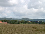
The TERRA.vita Nature Park is located in the German states of Lower Saxony
and North Rhine-Westphalia
and is divided into northern and southern areas. The park is also known as the Osnabrück Land Nature Park and sometimes by its old name of North Teutoburg Forest-Wiehen Hills Nature Park.
The woodlands of the Nature Park comprise about 70% of its total area.
 The northern part of the nature park begins in the Emsland
near Herzlake
and extends from there over the southern fringes of the Oldenburger Münsterland
and Osnabrück Land
in a southeast direction over the Ankum Heights
to Bramsche
. From there it widens out north of Osnabrück
over the Wiehen Hills eastwards and then over the gorge of Porta Westfalica
, continuing further to the east as far as the Bückeburg
, which lies east of the Weser and north of the Wesergebirge
; the park area thus extends into the northwestern part of the Wesergebirge.
. Er starts east of Hörstel
and runs through the Tecklenburg Land and Bad Iburg
in a southeasterly direction to Bielefeld
.
it runs into the Teutoburg Forest / Eggegebirge Nature Park.
Lower Saxony
Lower Saxony is a German state situated in north-western Germany and is second in area and fourth in population among the sixteen states of Germany...
and North Rhine-Westphalia
North Rhine-Westphalia
North Rhine-Westphalia is the most populous state of Germany, with four of the country's ten largest cities. The state was formed in 1946 as a merger of the northern Rhineland and Westphalia, both formerly part of Prussia. Its capital is Düsseldorf. The state is currently run by a coalition of the...
and is divided into northern and southern areas. The park is also known as the Osnabrück Land Nature Park and sometimes by its old name of North Teutoburg Forest-Wiehen Hills Nature Park.
The woodlands of the Nature Park comprise about 70% of its total area.
Northern area
Emsland
Landkreis Emsland is a district in Lower Saxony, Germany named after the river Ems. It is bounded by the districts of Leer, Cloppenburg and Osnabrück, the state of North Rhine-Westphalia , the district of Bentheim and the Netherlands .- History :For a long time the region of the Emsland was...
near Herzlake
Herzlake
Samtgemeinde Herzlake is a Samtgemeinde in the district Emsland in Lower Saxony, Germany at the Hase river.Following villages are situated in Herzlake:...
and extends from there over the southern fringes of the Oldenburger Münsterland
Oldenburger Münsterland
The Oldenburg Münsterland is the southern, predominantly Catholic portion of the former Grand Duchy of Oldenburg, now a part of Lower Saxony in Germany. Before 1803, it was part of the Prince-Bishopric of Münster . It comprises the modern day counties of Cloppenburg and Vechta, an area with over...
and Osnabrück Land
Osnabrück Land
Osnabrück Land is a region in southwest Lower Saxony in Germany, which extends into the state of North Rhine-Westphalia. Its centre is the town of Osnabrück. The region is dominated by the Teutoburg Forest and the River Hase...
in a southeast direction over the Ankum Heights
Ankum Heights
The Ankum Heights , also called the Fürstenau Hills , are a ridge of hills up to 140 m high in the western part of the state of Lower Saxony on the North German Plain.- Geography :...
to Bramsche
Bramsche
Bramsche is a town in the district of Osnabrück, Lower Saxony, Germany. It is about 20 km north of Osnabrück, at . Population is 30858 .In 1971/72 12 previously independent municipalities were included into the town.*Achmer*Balkum...
. From there it widens out north of Osnabrück
Osnabrück
Osnabrück is a city in Lower Saxony, Germany, some 80 km NNE of Dortmund, 45 km NE of Münster, and some 100 km due west of Hanover. It lies in a valley penned between the Wiehen Hills and the northern tip of the Teutoburg Forest...
over the Wiehen Hills eastwards and then over the gorge of Porta Westfalica
Porta Westfalica (gorge)
thumb|Weser watershedThe Porta Westfalica is a gorge and water gap, where the Weser river runs through the passage between the mountain chains of the Wiehengebirge in the west and the Wesergebirge in the east...
, continuing further to the east as far as the Bückeburg
Bückeburg
Bückeburg is a town in Lower Saxony, Germany, on the border with North Rhine Westphalia. It was once the capital of the tiny principality of Schaumburg-Lippe and is today located in the district of Schaumburg close to the northern slopes of the Weserbergland ridge...
, which lies east of the Weser and north of the Wesergebirge
Wesergebirge
The Wesergebirge is a low mountain chain up to high in the Weser Uplands in the German states of North Rhine-Westphalia and Lower Saxony....
; the park area thus extends into the northwestern part of the Wesergebirge.
Southern area
The southern part of the nature park lies in the northern Teutoburg ForestTeutoburg Forest
The Teutoburg Forest is a range of low, forested mountains in the German states of Lower Saxony and North Rhine-Westphalia which used to be believed to be the scene of a decisive battle in AD 9...
. Er starts east of Hörstel
Hörstel
Hörstel is a town in the district of Steinfurt, in North Rhine-Westphalia, Germany. It is situated near the junction of the Mittellandkanal and the Dortmund-Ems Canal, approx. 10 km east of Rheine.-References:...
and runs through the Tecklenburg Land and Bad Iburg
Bad Iburg
Bad Iburg is a town in the district of Osnabrück, in Lower Saxony, Germany. It is situated in the Teutoburg Forest, 16 km south of Osnabrück....
in a southeasterly direction to Bielefeld
Bielefeld
Bielefeld is an independent city in the Ostwestfalen-Lippe Region in the north-east of North Rhine-Westphalia, Germany. With a population of 323,000, it is also the most populous city in the Regierungsbezirk Detmold...
.
Neighbouring nature park
East of Bückeburg it meets the Weser Upland Schaumburg-Hameln Nature Park. Southeast of BielefeldBielefeld
Bielefeld is an independent city in the Ostwestfalen-Lippe Region in the north-east of North Rhine-Westphalia, Germany. With a population of 323,000, it is also the most populous city in the Regierungsbezirk Detmold...
it runs into the Teutoburg Forest / Eggegebirge Nature Park.