

List of life zones by region
Encyclopedia
The climate and ecology of different locations on the globe naturally separate into life zones, depending on elevation
, location, and latitude
. The generally strong dependency on elevation is known as altitudinal zonation
: the average temperature of a location decreases as the elevation increases.
The general effect of elevation depends on atmospheric physics. However, the specific climate and ecology of any particular location depends on specific features of that location. This article provides a list of life zones by region, in order to illustrate the features of life zones for regions around the globe.
Submontane, 700 - 1,000 m (Eastern Alps), 300 – 450 m (Central Uplands), European Beech
(Fagus sylvatica), Silver Fir or European Silver Fir (Abies alba) and Norway Spruce
(Picea abies). Coniferous forests by reforestation
limit around 800 m, North.
, Kenya, (0°9′0"S 37°18′0"E)
Vulcano Kibo - Uhuru Peak, 5,895 m rock and ice. As the conifers are absent, the Tree line is lower.
In the altitudes between 3,400 meters (11,000 feet) and 4,500 meters (15,000 feet) some of the most extreme examples of adaptations can be found. At altitudes below 3,400 meters (12,000 feet) the daily temperature fluctuations are less extreme, the average daily temperature steadily increases, and the growth forms and ecology of the Dendroseneico
reflect the increased influence of biotic factors (such as competition for light) over abiotic factor
s (such as nightly frost).
(Lan Cang) and Salween (Nujiang) rivers and is the joint of the Palearctic ecozone and the Indomalaya ecozone.
Elevation
The elevation of a geographic location is its height above a fixed reference point, most commonly a reference geoid, a mathematical model of the Earth's sea level as an equipotential gravitational surface ....
, location, and latitude
Latitude
In geography, the latitude of a location on the Earth is the angular distance of that location south or north of the Equator. The latitude is an angle, and is usually measured in degrees . The equator has a latitude of 0°, the North pole has a latitude of 90° north , and the South pole has a...
. The generally strong dependency on elevation is known as altitudinal zonation
Altitudinal zonation
Altitudinal zonation in mountainous regions describes the natural layering of ecosystems that occurs at distinct altitudes due to varying environmental conditions. Temperature, humidity, soil composition, and solar radiation are important factors in determining altitudinal zones, which consequently...
: the average temperature of a location decreases as the elevation increases.
The general effect of elevation depends on atmospheric physics. However, the specific climate and ecology of any particular location depends on specific features of that location. This article provides a list of life zones by region, in order to illustrate the features of life zones for regions around the globe.
Central Europe: Switzerland & Germany
- Planar, under 300 m (Eastern AlpsEastern AlpsEastern Alps is the name given to the eastern half of the Alps, usually defined as the area east of the Splügen Pass in eastern Switzerland. North of the Splügen Pass, the Posterior Rhine forms the border, and south of the pass, the Liro river and Lake Como form the boundary line.-Geography:The...
), under 150 m (Central UplandsCentral UplandsThe Central Uplands is one of the three major natural regions of Germany and covers most of the land area of the country. To the north lies the North German Plain or Northern Lowland; to the south, the Alps and the Alpine Foreland.- Formation :...
), agriculture.
- Colin, 300 – 800 m (Eastern Alps), 150 – 300 m (Central Uplands), oakOakAn oak is a tree or shrub in the genus Quercus , of which about 600 species exist. "Oak" may also appear in the names of species in related genera, notably Lithocarpus...
limit (Quercus spp.). European BeechEuropean BeechFagus sylvatica, the European Beech or Common Beech, is a deciduous tree belonging to the beech family Fagaceae.-Natural range:...
(Fagus sylvatica), Sessile oak (Quercus petraea), Pedunculate oak or English oak (Quercus robur), European or common hornbeam (Carpinus betulus) and small-leaved Lime (Tilia cordataTilia cordataTilia cordata is a species of Tilia native to much of Europe and western Asia, north to southern Great Britain , central Scandinavia, east to central Russia, and south to central Spain, Italy, Bulgaria, Turkey, and the Caucasus; in the south of its range it is restricted to...
). Grape crop limit (Vitis spp.), around 600 m, Switzerland, North, south-facing slopes, estimated 7.5°C. Crops: maizeMaizeMaize known in many English-speaking countries as corn or mielie/mealie, is a grain domesticated by indigenous peoples in Mesoamerica in prehistoric times. The leafy stalk produces ears which contain seeds called kernels. Though technically a grain, maize kernels are used in cooking as a vegetable...
for feed; sweet maize (Zea mays).
Submontane, 700 - 1,000 m (Eastern Alps), 300 – 450 m (Central Uplands), European Beech
European Beech
Fagus sylvatica, the European Beech or Common Beech, is a deciduous tree belonging to the beech family Fagaceae.-Natural range:...
(Fagus sylvatica), Silver Fir or European Silver Fir (Abies alba) and Norway Spruce
Norway Spruce
Norway Spruce is a species of spruce native to Europe. It is also commonly referred to as the European Spruce.- Description :...
(Picea abies). Coniferous forests by reforestation
Reforestation
Reforestation is the natural or intentional restocking of existing forests and woodlands that have been depleted, usually through deforestation....
limit around 800 m, North.
- Montane, 800 – 1,200 m (Eastern Alps), 450 – 650 m (Central Uplands), ryeRyeRye is a grass grown extensively as a grain and as a forage crop. It is a member of the wheat tribe and is closely related to barley and wheat. Rye grain is used for flour, rye bread, rye beer, some whiskeys, some vodkas, and animal fodder...
(Secale cereale) crop limit and wheatWheatWheat is a cereal grain, originally from the Levant region of the Near East, but now cultivated worldwide. In 2007 world production of wheat was 607 million tons, making it the third most-produced cereal after maize and rice...
(Triticum spp.) crop limit.
- Mean Montane, 1,000 – 1,400 m (Eastern Alps), 650 – 800 m (Central Uplands). Limit of the whole year populated areas, limit of a growing seasonGrowing seasonIn botany, horticulture, and agriculture the growing season is the period of each year when native plants and ornamental plants grow; and when crops can be grown....
of 100 days.
- Altimontane, 1,300 – 1,850 m (Eastern Alps), 800 – 1,500 m (Central Uplands). Deciduous forests limit, Sycamore Maple (Acer pseudoplatanus) and European BeechEuropean BeechFagus sylvatica, the European Beech or Common Beech, is a deciduous tree belonging to the beech family Fagaceae.-Natural range:...
(Fagus sylvatica).
- Subalpine, 1,500 – 2,500 m (Eastern Alps), above 1,500 m (Central Uplands), Scots PineScots PinePinus sylvestris, commonly known as the Scots Pine, is a species of pine native to Europe and Asia, ranging from Scotland, Ireland and Portugal in the west, east to eastern Siberia, south to the Caucasus Mountains, and as far north as well inside the Arctic Circle in Scandinavia...
(Pinus sylvestris), Norway SpruceNorway SpruceNorway Spruce is a species of spruce native to Europe. It is also commonly referred to as the European Spruce.- Description :...
(Picea abies), Swiss PineSwiss PineThe Swiss Pine or Arolla Pine, Pinus cembra, is a species of pine tree that occurs in the Alps and Carpathian Mountains of central Europe, in Poland , Switzerland, France, Italy, Austria, Germany, Slovenia, Slovakia, Ukraine and Romania. It typically grows at to altitude. It often reaches the...
(Pinus cembra, Arve or Zirbel) limit and European LarchEuropean LarchLarix decidua, common name European larch, is a species of larch native to the mountains of central Europe, in the Alps and Carpathians, with disjunct lowland populations in northern Poland and southern Lithuania.-Description:...
(Larix decidua) limit, 2,000 m, some specimens up to 2,850 m, south-facing slopes. Tree line and KrummholzKrummholzKrummholz or Krumholtz formation — also called Knieholz — is a particular feature of subarctic and subalpine tree line landscapes. Continual exposure to fierce, freezing winds causes vegetation to become stunted and deformed...
zone or ecotoneEcotoneAn ecotone is a transition area between two biomes but different patches of the landscape, such as forest and grassland. It may be narrow or wide, and it may be local or regional...
(stunted subalpine bushes), Sub-alpine meadow and Alpine climateAlpine climateAlpine climate is the average weather for a region above the tree line. This climate is also referred to as mountain climate or highland climate....
.
- Alpine, 2,000 - 3,000 m (Eastern Alps), Montane grasslands and shrublandsMontane grasslands and shrublandsMontane grasslands and shrublands is a biome defined by the World Wildlife Fund. The biome includes high altitude grasslands and shrublands around the world....
. Mountain PineMountain PinePinus mugo, the Mountain Pine or Mugo Pine, is a high-altitude European pine, found in the Pyrenees, Alps, Erzgebirge, Carpathians, northern Apennines and Balkan Peninsula mountains from 1,000 m to 2,200 m, occasionally as low as 200 m in the north of the range in Germany and Poland, and as high...
or Mugo Pine (Pinus mugo) limit. Alpine meadows just used in the warm season.
- Nival, above 3,000 m (Eastern Alps), alpine desert, permafrostPermafrostIn geology, permafrost, cryotic soil or permafrost soil is soil at or below the freezing point of water for two or more years. Ice is not always present, as may be in the case of nonporous bedrock, but it frequently occurs and it may be in amounts exceeding the potential hydraulic saturation of...
, screeScreeScree, also called talus, is a term given to an accumulation of broken rock fragments at the base of crags, mountain cliffs, or valley shoulders. Landforms associated with these materials are sometimes called scree slopes or talus piles...
and above snow lineSnow lineThe climatic snow line is the point above which snow and ice cover the ground throughout the year. The actual snow line may seasonally be significantly lower....
.
Mediterranean: Corsica
- Thermomediterranean vegetation belt, 150 m (south) and 100 m (north); shrub of Pistacia lentiscus and dense mediterranean coastal scrub (maquis) with Quercus ilex, PhillyreaPhillyreaPhillyrea is a genus of two species of flowering plants in the family Oleaceae, native to the Mediterranean region, the Canary Islands and Madeira....
, Myrtus communis and wild olive (Olea europea var. sylvestris). - Mesomediterranean vegetation belt, up to 700 m (northern slopes) and 900 m (southern slopes); Erica arborea, Arbutus unedo and Quercus ilex. Forests include Quercus suber, Pinus pinaster, Quercus pubescens and Castanea sativa too.
- Supramediterranean vegetation belt, 500– 700 m up to 900- 1,000 m (northern slopes), or 800- 1,000 m to 1,200- 1,350 m (southern slopes); Erica arborea, Quercus ilex, Quercus petraea, Pinus nigra ssp. laricio, AlmusAlmusAlmus is a town and a district of Tokat Province in the Black Sea region of Turkey. The mayor is Hasan Hüseyin Arıkan ....
cordata, Ilex aquifolium, Taxus baccataTaxus baccataTaxus baccata is a conifer native to western, central and southern Europe, northwest Africa, northern Iran and southwest Asia. It is the tree originally known as yew, though with other related trees becoming known, it may be now known as the English yew, or European yew.-Description:It is a small-...
and OstryaOstryaOstrya is a genus of eight to ten small deciduous trees belonging to the birch family Betulaceae. Its common name is Hophornbeam in American English and Hop-hornbeam in British English. It may also be called ironwood, a name shared with a number of other plants.The genus is native in southern...
carpinifolia. - Montane vegetation belt, 900- 1,000 m to 1,600 m (northern slopes) and 1,300 to 1,800 m (southern slopes); forests of Pinus nigra ssp. laricio, Fagus sylvatica and Abies alba. Quercus ilex, Quercus pubescens, Pinus pinaster, Castanea sativa and Erica arborea not present anymore.
- Cryo-oromediterranean vegetation belt, 1,700- 1,800 m to 2,200 m (only southern slopes); above the upper Tree line (Pinus nigra ssp. laricio goes up to 1,800 m), dwarft bushes of GenistaGenistaGenista is a genus of legumes which includes many species of broom. Many of these brooms are notorious as noxious weeds.Species include:*Genista aetnensis - Mount Etna broom*Genista anglica - petty whin, needle furze*Genista canariensis...
lobelii var. lobelioides, AstragalusAstragalusAstragalus is a large genus of about 3,000 species of herbs and small shrubs, belonging to the legume family Fabaceae, subfamily Faboideae. The genus is native to temperate regions of the Northern Hemisphere...
sirinicus ssp. genargenteus, AnthyllisAnthyllisAnthyllis is a genus of plants in the family Fabaceae. This genus contains both herbaceous and shrubby species and is distributed in Europe, the Middle East and North Africa. The most widespread and familiar species is Kidney Vetch Anthyllis is a genus of plants in the family Fabaceae. This genus...
hemanniae, ThymusThymusThe thymus is a specialized organ of the immune system. The thymus produces and "educates" T-lymphocytes , which are critical cells of the adaptive immune system....
herbabarona, BerberisBerberisBerberis , the barberries or pepperidge bushes, is a genus of about 450-500 species of deciduous and evergreen shrubs from 1-5 m tall with thorny shoots, native to the temperate and subtropical regions of Europe, Asia, Africa, North America and South America. They are closely related to the genus...
aetnensis and Juniperus communisJuniperus communisJuniperus communis, the Common Juniper, is a species in the genus Juniperus, in the family Cupressaceae. It has the largest range of any woody plant, throughout the cool temperate Northern Hemisphere from the Arctic south in mountains to around 30°N latitude in North America, Europe and Asia.-...
ssp. alpina. - Subalpine vegetation belt, 1,400- 1,600 m to 2,100 m (only northern slopes); Alnus viridis ssp. suaveolens, Acer pseudoplatanus, Sorbus aucupariaSorbus aucupariaSorbus aucuparia , is a species of the genus Sorbus, native to most of Europe except for the far south, and northern Asia...
ssp. praemorsa. - Alpine vegetation belt, above 2,100 m; sparse vegetation.
- Indicator plantIndicator plant- Definition :Since a plant species or plant community acts as a measure of environmental conditions, it is referred to as biological indicators/bioindicators/phytoindicators...
s: Rock Speedwell (VeronicaVeronica (plant)Veronica is the largest genus in the flowering plant family Plantaginaceae, with about 500 species; it was formerly classified in the family Scrophulariaceae...
fruticans), PotentillaPotentillaPotentilla is the genus of typical cinquefoils, containing about 500 species of annual, biennial and perennial herbs in the rose family Rosaceae. They are generally Holarctic in distribution, though some may even be found in montane biomes of the New Guinea Highlands...
crassinervia, ArmeriaArmeriaArmeria is the botanical name for a genus of flowering plants. These plants are sometimes known as "thrift" or as the "sea pinks" as they are often found on coastlines...
pusilla, CerastiumCerastiumCerastium is a genus of annual, winter annual, or perennial plants belonging to the family Caryophyllaceae. The around 100 species are commonly called Mouse-ear chickweed; different species are found nearly worldwide but the greatest concentration is mainly from the northern temperate areas of the...
thomasii, PhyteumaPhyteumaPhyteuma is a genus of about 40-45 species of flowering plants in the family Campanulaceae, native to Europe and western Asia. The common name is Rampion. Rampion features prominently in some versions of the fairy tale Rapunzel...
serratum, StachysStachysStachys is one of the largest genera in the flowering plant family Lamiaceae. Estimates of the number of species in the genus vary from about 300, to about 450. The type species for the genus is Stachys sylvatica. Stachys is in the subfamily Lamioideae...
corsica e Helichrysum frigidum.
Tropical Andes 10°S
Classic Version - Regions of the Amazonic Side- Sea level, 22 to 24 °C (71.6 to 75.2 F), but the cold Humboldt Current generates fog.
- Tierra calienteTierra calienteTierra caliente is a pseudo-climatalogical term used in Latin America to refer to those places within that realm which have a distinctly tropical climate...
(Hot land) up to 750–1000 m (2,460.6–3,280.8 ft). - Tierra templadaTierra templadaTierra templada is a pseudoclimatological term used in Latin America to refer to places within that realm which are either located in the tropics at a moderately high elevation, or are marginally outside the astronomical tropics, producing a somewhat cooler overall climate than that found in the...
(Temperate land) up to 1850–2000 m (6,069.6–6,561.7 ft). The warmest month has an average temperature of below 22 °C (71.6 °F). - Tierra friaTierra fríaTierra fría is a pseudoclimatological term used in parts of Latin America to refer to mountain locations within that cultural realm, where high elevation results in a markedly cooler climate than that encountered in the lowlands at a comparable latitude.To a climatologist, the term is inaccurate,...
(Cool land) below 3600 metres (11,811 ft). The warmest month has an average temperature of below 18 °C (64.4 °F). - Tierra heladaTierra heladaTierra helada is a term used in Latin America to refer to the highest places found within the Andes mountains.Tierra helada is for the Montane grasslands and shrublands, Sunis, Punas and Paramos between the Treeline and the Snow line...
(Cold land) above 3600 metres (11,811 ft). The tree line occurs when the warmest month has an average temperature of below 10 °C (50 °F). - Tierra NevadaJancaJanca is one of the eight Natural Regions of Peru . It is located in the frozen heights where the condor lives.The fauna in this region is limited because of the very cold weather...
, above the Snow lineSnow lineThe climatic snow line is the point above which snow and ice cover the ground throughout the year. The actual snow line may seasonally be significantly lower....
at 4500–5500 m (14,763.8–18,044.6 ft).
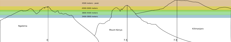
Kilimanjaro
Kilimanjaro, Tanzania (3°7′0"S 37°35′0"E) & Mount KenyaMount Kenya
Mount Kenya is the highest mountain in Kenya and the second-highest in Africa, after Kilimanjaro. The highest peaks of the mountain are Batian , Nelion and Point Lenana . Mount Kenya is located in central Kenya, just south of the equator, around north-northeast of the capital Nairobi...
, Kenya, (0°9′0"S 37°18′0"E)
- MalindiMalindiMalindi is a town on Malindi Bay at the mouth of the Galana River, lying on the Indian Ocean coast of Kenya. It is 120 kilometres northeast of Mombasa. The population of Malindi is 117,735 . It is the capital of the Malindi District.Tourism is the major industry in Malindi. The city is...
; Kenya; 23 m; average annual temperature 26.5 °C; average annual precipitation 1'095 mm; 3°14′0"S 40°6′0"E - Kilimanjaro Base at around 1,300, crops at around 1,300 - 1,800 m (West Slope is too dry): CoffeeCoffeeCoffee is a brewed beverage with a dark,init brooo acidic flavor prepared from the roasted seeds of the coffee plant, colloquially called coffee beans. The beans are found in coffee cherries, which grow on trees cultivated in over 70 countries, primarily in equatorial Latin America, Southeast Asia,...
(Coffea arabica), BananaBananaBanana is the common name for herbaceous plants of the genus Musa and for the fruit they produce. Bananas come in a variety of sizes and colors when ripe, including yellow, purple, and red....
(Musa spp.), MangoMangoThe mango is a fleshy stone fruit belonging to the genus Mangifera, consisting of numerous tropical fruiting trees in the flowering plant family Anacardiaceae. The mango is native to India from where it spread all over the world. It is also the most cultivated fruit of the tropical world. While...
(Mangifera indicaMangifera indicaMangifera indica is a species of mango in the Anacardiaceae family. It is found in the wild in India and cultivated varieties have been introduced to other warm regions of the world...
), AvocadoAvocadoThe avocado is a tree native to Central Mexico, classified in the flowering plant family Lauraceae along with cinnamon, camphor and bay laurel...
(Persea americana). Traditional Agriculture uses a multilayer system to save water: Bananas are under the shadows of Mango trees, Avocado trees and AlbiziaAlbiziaAlbizia is a genus of about 150 species of mostly fast-growing subtropical and tropical trees and shrubs in the subfamily Mimosoideae of the legume family, Fabaceae. The genus is pantropical, occurring in Asia, Africa, Madagascar, Central, South, and southern North America and Australia, but mostly...
schimperiana var. amaniensis, Coffee bushes and vegetables are under the shadows of Bananas; - Nairobi International AirportJomo Kenyatta International Airport-Charter airlines:-Cargo airlines:-Other facilities:The Kenya Civil Aviation Authority has its head office in the KAA Complex on the airport property. African Express Airways has its head office on the airport property...
; Kenya; 1,624 m; average annual temperature 19.0 °C; average annual precipitation 889 mm; 01°19′09"S 36°55′39"E - Subtropical moist broadleaf forests, between 1,400 m and 3,000 m (4,600-9,800 ft), max. 3,300 m. BambooBambooBamboo is a group of perennial evergreens in the true grass family Poaceae, subfamily Bambusoideae, tribe Bambuseae. Giant bamboos are the largest members of the grass family....
Zone needs quite a lot of water, it is missing at the Kilimanjaro because of the agriculture; - Timberline forest, "goat's beard" lichen (UsneaUsneaUsnea is the generic and scientific name for several species of lichen in the family Parmeliaceae, that generally grow hanging from tree branches, resembling grey or greenish hair. It is sometimes referred to commonly as Old Man's Beard, Beard Lichen, or Treemoss...
spp.), between 3,000 and 3,500 m (9,850-11,500 ft); - Tree line, 2,700 - 3,000 m (8,900-9,800 ft), max. 3,500 m (Coniferaes are absent);
- Heathland and chaparral, between 3,200 and 3,800 m (10,500-12,500 ft). Giant Lobelias, up to ca. 4,000 m; Subalpine forests with EricaceaeEricaceaeThe Ericaceae, commonly known as the heath or heather family, is a group of mostly calcifuge flowering plants. The family is large, with roughly 4000 species spread across 126 genera, making it the 14th most speciose family of flowering plants...
up to 4,100 m (as heigh as 10 m); - Afro-alpine zone, above about 3,800 m (12,500 ft), Giant GroundselsDendrosenecioDendrosenecio is a genus of flowering plants belonging to the family Asteraceae. It is a segregate of Senecio, in which it formed the subgenus Dendrosenecio...
up to 4,500 m; - Nival zone, usually above 4,500 m (14,750 ft).
Vulcano Kibo - Uhuru Peak, 5,895 m rock and ice. As the conifers are absent, the Tree line is lower.
Vegetation zones
In the altitudes between 3,400 meters (11,000 feet) and 4,500 meters (15,000 feet) some of the most extreme examples of adaptations can be found. At altitudes below 3,400 meters (12,000 feet) the daily temperature fluctuations are less extreme, the average daily temperature steadily increases, and the growth forms and ecology of the Dendroseneico
Dendrosenecio
Dendrosenecio is a genus of flowering plants belonging to the family Asteraceae. It is a segregate of Senecio, in which it formed the subgenus Dendrosenecio...
reflect the increased influence of biotic factors (such as competition for light) over abiotic factor
Abiotic components
In biology and ecology, abiotic components are non-living chemical and physical factors in the environment which affect ecosystems. Abiotic phenomena underlie all of biology. Abiotic factors, while generally downplayed, can have enormous impact on ramonds evolution...
s (such as nightly frost).
Jade Dragon Snow Mountains
The Jade Dragon Snow Mountains contain the glacier nearest of the Equator on the North Hemisphere. The landmarks 4,506 m and 4,680 m at the end of the glacier can be achieved through the cable car from Ganhaizi (tibetan for dry lake, a grassland with conifers at 3,400 m). The mountain desert begins around 4,000 m. The Three Parallel Rivers of Yunnan (Unesco World Heritage Site) encompasses the watershed areas of the Yangtse (Jinsha), MekongMekong
The Mekong is a river that runs through China, Burma, Laos, Thailand, Cambodia and Vietnam. It is the world's 10th-longest river and the 7th-longest in Asia. Its estimated length is , and it drains an area of , discharging of water annually....
(Lan Cang) and Salween (Nujiang) rivers and is the joint of the Palearctic ecozone and the Indomalaya ecozone.
- Shanzidou Peak; 5,596 m (18,359 ft); 27°05′54"N 100°10′30"E
- Lijiang; YunnanYunnanYunnan is a province of the People's Republic of China, located in the far southwest of the country spanning approximately and with a population of 45.7 million . The capital of the province is Kunming. The province borders Burma, Laos, and Vietnam.Yunnan is situated in a mountainous area, with...
is at 2,600 m, the Black Dragon PoolBlack Dragon PoolThe Black Dragon Pool is a famous pond in the scenic Jade Spring Park located at the foot of Elephant Hill, a short walk north of the Old Town of Lijiang in Yunnan province, China. It was built in 1737 during the Qing Dynasty and offers a spectacular view on the region's tallest mountain, Jade...
is 15 km south of the mountains; 26°52′34"N 100°13′48"E - Quambo/ Changdu; 3,306 m; avg annual temperature 7.5 °C; avg annual precipitation 463 mm; 31°09′00"N 97°10′00"E
- Sichuan XichangXichangXichang is a city in and the seat of the Liangshan Yi Autonomous Prefecture, in the south of Sichuan province, People's Republic of China. In 2004 it had a population of 126,700.-Geography:...
; 1,591 m; avg annual temperature 16.9 °C; avg annual precipitation 974 mm; 27°54′00"N 102°16′00"E - Taiwan Airport; 48 m; avg annual temperature 21.6 °C; avg annual precipitation 1,714 mm; 25°04′35"N 121°13′26"E
- HaikouHaikouHǎikǒu , is the capital and most populous city of Hainan Province, in the People's Republic of China. It is situated on the northern coast of Hainan, by the mouth of the Nandu River...
airport, Hainan; 15 m; avg annual temperature 23.9 °C; avg annual precipitation 1,613 mm; 20°01′04"N 110°20′01"E - HanoiHanoiHanoi , is the capital of Vietnam and the country's second largest city. Its population in 2009 was estimated at 2.6 million for urban districts, 6.5 million for the metropolitan jurisdiction. From 1010 until 1802, it was the most important political centre of Vietnam...
; 15 m; avg annual temperature 23.8 °C; avg annual precipitation 1,682 mm; 21°02′00"N 105°51′00"E
Ferrocarril Chihuahua al Pacífico
- Mazatlan; 4 m; average annual temperature 24.3 °C, average annual precipitation 860 mm, 23°12′0"N 106°25′0"W
- City of Los MochisLos MochisLos Mochis is a coastal city in northern Sinaloa, Mexico. It serves as the municipal seat of the municipality of Ahome. As of the 2010 census, the population was 256,613, which was 61 percent of the municipality's population....
, SinaloaSinaloaSinaloa officially Estado Libre y Soberano de Sinaloa is one of the 31 states which, with the Federal District, comprise the 32 Federal Entities of Mexico. It is divided in 18 municipalities and its capital city is Culiacán Rosales....
and its port Topolobampo; sea level - Rising as high as 2,400 m (7,900 ft) above sea level near the continental divide (Divisadero)
- ChihuahuaChihuahua, ChihuahuaThe city of Chihuahua is the state capital of the Mexican state of Chihuahua. It has a population of about 825,327. The predominant activity is industry, including domestic heavy, light industries, consumer goods production, and to a smaller extent maquiladoras.-History:It has been said that the...
(Ferrocarril Chihuahua al Pacífico), Chihuahua; 1,435 m; average annual temperature 18.4 °C, average annual precipitation 368 mm, 28°38′0"N 106°05′0"W
Darjeeling Himalayan Railway
- Dacca, BangladeshBangladeshBangladesh , officially the People's Republic of Bangladesh is a sovereign state located in South Asia. It is bordered by India on all sides except for a small border with Burma to the far southeast and by the Bay of Bengal to the south...
; 9 m; average annual temperature 25.6 °C, average annual precipitation 2,039 mm, 23°46′0"N 90°23′0"E - Calcutta, West BengalWest BengalWest Bengal is a state in the eastern region of India and is the nation's fourth-most populous. It is also the seventh-most populous sub-national entity in the world, with over 91 million inhabitants. A major agricultural producer, West Bengal is the sixth-largest contributor to India's GDP...
; 6 m; average annual temperature 26.9 °C, average annual precipitation 1,739 mm, 22°32′0"N 88°20′0"E - SiliguriSiliguriSiliguri is a city in the Indian state of West Bengal. It is located in the Siliguri Corridor or Chicken's Neck - a very narrow strip of land linking mainland India to its north-eastern states. It is also the transit point for air, road and rail traffic to the neighbouring countries of Nepal,...
Town, West Bengal; 122 m; 26°42′36"N 88°25′48"E - CherrapunjiCherrapunjiCherrapunji , is a subdivisional town in the East Khasi Hills district in the Indian state of Meghalaya. It is credited as being the second wettest place on Earth...
, MeghalayaMeghalayaMeghalaya is a state in north-eastern India. The word "Meghalaya" literally means the Abode of Clouds in Sanskrit and other Indic languages. Meghalaya is a hilly strip in the eastern part of the country about 300 km long and 100 km wide, with a total area of about 8,700 sq mi . The...
; 1,313m; average annual temperature 17.3 °C, average annual precipitation 11,777 mm, 25°15′0"N 91°44′0"E - Darjeeling (Darjeeling Himalayan RailwayDarjeeling Himalayan RailwayThe Darjeeling Himalayan Railway, nicknamed the "Toy Train", is a narrow gauge railway from New Jalpaiguri to Darjeeling in West Bengal, run by the Indian Railways....
), West Bengal; 2,127 m; average annual temperature 11.8°C, average annual precipitation 3,037 mm, 27°3′0"N 88°16′0"E
Other regions
- Life zones of the North Cascades in the Pacific Northwest of AmericaEcology of the North CascadesThe Ecology of the North Cascades is heavily influenced by the high elevation and rain shadow effects of the mountain range. The North Cascades is a section of the Cascade Range from the South Fork of the Snoqualmie River in Washington, United States, to the confluence of the Thompson and Fraser...
- Life zones of the Sierra Nevada in California