
Central Uplands
Encyclopedia
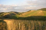
The Central Uplands is one of the three major natural regions of Germany
and covers most of the land area of the country. To the north lies the North German Plain
or Northern Lowland; to the south, the Alps
and the Alpine Foreland.
, i.e. about 350 million years ago, Variscan mountain ranges
were formed in central Europe by the uplifting caused by tectonic plate collision. Immediately after their formation the erosion of the mountains began under the influence of exogenous processes during the Permian
period.
During the Triassic
period, which began about 225 million years ago, what is now central Europe was sometimes above and sometimes below sea level. As a result there are various layers of sedimentary rock in the Central Uplands: in most cases new red sandstone
has been laid down as the terrestrial layer of rock and keuper
and muschelkalk
as marine sedimentary layers. The Jurassic
period primarily saw the formation of limestone
, whilst chalk
was the main deposition from the Cretaceous
period.
With the beginning of the Cenozoic
era, some 70 million years ago, the process of erosion of the Hercynian mountain ranges changed. During the Tertiary
, alpidic mountain building
took place in the course of which strong forces on the stumps of the Hercynian mountains. As these rocks were already folded, further tension led to cracks and fractures, which in turn created fault blocks. These blocks were later uplifted (forming horsts such as the Harz
), or downfaulted (trough faults or graben
such as the Upper Rhine Valley
) or thrust over one another (tilted fault blocks such as the Ore Mountains
). Thus the German Central Uplands exhibit the widest variety of forms, something that is also attributable to the erosion of sediments from the Mesozoic
(Triassic
, Jurassic
and Cretaceous
). In some ranges the sediments have been relatively well-preserved, in others they have been carried away completely. The determining factor is the geographical location and associated intensity of exogenous processes.
Natural regions of Germany
This division of Germany into major natural regions takes account primarily of geomorphological, geological, hydrological and pedological criteria in order to divide the country into large, physical units with a common geographical basis...
and covers most of the land area of the country. To the north lies the North German Plain
North German plain
The North German Plain or Northern Lowland is one of the major geographical regions of Germany. It is the German part of the North European Plain...
or Northern Lowland; to the south, the Alps
Alps
The Alps is one of the great mountain range systems of Europe, stretching from Austria and Slovenia in the east through Italy, Switzerland, Liechtenstein and Germany to France in the west....
and the Alpine Foreland.
Formation
The German Central Uplands, like the Scandinavian and British mountain ranges and the Urals, belong to the oldest mountains of Europe, even if their present-day appearance has only developed relatively recently. In the CarboniferousCarboniferous
The Carboniferous is a geologic period and system that extends from the end of the Devonian Period, about 359.2 ± 2.5 Mya , to the beginning of the Permian Period, about 299.0 ± 0.8 Mya . The name is derived from the Latin word for coal, carbo. Carboniferous means "coal-bearing"...
, i.e. about 350 million years ago, Variscan mountain ranges
Variscan orogeny
The Variscan orogeny is a geologic mountain-building event caused by Late Paleozoic continental collision between Euramerica and Gondwana to form the supercontinent of Pangaea.-Naming:...
were formed in central Europe by the uplifting caused by tectonic plate collision. Immediately after their formation the erosion of the mountains began under the influence of exogenous processes during the Permian
Permian
The PermianThe term "Permian" was introduced into geology in 1841 by Sir Sir R. I. Murchison, president of the Geological Society of London, who identified typical strata in extensive Russian explorations undertaken with Edouard de Verneuil; Murchison asserted in 1841 that he named his "Permian...
period.
During the Triassic
Triassic
The Triassic is a geologic period and system that extends from about 250 to 200 Mya . As the first period of the Mesozoic Era, the Triassic follows the Permian and is followed by the Jurassic. Both the start and end of the Triassic are marked by major extinction events...
period, which began about 225 million years ago, what is now central Europe was sometimes above and sometimes below sea level. As a result there are various layers of sedimentary rock in the Central Uplands: in most cases new red sandstone
New Red Sandstone
The New Red Sandstone is a chiefly British geological term for the beds of red sandstone and associated rocks laid down throughout the Permian to the beginning of the Triassic that underlie the Jurassic Lias; the term distinguishes it from the Old Red Sandstone which is largely Devonian in...
has been laid down as the terrestrial layer of rock and keuper
Keuper
The Keuper is a lithostratigraphic unit in the subsurface of large parts of west and central Europe. The Keuper consists of dolostone, shales or claystones and evaporites that were deposited during the Middle and Late Triassic epochs...
and muschelkalk
Muschelkalk
The Muschelkalk is a sequence of sedimentary rock strata in the geology of central and western Europe. It has a Middle Triassic age and forms the middle part of the Germanic Trias, that further consists of the Buntsandstein and Keuper...
as marine sedimentary layers. The Jurassic
Jurassic
The Jurassic is a geologic period and system that extends from about Mya to Mya, that is, from the end of the Triassic to the beginning of the Cretaceous. The Jurassic constitutes the middle period of the Mesozoic era, also known as the age of reptiles. The start of the period is marked by...
period primarily saw the formation of limestone
Limestone
Limestone is a sedimentary rock composed largely of the minerals calcite and aragonite, which are different crystal forms of calcium carbonate . Many limestones are composed from skeletal fragments of marine organisms such as coral or foraminifera....
, whilst chalk
Chalk
Chalk is a soft, white, porous sedimentary rock, a form of limestone composed of the mineral calcite. Calcite is calcium carbonate or CaCO3. It forms under reasonably deep marine conditions from the gradual accumulation of minute calcite plates shed from micro-organisms called coccolithophores....
was the main deposition from the Cretaceous
Cretaceous
The Cretaceous , derived from the Latin "creta" , usually abbreviated K for its German translation Kreide , is a geologic period and system from circa to million years ago. In the geologic timescale, the Cretaceous follows the Jurassic period and is followed by the Paleogene period of the...
period.
With the beginning of the Cenozoic
Cenozoic
The Cenozoic era is the current and most recent of the three Phanerozoic geological eras and covers the period from 65.5 mya to the present. The era began in the wake of the Cretaceous–Tertiary extinction event at the end of the Cretaceous that saw the demise of the last non-avian dinosaurs and...
era, some 70 million years ago, the process of erosion of the Hercynian mountain ranges changed. During the Tertiary
Tertiary
The Tertiary is a deprecated term for a geologic period 65 million to 2.6 million years ago. The Tertiary covered the time span between the superseded Secondary period and the Quaternary...
, alpidic mountain building
Alpine orogeny
The Alpine orogeny is an orogenic phase in the Late Mesozoic and Tertiary that formed the mountain ranges of the Alpide belt...
took place in the course of which strong forces on the stumps of the Hercynian mountains. As these rocks were already folded, further tension led to cracks and fractures, which in turn created fault blocks. These blocks were later uplifted (forming horsts such as the Harz
Harz
The Harz is the highest mountain range in northern Germany and its rugged terrain extends across parts of Lower Saxony, Saxony-Anhalt and Thuringia. The name Harz derives from the Middle High German word Hardt or Hart , latinized as Hercynia. The legendary Brocken is the highest summit in the Harz...
), or downfaulted (trough faults or graben
Graben
In geology, a graben is a depressed block of land bordered by parallel faults. Graben is German for ditch. Graben is used for both the singular and plural....
such as the Upper Rhine Valley
Upper Rhine Plain
The Upper Rhine Plain, Rhine Rift Valley or Upper Rhine Graben is a major rift, straddling the border between France and Germany. It forms part of the European Cenozoic Rift System, which extends across central Europe...
) or thrust over one another (tilted fault blocks such as the Ore Mountains
Ore Mountains
The Ore Mountains in Central Europe have formed a natural border between Saxony and Bohemia for many centuries. Today, the border between Germany and the Czech Republic runs just north of the main crest of the mountain range...
). Thus the German Central Uplands exhibit the widest variety of forms, something that is also attributable to the erosion of sediments from the Mesozoic
Mesozoic
The Mesozoic era is an interval of geological time from about 250 million years ago to about 65 million years ago. It is often referred to as the age of reptiles because reptiles, namely dinosaurs, were the dominant terrestrial and marine vertebrates of the time...
(Triassic
Triassic
The Triassic is a geologic period and system that extends from about 250 to 200 Mya . As the first period of the Mesozoic Era, the Triassic follows the Permian and is followed by the Jurassic. Both the start and end of the Triassic are marked by major extinction events...
, Jurassic
Jurassic
The Jurassic is a geologic period and system that extends from about Mya to Mya, that is, from the end of the Triassic to the beginning of the Cretaceous. The Jurassic constitutes the middle period of the Mesozoic era, also known as the age of reptiles. The start of the period is marked by...
and Cretaceous
Cretaceous
The Cretaceous , derived from the Latin "creta" , usually abbreviated K for its German translation Kreide , is a geologic period and system from circa to million years ago. In the geologic timescale, the Cretaceous follows the Jurassic period and is followed by the Paleogene period of the...
). In some ranges the sediments have been relatively well-preserved, in others they have been carried away completely. The determining factor is the geographical location and associated intensity of exogenous processes.
Most important ranges
The following table lists the hills over 300 m high that are generally considered to be part of the Central Uplands. The coordinates give the location of the highest point in each case. Many of the uplands overlap. The ranges are listed in order of height.| Hill range | Highest Elevation | Height (m) | Coordinates | Precision |
|---|---|---|---|---|
| Wiehen Hills | Heidbrink Heidbrink The Heidbrink is a hill which lies south of Lübbecke in central Germany and, at , is the highest peak in the Wiehen Hills. It is also the highest elevation in the district of Minden-Lübbecke in the German state of North Rhine-Westphalia... |
320 | 52°17′29"N 08°38′13"E | ± 30″ |
| Elm | Eilumer Horn | 323 | 52°12′00"N 10°45′00"E | ± 30″ |
| Calenberg Highland | Hohe Egge (Süntel Süntel The Süntel is a massif in the German Central Uplands that is up to . It forms part of the Weser Uplands in Lower Saxony southwest of Hanover and north of Hamelin.-Geographical location:... ) |
437 | 52°10′30"N 09°23′00"E | ± 30″ |
| Teutoburg Forest Teutoburg Forest The Teutoburg Forest is a range of low, forested mountains in the German states of Lower Saxony and North Rhine-Westphalia which used to be believed to be the scene of a decisive battle in AD 9... |
Barnacken Barnacken At the Barnacken is the highest hill in the Teutoburg Forest in the German state of North Rhine-Westphalia.- Geography :The Barnacken is located about 3 km southwest of Horn, part of the town of Horn-Bad Meinberg, and northwest of the Silberbach stream, which runs in a valley in a southwest... |
446 | 51°51′30"N 08°54′30"E | ± 30″ |
| Siebengebirge Siebengebirge The Siebengebirge is a German range of hills to the East of the Rhine, southeast of Bonn, consisting of more than 40 mountains and hills. It is located in the municipalities of Bad Honnef and Königswinter. It is of volcanic origin and came into being between 28 and 15 million years ago... |
Großer Ölberg | 460 | 50°40′56"N 07°14′54"E | ± 1″ |
| Eggegebirge Eggegebirge The Eggegebirge is a range of low, forested mountains in the very east of the German state of North Rhine-Westphalia.-Geography:The Eggegebirge extends from the southern tip of the Teutoburger Wald range near Horn-Bad Meinberg southwards to the northern parts of the Sauerland near Marsberg... |
Preußischer Velmerstot | 468 | 51°50′00"N 08°57′30"E | ± 30″ |
| Kyffhäuser Kyffhäuser The Kyffhäuser is a range of hills located on the border of the German state of Thuringia with Saxony-Anhalt. It stands on the southern edge of the Harz. The range has a length of and a width of . It reaches its highest point at the Kulpenberg , situated in Thuringia... |
Kulpenberg Kulpenberg The Kulpenberg is a 477 metre high mountain in the Kyffhäuser mountains, Thuringia, Germany. On it is the Fernsehturm Kulpenberg, a 94-metre-high telecommunication tower. Built of reinforced concrete between 1959 and 1964, it has an observation deck and a restaurant at a height of 76 metres... |
474 | 51°24′42"N 11°04′39"E | ± 1″ |
| Solling Solling The Solling is a range of hills up to high in the Weser Uplands in the German state of Lower Saxony, whose extreme southerly foothills extend into Hesse and North Rhine-Westphalia.... |
Große Blöße Große Blöße At above sea level, the Große Blöße is the highest hill in the Solling-Vogler Nature Park, the Solling and the Weser Uplands .- Geographical location :... |
528 | 51°47′00"N 09°26′00"E | ± 30″ |
| Kaiserstuhl Kaiserstuhl The „Kaiserstuhl“ is a relatively low mountain range – a Mittelgebirge – with a maximal height of 556.6 m above sea level. It is of volcanic origin and located in the South West of Baden-Württemberg, Germany in the districts of Emmendingen and Breisgau-Hochschwarzwald... |
Totenkopf Totenkopf (mountain) The Totenkopf is a mountain in Baden-Württemberg, Germany, forming the highest point in the Kaiserstuhl region. The mountain is topped by an observation tower and a 120-m Deutsche Telekom communications tower. Wine and fruit are cultivated on its slopes.... |
557 | 48°04′51"N 07°40′14"E | ± 1″ |
| Spessart Spessart The Spessart is a low mountain range in northwestern Bavaria and southern Hesse, Germany. It is bordered on three sides by the Main River. The two most important towns located at the foot of the Spessart are Aschaffenburg and Würzburg.... |
Geiersberg Geiersberg (Spessart) Geiersberg is a mountain of Bavaria, Germany.... |
586 | 49°54′00"N 09°26′00"E | ± 30″ |
| Gladenbach Uplands Gladenbach Uplands The Gladenbach Uplands , named after their central town of Gladenbach, is a range of hills up to 609 m high in the Rhine Massif in Germany, on the junction of the Rothaargebirge , Westerwald , Hintertaunus and West Hesse Highlands in the east.It lies in Central Hesse within the districts of... |
Angelburg | 609 | 50°47′17"N 08°25′43"E | ± 30″ |
| Habichtswald Habichtswald For the town in Germany, see Habichtswald, Hesse.The Habichtswald is a small mountain range, covering some 35 km2 and rising to a height of 615 m, immediately west of the city of Kassel in northern Hesse in Germany.... |
Hohes Gras Hohes Gras Hohes Gras is a mountain of Hesse, Germany.... |
615 | 51°18′30"N 09°21′30"E | ± 30″ |
| Odenwald Odenwald The Odenwald is a low mountain range in Hesse, Bavaria and Baden-Württemberg in Germany.- Location :The Odenwald lies between the Upper Rhine Rift Valley with the Bergstraße and the Hessisches Ried in the west, the Main and the Bauland in the east, the Hanau-Seligenstadt Basin – a subbasin of... |
Katzenbuckel Katzenbuckel The Katzenbuckel is an extinct volcano and the highest elevation of the Odenwald. The mountain is located eastwards of Eberbach, near the village of Waldbrunn.... |
626 | 49°28′30"N 09°02′30"E | ± 30″ |
| Knüll Knüll Knüllgebirge or Knüll is a small mountain range in Hesse, Germany. It is located in the Northern part of Hesse approximately 45 km South of Kassel, its highest peak is the Eisenberg having an altitude of 636 m. Its area has a rather low population density and is heavily forested... |
Eisenberg Eisenberg (Knüll) Eisenberg is a mountain of Hesse, Germany.... |
636 | 50°53′14"N 09°31′02"E | ± 1″ |
| Kaufungen Forest | Hirschberg Hirschberg (Kaufunger Wald) Hirschberg is a mountain of Hesse, Germany.... |
643 | 51°14′30"N 09°46′00"E | ± 30″ |
| Westerwald Westerwald The Westerwald is a low mountain range on the right bank of the River Rhine in the German federal states of Rhineland-Palatinate, Hesse and North Rhine-Westphalia. It is a part of the Rhine Massif... |
Fuchskaute | 656 | 50°39′30"N 08°06′00"E | ± 30″ |
| Ebbegebirge Ebbegebirge The Ebbegebirge is a ridge of hills up to high in the German state of North Rhine-Westphalia. It has given its name to the Ebbegebirge Nature Park and is part of the Süderbergland range of hills within the Rhine Massif.- Location :... |
Nordhelle | 663 | 51°08′54"N 07°45′23"E | ± 1″ |
| Palatine Forest | Kalmit Kalmit Kalmit is the highest peak in the low-mountain region Palatinate Forest in Rhineland-Palatinate in Germany. It is located south of the city Neustadt an der Weinstraße.... |
673 | 49°19′08"N 08°04′58"E | ± 1″ |
| Kellerwald Kellerwald The Kellerwald is a low mountain range reaching heights of up to 675 m in the western part of northern Hesse, Germany.Its assets include Germany's largest contiguous beech woodland and it contains Hesse's only national park, the Kellerwald-Edersee National Park.- Geography :The Kellerwald lies in... |
Wüstegarten Wüstegarten Wüstegarten is a mountain of the Landkreis Waldeck-Frankenberg and Schwalm-Eder-Kreis in the north of Hesse, Germany. lt is in the Kellerwald mountain range, with an elevation of .... |
675 | 51°00′59"N 09°05′03"E | ± 10″ |
| North Palatine Highland North Palatine Highland The North Palatine Uplands , sometimes incorrectly shortened to Palatine Uplands , is a landscape unit in the German state of Rhineland-Palatinate and belongs largely to the Palatinate region.- Location and name :... |
Donnersberg Donnersberg For the Czech mountain, see MilešovkaThe Donnersberg is the highest peak of the Palatinate region of Germany. The mountain lies between the towns of Rockenhausen en Kirchheimbolanden, in the Donnersbergkreis district, which is named after the mountain. The highway A63 runs along the southern edge... |
687 | 49°37′29"N 07°55′38"E | ± 10″ |
| Franconian Jura Franconian Jura The Franconian Jura is an upland in Bavaria, Germany. Located between two rivers, the Danube in the south and the Main in the north, its peaks reach elevations of up to .Large portions of the Franconian Jura are part of the Altmühl Valley Nature Park... |
Hesselberg Hesselberg Hesselberg is the highest point in Middle Franconia and the Franconian Jura and is situated 60 km south west of Nuremberg, Germany. The mountain stands isolated and far from the center of the Franconian Jura, in its southwestern border region, 4 km to the north west of Wassertrüdingen... |
689 | 49°04′00"N 10°32′00"E | ± 30″ |
| Elbe Sandstone Mountains Elbe Sandstone Mountains The Elbe Sandstone Mountains, also called the Elbe sandstone highlands is a mountain range straddling the border between the state of Saxony in southeastern Germany and the North Bohemian region of the Czech Republic, with about three-quarters of the area lying on the German side... |
Hoher Schneeberg Decínský Snežník The Děčínský Sněžník is a mountain in the Czech Republic and, at above sea level, the highest peak in the Elbe Sandstone Mountains. The Sněžník is located in the Jílové municipality, west of Děčín in the Ústí nad Labem Region, in the mountainous area of Bohemian Switzerland, close to the border... / Decínský Snežník |
722 | 50°47′30"N 14°07′00"E | ± 30″ |
| Eifel Eifel The Eifel is a low mountain range in western Germany and eastern Belgium. It occupies parts of southwestern North Rhine-Westphalia, northwestern Rhineland-Palatinate and the south of the German-speaking Community of Belgium.... |
Hohe Acht Hohe Acht At , the Hohe Acht is the highest mountain in the Eifel mountains of Germany. It is located on the boundary between the districts of Ahrweiler and Mayen-Koblenz in Rhineland-Palatinate.- Geography and geology :... |
746 | 50°23′30"N 07°00′30"E | ± 30″ |
| Hoher Meißner Hoher Meißner Hoher Meissner is a mountain massif with a height of 753.6 m and is located in the Meissner Kaufunger nature park in Hesse, Germany.-Geography:... |
Kasseler Kuppe Kasseler Kuppe Kasseler Kuppe is a mountain of Hesse, Germany.... |
754 | 51°14′30"N 09°51′30"E | ± 30″ |
| Vogelsberg Vogelsberg Vogelsberg is a municipality in the Sömmerda district of Thuringia, Germany.... |
Taufstein Taufstein (Vogelsberg) Taufstein is a mountain of Hesse, Germany.... |
773 | 50°31′00"N 09°14′30"E | ± 30″ |
| Zittau Mountains | Lausche Lausche Lausche is a mountain of Saxony, southeastern Germany.... |
793 | 50°51′00"N 14°39′00"E | ± 30″ |
| Franconian Forest | Döbraberg Döbraberg Döbraberg is a mountain of Bavaria, Germany.... |
794 | 50°17′00"N 11°39′00"E | ± 30″ |
| Hunsrück Hunsrück The Hunsrück is a low mountain range in Rhineland-Palatinate, Germany. It is bounded by the river valleys of the Moselle , the Nahe , and the Rhine . The Hunsrück is continued by the Taunus mountains on the eastern side of the Rhine. In the north behind the Moselle it is continued by the Eifel... |
Erbeskopf Erbeskopf The Erbeskopf in the Hunsrück in Germany is a mountain with a height of 816 m. It forms the highest point in the state of Rhineland-Palatinate, as well as the highest point of German territory on the left bank of the Rhine.-External links:*... |
816 | 49°44′00"N 07°05′30"E | ± 30″ |
| Elstergebirge Elstergebirge The Elstergebirge is a small range of hills, in Saxony and the Czech Republic, on the west of the Ore Mountains. They lie in a region known as Vogtland, and take their name from the River Elster, or more precisely the White Elster which has its source in these hills, near the Czech town of Aš.The... |
Pocatecky Vrch (see also: Hoher Brand Hoher Brand Hoher Brand is a mountain of Saxony, southeastern Germany.... ) |
818 | 50°19′30"N 12°26′30"E | ± 30″ |
| Rothaargebirge Rothaargebirge The Rothaargebirge is a low mountain range reaching heights of up to 843.1 m in North Rhine-Westphalia and Hesse, Germany.... |
Langenberg Langenberg (Rothaargebirge) The Langenberg rises on the state border between North Rhine-Westphalia and Hesse in Germany and, at , is the highest peak in the Rothaargebirge mountain range, as well as the highest point in the North Rhine-Westphalia and also in the north of Germany outside of the Harz Mountains.- Geographical... |
843 | 51°16′30"N 08°33′30"E | ± 30″ |
| Thuringian Highland Thuringian Highland The Thuringian Highland or Thuringian Highlands is a low range of mountains in the German state of Thuringia.- Geography :The Thuringian Highland borders on the Thuringian Forest to the southwest... |
Großer Farmdenkopf | 869 | 50°30′30"N 11°02′00"E | ± 30″ |
| Taunus Taunus The Taunus is a low mountain range in Hesse, Germany that composes part of the Rhenish Slate Mountains. It is bounded by the river valleys of Rhine, Main and Lahn. On the opposite side of the Rhine, the mountains are continued by the Hunsrück... |
Großer Feldberg Großer Feldberg The Großer Feldberg is the highest mountain in the Taunus mountains. It is situated in the Hochtaunuskreis district in Hessen, Germany.... |
882 | 50°13′55"N 08°27′26"E | ± 1″ |
| Rhön | Wasserkuppe Wasserkuppe The Wasserkuppe is a high plateau , the highest peak in the Rhön Mountains within the German state of Hessen. Between the first and second World Wars, during the era of the so-called Golden Age of Aviation, great advances in sailplane development were made there.Remark: The German wording takes its... |
950 | 50°29′53"N 09°56′16"E | ± 1″ |
| Thuringian Forest Thuringian Forest The Thuringian Forest running northwest to southeast, forms a continuous stretch of ancient rounded mountains posing ample difficulties in transit routing save through a few navigable passes in the southern reaches of the German state of Thuringia. It is about long and wide... |
Großer Beerberg Großer Beerberg The Grosser Beerberg is a mountain located in the Thuringian Forest, Germany and the highest point in Thuringia. The nearest town is Suhl, in Ilm-Kreis.... |
983 | 50°39′29"N 10°44′38"E | ± 5″ |
| Swabian Jura | Lemberg Lemberg (Swabian Alb) The Lemberg is a mountain located in the Tuttlingen district of Baden-Württemberg, Germany.The mountain is the highest point of the Swabian Alps . It is one of the "10 Thousanders"—ten 1,000-metre-high summits of the region... |
1015 | 48°09′00"N 08°45′00"E | ± 30″ |
| Upper Palatine Forest | Schwarzkopf/Cerchov | 1041 | 49°23′00"N 12°47′00"E | ± 30″ |
| Fichtelgebirge Fichtelgebirge The Fichtelgebirge is a mountain range in northeastern Bavaria, Germany. It extends from the valley of the Red Main River to the Czech border, a few foothills spilling over into the Czech Republic. It continues in a northeastern direction as the Ore Mountains, and in a southeastern direction as... |
Schneeberg Schneeberg (Fichtelgebirge) At , the Schneeberg is the highest mountain in the Fichtelgebirge, a mountain range in Upper Franconia in northeast Bavaria, Germany. It can be readily identified from a distance by its squat tower - a relic of the Cold War... |
1053 | 50°03′30"N 11°51′30"E | ± 30″ |
| Harz Harz The Harz is the highest mountain range in northern Germany and its rugged terrain extends across parts of Lower Saxony, Saxony-Anhalt and Thuringia. The name Harz derives from the Middle High German word Hardt or Hart , latinized as Hercynia. The legendary Brocken is the highest summit in the Harz... |
Brocken | 1141 | 51°48′00"N 10°37′00"E | ± 30″ |
| Ore Mountains Ore Mountains The Ore Mountains in Central Europe have formed a natural border between Saxony and Bohemia for many centuries. Today, the border between Germany and the Czech Republic runs just north of the main crest of the mountain range... |
Keilberg Klínovec Klínovec is the highest peak of the Ore Mountains, located in the Czech Republic's part of the mountains at . There is an important TV broadcasting tower on the top of the mountain.- Location :... /Klinovec (see also: Fichtelberg) |
1243 | 50°24′00"N 12°58′00"E | ± 30″ |
| Bavarian Forest Bavarian Forest thumb|The village of Zell in the Bavarian ForestThe Bavarian Forest is a wooded low-mountain region in Bavaria, Germany. It extends along the Czech border and is continued on the Czech side by the Šumava . Geographically the Bavarian Forest and Bohemian Forest are sections of the same mountain range... |
Großer Arber | 1456 | 49°07′00"N 13°08′00"E | ± 30″ |
| Black Forest Black Forest The Black Forest is a wooded mountain range in Baden-Württemberg, southwestern Germany. It is bordered by the Rhine valley to the west and south. The highest peak is the Feldberg with an elevation of 1,493 metres .... |
Feldberg Feldberg (Black Forest) It is not to be confused with the two smaller hills in Hochtaunuskreis district some 300 km to the North, Kleiner Feldberg and Großer Feldberg in the Taunus.... |
1493 | 47°52′25"N 08°00′14"E | ± 1″ |
Sources
- Dickinson, Robert E (1964). Germany: A regional and economic geography (2nd ed.). London: Methuen. .