

I've Been Everywhere
Encyclopedia
The song "I've Been Everywhere" was written by Geoff Mack
in 1959 and made popular by the singer Lucky Starr
in 1962.
The song (as originally written) listed Australia
n towns. It was later adapted by Hank Snow
for North America
n (predominantly United States
) place names and by John Hore (later known as John Grenell) with New Zealand
place names (1966).
The song was a number 1 hit in Country Music in November 1962 in the United States for the recording artist Hank Snow. The song was also recorded by Lynn Anderson
(USA 1970), Asleep At The Wheel
(USA 1973), Johnny Cash
(USA 1996), Chip Dockery, Ted Egan
, Little Jan Buckner of Wendy Bagwell & The Sunliters (USA 1972), the "Farrelly Brothers" from the television series The Aunty Jack Show
(Australia 1974, a parody version), John Grenell (NZ 1966), Mike Ford (Canada, 2005), Rolf Harris
(UK 1963), Clifton Jansky, Willie Nelson
, The Sunny Cowgirls
and the Statler Brothers. Harvey Reid also included the song in his Dreamer or Believer album.
Original singer Lucky Starr
released an EP called "Lucky's Been Everywhere," which contained 4 different versions: Great Britain, U.S.A., New Zealand, and Australia (Festival Records FX-10.485 (Australia)).
 The Australian version starts: Well, I was humpin' my bluey"humpin' my bluey" here means carrying my sleeping bag on the dusty Oodnadatta
road, When along came a semi with a high and canvas covered load, 'If you're goin' to Oodnadatta, mate, um, with me you can ride,' so I climbed in the cabin, and I settled down inside, He asked me if i'd seen a road with so much dust and sand, I said listen mate, I've traveled every road in this here land. 'Cause...
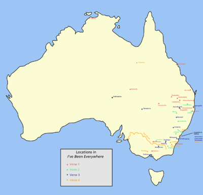
The place names listed are:
Verse 1: Tullamore
, Seymour
, Lismore
, Mooloolaba
, Nambour
, Maroochydore
, Kilmore
, Murwillumbah
, Birdsville
, Emmaville
, Wallaville, Cunnamulla
, Condamine
, Strathpine
, Proserpine
, Ulladulla
, Darwin
, Gin Gin
, Deniliquin, Muckadilla, Wallumbilla
, Boggabilla
, Kumbarilla.
Verse 2: Moree
, Taree
, Jerilderie
, Bambaroo, Toowoomba
, Gunnedah
, Caringbah
, Woolloomooloo
, Dalveen, Tamborine
, Engadine
, Jindabyne
, Lithgow
, Casino
, Brigalow
, Narromine
, Megalong
, Wyong
, Tuggerawong
, Wanganella
, Morella, Augathella
, Brindabella
Verse 3: Wollongong
, Geelong
, Kurrajong, Mullumbimby
, Mittagong
, Cooranbong
, Grong Grong
, Goondiwindi
, Yarra Yarra
, Bouindarra, Wallangarra
, Turramurra
, Boggabri
, Gundagai
, Narrabri
, Tibooburra
, Gulgong
, Adelong
, Billabong, Cabramatta
, Parramatta
, Wangaratta
, Coolangatta
Verse 4: Ettalong
, Dandenong
, Woodenbong
, Ballarat
, Canberra
, Milperra
, Unanderra
, Captains Flat
, Cloncurry
, River Murray, Kurri Kurri
, Girraween
, Terrigal
, Stockinbingal
, Collaroy
, Narrabeen
, Bendigo
, Dorrigo
, Bangalow
, Indooroopilly
, Kirribilli
, Yeerongpilly
, Wollondilly
For some of the above, there is more than one place in Australia with the same name (e.g. Coolangatta, Gin Gin
and Fingal
). The links given above are the most famous locations with those names.
in 1962. Snow thought the song had potential for the Canadian and American markets, but only if the place names were adapted to North America. At his publisher's urging, Geoff Mack consequently re-wrote the song using a North American atlas supplied to him by the publisher. The North American version starts: I was totin' my pack along the dusty Winnemucca
road. Below are the places mentioned in this version of the song, most of which are in North America, but a few of which are in Central and South America, e.g. Costa Rica
and Argentina
:
First verse: Reno
, Chicago
, Fargo, Minnesota
, Buffalo, Toronto
, Winslow, Sarasota, Wichita
, Tulsa, Ottawa
, Oklahoma
, Tampa
, Panama
, Mattawa, La Paloma
, Bangor, Baltimore
, Salvador, Amarillo, Tocopilla
, Barranquilla
and Padilla.
Second verse: Boston
, Charleston, Dayton
, Louisiana
, Washington
, Houston, Kingston, Texarkana, Monterey, Ferriday, Santa Fe, Tallapoosa, Glen Rock, Black Rock, Little Rock, Oskaloosa, Tennessee
, Hennessey
, Chicopee, Spirit Lake, Grand Lake, Devils Lake and Crater Lake
.
Third verse: Louisville
, Nashville, Knoxville, Ombabika, Schefferville, Jacksonville, Waterville, Costa Rica
, Pittsfield, Springfield, Bakersfield, Shreveport, Hackensack, Cadillac
, Fond du Lac, Davenport, Idaho
, Jellico, Argentina
, Diamantina, Pasadena and Catalina.
Fourth verse: Pittsburgh, Parkersburg, Gravelbourg, Colorado
, Ellensburg, Rexburg, Vicksburg, El Dorado
, Larimore, Atmore, Haverstraw, Chattanooga, Chaska, Nebraska
, Alaska
, Opelika, Baraboo, Waterloo, Kalamazoo, Kansas City, Sioux City, Cedar City and Dodge City.
First verse: Kaparoa, Whangaroa
, Akaroa
, Motueka
, Taramoa, Benmore, Pongaroa
, Horoeka, Rimutaka
, Te Karaka
, Whangarei
, Nuhaka
, Waimahaka
, Motuhura, Waikaka, Motunui
, Hokonui, Papanui
, Wainui
, Matawai
, Rongotai
, Pikowai
Second verse: Woodville
, Dargaville
, Lumsden
, Katikati
, Naseby
, Cambridge
, Porirua
, Mararoa, Hastings
, Tikitiki
, Tauranga
, Auckland
, Naenae
, Waitaha
, Hamilton
, Poroporo
, Taupo
, Timaru
, Oamaru
, Tihoi, Awanui
, Wanganui
, Pauanui
Third verse: Featherston
, Palmerston
, Woolston
, Te Awamutu
, Riverton
, Queenstown
, Picton
, Ohinemutu, Morere, Korere, Rotorua
, Kaikoura
, Matamata
, Ruakura
, Ikamatua
, Papakura
, Waitaki, Pukaki, Taranaki, Te Kauwhata
, Ropata, Ikowai, Waitemata
Fourth verse: Ruatoki
, Matahura, Taupiri, Maketu
, Kyeburn, Sowburn, Wedderburn
, Mossburn
, Washdyke
, Arawhata, Paparoa
, Kaponga
, Te Aroha
, Thames
, Kerikeri
, Kokoma, Tapanui
, Porinui, Tawanui, Otahuhu
, Ruatapu
, Mosgiel
, Whareroa
Fifth verse: Kapiti
, Ngawaka, Onepu
, Reporoa, Tongariro, Tomoana, Renwick
, Papamoa
, Karitane
, Oxford
, Parihaka
, Karetu
, Coalgate
, Whitecliffs
, Urenui
, Mamaku
, Waimea, Waharoa
, Dannevirke
, Ngahere
, Gordonton, Kingston
, Oban
(adapted by Michael Faubion): I got my snow machine stuck out on that windy Atmautluak trail.
Aunty Jack: I've been to Wollongong, Wollongong, Wollongong, Wollongong,...
The Beer Song adapted by Doug Moreland (2000): "Pabst Blue Ribbon, Old Samuel Adams, Bud Light, Corona, Foster’s, and Heineken, Nor don Blonde, got the girl on the front, If Homer were here he’d be drinking that Duff, Grolsch, and Guinness, and I ain’t finished I’ve drank a lot of beer."
Beer
s adapted by Jon Chalmers: "Scaeffer, Shiner, Horlacher, Heffenreffer, Coopers, Kruegers, Kingfisher, Knickerbocker, Fosters, Fullers, Lucky Lager, Silver Thunder, Miller, Paulener, Boulder, Old Peculiar, Rheingold, Michelob, Strohs, Grolsch, Guinness Gold, Yuengling, Carling, Youngs, and Little Kings...
Belgium
: Wies Willems, singer-songwriter from Vorselaar-Gent, wrote a cover in Dutch, in which he uses different places in Belgium. The song is performed by "The Lost Highwayknights."
Canada
: Stompin' Tom Connors
adds an extra spoken segment of locations in Ontario and a verse for locations in the Maritimes. He also substitutes Canadian cities, including Halifax
and Montreal
, at various points in the other verses. Mike Ford, formerly a member of Moxy Früvous
, did an all-Canadian version for his album, Canada Needs You, in 2005.
Canadian comedian Rick Moranis has a version called "I Ain't Goin' Nowhere" where he sings on why he won't leave his easy chair.
Czechoslovakia
(adapted by Ladislav Vodička
): Já tu zemi znám
Eugene Chadbourne
recorded a version on his 1988 album, also entitled I've Been Everywhere. He starts with Hank Snow's opening verse and then rattles off city names from all over the world (including Bogota
, Khartoum
and Nairobi
), throws in a gentle poke at Neil Young
and Farm Aid
, and ends with Eugene declaring that there's only one place he hasn't been to--Alcatraz
.
Faroe Islands
: Used as soundtrack in a commercial for a broadband internet service (Eitt), listing places in the Faroe Islands where the service is available (all). The commercial is often called "Eitt er allastaðni" because of the chorus. Some places mentioned: Tjørnuvík
, Dalur
, Sandur
, Mikladalur
, Fuglafjørður
, Skarvanes
, Sandavágur
, Oyri
, Froðba
.
Germany
(adapted by Jackie Leven
): "I was walking down the Ku'damm in the City of Berlin
." Complete with an entire verse of Baden-Baden
. Published on the 2007 album "Oh What A Blow That Phantom Dealt Me!"
Pennsylvania
(adapted by Earl Pickens): "I was totin' my pack along the old Conshohocken Road."
Springfield's state (adapted by Tim Long
): The Simpsons episode "Mobile Homer
" includes a version of the song listing the various fictional towns in the series.
Texas
(adapted By Brian Burns): I was totin’ my pack along the dusty Amarillo road.
Houston (adapted By Hayes Carll
): I been to Houston, Houston, Houston, Houston....
Scotland
(adapted By Charlene McGowan): I was totin' my pack along a winding Highland Mountain Road
WoW
(adapted By WorldofFilkcraft of YouTube
): I was totin' my packs along the dusty Barren's Gold Road.
Lists a number of places from inside the World of Warcaft game.
RuneScape
(adapted by Excl of YouTube
): I was totin' my staff along the stony Wizard Tower road.
Excl lists numerous RuneScape locations but moves onto listing things he "0wned". (See pwn
)
: Used the Australian version to advertise its new Next-G 3.5G mobile network in 2006. They also constantly use it in their BigPond Wireless Broadband advertisements featuring a family and friends travelling in a blue Volkswagen
Kombi around Australia.
Choice Hotels
: Used the Johnny Cash version in TV ads aired from 2005–present.
Additionally, 30-second snippets of the song have been created for the following locations:
Chicago
: The Chicago Transit Authority
used various neighborhoods/stops along the transit lines in two 2004 ads.
Dallas/Fort Worth Metroplex
: Dallas-based TexasLending.com uses suburbs in the Metroplex area.
Pittsburgh: KDKA
News Radio uses suburbs in the Pittsburgh region, where KDKA covers.
Faroe Islands
: EITT The melody with new lyrics is to be used in an advertising campaign for Faroese telecome company EITT.
New Brunswick
, Canada
: 2007 TV Ad for Enbridge Natural Gas with Provincial town & street names added. Seen often on CBC during hockey games.
Saskatchewan
: SaskTel
, the government-owned telecom in Saskatchewan, has a long-running television commercial that adapts the song to "I Go Everywhere," listing off small towns in the province where SaskTel Mobility coverage is available. The towns named are: Warman, Watson, Maidstone, Radisson, Fox Valley, Unity, Southey, Davidson, Meath Park, Lucky Lake, Candle Lake, Neilburg, Outlook, Shellbrook, Aberdeen, Strasbourg, Cut Knife, Springside, Indian Head, Lemburg, Elrose, Melville, and Biggar.
The Sports Network
(Canada): in 2010 used a verision of the song that listed all the cities and regions in the National Hockey League
to promote its coverage of trade deadline day.
Tennessee Governor's Highway Safety Office :
In 2010, used a version of the song in a television public service announcement claiming that law enforcement officers would be "everywhere" looking for impaired (drunk) drivers.
.
Kris Kristofferson also did an abbreviated version in the 1973 film "Pat Garrett and Billy the Kid" during his escape scene.
In October 2003 the publisher Rightsong Music BMI granted permission to Frank Loconto to write new lyrics and title for the 2004 presidential campaign of Bob Graham FL. Title: "I've Done Every Job. Man" commemorating the more than 300 'workdays' performed by Graham
during his 30 plus years of public service to the people of Florida.
The song recorded by Frank Loconto FXL Records was included in a promotional CD "Bob Graham Charisma Album 2004".
Australian Peter Harris commenced visiting all the locations in the Australian version of "I've Been Everywhere" in December 2009. A record of his trip is located at ivebeeneverywhere.com.au.
In 2010 the Swedish band Movits!
used the track for one of the episodes of their US tour movie "First we take Manhattan"
Geoff Mack
Albert Geoffrey McElhinney OAM , also known as Geoff Mack, is a country music singer and songwriter. He was awarded a Medal of the Order of Australia on 13 June 2005 with the citation, For service to country music and to the community, particularly through support for senior citizens' groups...
in 1959 and made popular by the singer Lucky Starr
Leslie Morrison
Leslie Morrison , better known by his stage name Lucky Starr, is an Australian singer. He released the tongue-twisting, "I've Been Everywhere" as a single in 1962, written by the singer-songwriter Geoff Mack, which name-drops numerous Australian towns...
in 1962.
The song (as originally written) listed Australia
Australia
Australia , officially the Commonwealth of Australia, is a country in the Southern Hemisphere comprising the mainland of the Australian continent, the island of Tasmania, and numerous smaller islands in the Indian and Pacific Oceans. It is the world's sixth-largest country by total area...
n towns. It was later adapted by Hank Snow
Hank Snow
Clarence Eugene "Hank" Snow was a Canadian-American country music artist. He charted more than 70 singles on the Billboard country charts from 1950 until 1980...
for North America
North America
North America is a continent wholly within the Northern Hemisphere and almost wholly within the Western Hemisphere. It is also considered a northern subcontinent of the Americas...
n (predominantly United States
United States
The United States of America is a federal constitutional republic comprising fifty states and a federal district...
) place names and by John Hore (later known as John Grenell) with New Zealand
New Zealand
New Zealand is an island country in the south-western Pacific Ocean comprising two main landmasses and numerous smaller islands. The country is situated some east of Australia across the Tasman Sea, and roughly south of the Pacific island nations of New Caledonia, Fiji, and Tonga...
place names (1966).
The song was a number 1 hit in Country Music in November 1962 in the United States for the recording artist Hank Snow. The song was also recorded by Lynn Anderson
Lynn Anderson
Lynn Rene Anderson is an American country music singer and equestrian known for a string of hits throughout the 1970s and early 1980s, most notably her Grammy Award-winning, worldwide mega-hit, " Rose Garden." Helped by her regular exposure on national television, Anderson was one of the most...
(USA 1970), Asleep At The Wheel
Asleep at the Wheel
Asleep at the Wheel is a American country music group that was formed in Paw Paw, West Virginia, but based in Austin, Texas. Altogether, they have won nine Grammy Awards since their 1970 inception. In their career, they have released more than twenty studio albums, and have charted more than twenty...
(USA 1973), Johnny Cash
Johnny Cash
John R. "Johnny" Cash was an American singer-songwriter, actor, and author, who has been called one of the most influential musicians of the 20th century...
(USA 1996), Chip Dockery, Ted Egan
Ted Egan
Edward Joseph Egan AO is an Australian folk musician, and was a public servant who served as Administrator of the Northern Territory from 2003 to 2007.-Early life:...
, Little Jan Buckner of Wendy Bagwell & The Sunliters (USA 1972), the "Farrelly Brothers" from the television series The Aunty Jack Show
The Aunty Jack Show
The Aunty Jack Show was a Logie Award–winning Australian television comedy series that ran from 1972 to 1973. Produced by and broadcast on ABC-TV, the series attained an instant cult status that persists to the present day....
(Australia 1974, a parody version), John Grenell (NZ 1966), Mike Ford (Canada, 2005), Rolf Harris
Rolf Harris
Rolf Harris, CBE, AM is an Australian musician, singer-songwriter, composer, painter and television personality.Born in Perth, Western Australia, Harris was a champion swimmer before studying art. He moved to England in 1952, where he started to appear on television programmes on which he drew the...
(UK 1963), Clifton Jansky, Willie Nelson
Willie Nelson
Willie Hugh Nelson is an American country music singer-songwriter, as well as an author, poet, actor, and activist. The critical success of the album Shotgun Willie , combined with the critical and commercial success of Red Headed Stranger and Stardust , made Nelson one of the most recognized...
, The Sunny Cowgirls
The Sunny Cowgirls
The Sunny Cowgirls are an Australian country music group formed in 2005. They have released a total of four studio albums since 2005. Their debut album, Little Bit Rusty, was released in 2005. Their latest album is entitled Summer and was released early 2010.-Biography:The Sunny Cowgirls, Sophie...
and the Statler Brothers. Harvey Reid also included the song in his Dreamer or Believer album.
Original singer Lucky Starr
Leslie Morrison
Leslie Morrison , better known by his stage name Lucky Starr, is an Australian singer. He released the tongue-twisting, "I've Been Everywhere" as a single in 1962, written by the singer-songwriter Geoff Mack, which name-drops numerous Australian towns...
released an EP called "Lucky's Been Everywhere," which contained 4 different versions: Great Britain, U.S.A., New Zealand, and Australia (Festival Records FX-10.485 (Australia)).
Australian version
Oodnadatta, South Australia
Oodnadatta, South Australia, is a small town surrounded by an area of with cattle stations in arid pastoral rangelands close to the Simpson Desert, north of Adelaide and 112 m above sea level. It can be reached by an unsealed road from Coober Pedy or via the unsealed Oodnadatta Track from...
road, When along came a semi with a high and canvas covered load, 'If you're goin' to Oodnadatta, mate, um, with me you can ride,' so I climbed in the cabin, and I settled down inside, He asked me if i'd seen a road with so much dust and sand, I said listen mate, I've traveled every road in this here land. 'Cause...
The place names listed are:
Verse 1: Tullamore
Tullamore, New South Wales
Tullamore is a small town in Parkes Shire in the Central West of New South Wales, Australia. At the 2006 census, Tullamore had a population of 211....
, Seymour
Seymour, Victoria
Seymour is a township in the Shire of Mitchell in the state of Victoria, Australia and is located north of Melbourne. At the 2006 census, Seymour had a population of 6,063...
, Lismore
Lismore, New South Wales
Lismore is a subtropical town in northeastern New South Wales, Australia. Lismore is the main population centre in the City of Lismore local government area. Lismore is a regional centre in the Northern Rivers region of the State.-History:...
, Mooloolaba
Mooloolaba, Queensland
Mooloolaba is a suburb and tourist resort township on the Sunshine Coast in Queensland, Australia. It is located north of the state capital, Brisbane, and is part of the Maroochydore urban centre.- Etymology :...
, Nambour
Nambour, Queensland
The area now known as Nambour, was first settled in 1870. The town was then called Petrie's Creek. In 1890 the Maroochy Divisional Board was established...
, Maroochydore
Maroochydore, Queensland
Maroochydore is an urban centre on the Sunshine Coast, Queensland, Australia.Maroochydore is a major commercial area of the Sunshine Coast with most shopping precincts located in the central business district. It is home to the Sunshine Plaza shopping centre and the Sunshine Coast's major bus...
, Kilmore
Kilmore, Victoria
Kilmore is a town in the Australian state of Victoria. Located north of Melbourne, it is contentiously claimed as Victoria's oldest inland settled town...
, Murwillumbah
Murwillumbah, New South Wales
Murwillumbah is a town of approximately 7,500 people in far north-eastern New South Wales, Australia in the Tweed Shire. It lies on the Tweed River, 848 km north-east of Sydney, 13 km south of the Queensland border and 132 km south of Brisbane. At the 2006 census, Murwillumbah had a...
, Birdsville
Birdsville, Queensland
-External links:*...
, Emmaville
Emmaville, New South Wales
Emmaville is a village on the Northern Tablelands in the New England region of New South Wales, Australia. It is in the Glen Innes Severn Council district.Emmaville is at an elevation of 890 metres AHD...
, Wallaville, Cunnamulla
Cunnamulla, Queensland
Cunnamulla is a small town that lies on the Warrego River in south west Queensland, Australia, south of Charleville, and approximately west of the state capital, Brisbane....
, Condamine
Condamine River
The Condamine River, part of the Murray-Darling Basin, drains the northern portion of the Darling Downs, an area of sub-coastal southern Queensland, Australia...
, Strathpine
Strathpine, Queensland
Strathpine is a suburb north of Brisbane, Queensland, Australia. Its Local Government Area is the Moreton Bay Region. It is home to the Pine Rivers District offices of the Moreton Bay Region as well as many businesses. The area contains a medium-sized Westfield shopping centre...
, Proserpine
Proserpine, Queensland
-External links:* * * * *...
, Ulladulla
Ulladulla, New South Wales
Ulladulla is a coastal town in New South Wales, Australia in the City of Shoalhaven local government area. It is on the Princes Highway, about half way between the larger towns of Batemans Bay to the south and Nowra to the north and approximately 179 km south of Sydney...
, Darwin
Darwin, Northern Territory
Darwin is the capital city of the Northern Territory, Australia. Situated on the Timor Sea, Darwin has a population of 127,500, making it by far the largest and most populated city in the sparsely populated Northern Territory, but the least populous of all Australia's capital cities...
, Gin Gin
Gin Gin, Queensland
Gin Gin is a small rural town located on the Bruce Highway in central Queensland, Australia, approximately 51 km west of Bundaberg and 370 km north-west of Brisbane, the state capital. The town owes its existence to its strategic location about halfway between Brisbane and Rockhampton. It...
, Deniliquin, Muckadilla, Wallumbilla
Wallumbilla, Queensland
Wallumbilla is a community in Queensland, Australia, situated five hours by road west from Brisbane, just east of Roma. At the 2006 census, Wallumbilla had a population of 285....
, Boggabilla
Boggabilla, New South Wales
Boggabilla is a small town in the far north of inland New South Wales, Australia in Moree Plains Shire. In 2006, the town had a population of 647 people....
, Kumbarilla.
Verse 2: Moree
Moree, New South Wales
Moree is a large town in Moree Plains Shire in northern New South Wales, Australia. It is located on the banks of the Mehi River in the centre of the rich black-soil plains....
, Taree
Taree, New South Wales
Taree is a city on the Mid North Coast, New South Wales, Australia. Taree and nearby Cundletown were settled in 1831 by William Wynter. Since then Taree has grown to a population of around 20,000 people and is the centre of a significant agricultural district. It is 16 km from the sea coast,...
, Jerilderie
Jerilderie, New South Wales
Jerilderie is a town of 768 people in the southern Riverina region of New South Wales, Australia. It is the only town in the Jerilderie Shire Local Government Area....
, Bambaroo, Toowoomba
Toowoomba, Queensland
Toowoomba is a city in Southern Queensland, Australia. It is located west of Queensland's capital city, Brisbane. With an estimated district population of 128,600, Toowoomba is Australia's second largest inland city and its largest non-capital inland city...
, Gunnedah
Gunnedah, New South Wales
Gunnedah is a town and Local government area in north-eastern New South Wales, Australia. 7,542 people lived in the town of Gunnedah in 2006, including 931 indigenous people ....
, Caringbah
Caringbah, New South Wales
Caringbah is a suburb, in southern Sydney, in the state of New South Wales, Australia. Caringbah is located 24 kilometres south of the Sydney central business district in the local government area of Sutherland Shire...
, Woolloomooloo
Woolloomooloo, New South Wales
Woolloomooloo is a harbourside, inner-city eastern suburb of Sydney, in the state of New South Wales, Australia. Woolloomooloo is located 1.5 kilometres east of the Sydney central business district, in the local government area of the City of Sydney. The suburb is located in a low-lying, former...
, Dalveen, Tamborine
Tamborine National Park
Tamborine is a national park in the Gold Coast hinterland of South East Queensland, Australia, 45 km south of Brisbane.It covers 11.60 km² on the plateau of Tamborine Mountain and around its foothills. The plateau is 8 km long, 5 km wide and rises to an altitude of 525 meters...
, Engadine
Engadine, New South Wales
Engadine is a suburb in southern Sydney, in the state of New South Wales, Australia. Engadine is located south of the Sydney central business district, in the local government area of the Sutherland Shire...
, Jindabyne
Jindabyne, New South Wales
Jindabyne is a town in south-east New South Wales, Australia that overlooks Lake Jindabyne near the Snowy Mountains, in Snowy River Shire. It is a popular holiday destination, especially in winter, due to its proximity to several ski resorts throughout the Kosciuszko National Park, including...
, Lithgow
Lithgow, New South Wales
Lithgow is a city in the Central Tablelands of New South Wales, Australia and is the centre of the local political division City of Lithgow. It is located in a mountain valley named Lithgow's Valley by John Oxley in honour of William Lithgow, the first Auditor-General of New South Wales.Lithgow is...
, Casino
Casino, New South Wales
Casino is a town in the Northern Rivers area of New South Wales, Australia, with a population of 9,400 people . It lies on the banks of the Richmond River and is situated at the junction of the Bruxner Highway and the Summerland Way....
, Brigalow
Brigalow, Queensland
Brigalow is a town in the Darling Downs region of Queensland, Australia. The town is located in the Western Downs Region local government area and on the Warrego Highway, north west of the state capital, Brisbane. At the 2006 census, Brigalow and the surrounding area had a population of...
, Narromine
Narromine, New South Wales
Narromine is a town located about 40 kilometres west of Dubbo in the Orana region of New South Wales, Australia. It is the centre of Narromine Shire. At the 2006 census, Narromine had a population of 3,599 people...
, Megalong
Megalong Valley
The Megalong Valley is part of the Blue Mountains of New South Wales, Australia. It is located west of Katoomba. On its eastern side, the valley is separated from the Jamison Valley by Narrow Neck Plateau. The Shipley Plateau overlooks part of the valley....
, Wyong
Wyong, New South Wales
Wyong was proclaimed a town in 1888 and is currently a major northern suburb of the Central Coast region of New South Wales, located approximately 89 km NNE of Sydney. It is the administrative centre for the Wyong Shire local government area.- History :...
, Tuggerawong
Tuggerawong, New South Wales
Tuggerawong is a suburb of the Central Coast region of New South Wales, Australia. It is part of the Wyong Shire local government area....
, Wanganella
Wanganella, New South Wales
Wanganella is a village community on the Billabong Creek in New South Wales, Australia. The settlement is on the Cobb Highway, located between Hay and Deniliquin . Wanganella is within the Conargo Shire Council local government area...
, Morella, Augathella
Augathella, Queensland
Augathella is a town in western Queensland, Australia, and is part of the Murweh Shire. Augathella lies on the Matilda Highway, is north of the town of Charleville, and west of Brisbane . The town lies on the banks of the Warrego River...
, Brindabella
Brindabella Ranges
The Brindabella Range is a mountain range located on the border between New South Wales and the Australian Capital Territory, Australia. The ranges rise to the west of Canberra, the capital city of Australia, and include the Namadgi National Park in the A.C.T. and Bimberi Nature Reserve and...
Verse 3: Wollongong
Wollongong, New South Wales
Wollongong is a seaside city located in the Illawarra region of New South Wales, Australia. It lies on the narrow coastal strip between the Illawarra Escarpment and the Pacific Ocean, 82 kilometres south of Sydney...
, Geelong
Geelong, Victoria
Geelong is a port city located on Corio Bay and the Barwon River, in the state of Victoria, Australia, south-west of the state capital; Melbourne. It is the second most populated city in Victoria and the fifth most populated non-capital city in Australia...
, Kurrajong, Mullumbimby
Mullumbimby, New South Wales
Mullumbimby is a town in the Northern Rivers region of New South Wales, Australia in Byron Shire, and is colloquially referred to as The Biggest Little Town in Australia. It lies at the foot of Mount Chincogan in the Brunswick Valley about from the sea...
, Mittagong
Mittagong, New South Wales
Mittagong is a town located in the Southern Highlands of New South Wales, Australia, in Wingecarribee Shire. At the 2006 census, Mittagong had a population of 7,460 people. The town can be seen as the gateway to the Southern Highlands when coming from Sydney. The town is close to Bowral, Berrima,...
, Cooranbong
Cooranbong, New South Wales
Cooranbong is a town and rural suburb of the City of Lake Macquarie in New South Wales, Australia, and is located west of the town of Morisset off the Sydney-Newcastle Freeway....
, Grong Grong
Grong Grong, New South Wales
Grong Grong is a small town in New South Wales, Australia on the Newell Highway, east of Narrandera in Narrandera Shire. At the 2006 census, Grong Grong had a population of 537 people....
, Goondiwindi
Goondiwindi, Queensland
Goondiwindi is an Australian town of approximately 5,629 people. The town has an annual population growth of 1.4 percent. The name Goondiwindi derives from an Aboriginal word meaning "the resting place of the birds".-History:...
, Yarra Yarra
Yarra River
The Yarra River, originally Birrarung, is a river in east-central Victoria, Australia. The lower stretches of the river is where the city of Melbourne was established in 1835 and today Greater Melbourne dominates and influences the landscape of its lower reaches...
, Bouindarra, Wallangarra
Wallangarra, Queensland
Wallangarra is a village on the border between Queensland and New South Wales in Australia. It is the third most southerly town in Queensland, 258 km south west of Brisbane. Wallangarra is on the Queensland side of the border and Jennings is on the New South Wales side...
, Turramurra
Turramurra, New South Wales
Turramurra is a suburb on the Upper North Shore of Sydney, in the state of New South Wales, Australia. Turramurra is located north of the Sydney central business district, in the local government area of Ku-ring-gai Council...
, Boggabri
Boggabri, New South Wales
Boggabri is a small town on the Kamilaroi Highway in north-western New South Wales, Australia in Narrabri Shire, between Gunnedah and Narrabri. In 2006, the town had a population of 901 people....
, Gundagai
Gundagai, New South Wales
Gundagai is a town in New South Wales, Australia. Although a small town, Gundagai is a popular topic for writers and has become a representative icon of a typical Australian country town...
, Narrabri
Narrabri, New South Wales
Narrabri is a town and seat of Narrabri Shire Council Local Government Area in the North West Slopes, New South Wales, Australia. Narrabri is situated on the Namoi River and lies northwest of Sydney. It sits on the junction of the Kamilaroi Highway and the Newell Highway...
, Tibooburra
Tibooburra, New South Wales
Tibooburra has an arid, desert climate with temperatures soaring above 40°Celsius in summer, often reaching as high as 47°C . Temperatures are milder in winter, averaging around 20°C in the daytime. These extreme temperatures make Tibooburra the hottest town in New South Wales, as reported on...
, Gulgong
Gulgong, New South Wales
Gulgong is a 19th century gold rush town in the Central-West of the Australian state of New South Wales. The town is located about north west of Sydney, and about 30 km north of Mudgee along the Castlereagh Highway. At the 2006 census, Gulgong had a population of 1,907 people...
, Adelong
Adelong, New South Wales
Adelong is a small town in the Riverina region of New South Wales, Australia and is a part of the Tumut Shire. The Adelong district has a population of about 1400, while Adelong itself has a population of 829 people....
, Billabong, Cabramatta
Cabramatta, New South Wales
Cabramatta is a suburb in south-western Sydney, in the state of New South Wales, Australia. Cabramatta is located 30 kilometres south-west of the Sydney central business district, in the local government area of the City of Fairfield...
, Parramatta
Parramatta, New South Wales
Parramatta is a suburb of Sydney, in the state of New South Wales, Australia. It is located in Greater Western Sydney west of the Sydney central business district on the banks of the Parramatta River. Parramatta is the administrative seat of the Local Government Area of the City of Parramatta...
, Wangaratta
Wangaratta, Victoria
Wangaratta is a cathedral city of almost 17,000 people in the northeast of Victoria, Australia, about from Melbourne along the Hume Highway, with Benalla to the southwest, and Albury-Wodonga to the northeast. It is located at the junction of the Ovens and King rivers which flow from the...
, Coolangatta
Coolangatta, Queensland
Coolangatta is the southernmost suburb of the Gold Coast, Queensland, Australia. It has a population of 4,869 and is named after the schooner Coolangatta which was wrecked there in 1846....
Verse 4: Ettalong
Ettalong Beach, New South Wales
Ettalong Beach is a suburb of the Central Coast region of New South Wales, Australia, located south of Woy Woy on Brisbane Water at the point where it meets Broken Bay, about 80km north of Sydney. It is part of the City of Gosford local government area...
, Dandenong
Dandenong, Victoria
Dandenong is a suburb and major urban centre in metropolitan Melbourne, Victoria, Australia, 30 km south-east from Melbourne's central business district. Situated on Dandenong Creek and mostly flat land at the foothills of Mount Dandenong, it is the main administrative centre for the City of...
, Woodenbong
Woodenbong, New South Wales
Woodenbong is a rural village in northern New South Wales, Australia, in Kyogle Council. It is 10 km south of the Queensland border. It is situated five kilometres south of the junction of the Summerland Way and the Mount Lindesay Road, which leads to Legume and eventually Tenterfield...
, Ballarat
Ballarat, Victoria
Ballarat is a city in the state of Victoria, Australia, approximately west-north-west of the state capital Melbourne situated on the lower plains of the Great Dividing Range and the Yarrowee River catchment. It is the largest inland centre and third most populous city in the state and the fifth...
, Canberra
Canberra
Canberra is the capital city of Australia. With a population of over 345,000, it is Australia's largest inland city and the eighth-largest city overall. The city is located at the northern end of the Australian Capital Territory , south-west of Sydney, and north-east of Melbourne...
, Milperra
Milperra, New South Wales
Milperra, a suburb of local government area City of Bankstown, is located 24 kilometres south-west of the Sydney central business district in the state of New South Wales, Australia, and is a part of the South-western Sydney region.-History:...
, Unanderra
Unanderra, New South Wales
Unanderra is a suburb of Wollongong in New South Wales, Australia. It is located approximately 10 km south-west of the Wollongong CBD. It is bordered to the west by Farmborough, Cordeaux Heights and Farmborough Heights in the Mount Kembla foothills, the north by Figtree, the east by Berkeley...
, Captains Flat
Captains Flat, New South Wales
Captains Flat is a town in the Southern Tablelands of New South Wales, Australia, in Palerang Shire. It is south of Queanbeyan.It is suggested that a bullock named "Captain" from Foxlow station, 12 km away, grazed here and hence the place name....
, Cloncurry
Cloncurry, Queensland
-Notable residents:*Writer Alexis Wright grew up in Cloncurry.*Association Footballer Kasey Wehrman was born in Cloncurry . He went on to play domestically and in Scandinavia. His achievements include winning a NSL Championship in 1996-1997 with the Brisbane Strikers and being capped several times...
, River Murray, Kurri Kurri
Kurri Kurri, New South Wales
Kurri Kurri is a small town in the Hunter Region of New South Wales, Australia, in the Cessnock LGA. At the 2006 census its population was 5,644...
, Girraween
Girraween, New South Wales
Girraween is a suburb of Sydney, in the state of New South Wales, Australia. Girraween is located 30 km west of the Sydney central business district, in the local government area of the City of Holroyd and is part of the Greater Western Sydney region....
, Terrigal
Terrigal, New South Wales
Terrigal is a major coastal suburb of the Central Coast region of New South Wales, Australia, located east of Gosford on the Pacific Ocean. It is part of the City of Gosford local government area....
, Stockinbingal
Stockinbingal, New South Wales
Stockinbingal is a village in Cootamundra Shire in the South West Slopes region of New South Wales, Australia. It is also a part of the Riverina, and is on the Burley Griffin Way...
, Collaroy
Collaroy, New South Wales
Collaroy is a suburb in northern Sydney, in the state of New South Wales, Australia. Collaroy is located 22 kilometres north-east of the Sydney central business district, in the local government area of Warringah Council and part of the Northern Beaches region...
, Narrabeen
Narrabeen, New South Wales
Narrabeen is a beachside suburb in northern Sydney, in the state of New South Wales, Australia. Narrabeen is located 23 kilometres north-east of the Sydney central business district, in the local government area of Warringah Council and is part of the Northern Beaches region.-History:There are a...
, Bendigo
Bendigo, Victoria
Bendigo is a major regional city in the state of Victoria, Australia, located very close to the geographical centre of the state and approximately north west of the state capital Melbourne. It is the second largest inland city and fourth most populous city in the state. The estimated urban...
, Dorrigo
Dorrigo, New South Wales
Dorrigo is a small town located on the Waterfall Way in northern New South Wales, Australia. It is approximately 580 kilometres north of the state capital, Sydney via the Pacific Highway, and 60 kilometres from the coastal city of Coffs Harbour. The town is situated on the Dorrigo Plateau near the...
, Bangalow
Bangalow, New South Wales
Bangalow is a small town in New South Wales, Australia, in Byron Shire with a population of 1,327. The town is 765 km north of Sydney and 167 km south of Brisbane, just off the Pacific Highway...
, Indooroopilly
Indooroopilly, Queensland
Indooroopilly is a suburb of Brisbane, Australia which is located 7 km west of the Brisbane central business district.- Name derivation and history :...
, Kirribilli
Kirribilli, New South Wales
Kirribilli is a suburb of Sydney, in the state of New South Wales, Australia. It is located three kilometres north of the Sydney central business district, in the local government area administered by North Sydney Council...
, Yeerongpilly
Yeerongpilly, Queensland
Yeerongpilly is a suburb of in Brisbane, Australia. It is 8 km south of the Brisbane central business district.Yeerongpilly is derived from the Aboriginal words "yarung" meaning sandy or gravelly or "yurong" meaning rain and "pilly" meaning gully or watercourse.Yeerongpilly grew from an area...
, Wollondilly
Wollondilly River
The Wollondilly River is a perennial river in New South Wales, Australia. It was originally a tributary of the Warragamba River, and hence of the Nepean and Hawkesbury Rivers...
For some of the above, there is more than one place in Australia with the same name (e.g. Coolangatta, Gin Gin
Gin Gin, Queensland
Gin Gin is a small rural town located on the Bruce Highway in central Queensland, Australia, approximately 51 km west of Bundaberg and 370 km north-west of Brisbane, the state capital. The town owes its existence to its strategic location about halfway between Brisbane and Rockhampton. It...
and Fingal
Fingal
Fingal is a county in Ireland. It is one of three smaller counties into which County Dublin was divided in 1994. With its county seat located in Swords, it has a population of 239,992 according to the 2006 census...
). The links given above are the most famous locations with those names.
North American version
Geoff Mack's music publisher offered the song to Canadian-born country musician Hank SnowHank Snow
Clarence Eugene "Hank" Snow was a Canadian-American country music artist. He charted more than 70 singles on the Billboard country charts from 1950 until 1980...
in 1962. Snow thought the song had potential for the Canadian and American markets, but only if the place names were adapted to North America. At his publisher's urging, Geoff Mack consequently re-wrote the song using a North American atlas supplied to him by the publisher. The North American version starts: I was totin' my pack along the dusty Winnemucca
Winnemucca, Nevada
-Demographics:As of the census of 2000, there were 7,174 people, 2,736 households, and 1,824 families residing in the city. The population density was 867.5 people per square mile . There were 3,280 housing units at an average density of 396.6 per square mile...
road. Below are the places mentioned in this version of the song, most of which are in North America, but a few of which are in Central and South America, e.g. Costa Rica
Costa Rica
Costa Rica , officially the Republic of Costa Rica is a multilingual, multiethnic and multicultural country in Central America, bordered by Nicaragua to the north, Panama to the southeast, the Pacific Ocean to the west and the Caribbean Sea to the east....
and Argentina
Argentina
Argentina , officially the Argentine Republic , is the second largest country in South America by land area, after Brazil. It is constituted as a federation of 23 provinces and an autonomous city, Buenos Aires...
:
First verse: Reno
Reno
Reno is the fourth most populous city in Nevada, US.Reno may also refer to:-Places:Italy*The Reno River, in Northern ItalyCanada*Reno No...
, Chicago
Chicago
Chicago is the largest city in the US state of Illinois. With nearly 2.7 million residents, it is the most populous city in the Midwestern United States and the third most populous in the US, after New York City and Los Angeles...
, Fargo, Minnesota
Minnesota
Minnesota is a U.S. state located in the Midwestern United States. The twelfth largest state of the U.S., it is the twenty-first most populous, with 5.3 million residents. Minnesota was carved out of the eastern half of the Minnesota Territory and admitted to the Union as the thirty-second state...
, Buffalo, Toronto
Toronto
Toronto is the provincial capital of Ontario and the largest city in Canada. It is located in Southern Ontario on the northwestern shore of Lake Ontario. A relatively modern city, Toronto's history dates back to the late-18th century, when its land was first purchased by the British monarchy from...
, Winslow, Sarasota, Wichita
Wichita, Kansas
Wichita is the largest city in the U.S. state of Kansas.As of the 2010 census, the city population was 382,368. Located in south-central Kansas on the Arkansas River, Wichita is the county seat of Sedgwick County and the principal city of the Wichita metropolitan area...
, Tulsa, Ottawa
Ottawa
Ottawa is the capital of Canada, the second largest city in the Province of Ontario, and the fourth largest city in the country. The city is located on the south bank of the Ottawa River in the eastern portion of Southern Ontario...
, Oklahoma
Oklahoma
Oklahoma is a state located in the South Central region of the United States of America. With an estimated 3,751,351 residents as of the 2010 census and a land area of 68,667 square miles , Oklahoma is the 28th most populous and 20th-largest state...
, Tampa
Tâmpa
Tâmpa may refer to several villages in Romania:* Tâmpa, a village in Băcia Commune, Hunedoara County* Tâmpa, a village in Miercurea Nirajului, Mureş County* Tâmpa, a mountain in Braşov city...
, Panama
Panama
Panama , officially the Republic of Panama , is the southernmost country of Central America. Situated on the isthmus connecting North and South America, it is bordered by Costa Rica to the northwest, Colombia to the southeast, the Caribbean Sea to the north and the Pacific Ocean to the south. The...
, Mattawa, La Paloma
La Paloma, Texas
La Paloma is a census-designated place in Cameron County, Texas, United States. The population was 354 at the 2000 census. It is part of the Brownsville–Harlingen Metropolitan Statistical Area. La Paloma means "the dove" in Spanish...
, Bangor, Baltimore
Baltimore
Baltimore is the largest independent city in the United States and the largest city and cultural center of the US state of Maryland. The city is located in central Maryland along the tidal portion of the Patapsco River, an arm of the Chesapeake Bay. Baltimore is sometimes referred to as Baltimore...
, Salvador, Amarillo, Tocopilla
Tocopilla
Tocopilla is a city and commune in the Antofagasta Region, in the north of Chile. It is the capital of the province that bears the same name.Tocopilla celebrates its anniversary on September 29 every year with a big show the day before, which includes a parade down the main street of the city, food...
, Barranquilla
Barranquilla
Barranquilla is an industrial port city and municipality located in northern Colombia, near the Caribbean Sea. The capital of the Atlántico Department, it is the largest industrial city and port in the Colombian Caribbean region with a population of 1,148,506 as of 2005, which makes it Colombia's...
and Padilla.
Second verse: Boston
Boston
Boston is the capital of and largest city in Massachusetts, and is one of the oldest cities in the United States. The largest city in New England, Boston is regarded as the unofficial "Capital of New England" for its economic and cultural impact on the entire New England region. The city proper had...
, Charleston, Dayton
Dayton
Dayton is a city in Ohio and the county seat of Montgomery County, Ohio, United States.Dayton may also refer to:-United States:*Dayton, Alabama*Dayton, California, in Butte County*Dayton, Lassen County, California*Dayton, Idaho*Dayton, Indiana...
, Louisiana
Louisiana
Louisiana is a state located in the southern region of the United States of America. Its capital is Baton Rouge and largest city is New Orleans. Louisiana is the only state in the U.S. with political subdivisions termed parishes, which are local governments equivalent to counties...
, Washington
Washington (disambiguation)
Washington commonly refers to:* George Washington , military general and first President of the United States of America* Washington , a state on the Pacific coast of the United States of America...
, Houston, Kingston, Texarkana, Monterey, Ferriday, Santa Fe, Tallapoosa, Glen Rock, Black Rock, Little Rock, Oskaloosa, Tennessee
Tennessee
Tennessee is a U.S. state located in the Southeastern United States. It has a population of 6,346,105, making it the nation's 17th-largest state by population, and covers , making it the 36th-largest by total land area...
, Hennessey
Hennessey, Oklahoma
Hennessey is a town in Kingfisher County, Oklahoma, United States. The population was 2,058 at the 2000 census.-History:Hennessey is named after Pat Hennessy, an Irish freighter who was killed at the present townsite in April, 1874...
, Chicopee, Spirit Lake, Grand Lake, Devils Lake and Crater Lake
Crater Lake
Crater Lake is a caldera lake located in the south-central region of the U.S. state of Oregon. It is the main feature of Crater Lake National Park and famous for its deep blue color and water clarity. The lake partly fills a nearly deep caldera that was formed around 7,700 years agoby the...
.
Third verse: Louisville
Louisville (disambiguation)
Louisville is the largest city in the U.S state of Kentucky.Louisville may also refer to:Cities and communities* Louisville-Jefferson County , Kentucky, a U.S...
, Nashville, Knoxville, Ombabika, Schefferville, Jacksonville, Waterville, Costa Rica
Costa Rica
Costa Rica , officially the Republic of Costa Rica is a multilingual, multiethnic and multicultural country in Central America, bordered by Nicaragua to the north, Panama to the southeast, the Pacific Ocean to the west and the Caribbean Sea to the east....
, Pittsfield, Springfield, Bakersfield, Shreveport, Hackensack, Cadillac
Cadillac (disambiguation)
-Geography:*Cadillac, Michigan, USA*Cadillac Mountain, Maine, USA*Cadillac, Saskatchewan, Canada*Cadillac, a former municipality now part of Rouyn-Noranda, Quebec, Canada*Cadillac, Gironde, a commune in the Gironde department, in southwestern France...
, Fond du Lac, Davenport, Idaho
Idaho
Idaho is a state in the Rocky Mountain area of the United States. The state's largest city and capital is Boise. Residents are called "Idahoans". Idaho was admitted to the Union on July 3, 1890, as the 43rd state....
, Jellico, Argentina
Argentina
Argentina , officially the Argentine Republic , is the second largest country in South America by land area, after Brazil. It is constituted as a federation of 23 provinces and an autonomous city, Buenos Aires...
, Diamantina, Pasadena and Catalina.
Fourth verse: Pittsburgh, Parkersburg, Gravelbourg, Colorado
Colorado
Colorado is a U.S. state that encompasses much of the Rocky Mountains as well as the northeastern portion of the Colorado Plateau and the western edge of the Great Plains...
, Ellensburg, Rexburg, Vicksburg, El Dorado
El Dorado
El Dorado is the name of a Muisca tribal chief who covered himself with gold dust and, as an initiation rite, dived into a highland lake.Later it became the name of a legendary "Lost City of Gold" that has fascinated – and so far eluded – explorers since the days of the Spanish Conquistadors...
, Larimore, Atmore, Haverstraw, Chattanooga, Chaska, Nebraska
Nebraska
Nebraska is a state on the Great Plains of the Midwestern United States. The state's capital is Lincoln and its largest city is Omaha, on the Missouri River....
, Alaska
Alaska
Alaska is the largest state in the United States by area. It is situated in the northwest extremity of the North American continent, with Canada to the east, the Arctic Ocean to the north, and the Pacific Ocean to the west and south, with Russia further west across the Bering Strait...
, Opelika, Baraboo, Waterloo, Kalamazoo, Kansas City, Sioux City, Cedar City and Dodge City.
New Zealand version
The New Zealand version starts: Well I was hitching a ride on a winding Hokitika road, when along came a lorry....First verse: Kaparoa, Whangaroa
Whangaroa
Whangaroa is a locality on the harbour of the same name in Northland, New Zealand.Whangaroa is 8km north-west from Kaeo and 45km north from Okaihau. The harbour is almost landlocked and is popular both as a fishing spot in its own right and as a base for deep-sea fishing.The harbour was the scene...
, Akaroa
Akaroa
Akaroa is a village on Banks Peninsula in the Canterbury region of the South Island of New Zealand, situated within a harbour of the same name—the name Akaroa is Kāi Tahu Māori for 'Long Harbour'.- Overview :...
, Motueka
Motueka
The town of Motueka in the South Island of New Zealand lies close to the mouth of the Motueka River, on the western shore of Tasman Bay. It is, after Nelson and Richmond, the third largest centre in the Tasman Region, with a population of 7125...
, Taramoa, Benmore, Pongaroa
Pongaroa
The small township of Pongaroa lies in Tararua, in the southeast of the North Island of New Zealand. It is located 110 kilometres southwest of Hastings and 200 kilometres northeast of Wellington. The nearest town is Pahiatua, 50 kilometres to the west. Popular Akitio Beach is 30 kilometres to the...
, Horoeka, Rimutaka
Rimutaka Range
The Rimutaka Range is one of several mountain ranges in the North Island of New Zealand which form a ridge running parallel with the east coast of the island between East Cape and Wellington.The ridge is at its most pronounced in the southern part of the island, where it consists of the Ruahine,...
, Te Karaka
Te Karaka
Te Karaka is a small settlement inland from Gisborne, in the northeast of New Zealand's North Island. It is located in the valley of the Waipaoa River close to its junction with its tributary, the Waihora River...
, Whangarei
Whangarei
Whangarei, pronounced , is the northernmost city in New Zealand and the regional capital of Northland Region. Although commonly classified as a city, it is officially part of the Whangarei District, administered by the Whangarei District Council a local body created in 1989 to administer both the...
, Nuhaka
Nuhaka
Nuhaka is a small settlement in the northern Hawke's Bay Region of New Zealand's eastern North Island, lying on State Highway 2 between Wairoa and Gisborne.Nuhaka is the tribal centre of the Rakaipaaka people, a Maori subtribe of Ngati Kahungunu...
, Waimahaka
Waimahaka
Waimahaka is a locality in the Southland region of New Zealand's South Island. It is situated in a rural area, inland from Toetoes Bay. Nearby settlements include Pine Bush and Titiroa to the northwest, Fortification and Te Peka to the east, Pukewao and Tokanui to the southwest, and Fortrose on...
, Motuhura, Waikaka, Motunui
Motunui
Motunui is a settlement in northern Taranaki, in the North Island of New Zealand. It is located on State Highway 3 close to the shore of the North Taranaki Bight, six kilometres east of Waitara....
, Hokonui, Papanui
Papanui
Papanui is a major suburb of Christchurch New Zealand. It is sited five kilometers to the northwest of the city centre. Papanui is a middle socio-economic area with a population of 3,543 consisting predominantly of Pākehā 92.3%, Māori 5.7%, Pacific peoples 2.5%, Asian 5.0%, Middle Eastern/Latin...
, Wainui
Wainui
Wainui is a locality in the Rodney District of New Zealand. Wainui is approximately 5.5 kilometres north-east of Waitoki and 10 km west of Orewa. The Wainui Stream flows south-west through the area, and exits into the Kaukapakapa River.-Education:...
, Matawai
Matawai, New Zealand
Matawai is a small settlement in the northeast of New Zealand's North Island. It is located on the upper reaches of the Motu River on State Highway 2 between Gisborne and Opotiki.It is in the Gisborne area.-External links:*...
, Rongotai
Rongotai
This article discusses the Wellington city suburb of Rongotai. For the article about the New Zealand parliamentary electorate of the same name see Rongotai ...
, Pikowai
Pikowai
Pikowai is a rural community located near the beach on the shoreline of the Eastern Bay of Plenty in the North Island of New Zealand. It is located 34 km south east of Te Puke and 10 kilometres north west of Matata...
Second verse: Woodville
Woodville, New Zealand
Woodville is a small town in the southern North Island of New Zealand, 75 km north of Masterton and 25 km east of Palmerston North. In the 2006 census 1,398 people are usually resident in Woodville, a decrease of 81 people, or 5.5%, since the 2001 Census.-Early History and Local...
, Dargaville
Dargaville
Dargaville is a town in the North Island of New Zealand. It is situated on the bank of the Northern Wairoa River in the Northland region. The town is located 55 kilometres southwest of Whangarei....
, Lumsden
Lumsden, New Zealand
Lumsden is a town in Southland, New Zealand. Lying in a gap in the surrounding hills, it is the location of a major junction halfway along the north-south road from Queenstown to Invercargill, where it is crossed by the east-west road from Gore to Te Anau. The town had a population of 453 as of the...
, Katikati
Katikati
Katikati is a town located on the Uretara Stream near the tidal inlet opened by Matakana Island in the Bay of Plenty, New Zealand. The nearest city is Tauranga, which is 40 kilometres to the southeast. Katikati lies 28 kilometres south of Waihi.Katikati was settled in 1875 by settlers from County...
, Naseby
Naseby, New Zealand
Naseby is a small town, formerly a borough, in the Maniototo area of Central Otago, New Zealand. It is named after a village in Northamptonshire, England....
, Cambridge
Cambridge, New Zealand
Cambridge is a town in the Waikato region of the North Island of New Zealand. Situated 24 kilometres southeast of Hamilton, on the banks of the Waikato River, Cambridge is known as "The Town of Trees & Champions".In the 1840s Cambridge had a Maori population but in the 1850's missionaries and...
, Porirua
Porirua
Porirua is a city in the Wellington Region of New Zealand, immediately north of the city of Wellington, with their central business districts 20 km apart. A large proportion of the population commutes to Wellington, so it may be considered a satellite city. It almost completely surrounds...
, Mararoa, Hastings
Hastings, New Zealand
The city of Hastings is a major urban settlement in the Hawke's Bay region of the North Island of New Zealand, and it is the largest settlement by population in Hawke's Bay. Hastings city is the administrative centre of the Hastings District...
, Tikitiki
Tikitiki
Tikitiki, formerly known as Kahukura, is a small township close to the estuary of the Waiapu River, 150 kilometres north of Gisborne in northeastern New Zealand. State Highway 35 passes through it, and the settlement is the easternmost point on the New Zealand highway network....
, Tauranga
Tauranga
Tauranga is the most populous city in the Bay of Plenty region, in the North Island of New Zealand.It was settled by Europeans in the early 19th century and was constituted as a city in 1963...
, Auckland
Auckland
The Auckland metropolitan area , in the North Island of New Zealand, is the largest and most populous urban area in the country with residents, percent of the country's population. Auckland also has the largest Polynesian population of any city in the world...
, Naenae
Naenae
Naenae is a suburb of the city of Lower Hutt in the North Island of New Zealand. It lies on the eastern edge of the floodplain of the Hutt River, four kilometres from the Lower Hutt Central business district. A small tributary of the Hutt, the Waiwhetu Stream, flows through the suburb.Naenae has a...
, Waitaha
Waitaha
Waitaha is an early historical Māori iwi . Inhabitants of the South Island of New Zealand, they were largely absorbed via marriage and conquest first by the Kāti Mamoe and then Ngāi Tahu from the 16th century onward....
, Hamilton
Hamilton, New Zealand
Hamilton is the centre of New Zealand's fourth largest urban area, and Hamilton City is the country's fourth largest territorial authority. Hamilton is in the Waikato Region of the North Island, approximately south of Auckland...
, Poroporo
Poroporo
Solanum aviculare, commonly called Poroporo or Kangaroo Apple , is a soft-wooded shrub native to New Zealand and the east coast of Australia.It can grow up to 12 feet tall...
, Taupo
Taupo
Taupo is a town on the shore of Lake Taupo in the centre of the North Island of New Zealand. It is the seat of the Taupo District Council and lies in the southern Waikato Region....
, Timaru
Timaru
TimaruUrban AreaPopulation:27,200Extent:Former Timaru City CouncilTerritorial AuthorityName:Timaru District CouncilPopulation:42,867 Land area:2,736.54 km² Mayor:Janie AnnearWebsite:...
, Oamaru
Oamaru
Oamaru , the largest town in North Otago, in the South Island of New Zealand, is the main town in the Waitaki District. It is 80 kilometres south of Timaru and 120 kilometres north of Dunedin, on the Pacific coast, and State Highway 1 and the railway Main South Line connects it to both...
, Tihoi, Awanui
Awanui
Awanui is a river port located 7 km north of Kaitaia, New Zealand. It lies at the south of the Aupouri Peninsula of the Northland Region. The Awanui River flows north to Rangaunu Bay. In the 1920s, kauri timber and gum from Kaitaia moved to the coast through Awanui.State Highway 1 and 10...
, Wanganui
Wanganui
Whanganui , also spelled Wanganui, is an urban area and district on the west coast of the North Island of New Zealand. It is part of the Manawatu-Wanganui region....
, Pauanui
Pauanui
The town of Pauanui meaning Big Paua in Maori is on the east coast of the Coromandel Peninsula in the North Island of New Zealand. It lies at the mouth of the Tairua River on its south bank, directly opposite the larger town of Tairua. The population was 741 in the 2006 Census, an increase of 42...
Third verse: Featherston
Featherston, New Zealand
Featherston is a town in the north of the Wellington Region region of New Zealand. It lies in the Wairarapa, just north of the Rimutaka Tunnel, in the South Wairarapa District. The population was 2,340 in the 2006 Census....
, Palmerston
Palmerston, New Zealand
The town of Palmerston, in New Zealand's South Island lies 50 kilometres to the north of the city of Dunedin. It is the largest town in the Waihemo Ward of the Waitaki District with a population of 890 residents...
, Woolston
Woolston, New Zealand
Woolston is a light industrial and residential suburb of Christchurch in the South Island of New Zealand. It is situated three kilometres southeast of the city centre, close to major arterial routes including State Highways 73 and 74 to Banks Peninsula...
, Te Awamutu
Te Awamutu
Te Awamutu is a town in the Waikato in the North Island of New Zealand. It is the council seat of the Waipa District and serves as a service town for the farming communities which surround it...
, Riverton
Riverton, New Zealand
Riverton or Aparima is a small town at the south of the South Island of New Zealand. It is in the Southland region and lies at the western end of Oreti Beach, 30 kilometres west of Invercargill on the Southern Scenic Route. It is approx. 45 km from Stewart Island and provides a safe harbour...
, Queenstown
Queenstown, New Zealand
Queenstown is a resort town in Otago in the south-west of New Zealand's South Island. It is built around an inlet called Queenstown Bay on Lake Wakatipu, a long thin Z-shaped lake formed by glacial processes, and has spectacular views of nearby mountains....
, Picton
Picton, New Zealand
Picton is a town in the Marlborough region of New Zealand. It is close to the head of Queen Charlotte Sound near the north-east corner of the South Island. The population was 2928 in the 2006 Census, a decrease of 72 from 2001...
, Ohinemutu, Morere, Korere, Rotorua
Rotorua
Rotorua is a city on the southern shores of the lake of the same name, in the Bay of Plenty region of the North Island of New Zealand. The city is the seat of the Rotorua District, a territorial authority encompassing the city and several other nearby towns...
, Kaikoura
Kaikoura
Kaikoura is a town on the east coast of the South Island of New Zealand. It is located on State Highway 1 180 km north of Christchurch.Kaikoura became the first local authority to reach the Green Globe tourism certification standard....
, Matamata
Matamata
Matamata is a rural Waikato town in New Zealand with a population of around 12,000 . It is located near the base of the Kaimai Ranges, and is a thriving farming area known for Thoroughbred horse breeding and training pursuits...
, Ruakura
Ruakura
Ruakura is a semi-rural suburb of Hamilton City, in the Waikato region of New Zealand. The University of Waikato is nearby. The area lies to the east of urban Hamilton and to the west of State Highway 1B .The Waikato region is a major contributor to New Zealand's agricultural-based economy, and...
, Ikamatua
Ikamatua
Ikamatua is a small village on the West Coast of the South Island in New Zealand.It is located on the State Highway 7 inland route, 50 km north of Greymouth and 28 km south of Reefton...
, Papakura
Papakura
The Papakura District was the name of a local council territory in New Zealand's Auckland Region that existed from 1989 until 2010. The area made up the southernmost part of the Auckland metropolitan area....
, Waitaki, Pukaki, Taranaki, Te Kauwhata
Te Kauwhata
Te Kauwhata is a small town in the north of the Waikato region of New Zealand, situated close to the western shore of Lake Waikare, some 40 km north of Hamilton...
, Ropata, Ikowai, Waitemata
Fourth verse: Ruatoki
Ruatoki
Ruatoki is a locality in the Bay of Plenty Region of New Zealand. It is located at the base of the Urewera Valley, approximately 20 km south of Whakatane. The predominantly Māori community of approximately 600 people affiliate with the Tūhoe iwi, with at least ten marae located in the area...
, Matahura, Taupiri, Maketu
Maketu
Maketu is a small town on the Bay of Plenty Coast in New Zealand. It is located on Okurei point and has an estuary from which the Kaituna River used to flow out of, it is also adjacent to Newdicks Beach located on the south eastern side of Okurei point. The name is sometimes informally abbreviated...
, Kyeburn, Sowburn, Wedderburn
Wedderburn, New Zealand
Wedderburn is a community in Central Otago, New Zealand. It is located 15 kilometres northwest of Ranfurly, and was at one time close to the centre of a thriving gold and coal mining area...
, Mossburn
Mossburn
Mossburn is a small town in the northern Southland Region of New Zealand, south of Queenstown and east of Te Anau. In 2001, it had a usually resident population of 240, consisting of 129 males and 111 females. This constituted a 12.1% decrease in population since the previous New Zealand Census of...
, Washdyke
Washdyke
Washdyke is an industrial suburb in the north of Timaru, in south Canterbury, New Zealand. State Highway 1 passes through Washdyke on the way north out of the city...
, Arawhata, Paparoa
Paparoa Ranges
The Paparoa Range is a mountain range in the West Coast region of New Zealand's South Island. It is located along the coast between the Buller and Grey Rivers, with the Inangahua River to the east. Some of the range is protected as the Paparoa National Park...
, Kaponga
Kaponga
Kaponga is a small town in the southern part of the Taranaki region of New Zealand. It is known as "The Gateway to Dawson's Falls" on Mount Taranaki/Egmont. Kaponga is located inland from Manaia and Eltham, and is on the main road connecting Eltham to Opunake. Opunaki is 26 km to the west and...
, Te Aroha
Te Aroha
Te Aroha is a rural town in the Waikato region of New Zealand with a population of 3,768 . It is 53 km northeast of Hamilton and 50 km south of Thames. It sits at the foot of 952-metre Mount Te Aroha, the highest point in the Kaimai Range....
, Thames
Thames, New Zealand
Thames is a town at the southwestern end of the Coromandel Peninsula in New Zealand's North Island. It is located on the Firth of Thames close to the mouth of the Waihou River. The town is the seat of the Thames-Coromandel District Council....
, Kerikeri
Kerikeri
Kerikeri, the largest town in the Northland Region of New Zealand, is a popular tourist destination about three hours drive north of Auckland, and 80 km north of Whangarei...
, Kokoma, Tapanui
Tapanui
Tapanui is a picturesque town in West Otago in New Zealand's South Island, close to the boundary with Southland region . A forestry town, it lies between the foot of the Blue Mountains and the Pomahaka River. Deer stalking and trout fishing are popular pastimes of the area...
, Porinui, Tawanui, Otahuhu
Otahuhu
Otahuhu is a suburb of Auckland. It is located to the southeast of the city centre, on a narrow isthmus between an arm of the Manukau Harbour to the west and the Tamaki River estuary to the east...
, Ruatapu
Ruatapu
In Māori tradition, Ruatapu was the second son of the great chief Uenuku, who belittled him for using the sacred comb of his elder brother, Kahutia-te-rangi. As revenge, Ruatapu enticed the children of the nobility into his canoe, sailed them in the ocean, and then sank it...
, Mosgiel
Mosgiel
Mosgiel is an urban satellite of Dunedin in Otago, New Zealand, fifteen kilometres west of the city's centre. Since the re-organisation of New Zealand local government in 1989 it has been inside the Dunedin City Council area, but was physically separate from the contiguous suburbs until...
, Whareroa
Fifth verse: Kapiti
Kapiti Coast
The Kapiti Coast is the name of the section of the coast of the south-western North Island of New Zealand that is north of Wellington and opposite Kapiti Island. It falls under the jurisdiction of the Wellington Regional Council...
, Ngawaka, Onepu
Onepu
Onepu is a small locality in the Bay of Plenty Region of the North Island of New Zealand. Onepu is situated between Kawerau and Te Teko along State Highway 34, and lies immediately north-east of the Norske Skog Tasman pulp and paper mill. The locality also lies on the Murupara Branch railway. Onepu...
, Reporoa, Tongariro, Tomoana, Renwick
Renwick, New Zealand
Renwick is a small town in Marlborough, New Zealand, close to the south bank of the Wairau River. It is located on State Highway 6, 12 km west of Blenheim. Havelock is 31 km north...
, Papamoa
Papamoa
Papamoa is the largest suburb of Tauranga in the Bay of Plenty region on the northeastern coast of the North Island of New Zealand....
, Karitane
Karitane
The seaside settlement of Karitane is located within the limits of the city of Dunedin in New Zealand, 35 kilometres to the north of the city centre....
, Oxford
Oxford, New Zealand
Oxford is a small town of 1,716 people serving the farming community of North Canterbury, New Zealand. It is part of the Waimakariri District. Oxford is a linear town, approximately two kilometres long. For a time Oxford was serviced by the Oxford Branch railway, and had two stations, East Oxford...
, Parihaka
Parihaka
Parihaka is a small community in Taranaki Region, New Zealand, located between Mount Taranaki and the Tasman Sea. In the 1870s and 1880s the settlement, then reputed to be the largest Māori village in New Zealand, became the centre of a major campaign of non-violent resistance to European...
, Karetu
Karetu
Karetu is a locality in the Northland Region of the North Island of New Zealand. Kawakawa is to the west, and Waikare is northeast. The Karetu River flows from the Russell Forest in the southeast through Karetu, and joins the Kawakawa River shortly before it flows into the Bay of Islands.The name...
, Coalgate
Coalgate, New Zealand
Coalgate is a locality in the Selwyn District of the Canterbury region of New Zealand's South Island. The 2001 New Zealand Census of Population and Dwellings gave Coalgate's population as 276, and it is located roughly an hour west of Christchurch on State Highway 77...
, Whitecliffs
Whitecliffs
Whitecliffs is a small town with a population of 117 in the Selwyn District of the Canterbury region of New Zealand's South Island. It has also been known as South Malvern , and the name of Whitecliffs comes from terrace cliffs above the Selwyn River...
, Urenui
Urenui
Urenui is a settlement in northern Taranaki, in the North Island of New Zealand. It is located on State Highway 3 close to the shore of the North Taranaki Bight, 13 kilometres east of Waitara and 6 km south-west of Mimi...
, Mamaku
Mamaku
Mamaku is a small town in the Bay of Plenty Region of the North Island of New Zealand. It lies on the Mamaku Plateau at an elevation of above sea level. Situated at the highest point of the now-mothballed Rotorua Branch railway line, the town is south of State Highway 5...
, Waimea, Waharoa
Waharoa
Waharoa is a rural community in New Zealand.Waharoa is the railway junction of the Kinleith Branch railway with the East Coast Main Trunk Railway.State Highway 27 runs through the town.-Schools:...
, Dannevirke
Dannevirke
Dannevirke , is a rural service town in the Manawatu-Wanganui Region of the North Island, New Zealand. It is the major town of the administrative Tararua District, the easternmost of the districts in which the Regional Council has responsibilities...
, Ngahere
Ngahere
Ngahere is a locality in the Grey District of the West Coast of New Zealand's South Island. The 2006 New Zealand Census of Population and Dwellings gave the population of Ngahere and its surrounding area as 345, an increase of 9.5% or 30 people since the 2001 census.Ngahere is located on the south...
, Gordonton, Kingston
Kingston, New Zealand
Kingston is a small town at the southernmost end of Lake Wakatipu on the border of Otago and Southland, in New Zealand's South Island. It is 47 kilometres south of Queenstown by a road which winds between the lake to the west and The Remarkables mountains to the east...
, Oban
Oban, New Zealand
Oban is the principal settlement on Stewart Island/Rakiura, the southernmost inhabited island of the New Zealand archipelago. Oban is located on Halfmoon Bay , on Paterson Inlet...
Other versions
AlaskaAlaska
Alaska is the largest state in the United States by area. It is situated in the northwest extremity of the North American continent, with Canada to the east, the Arctic Ocean to the north, and the Pacific Ocean to the west and south, with Russia further west across the Bering Strait...
(adapted by Michael Faubion): I got my snow machine stuck out on that windy Atmautluak trail.
Aunty Jack: I've been to Wollongong, Wollongong, Wollongong, Wollongong,...
The Beer Song adapted by Doug Moreland (2000): "Pabst Blue Ribbon, Old Samuel Adams, Bud Light, Corona, Foster’s, and Heineken, Nor don Blonde, got the girl on the front, If Homer were here he’d be drinking that Duff, Grolsch, and Guinness, and I ain’t finished I’ve drank a lot of beer."
Beer
Beer
Beer is the world's most widely consumed andprobably oldest alcoholic beverage; it is the third most popular drink overall, after water and tea. It is produced by the brewing and fermentation of sugars, mainly derived from malted cereal grains, most commonly malted barley and malted wheat...
s adapted by Jon Chalmers: "Scaeffer, Shiner, Horlacher, Heffenreffer, Coopers, Kruegers, Kingfisher, Knickerbocker, Fosters, Fullers, Lucky Lager, Silver Thunder, Miller, Paulener, Boulder, Old Peculiar, Rheingold, Michelob, Strohs, Grolsch, Guinness Gold, Yuengling, Carling, Youngs, and Little Kings...
Belgium
Belgium
Belgium , officially the Kingdom of Belgium, is a federal state in Western Europe. It is a founding member of the European Union and hosts the EU's headquarters, and those of several other major international organisations such as NATO.Belgium is also a member of, or affiliated to, many...
: Wies Willems, singer-songwriter from Vorselaar-Gent, wrote a cover in Dutch, in which he uses different places in Belgium. The song is performed by "The Lost Highwayknights."
Canada
Canada
Canada is a North American country consisting of ten provinces and three territories. Located in the northern part of the continent, it extends from the Atlantic Ocean in the east to the Pacific Ocean in the west, and northward into the Arctic Ocean...
: Stompin' Tom Connors
Stompin' Tom Connors
Charles Thomas "Stompin' Tom" Connors, OC is one of Canada's most prolific and well-known country and folk singers.He lives in Wellington County, Ontario.- Early life :...
adds an extra spoken segment of locations in Ontario and a verse for locations in the Maritimes. He also substitutes Canadian cities, including Halifax
City of Halifax
Halifax is a city in Canada, which was the capital of the province of Nova Scotia and shire town of Halifax County. It was the largest city in Atlantic Canada until it was amalgamated into Halifax Regional Municipality in 1996...
and Montreal
Montreal
Montreal is a city in Canada. It is the largest city in the province of Quebec, the second-largest city in Canada and the seventh largest in North America...
, at various points in the other verses. Mike Ford, formerly a member of Moxy Früvous
Moxy Früvous
Moxy Früvous was a politically satirical folk-pop band from Thornhill, Ontario, Canada. The band was founded in 1989, and was active throughout the 1990s...
, did an all-Canadian version for his album, Canada Needs You, in 2005.
Canadian comedian Rick Moranis has a version called "I Ain't Goin' Nowhere" where he sings on why he won't leave his easy chair.
Czechoslovakia
Czechoslovakia
Czechoslovakia or Czecho-Slovakia was a sovereign state in Central Europe which existed from October 1918, when it declared its independence from the Austro-Hungarian Empire, until 1992...
(adapted by Ladislav Vodička
Ladislav Vodička
Ladislav Vodička was a Czech country music singer and songwriter, who performed for the group Jiri Brabec and then with his own group Hydrophilidae. Vodička graduated from the Faculty of Mechanical Engineering CTU. Singing began in 1961 with an amateur band Tempest...
): Já tu zemi znám
Eugene Chadbourne
Eugene Chadbourne
Eugene Chadbourne is an American improvisor, guitarist and banjoist. Highly eclectic and unconventional, Chadbourne's most formative influence is free jazz. He has also been a reviewer for Allmusic and a contributor to Maximum RocknRoll.Chadbourne started out playing rock and roll guitar, but...
recorded a version on his 1988 album, also entitled I've Been Everywhere. He starts with Hank Snow's opening verse and then rattles off city names from all over the world (including Bogota
Bogotá
Bogotá, Distrito Capital , from 1991 to 2000 called Santa Fé de Bogotá, is the capital, and largest city, of Colombia. It is also designated by the national constitution as the capital of the department of Cundinamarca, even though the city of Bogotá now comprises an independent Capital district...
, Khartoum
Khartoum
Khartoum is the capital and largest city of Sudan and of Khartoum State. It is located at the confluence of the White Nile flowing north from Lake Victoria, and the Blue Nile flowing west from Ethiopia. The location where the two Niles meet is known as "al-Mogran"...
and Nairobi
Nairobi
Nairobi is the capital and largest city of Kenya. The city and its surrounding area also forms the Nairobi County. The name "Nairobi" comes from the Maasai phrase Enkare Nyirobi, which translates to "the place of cool waters". However, it is popularly known as the "Green City in the Sun" and is...
), throws in a gentle poke at Neil Young
Neil Young
Neil Percival Young, OC, OM is a Canadian singer-songwriter who is widely regarded as one of the most influential musicians of his generation...
and Farm Aid
Farm Aid
Farm Aid started as a benefit concert on September 22, 1985, in Champaign, Illinois, held to raise money for family farmers in the United States...
, and ends with Eugene declaring that there's only one place he hasn't been to--Alcatraz
Alcatraz Island
Alcatraz Island is an island located in the San Francisco Bay, offshore from San Francisco, California, United States. Often referred to as "The Rock" or simply "Traz", the small island was developed with facilities for a lighthouse, a military fortification, a military prison, and a Federal...
.
Faroe Islands
Faroe Islands
The Faroe Islands are an island group situated between the Norwegian Sea and the North Atlantic Ocean, approximately halfway between Scotland and Iceland. The Faroe Islands are a self-governing territory within the Kingdom of Denmark, along with Denmark proper and Greenland...
: Used as soundtrack in a commercial for a broadband internet service (Eitt), listing places in the Faroe Islands where the service is available (all). The commercial is often called "Eitt er allastaðni" because of the chorus. Some places mentioned: Tjørnuvík
Tjørnuvík
Tjørnuvík is the northernmost village on the Faroese island of Streymoy in the Sunda Kommuna municipality. The 2002 population was 64. Its postal code is FO 445. Its current church was built in 1937.-External links:*-See also:...
, Dalur
Dalur
Dalur is a village in the Faroe Islands. Dalur is located on the east-side of Sandoy.The village lies in the bottom of a relatively large valley. Dalur means valley in Faroese.A little road leads from Dalur to the south-tip of the island...
, Sandur
Sandur
A sandur is a glacial outwash plain formed of sediments deposited by meltwater at the terminus of a glacier.- Formation :Sandar are found in glaciated areas, such as Svalbard, Kerguelen Islands, and Iceland...
, Mikladalur
Mikladalur
Mikladalur is a village on the Faroese island of Kalsoy in the municipality of Klaksvíkar. The 2005 population was 44. Its postal code is FO 797. The town's stone church dates from 1856. A tunnel to Trøllanes was completed in 1985.-External links:*...
, Fuglafjørður
Fuglafjørður
Fuglafjørður is a village on Eysturoy's east coast in the Faroe Islands. Its name means "fjord of birds".* Population: 1562* Location: * Postal code : FO 530* Municipality: Fuglafjardar* Football team: ÍF Fuglafjørður...
, Skarvanes
Skarvanes
Skarvanes is a deserted village on Sandoy, in the Faroe Islands. Its last permanent inhabitant died in 2000, although there is still a family living in a nearby valley. The former residential houses in the scenic village are used as summer houses and for similar purposes nowadays....
, Sandavágur
Sandavágur
The town of Sandavágur lies on the south coast of the Faroese island of Vágar, and has been voted the most well-kept village in the Faroes twice. The name Sandavágur means sandy creek and refers to the beach down by the inlet. From one point in Sandavágur you can get a view of all the southern...
, Oyri
Oyri
Oyri is a village on the central west coast of the Faroese island Eysturoy in the Sunda municipality. The 2005 population was 142. Its postal code is FO 450. The village is south of the Eysturoy-to-Streymoy bridge, and is home to a large fish processing plant.The name Oyri is usually translated as...
, Froðba
Froðba
Froðba is a village located farthest out on the north brink of Trongisvágsfjørður, an inlet on the east coast of the island of Suðuroy in the Faroe Islands. The village has eventually merged with the harbour-city of Tvøroyri....
.
Germany
Germany
Germany , officially the Federal Republic of Germany , is a federal parliamentary republic in Europe. The country consists of 16 states while the capital and largest city is Berlin. Germany covers an area of 357,021 km2 and has a largely temperate seasonal climate...
(adapted by Jackie Leven
Jackie Leven
Jackie Leven was a Scottish songwriter and folk musician. After starting his career as a folk musician in the late 1960s, he first found success with new wave band Doll by Doll...
): "I was walking down the Ku'damm in the City of Berlin
Berlin
Berlin is the capital city of Germany and is one of the 16 states of Germany. With a population of 3.45 million people, Berlin is Germany's largest city. It is the second most populous city proper and the seventh most populous urban area in the European Union...
." Complete with an entire verse of Baden-Baden
Baden-Baden
Baden-Baden is a spa town in Baden-Württemberg, Germany. It is located on the western foothills of the Black Forest, on the banks of the Oos River, in the region of Karlsruhe...
. Published on the 2007 album "Oh What A Blow That Phantom Dealt Me!"
Pennsylvania
Pennsylvania
The Commonwealth of Pennsylvania is a U.S. state that is located in the Northeastern and Mid-Atlantic regions of the United States. The state borders Delaware and Maryland to the south, West Virginia to the southwest, Ohio to the west, New York and Ontario, Canada, to the north, and New Jersey to...
(adapted by Earl Pickens): "I was totin' my pack along the old Conshohocken Road."
Springfield's state (adapted by Tim Long
Tim Long
Tim Long is a comedy writer born in Brandon, Manitoba, Canada. Tim calls Exeter, Ontario, Canada his home town and has written for The Simpsons, Politically Incorrect, Spy Magazine and The Late Show with David Letterman. Currently credited as a consulting producer on The Simpsons, Long was - until...
): The Simpsons episode "Mobile Homer
Mobile Homer
"Mobile Homer" is the thirteenth episode of the sixteenth season of the American animated television series The Simpsons. It was first broadcast on the Fox network in the United States on March 20, 2005. In the episode, Marge saves money for life insurance, worried about Homer after a near-fatal...
" includes a version of the song listing the various fictional towns in the series.
Texas
Texas
Texas is the second largest U.S. state by both area and population, and the largest state by area in the contiguous United States.The name, based on the Caddo word "Tejas" meaning "friends" or "allies", was applied by the Spanish to the Caddo themselves and to the region of their settlement in...
(adapted By Brian Burns): I was totin’ my pack along the dusty Amarillo road.
Houston (adapted By Hayes Carll
Hayes Carll
Joshua Hayes Carll , known as Hayes Carll, is a Texas Country singer-songwriter from The Woodlands, Texas ....
): I been to Houston, Houston, Houston, Houston....
Scotland
Scotland
Scotland is a country that is part of the United Kingdom. Occupying the northern third of the island of Great Britain, it shares a border with England to the south and is bounded by the North Sea to the east, the Atlantic Ocean to the north and west, and the North Channel and Irish Sea to the...
(adapted By Charlene McGowan): I was totin' my pack along a winding Highland Mountain Road
WoW
World of Warcraft
World of Warcraft is a massively multiplayer online role-playing game by Blizzard Entertainment. It is the fourth released game set in the fantasy Warcraft universe, which was first introduced by Warcraft: Orcs & Humans in 1994...
(adapted By WorldofFilkcraft of YouTube
YouTube
YouTube is a video-sharing website, created by three former PayPal employees in February 2005, on which users can upload, view and share videos....
): I was totin' my packs along the dusty Barren's Gold Road.
Lists a number of places from inside the World of Warcaft game.
RuneScape
RuneScape
RuneScape is a fantasy massively multiplayer online role-playing game released in January 2001 by Andrew and Paul Gower, and developed and published by Jagex Games Studio. It is a graphical browser game implemented on the client-side in Java, and incorporates 3D rendering...
(adapted by Excl of YouTube
YouTube
YouTube is a video-sharing website, created by three former PayPal employees in February 2005, on which users can upload, view and share videos....
): I was totin' my staff along the stony Wizard Tower road.
Excl lists numerous RuneScape locations but moves onto listing things he "0wned". (See pwn
Pwn
Pwn is a leetspeak slang term derived from the verb own, as meaning to appropriate or to conquer to gain ownership. The term implies domination or humiliation of a rival, used primarily in the Internet-based video game culture to taunt an opponent who has just been soundly defeated .In hacker...
)
Use of the song in advertising
TelstraTelstra
Telstra Corporation Limited is an Australian telecommunications and media company, building and operating telecommunications networks and marketing voice, mobile, internet access and pay television products and services....
: Used the Australian version to advertise its new Next-G 3.5G mobile network in 2006. They also constantly use it in their BigPond Wireless Broadband advertisements featuring a family and friends travelling in a blue Volkswagen
Volkswagen
Volkswagen is a German automobile manufacturer and is the original and biggest-selling marque of the Volkswagen Group, which now also owns the Audi, Bentley, Bugatti, Lamborghini, SEAT, and Škoda marques and the truck manufacturer Scania.Volkswagen means "people's car" in German, where it is...
Kombi around Australia.
Choice Hotels
Choice Hotels
Choice Hotels International is a hospitality holding corporation which is affiliated with several hotel brands and is based in Silver Spring, Maryland...
: Used the Johnny Cash version in TV ads aired from 2005–present.
Additionally, 30-second snippets of the song have been created for the following locations:
Chicago
Chicago
Chicago is the largest city in the US state of Illinois. With nearly 2.7 million residents, it is the most populous city in the Midwestern United States and the third most populous in the US, after New York City and Los Angeles...
: The Chicago Transit Authority
Chicago Transit Authority
Chicago Transit Authority, also known as CTA, is the operator of mass transit within the City of Chicago, Illinois and some of its surrounding suburbs....
used various neighborhoods/stops along the transit lines in two 2004 ads.
Dallas/Fort Worth Metroplex
Dallas/Fort Worth Metroplex
The Dallas–Fort Worth–Arlington Metropolitan Statistical Area, a title designated by the U.S. Census as of 2003, encompasses 12 counties within the U.S. state of Texas. The area is divided into two metropolitan divisions: Dallas–Plano–Irving and Fort Worth–Arlington. Residents of the area...
: Dallas-based TexasLending.com uses suburbs in the Metroplex area.
Pittsburgh: KDKA
KDKA (AM)
KDKA is a radio station licensed to Pittsburgh, Pennsylvania, USA. Created by the Westinghouse Electric Corporation on November 2, 1920, it is one of the world's first modern radio stations , a distinction that has also been challenged by other stations, although it has claimed to be the first in...
News Radio uses suburbs in the Pittsburgh region, where KDKA covers.
Faroe Islands
Faroe Islands
The Faroe Islands are an island group situated between the Norwegian Sea and the North Atlantic Ocean, approximately halfway between Scotland and Iceland. The Faroe Islands are a self-governing territory within the Kingdom of Denmark, along with Denmark proper and Greenland...
: EITT The melody with new lyrics is to be used in an advertising campaign for Faroese telecome company EITT.
New Brunswick
New Brunswick
New Brunswick is one of Canada's three Maritime provinces and is the only province in the federation that is constitutionally bilingual . The provincial capital is Fredericton and Saint John is the most populous city. Greater Moncton is the largest Census Metropolitan Area...
, Canada
Canada
Canada is a North American country consisting of ten provinces and three territories. Located in the northern part of the continent, it extends from the Atlantic Ocean in the east to the Pacific Ocean in the west, and northward into the Arctic Ocean...
: 2007 TV Ad for Enbridge Natural Gas with Provincial town & street names added. Seen often on CBC during hockey games.
Saskatchewan
Saskatchewan
Saskatchewan is a prairie province in Canada, which has an area of . Saskatchewan is bordered on the west by Alberta, on the north by the Northwest Territories, on the east by Manitoba, and on the south by the U.S. states of Montana and North Dakota....
: SaskTel
SaskTel
Saskatchewan Telecommunications is a provincial Crown Corporation operating under the authority of the Saskatchewan Telecommunications Act. It is the only remaining Crown Corporation in the Canadian telecommunications industry....
, the government-owned telecom in Saskatchewan, has a long-running television commercial that adapts the song to "I Go Everywhere," listing off small towns in the province where SaskTel Mobility coverage is available. The towns named are: Warman, Watson, Maidstone, Radisson, Fox Valley, Unity, Southey, Davidson, Meath Park, Lucky Lake, Candle Lake, Neilburg, Outlook, Shellbrook, Aberdeen, Strasbourg, Cut Knife, Springside, Indian Head, Lemburg, Elrose, Melville, and Biggar.
The Sports Network
The Sports Network
The Sports Network, commonly abbreviated as TSN, is a Canadian English language Category C specialty channel and is Canada's leading English language sports TV channel. TSN premiered in 1984, in the first group of Canadian specialty cable channels...
(Canada): in 2010 used a verision of the song that listed all the cities and regions in the National Hockey League
National Hockey League
The National Hockey League is an unincorporated not-for-profit association which operates a major professional ice hockey league of 30 franchised member clubs, of which 7 are currently located in Canada and 23 in the United States...
to promote its coverage of trade deadline day.
Tennessee Governor's Highway Safety Office :
In 2010, used a version of the song in a television public service announcement claiming that law enforcement officers would be "everywhere" looking for impaired (drunk) drivers.
Other uses
The song was used in the title sequence of the 2004 film Flight of the PhoenixFlight of the Phoenix (2004 film)
Flight of the Phoenix is a 2004 remake of a 1965 film, both based on the 1964 novel The Flight of the Phoenix, by Elleston Trevor, about a group of people who survive a plane crash in the Gobi Desert and must build a new plane out of the old one to escape. The film stars Dennis Quaid, Tyrese...
.
Kris Kristofferson also did an abbreviated version in the 1973 film "Pat Garrett and Billy the Kid" during his escape scene.
In October 2003 the publisher Rightsong Music BMI granted permission to Frank Loconto to write new lyrics and title for the 2004 presidential campaign of Bob Graham FL. Title: "I've Done Every Job. Man" commemorating the more than 300 'workdays' performed by Graham
during his 30 plus years of public service to the people of Florida.
The song recorded by Frank Loconto FXL Records was included in a promotional CD "Bob Graham Charisma Album 2004".
Australian Peter Harris commenced visiting all the locations in the Australian version of "I've Been Everywhere" in December 2009. A record of his trip is located at ivebeeneverywhere.com.au.
In 2010 the Swedish band Movits!
Movits!
Movits! is a Swedish music group from Luleå. The group plays swing mixed with hip hop. Their debut album Äppelknyckarjazz, literally translated as Apple swiper jazz, was released in November 2008 and has been recognized by national Swedish newspaper Dagens Nyheter...
used the track for one of the episodes of their US tour movie "First we take Manhattan"